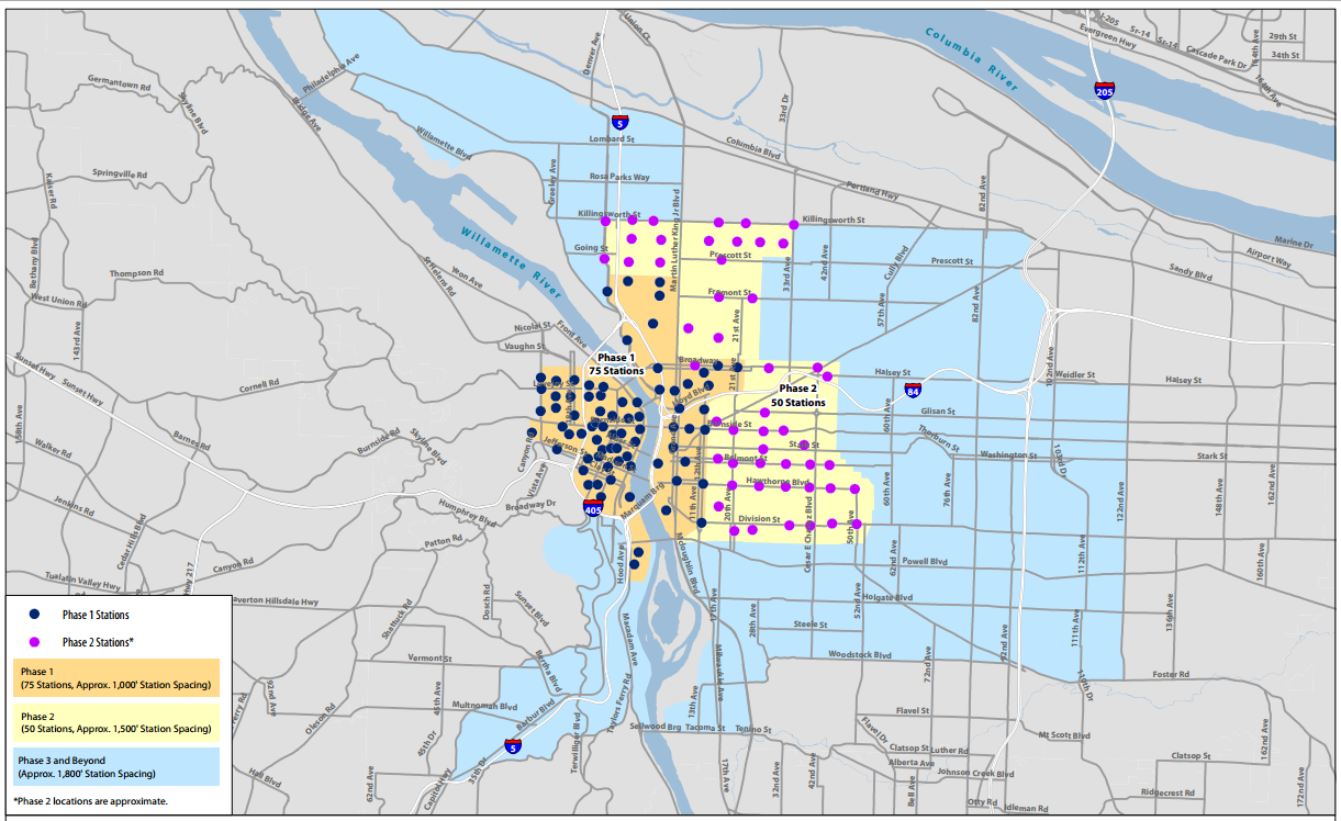
The main gripe Portlanders seem to have about bikesharing so far isn’t that it’s a bad idea — it’s that there isn’t going to be enough of it.
This is, as TriMet officials often say when they’re trying to cheer themselves up, a pretty good problem to have.
In the meantime, however, it’s still an interesting puzzle — as Willamette Week showed last week with a characteristically dramatic article reporting that the City of Portland is planning to focus its stations in the central city (something it’s been clear about from the beginning) and that (in a new development) it’s planning to grease the wheels for bikeshare sponsorship by offering to pay the up-front cost, essentially as a loan, should private sponsors step forward. (WW’s article also said unnamed sources think the likeliest sponsor is health company Kaiser Permanente.)
Also, as we shared in this week’s Monday Roundup, Transportation Nation has been reporting on the failure of Alta’s New York City bikeshare system to expand out of Manhattan as promptly as it said it would.
It all adds up to some legitimate concerns: With only enough money for 75 bikeshare stations in Portland, which neighborhoods should get them?
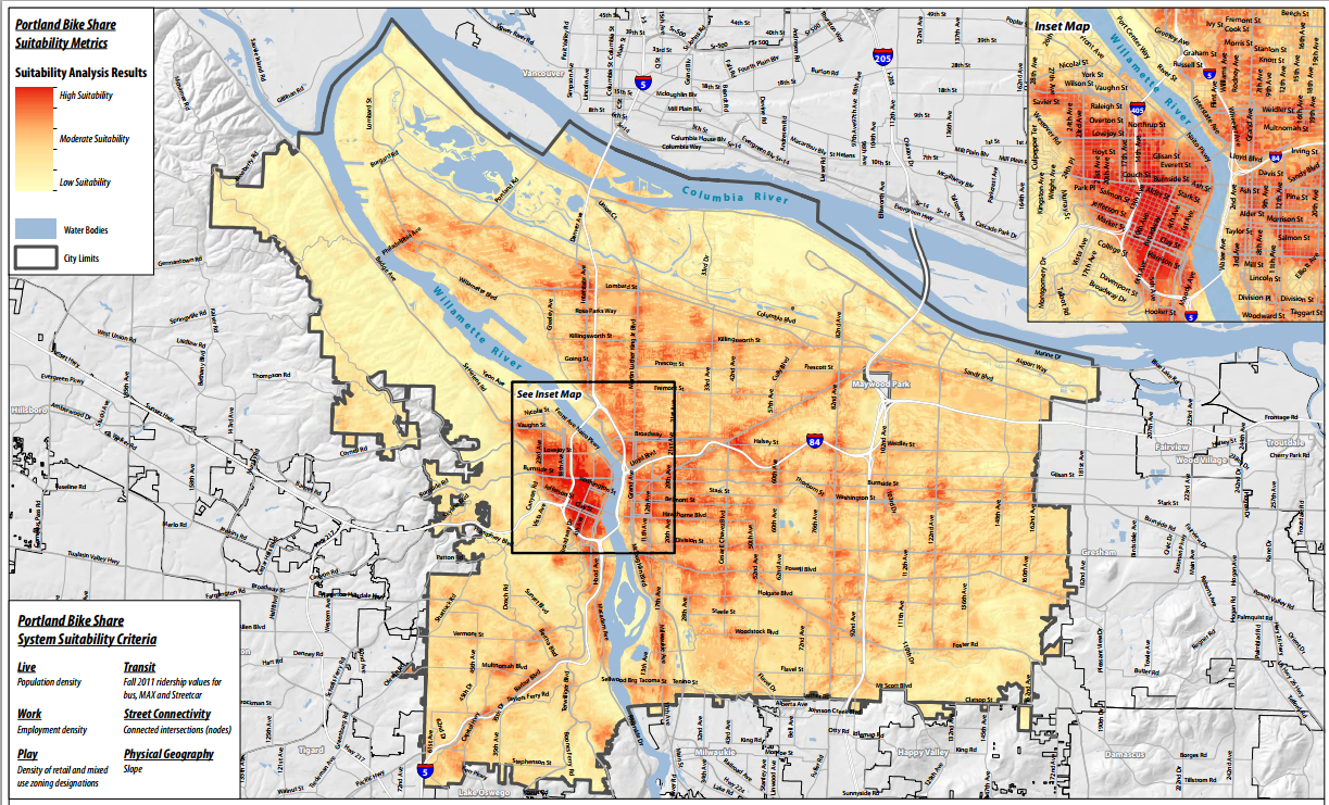
To answer that question, let’s look at some maps. First, let’s start with one prepared by Alta using a six-part formula they’ve developed in the eight cities where they currently operate bikeshare systems: residential density, job density, retail/mixed-use density, transit ridership, street connectivity and flat terrain:
Compare this to a similar analysis of “suitability” in Washington DC’s successful bikeshare program, including dots where the stations actually wound up:
And here’s a map showing which stations drew the most rides:
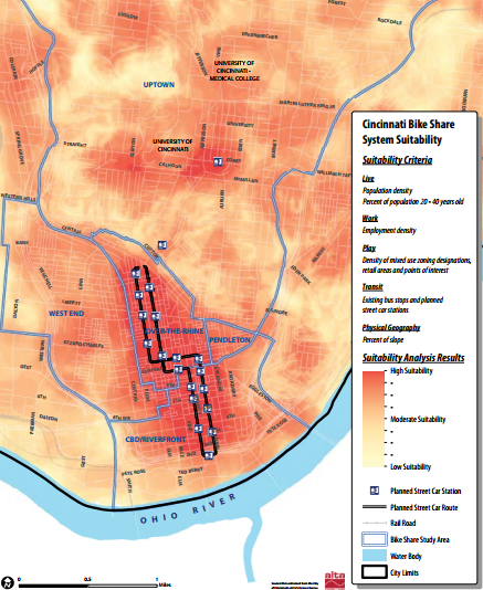
Alta did similar analyses in two cities close to Portland’s size, Cincinnati and Calgary:
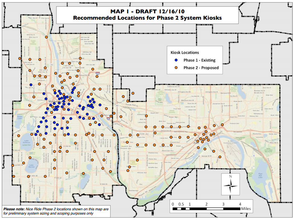
And here are the first and proposed second phases of Minneapolis’s Nice Ride system, the one that’s likely to be most similar to Portland’s in user base and initial size. It successfully opened the second round of stations one year after launch, and a third round of stations a year after that. Total ridership has continued to grow rapidly thanks to that expansion, but ridership per station was highest when the system was confined to the central city.
Ridership, however, isn’t everything. Portland’s public startup cash for bikeshare came from a federal grant intended specifically for “equity,” and city council approved it only after committing to a “robust public process” about how to make it useful for poor Portlanders and Portlanders of color.
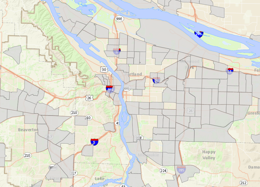
So, would stations downtown serve only the white and well-to-do? Well, here’s a map from the Coalition for a Livable Future’s Regional Equity Atlas showing the Census tracts with above-average percentages of residents in poverty in 2010:
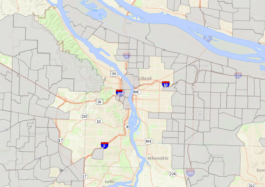
And here’s one showing above-average percentages of people of color as of 2010:
These maps back up the fact that, as former Mayor Sam Adams pointed out in a testy exchange with Multnomah County Commissioner Deborah Kafoury at a 2011 Metro hearing, downtown includes “some of the most poor and diverse census tracts in central Portland.”
However, just because people live somewhere doesn’t mean they’ll use bikesharing. Bikesharing in other cities has been disproportionately underused by poor people and people of color; a shockingly low 3 percent of Capital Bikeshare riders are black. Some of that may be due to station location; another factor is up-front cost of annual membership (about $75) and the fact that they typically require credit cards to use (something that locks out 12 percent of Americans).
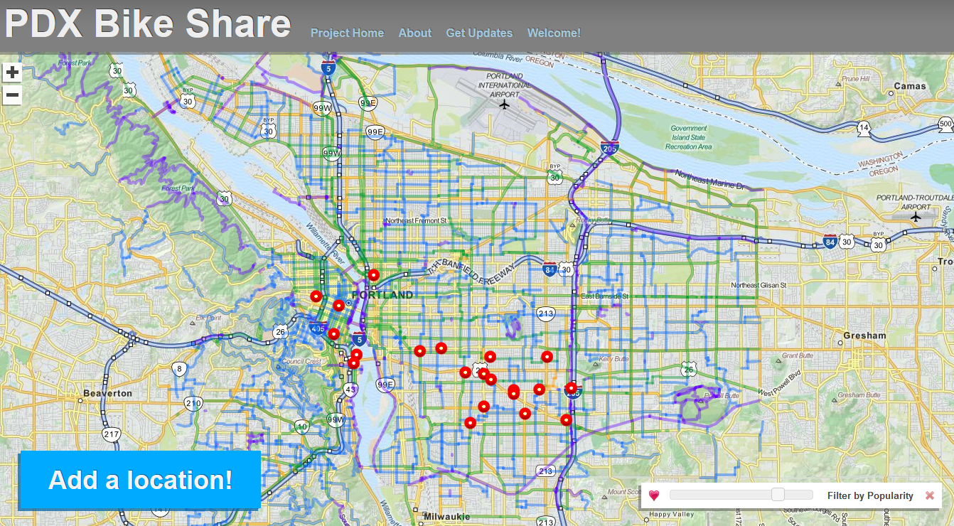
Here’s one final way to think about where bikeshare stations should go: the places where the city’s bikeshare station crowdsourcing tool shows that they’ve been most requested. Here are the top 20 most popular stations on the city’s website, all of which have received at least 40 votes:
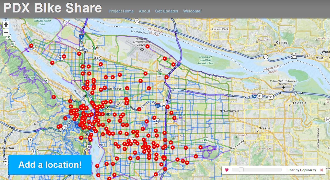
Or looking at it another way, here are all the stations that have received at least 10 votes:
The puzzle of which neighborhoods bikeshare should serve is a real one, but it isn’t unique to Portland. It isn’t even unique to bikesharing. It’s almost exactly the same as a longstanding tradeoff in the world of public transit: should we focus transit in the areas where ridership is the highest and requires the least subsidy, or in areas where ridership will be lower but there are fewer other ways to get around?
The more money the public is willing to spend to subsidize a system, the more that system is able to afford serving less-profitable areas. In the case of Portland bikeshare, our city agreed to use federal money to subsidize the startup cost, but not to cover the ongoing cost of the service.
In the public transit world, every community comes to a compromise between the two extremes, then continues to tweak that compromise on an ongoing basis. That’s what to expect when and if Portland bikeshare finally shows up.



Thanks for reading.
BikePortland has served this community with independent community journalism since 2005. We rely on subscriptions from readers like you to survive. Your financial support is vital in keeping this valuable resource alive and well.
Please subscribe today to strengthen and expand our work.
Good question. A buddy of mine and I asked the same one back in March then presented our findings to our GIS class.
Portland Bikeshare Hot Spots = http://j.mp/PdxBikeGIS
Sweet Prezi! Looks like your analysis came up with slightly different (and more widely distributed) results than Alta’s because you emphasized the presence of transit stops rather than their ridership, the number of businesses rather than the density of jobs, and the quality of bikeways rather than just street connectivity. Is that right?
Hi Michael,
Any chance you could cite sources directly in the captions of each of these maps? You refer to them some in the body of the story but it’s not quite clear what company/organization authored each.
I also notice some draft disclaimers and date stamps on the maps, some of which aren’t legible at the resolution you’ve posted. Do you have any insight on that? At the least, I’d guess that means we should take them with a grain of salt.
Thanks!
Sure thing, Elliot. The Cincinnati and Calgary maps are from this Alta report:
http://www.altaplanning.com/App_Content/files/Alta_BikeShare%20Planning%20Studies.pdf
The Nice Ride map, from 2010, is from this one:
https://www.niceridemn.org/_asset/rkl00c/CDG_Report_NiceRideMn-DRAFT_021610.pdf
The DC maps are from this report, as noted above:
http://rethinkcollegepark.net/blog/wp-content/uploads/2006/07/DaddioMP_Final-Draft.pdf
And the map at the very top and the second one in the post are both from recent reports linked at the bottom of this page:
http://www.katu.com/news/investigators/Lack-of-sponsors-may-force-city-to-bail-out-planned-bike-share-program-219692301.html
I think those two were provided to KATU by the City of Portland. I’ll add links above as appropriate.
EDIT: I also should have made clear that the Census data in the CLF maps was from 2010.
Hi Michael,
With the limited time frame that we had for this final mapping project, we really had to be choosy on certain elements to represent for the Bikeshare Hot Spots. We could have quickly fallen down the rabbit hole by including many other variables along with weights that would make the results even more realistic.
That being said, conjuring up coursework that was done 6 months ago has me recalling that we did emphasize transit locations, weighing certain factors higher than others. An example would be Transit Centers ranking highest with bus stops lowest. We also separated and weighed zoning features such as commercial, industrial and residential. Light business (commercial) held the most weight since those locations seem to be a place where bike share patrons would strongly want to visit. Connectivity was also represented whereas bicycle facilities were represented, counted for and weighted. Certain thoroughfares, such as Bike Boulevards scored the highest points whereas streets that had high traffic volumes and no bicycle access scored the least points.
Our method was not perfect but with more time, and maybe a GIS 2 course, we could probably put together something pretty substantial. But, this was a product that we were very pleased with and acceptable enough to earn us an “A”. 😉
Definitely didn’t mean to criticize this, Josh, just to clarify. It’s a terrific project and personally I think the methodology is solid (job density being the only major omission IMO).
No offense taken.
There is ALWAYS room for improvement in a project like this!
Hi Michael,
Your observations are spot-on about the differences between Alta’s criteria and the map we made. We didn’t consider ridership for our transit criteria, and we focused on business density instead of employment density. We considered both access to and quality of bikeways, but did not consider street connectivity. It also looks like we treated zoning and slope in a different way than Alta. As Josh mentioned, this was our first foray into GIS analysis, and was a great learning experience. Since I have the GIS files, I was able to get some more details about our project.
Our analysis considered 3 criteria categories, which were combined into a final composite score. Each of these criteria had a few different components, which were weighted and added to create an overall criteria score. The criteria were:
– Bike-friendly street access
– Land use intensity
– Distance to transit
Bike-friendly street access considered distance to the nearest multi-use paths, bike boulevards, bike lanes, and high traffic streets. Locations close to each of these street types received a high base score. The base score decreased until a location was further than 500m from the street, at which point it scored zero. A multiplier accounting for bike-friendliness was used for each base score (0.5 for multi-use paths, 0.3 for bike boulevards, 0.2 for bike lanes, and -0.1 for high traffic streets), and the scores were summed together for an overall “bike-friendly street access” score.
This score represented the immediate accessibility, quality, and diversity of bike infrastructure. However, it does not account for the connectivity or popularity of different parts of Portland’s bike network. Also, walking-network distance would be more accurate than straight-line distance.
Land use intensity considered business density, population density, and bike parking density as components. Business density was calculated from a subset of business license locations that we thought would appeal to bikeshare customers. I believe this included retail, food, and drink. We used population density from the 2010 census, and public bike parking locations provided by the city.
We used a similar weighting system to combine these scores. Each category was normalized by the highest score, then combined with a multiplier to account for relative influence. Business density and population density were weighted equally at 0.4, while bike parking was weighted 0.2.
This score recognizes that population density is important for a successful bikeshare system, and also incorporates the importance of destinations for bikeshare users though the business density. Though the included business density is also rough indicator for employment density, it neglects a significant amount of employment categories. Bike parking density was included as a proxy for local bike culture/enthusiasm.
Distance to transit was calculated similarly to the bike-friendly streets criteria. Straight-line distance to transit centers, light rail stations, and bus stops were used for the component scores. Transit centers were weighted 0.5, light rail at 0.3, and bus stops at 0.2.
This was a simple assessment of transit access. Frequency, ridership, and connectivity was not included.
Finally, we restricted the results to areas we thought had a ground slope and zoning suitable for a bikeshare station. We used 10% as the maximum slope, and included the following zoning designations: commercial, mixed use residential, multi-family housing, parks, and public open space.
Thanks for reading!
Nice Josh.
Do you have the final map in high resolution somewhere accessible?
Hi Tony,
Let’s see if this Dropbox link works for you. There are some mapping images you may find useful: https://www.dropbox.com/sh/3eg1ybd503zctui/0X55pCqBOh/Bikeshare%20Suitability%20Maps
Hi everyone,
Glad you’re enjoying our project maps! Here’s a link to high resolution versions of all the maps included in the prezi:
http://j.mp/PdxBikeGIS-Images
Great maps. I think it’s a sign of bike share’s strength that it’s the only form of transit in modern times that’s been able to be launched and sustained with private funds. I think that speaks to the popularity and strength of an idea whose time has come.
If TriMet stepped in and offered funding we could have a complete network right away, and not just in Portland. I think there should be bikeshare stations supporting the frequent service network of max and busses, greatly extending the walking range for each line (http://www.humantransit.org/2011/04/basics-walking-distance-to-transit.html)
My modest proposal: Take the subsidy Portland Streetcar gets and give it to bikeshare instead.
You’re right, if I had a transit line that gets more weekday ridership than all but FIVE bus lines metrowide (and more ridership per revenue hour than all of them), I’d want to cut it too! *headdesk*
http://portlandafoot.org/w/2012_TriMet_bus_rankings
It’s not a transit line, as even its biggest supporters will tell you. Transit money should be spent on actual transit, like bikeshare.
Sorry, despite what the City thinks or what the blogosphere echo chamber tells you, people in Northwest, Downtown, and South Waterfront (you know, the neighborhoods with real density in this city) actually use the line to commute to work or PSU. I know, mind-blowing, right?
For lack of any other option. I, too, used to use it to commute to PSU. Do you really think the N/S line will have higher ridersip than the 6? The streetcar isn’t as wise a use of our dollars as bike share. Since it seems like Alta is having a hard time coming up with money for bikeshare I propose taking it from one of the most costly forms of transit we have and putting it into something better.
The City’s map is logical. You need to have a critical mass of stations in the Central City to make the system a success. Placing them too far to the east without having enough docks downtown is bound to create capacity issues, as well as require constant rebalancing to account for commuter travel. If there aren’t enough stations close to your destination downtown, it would make docking a total hassle. So while there would be no place to park your bike downtown during the daytime, all of the Eastside racks would be deserted. Reverse that for the evening hours.
Placing stations for the sake of coverage rather than maximizing density is usually done out of politics and is a good recipe to making sure the stations go unused. The issues with Capital Bikeshare east of the Anacostia River in DC provides a good example of that.
On another note, placing four stations on 28th Avenue between Stark and Broadway is bound to bring the bike access issues there to the forefront.
Seems like a tricky problem, with many angles.
Presumably the system is for tourists and for residents who don’t always ride their bike already (or drive today). Stations need to be at spots where people want/need to go, but also at a variety of starting points around town. I think it makes sense to try to hook up with MAX and bus line points around town. What about the bike boulevards – would it make sense to have more stations also oriented to those roads (as opposed to the main streets like Belmont and Hawthorne)? Particularly where the boulevards cross MAX/bus lines.
Coverage seems light in the N. Mississippi area in Phase 1.
You put the bike share stations where people want to go. The vast majority of users are going to destinations on the commercial corridors, not on the bike boulevards.
I understand that people want to end up on the commercial strips – but I also think that in some of those areas the safety is not that great for riders. Maybe at least think about how to point riders to the nearest boulevard…
I understand the practical reasons for putting the bike stations in the
richest areas that already get all the attention, and not making any firm commitment to servings Saint Johns, or Lents, or Gateway.
But, since starting a bike share system and equity are not compatible in this plan, there is a strong case for not using any public funds on the first phase of the project. Perhaps David Evans and Associates, or United Streetcar, or Urban Design Group and all the other businesses that has prospered due to “smart growth” can chip in to pay for the first phase of bike share.
If money was diverted from the street car to bike share, that would be fair because the street car doesn’t help anyone who doesn’t live close-in.
Once the program is shown to work, I would support some public funds to build out the system to the neglected neighborhoods, despite my concerns about Alta and its’ relationship with City Hall.
Im sorry, whats preventing someone “who doesnt live close in” from riding the streetcar? People are known on occasion to travel outside their neighborhood.
The streetcar is of little benefit outside of the central city.
Bikeshare really only works for shorter distances, a few miles at best. If you go over 30 minutes, you start getting charged, with the charges increasing based on a exponential curve. IE, if you are going to commute by bike, buy your own. If you happen to be in an area without a bike and need to puddle-jump, this offers a good opportunity to hop on a bike.
As a result, the simple geometry of density mandates that the stations be where the people are. Low-density areas will likely cause the entire system to fail financially, if they do not serve the most lucrative and busiest destinations. Lents compared to downtown probably has 1/1000th the daytime population…
Equity has nothing to do with it. You can have your equity debate when we look at expanding the system. This is about station placement. The only thing that matters is usage: where the bikes will get used the most. Factoring in “equity” will only diminish the value and success of the system.
Equity doesn’t matter if no city funds go into the bike share.
If tax money from the neglected neighborhoods goes into bike share- then
“wishing won’t make it so”- you will have a major equity issue.
As a Brooklyn resident I’m disappointed that even Phase 2 doesn’t include a single station south of Clinton street.
We have a new TriMet line opening up here in late 2015, which coincides with the earliest date we could reasonably expect phase 2 to occur. At an absolute minimum, why wouldn’t there be BikeShare stations at the Rhine, Holgate and Bybee MAX stations?
And why wouldn’t there also be one at Reed College, which would allow students there to better connect with MAX? This would be especially useful since TriMet snubbed Woodstock/Reed by cutting the Harold Street station and overpass from the project.
I’m also a little surprised the phase 2 stations would be clustered quite so tightly together. In the Twin Cities’ second phase (which I enjoyed using a couple months ago, and would have found a lot less useful in its phase 1 iteration), the furthest southeast station is 18 miles away from the furthest northwest station. In Portland, the greatest distance between any two phase 2 stations is only 7 miles. I know Portland is a lot more compact, but this seems disproportionately scaled-down, and pushes a number of Portland’s bikey neighborhoods out to Phase 3 (assuming phase 3 even happens).
Nice Ride is so spread out because it spans two cities. I wouldn’t consider it a relevant comparison unless Portland and Vancouver start considering a shared system.
As long as we’re talking about density, the distance between the two furthest stations across all 400+ stations and 7,000 bikes in the New York Citi Bike system is less than 7 miles. As you point out, Portland’s proposed 75 station system is covering roughly the same geographic area. In that light, proposing to stretch the Portland system even thinner across decreasingly dense residential neighborhoods seems… ambitious.
And NYC is significantly more dense than Portland, (and apparently they’re waiting for further expansion), so I don’t really see your comparison? Are you saying we should stay even more compact because we’re less dense? To me less dense means a need for expansion. Minneapolis is a fine comparison, as they have plenty of far reaching stations not headed directly for St. Paul.
1. OK, let’s exclude St. Paul. We’re still talking 13 miles between stations, even within Minneapolis.
2. Vancouver’s relationship with Portland (geographically, politically and economically) is not remotely analogous to that of St. Paul’s with Minneapolis.
3. The areas I’m proposing to include in Phase 2 aren’t particularly “decreasingly dense” neighborhoods from a number of others in the current Phase 2 proposal. In terms of either population density or current intensity of bike usage. What I am proposing that the density of BikeShare Stations in the Phase 2 zone be reduced somewhat so that more of Portland’s already bike-friendly neighborhoods can be included in this overly tight proposal.
4. Davemess is right about the NYC comparison, and that NYC’s much greater density lends itself to a more compact solution (which, BTW, is still in phase 1, not 2). That reasoning might also call for Portland to have a slightly more compact system than Minneapolis, but not by anywhere near the degree seen in this proposal.
Nobody lives south of Division, don’t you know that?
I agree as an outer SE resident even the phase 2 does not go remotely far enough out. I also have ridden Minneapolis’ nice ride, and it was great how far the stations actually went. I could tour further parts of the city easily. Their stations almost go the entire way to the airport, which I thought was a great idea.
It seemed to me that Minneapolis’ bike share seemed a bit at odds with their public transit, as there seemed to be little cross over in signage and maps. This was really disappointing as I know that they are kind of competing with each other for customers, but they can easily be used in combination for great transportation access. Here’s to hoping we do a better job and get TriMet on board. There is absolutely no reason that stations should not be right next to many MAX stops and transit centers.
Believe it or not, most people in Portland go to Central City whether they live there or not, Central City is where the density and destinations are and is the most walkable. The blind anti-downtown rhetoric that is so popular now completely ignores that downtown IS a unique crossroads location for everyone. Leave it to Portland to be the only failed bike share city because it located stations for political reasons not for logical reasons.
being the “most walkable” though does not mean that it needs quite as many bike share stations. I”m not saying don’t put stations downtown, but it seems like the potential stations locations are just going to discourage a lot of Portlanders from using the system.
I think we need to get away from thinking of the central city as some kind of, umm, Elysium that the vast majority of us don’t visit in some way (and Jonathan’s story gets at this). Rich and poor, we travel to the central city for work, education, healthcare, et al. My only concern is actually for the out-of-towners who we want to help fund this service and who we want to leave Portland thinking it’s an a great town to bike. It’s already been noted here and elsewhere that the most pleasant biking experience is on the east side. Lookin forward to that Phase 2.
What is the factual basis for your assertion? Do you live in outer SE?
The neglect on the part of the city is outrageous. I live between
close-in and outer SE, and I am tired of unequal treatment. Do you think
the current plan is fair enough to merit someone in Gateway paying for it?
I live less than 20 blocks from 82nd ave in a neighborhood that according to two of the above maps has a higher density of people of color and the poor. And I used to live in low income housing downtown around a lot more low income people than I do now. Which doesn’t make my opinion more qualified than anyone else’s but you asked. I get your complaint about Gateway and I agree it needs more funding (and I said I was looking forward to bikeshare moving east). I’m not sure what ‘densely urban areas are densely urban’ warrants a sourcing of facts?
I think she wants some sources for your initial claim that we all travel to the central city on a consistent basis. For many in East Portland this just isn’t true.
Thanks, Dave! That was my point.
I never said we all travel to the central city. I’m simply pointing out that more people travel to the central city than any other square mile in Portland. I want to generally respect a plurality of opinions but on that simple point it isn’t my opinion. And if we’re all reading the same article, I don’t need to “source” it. I’m commenting on an article that illustrates this very point in map 2: http://bikeportland.org/wp-content/uploads/2013/08/portland-bikeshare-suitability.png Or you can go up to Council Crest and point at the tallest buildings. There’s more stuff downtown. I kindly submit that not everything on the Internet is worth a debate.
Looking at the crowdsourcing tool, it’s clear to me that there’s a southeast hub that doesn’t require trips to start and end downtown. It’s the 20-minute neighborhood idea that lets people take short trips to stores, bars, MAX, food carts, etc. In this sense, the gradual expansion doesn’t make as much sense as does looking at these hubs.
“Rich and poor, we travel to the central city for work, education, healthcare, et al.”
The central city is simply not on my map as a destination. At best its a part of portland I travel through to get to areas of interest.
Sure, that’s your experience but if more people had your daily travel experience, wherever that is would necessarily have the taller buildings and would thus have more destinations and a greater demand for a service like bikeshare.
It would be a public relations nightmare….and a feeding frenzy for the anti-bike crowd if the city funds this with public money even if it is a loan. The remaining 2.6 million needs to come from the private sector.
Starting in the dense neiborhoods is fine, but the phase two and three plans need to be MUCH more equitable if this is going to gain any long term traction for anyone other than tourists. We already have a much higher bike mode split than any of these other example cities. Hence, I am afraid that is may not int the end be economically viable and the city should not put itself at financial risk.
Wait, wouldn’t having a bike mode split of 6% rather than 1% probably make us a better market for bike share? There’s still 94% of the population left who could theoretically use bike share rather than their own bikes and the 6% mode share means biking at all is more mainstream here. Probably also more comfortable than say NYC or DC due to fewer / less aggressive drivers.
True about drivers having more respect for cyclists here. A friend of mine was here for a two week visit and was AMAZED at how “well trained our civilian fleet is” (he drives for Union Cab) as far as stopping for crosswalks and bikeway crossings.
That said, my most important point is that there are already so many bikes, and so many people with extra bikes, that for locals this is going to be something of an oddity for tourists…like the streetcar to most of us that do not live downtown anymore. If your goal is to increase mode share in the GENERAL public, this is not going to do it much. Most people who want to learn, borrow a bike from a friend first or can find one cheaply.
Hence, since local public money should go to increasing local bike mode share this is not the place for PBOT investment. If the business community wants to come together, as they should, and sponsor bike-share to keep more cars (mostly rentals probably) out of downtown and encourage tourists to use them I am all for it. But in these days of self-imposed austerity PBOT should not finance it.
If we were a city that actually charges for parking, public auto storage, or tolled access into downtown my reaction would be completely different I am sure.
The station locations around Foster & Powell have got to be a joke. Foster and 82nd the most popular site for bike rentals? Really?
Must be ironic hipster-internet voting day.
That’s true; there clearly would be no people interested at an intersection of two of the busier streets in the city….. Foster is in the planning process of hopefully getting bike lanes, why not take advantage of them by giving people bike share access? What about people who may want to shoot over to Fred Meyer from the MAX and would like a bike for the mile ride? Just because this intersection isn’t a biking mecca now doesn’t mean it couldn’t utilize bike share.
Have you been to Foster-Powell? More and more bikes every day despite mediocre at best infrastructure. Notice where many of those top 20 dots are located, mid-outer SE. The top draft plan map should really take this into account.
Look its a map of where rich white people live.
Uhh the two maps third and fourth from the end make it clear that downtown (where most of the phase 1 stations are proposed) actually has an unusually high percentage of non-rich and non-white people.
Phase 2 does seem to be focused in areas that are more white and wealthy than average but that’s still a good ways away.
You need a credit card to use a bike share bike, right? So theable-bodied poor are out.
Agreed that there is some subsidized rentals downtown- but are those residents your target group? Are we pointing bike share at the elderly and disabled who live in the subsidized places?
The working poor are in outer NE & SE. But the bike evangelists live close-in, and close-in always gets the resources that the builders and bike evangelists want.
I would hope that Portland would implement from the start the credit-card waiver for low-income folks that’s been piloted in DC. Also, given that the federal funding (which is all the public money for the system at this point) is for transportation equity, we need to keep pressure on PBOT to make this an equitable project. I have high hopes that they will make this program non just accessible to low-income folks, but indeed targeted to them. More on how they could do that in a below comment….
Have you ever BEEN downtown? Have you looked around at the people who live there? Sure, there are some wealthy, and a few middle class, but there are a lot of poor people. Look at where all of the subsidized housing is. There is a LOT of it along SW 10th, 11th, and 12th.
Alex who do you think will be taking trips on bikes downtown- the non-rich folks or the loft dwellers? This is a huge tax expendeture on people who already have made it. This money would be far better spent on better infrastructure in outer SE and N Portland.
Yes I have been downtown, my son went to school there for years, but I lived in outer SE Portland and if you think there are a lot of non-rich, non-white people downtown you should head out to 102nd and Powell and get your world rocked. Those are the places that need investments in bike infrastructure not downtown that aready has bike lanes, sharrows, bike paths…
Hopefully disproportionately the non-rich folks! The federal funding for this program is explicitly aimed at transportation equity, so I will have very high expectations that PBOT make this program not only accessible to non-rich folks, but indeed targeted to them. Ideas I have that could help with this:
A) Bikeshare stations put disproportionately right in front of affordable housing (including not just official government-enrolled “Affordable Housing” but also the cheaper end of market-rate housing such as older apartment buildings with no parking and small units) and homeless shelters.
B) Low-income waivers of the credit card requirement (as has been piloted in DC) being heavily promoted. I would want to see sign-up tables in front of affordable housing, homeless shelters, and other targeted destinations frequently.
C) Outreach to caseworkers and other professionals who help disproportionately low-income folks in the area so they know about the program and can promote it to their clients.
If PBOT doesn’t take targeting steps like this or others, it will probably make the program a middle-to-high-earner commuter-focused transportation system. Not the end of the world, but a significant betrayal of the intention of the federal funding and something that would add to the already significant distrust of PBOT and the Portland political establishment.
Agreed that East Portland needs bike investment more, but I suspect that for whatever reason, the “sexy” bikeshare idea (which works with a lot less ongoing subsidy downtown due to more trips per bike) was more likely to get the particular federal funds used in this instance than workaday (yet crucial) bike infrastructure in East Portland. If somebody knows the specifics about this funding source, please clarify/correct me!
The tradeoff in this particular case was basically sidewalks in SE/SW, or bikeshare. You can read the “robust public process” link above for more background, or follow it here:
http://portlandafoot.org/2011/08/why-pdxs-equity-advocates-agreed-to-back-bikesharing-deal/
Thanks Michael! Interesting. I guess I forgot that bikeshare funding displaced infrastructure improvements in underserved areas, lame! According to my particular policy preferences, sidewalks in sidewalk-less areas are more important than central city bikeshare, but maybe you get so much bikeshare for the federal money given add-on private funding that funding bikeshare instead was a good idea? Maybe?
Well, I guess that ship has sailed. More sidewalks though please!
Seems likely the late-night crowd will also keep the funded and moving along… http://www.nytimes.com/2013/08/22/fashion/riding-away-from-a-bar-crawl-with-citi-bikes.html?partner=rss&emc=rss&smid=tw-nytimes
Honestly, who the heck needs bike share in Portland? Almost all hipsters have a fixie. The few tourists that do come here go to the wineries, have not seen many of them biking to the zoo or the museum. When the share bikes come, I sure hope the seats are welded to the frames – my current seat on my WalMart bike chafes my tush! Then the city needs to buy trucks and hire people to relocate/restock bikes to empty holders – they do that in NY daily. And at night a drunk a-hole can take out an entire rack of them with his SUV.
By the way, they found some Velib bikes from Paris in North Africa and Ukraine! Looking for that $100 rattle can painted share bike out there in Idaho soon.
And this folks is why you shouldn’t post after midnight……