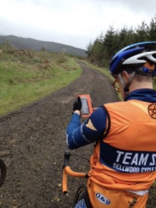
(Photos: Judd Eustice)
Semi-organized, unsanctioned rides on a mix of gravel and paved roads are increasingly popular these days. There were three in the Portland area last weekend alone. One of the reasons people love these rides is the sense of adventure they afford. There are no markings or course officials. Riders are on their own except for the friends they bring or make. BikePortland contributor Judd Eustice tackled the Scappoose Soul Slaughterer yesterday and ended up getting lost. In the process, he had more fun than he ever expected. When he got home (after a shower and some food of course) he typed up a stream-of-consciousness recap in an email to me. He planned to clean it up before I posted it; but I thought it was fun to read in its original form. Hope you do too. — Jonathan
—
It was a bit of a mess from the start.
There were perhaps a dozen of us that showed up. A large contingent were from Team S&M and/or Sellwood Cycle. Mike, the organizer of the Slaughterer, showed up with multiple contusions all over his face from hitting the pavement on his bike after a night out. He wouldn’t be riding. Not many of us, if any, printed out the cue sheet and only a couple of us had the GPS file on our Garmins. However, they weren’t doing us much good. A local rider, James Ogbert, who works at Chris King, started leading us out and it was my understanding at the time that he had helped out on the planning. I caught up with my teammates, Aaron and Michael and we were up front with James.

(Coalition Racing Development)
At an intersection, we realized that the rest of the group wasn’t with us any longer. After a long wait, we assumed they had taken a turn off somewhere and we kept going. We started riding up the Banks-Vernonia trail and it was beautiful with its lush rainforest growth and rolling gravel. I felt it was ideal for this type of riding. However, I also felt it was too ideal. Mike had bragged about how hard this course was and how the first 20 miles would take about 2.5 hours. This wasn’t that hard. He had also said that I was going to hate him about 45 minutes after we started due to the wicked nature of the course. I was beginning to praise him for the choice of the route and I knew that couldn’t be right. Not Mike. Something was wrong.
James couldn’t ride too much on the hills due to a torn MCL he was recovering from and when the trail met the highway, James bid us adieu and we thanked him for his help. But now we didn’t really know where we were headed. We had a general idea and followed the trail downward in relatively smooth fashion through the forest, listening to the calls and tweets of the birds like cheering fans as we raced along.
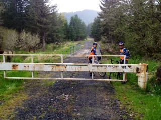
We came to a highway that was empty of cars but rolled along and all we saw as far as traffic on this Sunday morning were other riders on time trial bikes, obviously not on the Slaughterer. We asked one for some direction as to finding our way and he pointed out the gate on the side of the road several miles down that was a timber road that led to Vernonia. We carried our bikes over the gated barrier and proceeded up the hill on a road that was about as good as you can get for a working timber area.
As we made our way up the hills, the wear and tear of the previous days Ronde ride and my lack of sleep from the previous night began to catch up to me a bit. I let Mike and Aaron take off while I conserved my strength and found them waiting for me, which is not the way I like to find myself, pulling up the rear. But they were gracious and we kept going and moved through some gorgeous forest land with areas of clear cut that opened up vistas for us to gaze at. Unfortunately, the vistas were clouded over and the rain started sprinkling and the wind seemed just a little colder. We started to move down off the mountain.
“We all agreed that we were probably lost from the Slaughterer route, but we didn’t care.”
For anyone who has ridden one of these gravel grinders knows, the roads are very often poorly and/or cryptically marked and without proper navigation tools, it becomes a lot of guesswork and often the guessing is wrong. We almost had that. Our Garmins were worthless as providing any help. But our iPhones had service! We pulled up Google Maps and it pinpointed where we were and even gave us road names. Great! A long, winding mistake was almost made when we didn’t flip the phone upside down to orient us in the direction of north. Luckily, we double-checked. Sure of our way, we flew down the rocky descents and it was the most incredible riding. The views were amazing, the sounds of birds was music and the sight of a large buck sprinting across the trail was just the type of surprise that I look for when I ride. My friends and I were in heaven.
We all agreed that we were probably lost from the Slaughterer route, but we didn’t care. We were having a blast. That’s all that counted. Mike had led us out of our urban neighborhoods and pointed the way to some supreme riding that led us to the discovery that we needed more of this. We were away from the mundane routes that we ride every Sunday. We faced a little bit of uncertainty and made the ride all that more adventurous. We felt free and our conditioning was carrying us through the difficulty of the adventure.
We finally got down to Vernonia and we were faced with a choice of taking the road (Highway 47) back to Scappoose or going back over the trails in the timber area and not knowing where we were really headed. Google maps pointed out that there would be many twists and turns that would slow us down, as we would have to stop at each intersection and re-orient ourselves before heading forward. Then the rain really started. None of us were prepared for this. All the weather reports seemed favorable and we were under-dressed. So we took the highway. 20 miles back to Scappoose. Again, what a lovely ride, other than the cold rain. We loved it! The rolling hills, the lack of heavy traffic and the forested canopy made it exceptional.
This won’t be the last time we make our way out there. In fact, we’ll probably go back next week.



Thanks for reading.
BikePortland has served this community with independent community journalism since 2005. We rely on subscriptions from readers like you to survive. Your financial support is vital in keeping this valuable resource alive and well.
Please subscribe today to strengthen and expand our work.
A couple points for the author’s edification:
* The Banks-Vernonia trail is entirely paved. There is no gravel of any kind on it, rolling or otherwise. It also goes from Banks to Vernonia (as you would guess from the name) and doesn’t get any closer to Scappoose than Vernonia. From your pictures, it looks like you were on the old Crown-Zellerbach mainline logging road, which they have converted into a gravel multi-use path, and which goes west from Scappoose to the highway just north of Vernonia.
* Highway 47 does not go from Vernonia to Scappoose. It goes from McMinnville to Forest Grove to Vernonia to Clatskanie. If you took a paved highway from Vernonia to Scappoose, it was the Scappoose-Vernonia Highway (aka Scaponia Road.) Coming out of Vernonia, it is true that you would have spent a couple miles on OR 47 until the junction with Scappoose-Vernonia Highway at Pittsburg.
Thanks Michael! I’m sure Judd will appreciate your insights. And great to hear from you after all these years. And if anyone doubts Mr. Wolfe’s credibility on these matters, please check a post I did about him back in 2006; Michael Wolfe helps us escape the city. Oh, and I also sat down with him in 2007 before he left to compete in the Paris-Brest-Paris Grand Randonnée.
Plus the awesome blog Michael used to maintain, which has a bunch of awesome routes that take off from Portland. I’ll let you decide if they are single day rides!!
http://escapevelocipede.blogspot.com/
The ride did start from the Crown Zellerbach trail, but I think he is referring just to the Scappoose-Vernonia hwy? We turned off the Crown-Zellerbach trail and onto the hwy before making a right up into the hills. We all passed the turn off initially and some stayed back and we tried to yell up to those who were continuing on the Hwy in the wrong direction, but these few guys didn’t hear us and continued onward.
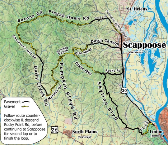
The bulk of the group ended up doing the entire loop or most of it. Nearly all of us did bring cue sheets, but the cue sheets were lacking in enough detail to catch all of the turns on unmarked logging roads.
We had one guy with the gpx loaded on his garmin as our fearless leader and we regrouped at every turn, making for a large amount of stopped time.
The first few miles did indeed have about 2k feet of climbing before turning into the large, rocky portion of the ride. The rain began just as we headed out of the first section of large rocks.
The “60 mile loop” was only 45 miles. It took 9 hours total to ride from portland, start the ride, finish the loop, and ride home, including stoppign time. Quite the adventure but many about 10 of us did the entire loop, with 3 sellwood guys doing most of the loop before cutting back through North Plains.
They missed out on the second gravel section of Murphy, Pumpkin Ridge/Smokie ranch, and Dixie Mtn.
This is cycling at it’s best. Friends, a loose plan and enough juice in the legs to get you in trouble and back out again. I also love this area to ride in. Good stuff. Thanks for sharing.
I have forever wanted to know of a loop ride that would avoid Hwy 30 completely. Some road/path that connects Otto Miller to Pisgah. Anyone know if there is a way to do this?
Dutch Canyon Road:
http://goo.gl/maps/c9kGD
Thank you Joseph! I had overlooked that route!
Reads like the driver that took a wrong turn and ended up on the i205 path’…getting lost is part of the fun’.
So for those of you who managed the entire route, how was the road conditions? I.E. Manageable with 33mm xc tires, or? I ask as I want to take my wife and the tandem on this route. Before anyone panic’s, We regularly ride leif errickson and occasionally, descend the (bike permitted) fire trails with little trouble.
Also, I ride my road-frame with tiny 23mm slicks through saltzman all the time w/o any trouble.
There are a few rocky sections that are difficult to navigate on 32s, anything smaller will make for a very long day.
I rode it with fairly skinny 32s (continental top touring). I wouldn’t recommend it on a tandem. the route contains some very large rocks and takes some skill navigating them, which would be a little harder for two to do simultaneously.
So my wife and I took up the challenge laid down before us today. Wow, that was a lot of fun! I am glad to say that the forest service – rocks roads were the least of our challenges.
The biggest challenge was keeping our glucose levels up, and running out of water in this surprising 85′ weather we had today. The other issue was descending the various roads that were hard-pack with loose gravel over-top.
http://app.strava.com/activities/50727715
For those who want to take this on, I do recommend running your tires wide (33mm +) and low pressure. The trick to the rock section is to keep your speed up / power through the sections.
I love cruising the old dirt roads, though my outlook seems to be different from most. I did the VeloDirt Dalles Mountain 60 a few weeks ago, and although the ride was spectacular the field was dominated by (at least compared to me) racer-types and I found myself quickly dropped by almost everybody (I’m a slow climber).
But it was a beautiful spring day in beautiful country, and I quickly realized I was better off pootling along at my own pace, without the rest of them anyway. Other than a couple of flats and having to ride the Biggs Bridge without the safety of numbers (which, ironically, was the main reason I’d started out with the group anyway), I enjoyed the ride immensely.
I’ve been meaning to get out to the area described on this thread and do more exploring. Also been meaning to use the Crown Zellerbach Trail from Vernonia as a way to ride home after a night of camping at Stub Stewart (unlike apparently many, I don’t mind Hwy 30 with its tailwind and wide shoulders).