TriMet has announced that the Eastbank Esplanade bicycling and walking path just south of OMSI to SE Caruthers Street will be closed for 14 months. The closure is due to construction of the Portland-Milwaukie Light Rail bridge. Here’s more from TriMet:
Two contractors, Kiewit and Stacy Witbeck, will be working in the closure area to move and rebuild a portion of the Eastside Greenway Trail, build walls and construct the landside piers and abutment for the Portland-Milwaukie Light Rail transit bridge.
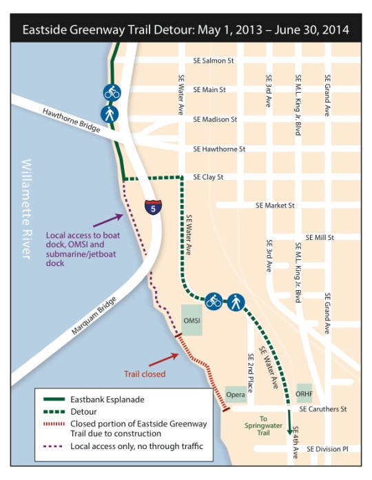
During the trail closure, pedestrians and cyclists will be detoured to SE Water Avenue which has new sidewalks and bike lanes and connects directly to SE 4th Avenue and the Springwater Corridor Trail.
There will be signs placed on the Eastside Greenway Trail at the end of this week to notify trail users well in advance of the closure/detour.In May, full directional/informational signage will be placed at the trail closure points and along the detour to help trail users find their way.
And here’s a map of the detour:


Thanks for reading.
BikePortland has served this community with independent community journalism since 2005. We rely on subscriptions from readers like you to survive. Your financial support is vital in keeping this valuable resource alive and well.
Please subscribe today to strengthen and expand our work.
This detour is actually pretty darn convenient still. Less scenic though.
yeah, I figured that was coming. Thankfully the detour is not too big of a deal. They’ve closed off that section of the east bank before due to construction.
Just in time for summer!
But in all seriousness, maybe this detour should be the new, permanent alignment for this route. The two trails are forever connected by surface streets, so the only major difference it makes is a positive: no more sludgy mix of cross/through traffic along OMSI.
Its all good…..we are getting an awesome new bridge and connection to the south waterfront. A little detour is a small price to pay.
I’ve been using this detour as my main route since they re-opened Water Ave. Nice new asphalt, no little kids darting about. What’s not to like?
I’ve been riding both routes recently. I don’t like the turn at Clay St. I’ve tried merging out into traffic and taking a left at the signal, that’s a bit nerve wracking when cars don’t let me over. What’s it going to be like in the summer when we get some real bike traffic through there in the mornings?
I am wondering what you mean by “when cars wont let you over” ?
Here’s the area I have problems with: http://goo.gl/maps/HbzNS
I try to go from the bike lane, across the right turn lane, then move left out of the bike lane into the far left of the thru/left? travel lane. Drivers aren’t always so keen to 1) stop for me when they want to cross the bike lane for their right turn and 2) let me into their lane to turn left to the waterfront. Maybe I’m doing something wrong?
Maybe try taking the lane before the right lane merge appears? It would be an awesome place for a bike left turn lane like they installed off the Morrison at Yamhill. A lot of folks turn left inot the parking lot just before that light and pick up the sidewalk, or near OMSI and ride through the north end of that lot, you avoid the peds at the South end of the lot.
Thought about ti a bit more, additional thoughts further down the comment thread.
There are basically two options there. The first, which I’d tend towards, is to take the lane approaching the intersection and wait for an opening in the opposing lane at the light. The second is to pull onto the sidewalk at either crosswalk, which is probably the more sensible option given that you’re turning onto a multi-use path, and making a left turn that automobiles can’t make. Making that left from the bike lane, on the other hand, is dangerous and probably illegal.
In any case, I tend to take third and make the left onto Clay to avoid that situation altogether.
I hope the planned signage includes a ‘Bikes Yield To Oncoming Traffic’ sign for cyclists heading West onto Clay from Water.
Having 20 bike commuters bunched up waiting to turn onto a sidewalk in what looks like a no turns traffic lane on Water Ave. is just one of the bad things about this intersection.
that intersection at clay may need to be modified, but I understand if it would cost too much to make it safer.
Everyone start your stopwatches for the duration the detour is actually in place.
Folks — there’s a serious engineering deficiency and safety risk on the Clay St. connecting path — two sets of bollards, both of which are substandard. (“Bollards” are those posts that keep cars from driving onto paths)
If all the Esplenede traffic is diverted on the Clay St. Path, folks will have difficulty negotiating the squiggles through the bollards. Some will crash, some will break bones.
I’ve made a request to the Portland Transportation Safety Hotline once about these, and a rider on the AROW “Transport Your Activism” ride last summer did the same, yet the bollards are still there.
Help us all out — send in an email complaint and ask that they fix these bollards ASAP before the increase in traffic occurs.
Here’s what you do:
send an email to safe@portlandoregon.gov
Subject line: Please fix the bollards on the SE Clay St. Path between the Willamette River and SE Water St.
Message:
The bollards are improperly located, and are a hazard to bicycle and pedestrian navigation. Can you please remove these bollards, or reconstruct them to the standards found in the Oregon Bicycle and Pedestrian Plan,
Specifically:
* maintain a 5′ minimum width between the bollards
* configure the bollards so there is a single bollard in the middle of the path, or an even number of openings (to reduce head-on conflicts)
* set bollards back 20′ from intersections
* paint them a bright color with reflective markings for visibility
* paint a striped “envelope” around the bollard on the pavement
* consider using flexible bollards, rather than steel bollards
* install stop signs on the minor streets crossing the path
— all cited from (OBPP p. 7-15 – 7-16, 7-11)
ftp://ftp.odot.state.or.us/techserv/roadway/web_drawings/HDM/Appendix_N_BikePedDesignGuide_Web.pdf
Ted Buehler
Also, the width of the path is substandard, 12′ width is the “suggested path width” in high-use areas. p. 7-6
Couldn’t one also go through the OMSI parking lot south of Clay?
You can, but it’s a busy lot in the summer, and the end near the main OMSI building is just as busy as the esplanade with people traffic. People do it, it is a work around, but I think it a lot of people start doing it it will become a nuance or hazard as the lot is not designed for it.
It is worth noting that one can pick up the Esplanade from several other entry points north of Clay. It might be easier to take a left at Hawthorne, Main, Salmon or Madison.
There is a SE 4th Ave.? You learn something new every day.
Don’t turn at Clay. Proceed down Water Ave and take one of the other left hand turns that cut over to the river.
This is a perfect example of why I feel so lucky to live here: anywhere else there would be no consideration given to the needs of people on bikes during construction like this, much less a formal detour.
Moreover, when the construction is over it will result in a massively improved experience for cyclists.
WOW, just rode the new Water Avenue “detour” this morning. But now, it’s super wide and will be a very nice detour, especially once the bike lanes are striped.
Over the fast few years, this street and 2nd Place have variously been open and closed, had bike lanes and not had bike lanes. Car traffic through there is relatively sparse but relatively “angry” from cut-throughs fleeing traffic congestion elsewhere. In other words, at times I’ve found it a sometimes less-than-pleasant place to ride, and I would still take the waterfront path despite that route’s own hazards. With the latest iteration I’ll have no complaints about the detour.
I agree that the left turn onto the path at Clay can be tricky, but in practice I haven’t had any problems. That light is on a pretty short cycle, so even if there is oncoming traffic you rarely have to wait long for a red light. Once you find yourself there on the red and left-turning traffic (if any) from Clay has cleared, you can just turn left into the crosswalk inches in front of you, and enter the path well before there’s any chance of conflicting with oncoming cars.
I do agree with Ted about the bollards, and those have always irritated me even though I couldn’t necessarily say why. Thanks for quoting the standards.
Even worse, the bollards right at Water Ave are painted a fairly dull color and have NO reflective striping to make them visible at night. I can guarantee you someone will ride into these sometime this winter when it’s dark and rainy and there’s lots of glare from the cars on Water they’re trying to avoid. At least the (nonstandard) bollards further on in the parking lot have strips of reflective tape, just a 2″ DOT strip around the top but a LOT better than nothing.
Turning left onto the esplanade when northbound on Water is a hassle for sure. There’s not a particularly good place to do it. With such a long closure of this section of the esplanade, a left turn signal for bikes at Clay would be a good idea.
For those who want to skip the left turn (and the crowds on the esplanade), Water Ave is actually pretty convenient & safe (there’s a bike lane); it’s part of my preferred route north from the OMSI area to the Rose Quarter.
To the other comments about Clay not being the best place to turn left, that may be true of the Esplanade is your destination. But if your destination is downtown via the Hawthorne (as appears to be the case with at least 50% of the people I see on the path by OMSI in the morning), then Clay is probably your way.
Still, I’ll try turning left at Madison instead later this week and come at the Hawthorne on-ramp from the north. Maybe that will work well too.
I don;t know if anyone is still following this article, but I just got word at work (I wok on SE Water) that they will be putting in a bike box at SE Water and Clay for that left turn. Rad! It’s been needed for ages. http://www.trimet.org/pm/construction/#east
hmm the email said the info was on that site but I don”t see it yet. This was in the email as well as an image of the bike box.
“For cyclists:
There will be a permanent left turn bike box installed at the NE corner of SE Water Avenue and SE Clay Street.
A graphic of what this bike box will look like is attached to this email (Left_Turn_Bike_Box.pdf).
There will be a bike detection system incorporated into the traffic signal at this location as well.
The normal bike box treatment will apply – green background and white thermoplastic outline/text/graphic.
Also, the bollards between SE Water Avenue and the East Greenway Trail have been banded with white reflective tape to make them more visible for pedestrians and cyclists.”