As we enter the rainy season, a 100-foot section of the Springwater Corridor Trail that eroded away back in March, remains closed. So far, Portland Parks & Recreation has not begun work to shore up the Willamette riverbank below or repair the path; but yesterday, spokesman Mark Ross said we can expect a fix by the end of the year.
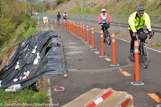
The impacted section of the path is a very busy section about one mile south of OMSI. The path is only about 10-12 feet wide in that section and the damage (referred to as a “trail failure”) has resulted in about half of it being closed. That leaves only one, relatively narrow lane that serves a significant amount of two-way walking and bicycling traffic.
“The project, an unforeseen emergency, has proven to be a unique fix that is far more complicated than a casual observer might realize.”
— Mark Ross, PP&R spokesman
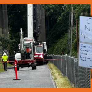
Ross says PP&R staff have been working to fix the path since March, but that it “has proven to be a unique fix that is far more complicated than a casual observer might realize.” The full repair is being broken into two parts. The first, planned for completion “this winter season”, would repair/replace the damaged section of the path and return it to its original width. The second step, to happen next year, is to reinforce the riverbank itself and ensure that it doesn’t wash out again in the future.
Ross points to “complex” permitting requirements as one reason for the delay.
Since the work to shore up the riverbank is “in-water”, it requires special permits from the Army Corps of Engineers. Those permits than trigger a consultation with the National Marine Fisheries Service and US Fish and Wildlife. Then there’s the greenway permit required by the City of Portland, a permit from the Bureau of Development Services, the Oregon Department of State Lands, and so on.
Ross says funding is coming together and they hope to start the project soon. Asked whether they would close the path completely if the erosion worsens, Ross said PP&R will continue to monitor the area and that he doesn’t want to rule anything out. “Safety is the top priority for Portland Parks & Recreation, and we will act accordingly as conditions dictate.”
Once repair work begins there will likely be a detour, with a complete path closure between the Oaks Bottom parking lot north to SE Ivon (near Ross Island Sand & Gravel).
Stay tuned. In the meantime, use caution and slow down for oncoming traffic when you see the orange cones.


Thanks for reading.
BikePortland has served this community with independent community journalism since 2005. We rely on subscriptions from readers like you to survive. Your financial support is vital in keeping this valuable resource alive and well.
Please subscribe today to strengthen and expand our work.
In a weird way, I kind of like the damaged trail. Having this one pinch point, approximately halfway between Oaks Bottom and the path entrance near Division, kind of promotes responsible shared usage of a limited resource.
Kind of stretch for a silver lining, I know!
It is on my commute route, and I have to say I’ve been really impressed with how careful people are around that tight spot.
I thought I was joking about the wintertime being “the snorkel months.”
Considering that the rail line gets used about once a month it would sure be easy to remove a section of the fence and build a hard packed gravel detour around the work area.
Of course there are very few rail operators who share their ROW and I expect Portland Traction to be as stingy as the rest.
This is absolutely not true. I used to live right next to the rail line (in Sellwood), they run trains on that line DAILY, multiple times a day.
How long ago? Recently they’ve been doing repairs underneath McLoughlin Blvd, that blocked the tracks, and didn’t seem to be in any particular hurry about it. In 6 months of commuting along the Springwater on the Willamette, I never once saw the Oregon Pacific tracks being used by anything other than maintenance equipement.
I work just off the Springwater in Sellwood, and there were trains several times a day in the summer, and it seems to have slowed to a few times a week or less now. [Just in daylight observation, that is.]
The other thing is, the trail itself sits on what used to be the OPRR right-of-way, that they somewhat generously ceded to Metro for public use as a trail. (I say somewhat because in exchange Metro paid for a significant rebuild/repair/upgrade of the line.)
“Parks yet to begin repairs of eroded Springwater Corridor path other than complex permitting and safety checks that occur during every transportation repair project that the public is involved with”
FTFY
Carry on.
“Those permits
thanthen trigger a consultation …”FTFY. 😉
It would be nice if we had money to actually build a real boardwalk type look out at that bend. If we have to shore up the hillside, we could do it right and have a nice viewpoint of Ross Island.
As daylight dwindles and commuters start to rely on bright headlights, that choke point has become even less comfortable. It’s bad enough when that 400-lumen monster is 10 feet away on the other side of the path, but it’s borderline painful when it’s only a foot or two to your left.
is anyone holding the original engineers and builders accountable? Was this just some complete oversight? We’re building a path right next to a somewhat unstable cliff leading to the river in a city that get over 36 inches of a rain a year. Seems like someone should have envisioned this scenario at some point of the design.
You act as if 36 inches is a great amount. It’s about average for U.S. cities. And most large U.S. cities have rivers/large bodies water next to them.
I say somewhat disingenuously, that everyone who rides the trail, should bring a softball sized rock to pitch into the slide. By the end of winter, we will have stabilized the slide with drain rock!