(Photos sent in by a reader)
A new bike path on the western end of the Sellwood Bridge was just completed yesterday. Multnomah County spokesman Mike Pullen says it will be in place for about a year and that it’s one of many temporary alignments we can expect as the bridge is rebuilt over the next three years.
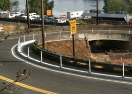
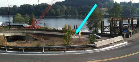
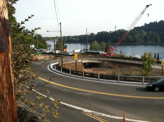
Heading west over the bridge sidewalk, you will now see a transition into a curb-protected path, separated from Highway 43 with plastic “candlestick” bollards. This path leads northbound bike traffic all the way down a corkscrew ramp. About two-thirds of the way down the ramp (once it is going south), you can choose to continue to Lake Oswego or Riverview Cemetery, or — if you want to go north toward Portland — you must make a sharp, hairpin turn (marked with an arrow in the image below).
Take a closer look at these two photos sent in by a reader:


Pullen says they often make adjustments and refinements based on how people are using new routes, so they’re listening for feedback and are open to making tweaks if necessary. Have you ridden this yet? You can comment here and/or contact Mike Pullen directly at mike.j.pullen@multco.us.


Thanks for reading.
BikePortland has served this community with independent community journalism since 2005. We rely on subscriptions from readers like you to survive. Your financial support is vital in keeping this valuable resource alive and well.
Please subscribe today to strengthen and expand our work.
Not just plastic bollards. There is a curb there as well. Westbound it is a nice improvement because it makes the path to the cemetery/LO easier, but it is narrow and also has to be shared, along with the bridge deck itself, with eastbound traffic. I like it but folks need to remember to take the downhill, corkscrew slow and watch for oncoming traffic.
Are you talking about oncoming traffic on the sidewalk? Because the lane is one way. I always just ride the road on the Sellwood, now this bike lane makes it a little tighter on that corkscrew, but I appreciate that this give more cyclists who don’t want to ride with cars better options.
I’m not sure it is one way. It is more of an extension of the sidewalk than a bike lane or cycle track
kudos to multco for putting a cycle tack in a location where one is needed. while i am 100% comfortable taking the lane on the sellwood bridge, this facility is likely safer than taking the lane. this is the way to do a *real* cycle track.
Was on this at 2 a.m. last night. It’s much better, still a pretty sharp turn in there, but so much more manageable.
I haven’t tried to cross the bridge yet…but I can say that in the process of constructing this, my own commute has become less comfortable. I ride down Riverwood Cemetary in the morning and used to use the dirt ‘path’ that went under the bridge to get over to the sidewalk south of Hwy 43. Riding in the ramp with Northbound cars is a prospect I dread.
Now it’s been torn up by the construction vehicles, and dirt and gravel piles are sort of spilling into it’s way. I wish I knew whether this area was going to continue to be open for use (which you can still go through it, but unless you ride a mountain or bmx bike you’ve probably got to walk) or whether they have some other plan to safely get northbound/southbound cyclists through.
This is definitely an area that needs tweaking. They constructed a new path where the hairpin is mentioned. This allows access to southbound travel when exiting the bridge sidewalk. However, the dirt path from the intersection of 43 with the Riverview entrance is now as described, making southbound travel from the intersection to the new path much more hazardous. This is the only non-road access for travelling south out of the cemetery to go south towards Portland, or to access the south sidewalk of the bridge. A paved path through the mess, like the one already constructed, would be a big improvement.
So I think this is fine for folks who are more comfortable in a protected lane, though are those folks actually taking the Sellwood Bridge at all? I usually go pretty fast down that part of the road and take the lane without problem, and the narrowness here is a concern for me… but I’m usually on my light road bike on a faster recreational ride when I’m there. It might be different on my commuter. I’ll probably still stick to the main road.
County Public works – please remember to sweep out this new segregated lane…since it will retain debris esp. after sanding in the winter. Or perhaps allow a group to adopt it? 🙂
Uh, folks, Portland is to the north.
As mentioned a couple times above, this new cycletrack is AWESOME if you’re connecting between the Sellwood bridge and Portland to the north.
However, connecting between this path and the Riverview intersection just to the south is a problem, especially since it looks like the area in between may start getting used for construction. Without this connection you are seriously SCREWED if you come out of the cemetery (or exit from the new Riverview MTB area just a bit further to the south).
I’m not comfortable taking the lane on the freeway-style ramps around the Sellwood Bridge (or on the bridge itself). Too much road rage on 43 — I used to live next to 43, and I think it is subject to some of the most appalling driver behavior in the metro area. The “Strong and fearless” can do that, but for the much larger of us in the “enthused and confident” category (which is almost ALL cyclists in my age range, most of us having started to notice the effects of cumulative risk), and we still need an off-street connection to and from the south.
I just wrote an email to Mike Pullen to inquire about plans to improve the access to the northbound westside path on the river from the Cemetary. As others have said this seems a great improvement for traveling off of the Sellwood Bridge but the connection from the Cemetary seems a bit precarious.
I love the idea of a curb-protected path with plastic sticks.
It makes me wonder why the City of Portland didn’t install this exact design to protect the bikelane on the Broadway Bridge, rather than the just the flimsy plastic sticks that motorists just keep on and on ploughing into, the no-good imbeciles!!
Please don’t be so hard on the plastic sticks, they have feelings too.
I take the Sellwood Bridge each way too and from work north of the bridge every weekday. I use the sidewalk, as I don’t feel like sprinting across the bridge in the road, (I have experienced numerous honks from motorists in the past when using the road at a slower speed). I normally enter the road at the west end of the bridge as I found the previous zig zag underpass annoying and generally poorly mainained (overgrown plants/garbage etc). The new set-up prevents sidewalk users from entering the road where they previously could, therefore I have to choose between using the somewhat more annoying new narrow corkscrew design or riding the entire bridge in the road (or possibly avoiding the bridge and riding down to Hawthorne instead). I find it hard to believe that pedestrians will use the new design at all (narrow, right next to speeding cars, shared with 2-way bike traffic).
I want to start riding this from Portland, but once I get into Lake O its kinda hairy on boonesferry. anyone share a route they take? I would be going all the way to Wilsonville from Portland.
Unfortunately Joe, the only really safe route I know about is to climb the hill on the bike path along Terwilliger (next to Tryon Creek park). Then descend through the cemetery if you want to take the Sellwood Bridge, or stay on Terwilliger if you’re headed in the direction of downtown.
For those who ride the bridge sidewalk and then take the River View Cemetery route, the new bike ramp is a real improvement going westbound. But what is a person supposed to do going eastbound? After crossing Macadam at the light from the cemetery, I’ve started riding against car traffic until I pick up the bike ramp, but it freaks the cars out (me, too). But aside from taking the dirt path and then walking your bike over the pile of gravel, what else is there to do?