Portland Parks and Recreation has posted maps of the proposed alignment (PDF) of the North Portland Greenway Trail along with an online comment form to gauge public feedback about the routes. The City has been working with an advisory committee since January to come up with the precise alignment for the future 10-mile path that will connect the north end of the Eastbank Esplanade (near the Steel Bridge) to Kelley Point Park.
Reviews on the proposed alignment are coming back mixed. While there’s excitement to see progress on this project, I’ve gotten several emails of concern about the path’s southern segments. Below I’ll take you through the alignment maps and then share the concerns I’ve heard. (Please note: The orange dotted line is for a different trail project.)
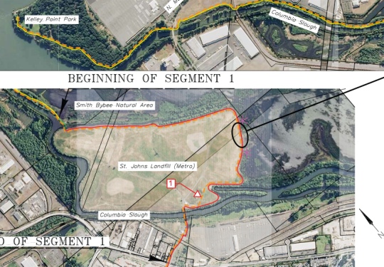
The proposed route begins by winding south through Kelley Point Park and Smith and Bybee Lakes on bike (and walk) only paths…
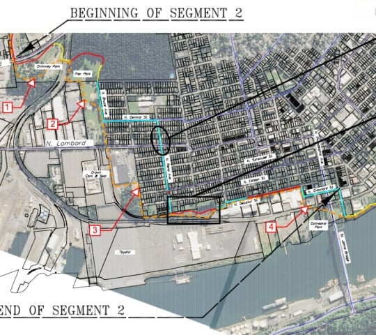
Then, the plan would be to use residential streets in St. Johns to get to the Willamette Riverfront near Cathedral Park under the St. Johns Bridge…
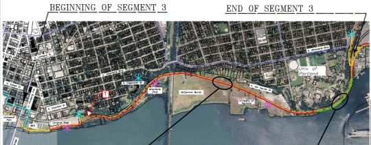
After that, the path would continue along the river, winding around the point at University of Portland’s campus with a “boardwalk”…
The pathway would then continue onto Swan Island with a separated path on N. Basin Ave. And this is where things go a bit sour. Instead of continuing directly south from Basin and connecting to the river via existing paths, city planners are proposing to take the route up onto surface streets via N. Going Street…
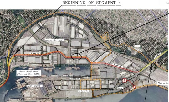
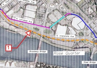
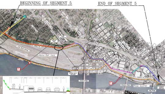
From N. Going, the route would take people onto a separated path on N. Greeley Ave, onto existing bike lanes on N. Interstate Ave, then left via a new two-way cycle-track on N. Larrabee, across Broadway and then through the Rose Garden to the existing bikeways in the Rose Quarter Transit Center…
Reader Max D. wrote in today about the alignment proposal and called the section from University of Portland to the Rose Quarter, “largely hacked-in along roads.” Max realizes putting the path right on the river isn’t always an easy proposition; but in his opinion, the plan, “lacks vision and backbone.” “I fear that that a weak, watered-down, convoluted trail alignment that is still just a concept gets the project off on the wrong foot!” he wrote.
“[The trail] needs to be along the Willamette River, especially where the trail is already in place!”
— Lenny Anderson
Lenny Anderson, who heads the Swan Island Business Association and whom by all accounts could be considered the Godfather of biking and walking on Swan Island given his role as founder and former director of the Swan Island Transportation Management Association, is also not pleased with the alignment proposal.
Anderson wants all further considerations and planning of the route past the point where Basin Ave intersects with N. Emerson/Ballast Streets (about mid-way through Segment 4) to stop immediately.
Instead of continuing south on Basin Ave, Anderson wants to see the route head west toward the river via Ballast Street (along a brand new “River to Lagoon Trail” being dedicated tomorrow (9/21)) and follow the already adopted North Reach River Plan Trail alignment. He says it’s just common sense to use the existing, one mile of the Greenway Trail that has already been built.
“The goal should be to get to the existing facilities… [the trail] needs to be along the Willamette River,” says Anderson, “especially where the trail is already in place!”
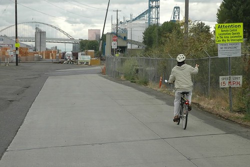
The existing path along the river ends a few tenths of a mile south of Going St. From there, Anderson would like to push to make the “Ash Grove Cement Road” the preferred alignment. That road is currently private right of way owned by Union Pacific Railroad that connects directly to N. River Street and Interstate/Larrabee at Tillamook. It’s often used by Swan Island bike commuters and others and trespassing is rarely enforced.
“Just drop any further work in section 5,” Anderson says, “until the city, state, and federals work something out to make the existing “Ash Grove Cement Road” a public facility, providing a vital second access to Swan Island and making the preferred trail alignment possible.”
——
We’ll be following this story as the plans evolve. For now, please take some time to view the alignment maps (PDF) and take the online survey to give your feedback to PP&R. The deadline for comments is September 26th.
You can also contact project managers Sarah Huggins at sarah.huggins@portlandoregon.gov or Emily Roth at emily.roth@portlandoregon.gov.
— To learn more about biking on Swan Island, join Lenny and lots of other fine folks down there tomorrow morning for free breakfast, trail dedications, and more. Get the details here.


Thanks for reading.
BikePortland has served this community with independent community journalism since 2005. We rely on subscriptions from readers like you to survive. Your financial support is vital in keeping this valuable resource alive and well.
Please subscribe today to strengthen and expand our work.
“…make the existing “Ash Grove Cement Road” a public facility…”
Yup. People coming from downtown and SE should not have to climb Greely to get to Swan Island.
‘Tis indeed for the athletically minded rider… ; ) The descent is totally worth it, though.
The northerly portions aren’t bad for a first draft; on the whole, it looks like a pleasant ride. I quite like the neighborhood access on N. Edgewater, which makes for a smooth transition to & from Willamette Blvd.
That said, I’d agree that the Swan Island segments are still a bit of a muck.
severely lacking balls.
Can’t wait for the St. Johns section. I’ll be able to watch it right through the window at work.
The separate path on Greeley would be incredible. Heading south you have to cross a lane of 45mph (air-quotes) traffic twice, it’s amazing there aren’t more serious incidents there.
this is supposed to motivate the “interested but concerned”? no. you’ve got to route around greeley to have a chance to encourage that group.
Those folks can just take the lane on Greeley!
Agreed – the cement road alignment is the way to go. Union Pacific was granted large amounts of land on the river and across the city for next to nothing. An easement would border but not impinge on the yards. UP previously worked with the city to allow the installation of the walkway on the lower deck of the Steel Bridge, here is another opportunity for UP to work with the city to provide a facility which addresses the needs of commuters yet minimally impacts the railroad.
This is not the kind of proposed trail alignment that will help bump our city up to Diamond status 🙂
Oh come on. I’ve been waiting for this to come in for, like, forever it seems. If there is no connectivity to the Rose Quarter, then beyond some recreational aspects, Willamette would still serve better.
I’m excited things are moving forward, but if we’re going to get more people using a bicycle to get them places we need really good off-road facilities. Let’s make this truly wonderful and connect it! Maybe this could be the new slogan for many routes around the city:
“Connect it!”
We have been to two of these open houses so far and I totally agree that section five is not ideal…in fact all it is, is just an upgraded urban facility from what we have now from the Esplanade to Greeley/Going. The upgrades would however be nice to have.
The first four sections can be looked at a continuation of “Going to the River” to the north connecting neighborhoods and parks. This will incredibly increase access to Swan Island from the north plus create a nice separated spine on Basin for commuters. I am happy enough with these sections that we are not planning on going to the final open house in late November. The Bluff boardwalk would be really nice.
The problem of course to the south is the rail road. When pushed at the open house: PBOT said the RR’s response was “You want to put a path where???” They seemed to have a less obnoxious reaction to the Sullivan’s Gulch trail…which they HATE, of course.
This chosen alignment is not the long term path for section five, it is an interim route that is “as good as we can do at the present time.” They wanted to end up with a report by the end of the year of something that they can REASONABLY built in the near term….not what would be nice. This on-steet route would do nothing to prevent furthering the route later and does not change the transportation master plan which calls for a riverfront MUP all the way to the Esplanade. However, I agree with Lenny who would know a lot more than I do about this “Cement road” that hooks up with River and Tillamook. It is not on the street maps, but I can sort of see it on aerial view. I doubt however that the railroad would ever relent on this since they require a certain distance away from the tracks for paths and there does not seem to be enough room between the tracks and the cement plant.
If there is any way that we can come up with some sort of public access agreement for this “road” it would make the on-grade connection to Swan Island from the south MUCH better overall and yet still be “temporary” until land use changes allow us to complete the riverfront boardwalk.
If we can not then the question changes: do we want to use the transportation dollars on upgrading the on-street access from the south or do we use it on another project somewhere else in the city until we can build the actual alignment…..hm…..
Looks like Google drove their camera bikes on the new trails on Swan Island. They look narrow.
Lenny has it right. Thanks for standing up on this issue. The Cement Road is a fabulous ride, the city should be able to offer the Union Pacific Railroad all sorts of deals in exchange for use of the road.
Otherwise, looks like fine progress toward creating a great commute and recreation route up the river.
All this stuff begins with years of planning, quiet work by advocates like Lenny, the whole NPGwy group, neighborhood associations, city staff, all working bit by bit to bring these things into existence. Keep up the good work, folks!
Ted Buehler
&, not to be a complete naysayer, I think its fabulous that they’re building a boardwalk around the PSU peninsula and all that, the rest of the system looks pretty okay, reasonably direct, the sort of fun naturey explorey experience you’d expect on a riverside linear park.
Ted Buehler
And, if Portland wants to achieve “Diamond” level recognition from the League of American Bicyclists, they had better think twice about locating the North Portland Greenway along a couple miles of urban expressways instead of along the Willamette River…
This is where the Diamond Level aspiration can be really useful, folks.
Ted Buehler
This makes no sense. Why would anyone who is not coming or going from Swan Island follow this route? Go through (not around) an active industrial area rather than continue along a rather pleasant section of Willamette blvd?
I like the first several sections, but from Swan Island south, I am reminded of the cliche “If you’re not going to do it right, why do it at all?” This does not appear to me to be an improvement over our existing system of bike lanes and greenways.
Well I tried to disprove you measuring it out on gmap-pedometer. But, it looks like you are correct. 4.14 miles via Willamette. 4.16 miles via the swan island path which includes the Waud Bluff trail, a steep hill up to Willamette Blvd. Things change a little if you stay down at the river level but basically it’s a wash. My understanding though is that the swan island path would be isolated from the roads…It would have to be as there’s no bike lanes, no sidewalks and 4 lanes of high speed trucks…clearly not a ‘greenway’
http://www.gmap-pedometer.com/?r=6529265
http://www.gmap-pedometer.com/?r=6529269
I’m curious about the swamp trail the runs along the slough and Smith & Bybee. This trail is so broken from the swamp-like earth. What’s the plan with this section of the trail? Seems like a maintenance nightmare. Of course, if something can be worked out, it’s a great part of the trail, the last connection to Kelley Point.
Correction: on the BP&R map the doted orange line is the Willlamette Greenway Trail alignment as shown on the Bureau of Planning/Sustainability’s North Reach River Plan adopted by city council.
The reason to have the WGT go thru Swan Island is 1. 10K folks work there, 2. its on the River and already has over a mile of WGT from N. Lagoon Avenue to the Ash Grove Cement Road, and 3. from there south the WGT has been built, its just not available for public use, and it (the “Ash Grove Cement Road”) is a beautiful ride.
A document that represents the will of the people of this city should ask for (demand? well Portland doesn’t do that!) an alignment that makes for a world class riverside greenway trail. It may take a long time to get it, but if you do not ask for it, you will never get it!
Maybe we can ask the city of Portland to look into building both routes, since the proposed route will take minimal infrastructure changes, if any. Then riders can choose the route they prefer, which will most likely be along the Ash Grove Cement Road. However, I do know riders who prefer hills and torture with the more hills the better. If only the proposed route is completed, then we should kindly ask the city officials involved and some Union Pacific officials to ride the new hilly Greeley route to see how THEY like it as compared to the nice flat stretches on either end of the ride, which would represent the alternate route along the Ash Grove Cement Road. Maybe then they will reconsider and let the Ash Grove Cement Road project get some more thought, some serious planning and approval to complete.
There will be a brown-bag lunch discussion about bicycle access to and on Swan Island this Wednesday the 26th at noon in the Willamette East room of the Daimler Corporate Conference Center. Representatives from the Swan Island TMA, PBOT, and Portland Parks & Rec will be there and it will be a good opportunity to learn more about the current plans, ask questions, offer comments and ideas, and show the city this is an important issue to us! The event is open to anyone but we especially encourage those who work on Swan Island and want more options for their commute to attend. Contact Lenny or Sarah at the Swan Island TMA for more details.
Wow, this trail would parallel my bike-commute for 10 miles ( I work near Kelly Pt Park and hop onto Interstate/Greely/Willamette/Rivergate from the Eastbank Esplanade). The trail looks like a nice ride, but I will most likely not use it, since it looks to add many minutes to the ride. This route is already a fantastic commute, since it is direct and fast with bike lanes on roadways the whole way except for a few broken sections in the Rivergate industrial area. So, I’ll leave this new trail to the joggers, homeless folks, dog-walkers, and skateboarders – I’m sure they will all make decent use out of it and I’ll continue to throw my lot in with the cars/trucks. I would much rather see the city improve those few small sections of roadway to the Rivergate area (Kelly Pt) that do not have decent or safe bike lanes (lombard and columbia past Pier and Chimney Parks), not to mention repair all the pavement utility cuts, sinkholes, huge cracks, tri-met track issues, storm drians, errant rockfalls, etc that break up an otherwise fantastic ride. City should focus more on the maintenance issues of the existing, premier bike lanes on roadways. It seems unclear how they will manage to maintain the new 10 miles of path.
I’m all for expanded access to the nature areas in Smith and Bybee and colubia slough areas (it is currently posted no bicycles on paths there by Metro). And getting any land back from the UP and putting to common use is always a great plan.
Thanks for your coverage of this Jonathan. We had a great meeting with various city entities (PBOT, PP&R, etc) today down here at Daimler Trucks North America (second highest team in the state on the Bike Commute Challenge in mileage, third in trips!). We voiced concerns on the new Going Street access, in-process Waud Bluff Trail, and the connections to and through Swan Island from the north and south.
We are pressing as usual for the ‘cement road’ at the river’s edge of the UPRR yard to be legal someday, as it would be the most natural of routes as regarding safety, scenery, and just utility (flat/quick).
One thing I heard at the meeting is that the separate path in Segment 3 under the bluffs of Univ of Portland is not really approved, they just put it in there.
Also informed them that Segment 4 is in serious error by omission of 1 mile of already built and beautiful riverside trail – from McCarthy Park S to the beginning of the cement road. Maybe easier to overlook that way? The one mile is shown in orange as if it’s just the ‘plan’, but it is already there and would be part of a standout ride experience along the river.