Like many of you, I’m still trying to figure out what exactly is going on with the Sellwood Bridge project. I have not followed it very closely since the celebratory groundbreaking back in December. My sense was that the project came out great for bicycling with ample riding room and connectivity.
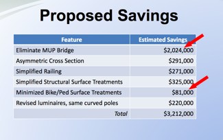
Then, on Tuesday night at a PBOT Bicycle Advisory Committee meeting, I heard the first murmur that changes were afoot. By Wednesday, the news was public that, due to a variety of factors (including under-estimated project costs and rising steel and fuel costs), the County needed to shave $3.2 million off the project’s cost. I’m still not clear on how the cost-cutting decisions were made; but the fact remains that of the $3.2 million in cuts, about $2.1 million directly impacts bicycling.
With the final vote for the project plans due this Thursday (7/19), the timeline to evaluate exactly how these proposed changes impact bicycling — and what might possibly be done to lessen that impact — is very tight. Today, an influential committee of local leaders (that includes Mayor Sam Adams, Multnomah County Chair Jeff Cogen, TriMet GM Neil McFarlane, ODOT Regional Director Jason Tell, and others) will make their recommendation on the project. Given this timeline, the Bicycle Transportation Alliance (BTA) is asking Multnomah County to delay the vote and I’ve read many emails and comments from Portlanders who are upset by how the proposed changes will impact bicycling
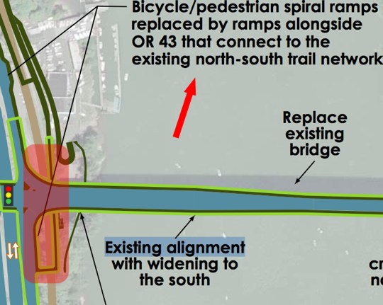
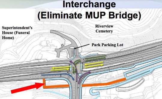
The design approved after a six year public process included a multi-use path on the west end and south side of the bridge to take people down to the Willamette Greenway Trail. In the newly proposed “asymmetric” design, that 700 foot multi-use path (MUP, a.k.a. shared-use path) bridge would be completely eliminated. The first graphic below shows the LPA design, and the second is taken from a presentation by Multnomah County made to the Citizens Advisory Committee one week ago:
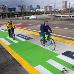
Another area where the County is proposing to save money ($81,000) is a line item named “Minimized Bike/Ped Surface Treatments”. Those treatments consisted of green colored bike lanes and a different pavement texture on the raised, shared bikeway/walkway in order to encourage people to maintain their lane. Here’s how the County described those treatments in an open house back in November:
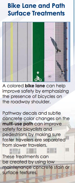
And here’s another view of how they looked in the old, symmetrical cross-section.
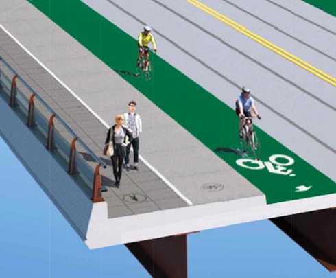
And as you can see below, these treatments are completely gone in the new cross-section:
(UPDATE: At the Project Stakeholders Committee meeting going on right now, project manager Ian Cannon said that the green-colored bike lanes are still in the plans. He said they proposed taking it out (for the $80,000 savings) but the Citizen’s Advisory Committee urged them to keep the coloring in.)
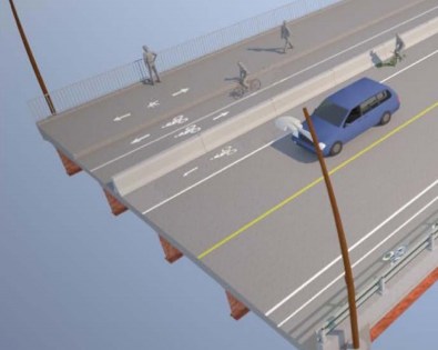
And of course the big change is the new cross-section. The newly proposed design shifts a bikeway and the sidewalk/walkway to the north side. With less access on the south side (elimination of the MUP bridge) the County figured they could save money by not having a sidwalk on both sides.
Here’s the originally agreed to, symmetrical cross-section…

And here’s the newly proposed, asymmetrical cross-section…

These are just the line item changes in the newly proposed design. There are also major concerns being shared among advocates of both bicycling and walking about connectivity for non-motorized users of the bridge in both directions. To learn more, follow (and join in) the discussion taking place on our post from Friday.
Keep in mind that there are some benefits to the new asymmetric cross section. The new design would add a separated, bi-directional bikeway on the north side. It would also do more to separate biking and walking. The concerns I’ve heard so far have more to do with how the bikeway connects (or doesn’t) to the bikeways on either end.
I’m anxious to hear what Mayor Sam Adams has to say about this new proposal. Stay tuned for more coverage from today’s committee meeting.


Thanks for reading.
BikePortland has served this community with independent community journalism since 2005. We rely on subscriptions from readers like you to survive. Your financial support is vital in keeping this valuable resource alive and well.
Please subscribe today to strengthen and expand our work.
If saving money were motivating these changes, bike accommodations seems like an odd (if also familiar) place to cut. Don’t the folks in charge appreciate that riding bikes as transport saves everyone money in at least a dozen measurable ways? Even as those $$ aren’t being budgeted for the bridge construction? Maybe we need to think of ways to calculate these costs not as one-time construction costs but lifecycle citywide savings….
since they’re cutting safety I suspect that the first person bicycling to get hit by a car will sue the city… they’ll lose money in that lawsuit that they could have spent increasing safety… and they’ll have to revisit safety improvements after construction is done and their options are limited…
ouch is right ” but the fact remains that of the $3.2 million in cuts, about $2.1 million directly impacts bicycling.” 🙁 why?
9watts – “citywide” savings won’t influence any decisions on this project, as it is a county project. The county doesn’t maintain anything in the City of Portland other than the actual bridges.
Personally, I don’t understand the elimination of the bicycle treatments. $81,000 is pocket change for something which noticeably and demonstrably impacts bicycle safety on the bridge.
Point taken, Matt. I should have said county-wide. But even just on the question of bridge maintenance I suspect one could make some calculations….
Get involved, call your county commissioner. Find out who & how here, in case you didn’t catch the previous post’s comments.
http://web.multco.us/document/38070/download
Jonathan, am I understanding this right, that there is a new overpass to be built on the west side that will allow for straight riding into the cemetery? No more cloverleafs and jogging? I was not aware that was part of the project, what a wonderful thing (if it actually gets built). I was just commenting last week, how the new Sellwood design seemed too good to be true.
I’m also really confused about why they have two lanes of traffic turning east onto the bridge when the bridge is only one lane wide?
I was confused about this “MUP bridge” in the first article about this as well… it looks like it’s a little bridge that connects the southern bridge bike path to the existing MUP trail so that bikes don’t have to travel in the auto lane or the intersections in order to get to the bridge bike lane…
removing that dedicated bike access is a huge safety issue…
Our continued addiction to facilitating fossil fuel-based travel is absurd in light of the carbon crisis that threatens all of humanity, and many other life forms, as we spew carbon molecules into the atmosphere as particles of mass destruction. Heating the earth’s surface is now already at emergency levels, and will only become far worse as we continue to burn fossil fuels to move weight. Policy should now be explicitly discouraging auto use in favor of human-powered (bicycling and handcycling) travel and walking. If we really grasped the dangers to life on the Planet, we would eagerly embark on a Manhattan-like project to dramatically phase out as quickly as possible our use of carbon to maintain our modern lives (travel, heating, cooling, communications, etc.). In other words, it is the preservation of our modern, insatiably consumptive lives, that is killing us. Isn’t this absurd, and insane?
Love how ginormus projects like this like to put out these completely vague and unhelpful diagrammatic maps which are confusing and clearly designed to obscure details. What the hell is that first picture? What is the orange line and blue lines in the second?
the first picture is the west end of the bridge… the highlighted orange part is the second picture… the orange line is the MUP bridge that’s getting cut from the budget… blue lines are existing MUP…
I’m not married to the new design now that I’ve seen more details of the old. Keeping faithful is hard to do as divorcing yourself for the new is quite enticing. Like an old spouse, domestic relations of years with the old bridge is just not getting along.
You could always have an affair with Hawthorne. I hear she’s easy and open.
Isn’t it ironic that rising fuel costs are one of the main reasons for the need for cost cutting?
Yes, but what I think is ironic is that the irony appears to be lost on the decision makers.
Although I don’t care for the phrase itself, Alan Durning’s car-head comes to mind.
Even more hilarious that rising fuel costs mean cutting bike and pedestrian features. You know…those forms of transportation that save fuel!!
Why are we so backward?
Especially as fuel costs have dropped significantly. What exactly did they foresee fuel costing when they budgeted this? $2 a gallon?
I am confused as to why there are three bike lanes next to each other, and why one of them is exposed to traffic, while the other two and the pedestrian lane is behind the barrier. Why not protect all pedestrian (bikers and walkers) behind the protective barrier? And agin, why 3 bike lanes, aren’t only two necessary?
I agree Paul, that is a strange set up. And why have the MUP portion divided into two sections? If there is a green bike lane on the road surface, I can see the walkers getting up in arms about bikers on the MUP portion.
I completely agree.
I really like the fact that two of the lanes are inside a protective barrier but I don’t understand why there is a third one that isn’t. I’m not really quite sure what purpose it serves.
The purpose of the bike lanes adjacent to the car lanes are for cars to be able to break down and take the bike line. Think of it as a shoulder and it makes sense.
how much does that jersey barrier cost? that is a safety hazard all by itself.
They could easily make up the 3.2 million by adding back the one feature that they took off the table years ago….toll booths.
+1
Why are rising fuel prices cited? Fuel prices have declined nearly 25% since the bridge design was announced.
Perhaps the MUP was never really on the table… Maybe added to the original plan in order to get the project started, all the time knowing it could be easily scrapped due to “rising fuel costs” or whatever other BS reason.
It’s pretty clear that the bike lanes on the road surface only exist as breakdown space or future auto lane expansion (perhaps a peak direction or transit-only lane). Honestly, the cycle track and sidewalk are enough to handle the pedestrian/bike traffic on this bridge. They could save a lot more money if they eliminated the suicide bike lanes in the latest proposal and kept all cyclists on the cycle track. Their motives are obvious.
I’m still really confused. What are the remaining bike facilities after this cut??
Looks like the danger is passed. The twitters are saying the new design is off the table, and the original symmetrical design is back.
yes and no…while the PSC voted to support the long-studied “balanced” alternative, the County Commission could choose to support the “asymmetrical” option. Not likely, but still possible.
The bike lane up against that jersey barrier is a death trap. I hope peejay is correct that the changes are off the table.