viable alternate route.
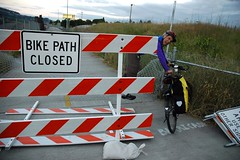
(Photo © J. Maus)
This morning’s news that the Morrison Bridge multi-use path will be closed to both directions of bicycle traffic from this Monday until mid-September, was just the latest in a string of closures that impact vital connections in our bikeway network.
This post will hopefully serve as a reference for the current closures and as a place to share your experiences with the detours.
Thanks to reader Esther Harlow, below is a handy map to give you a perspective on how close and interconnected the closures are. Below the map, is more information on the four closures:
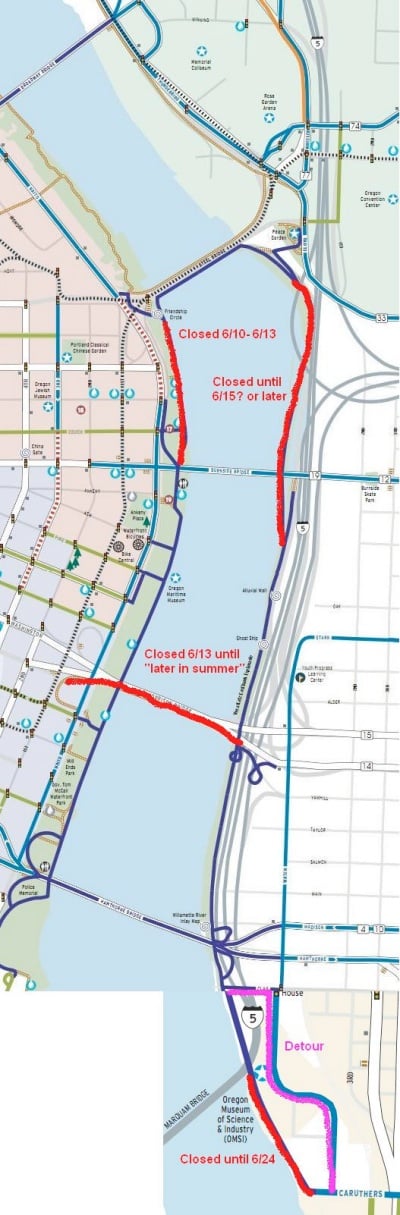
Here’s a list of the closures:
- Morrison Bridge multi-use path (closed from 6/13 to mid-September): The path will be closed for a construction project that will replace the lift span. The closure starts Monday June 13th and is expected to last until mid-September.
- Eastbank Esplanade – Floating Section (estimated opening June 15th): The floating section of the Esplanade between the Burnside to the Steele Bridge has been closed by the Portland Parks & Recreation Bureau due to high water on the Willamette.
- Waterfront Park south of Steele Bridge (closed until Monday, 6/13): The U.S. Navy, who has ships in dock for the Rose Festival, has closed a section of this path due to security concerns (which they’ve done every year since 2002). Please note that the Steele Bridge lower deck is still open and you should be routed onto SW Naito. Also note that when the ships sail out on Monday, expect 15-25 delays for bridge lifts.
- Esplanade near OMSI (closed through 6/24): TriMet has extended this closure so crews can begin preliminary construction of the Portland Milwaukie Light Rail Bridge. The Esplanade is closed between SE Clay and Caruthers. The detour takes you onto SE Water Avenue. (See map here)
Many readers have expressed frustration about these closures. Having to find alternate routes when there aren’t redundant safe access options for bike traffic like there is for cars is one thing; but we’ve also heard that the lack of signage around these detours is making things even more difficult.
One of the problems at play is that several different agencies have management authority over these bikeways. Portland Parks & Recreation manages the Esplanade and Waterfront Park (with some coordination with PBOT), Multnomah County controls the Morrison Bridge, and TriMet manages the light rail project.
When you mix multiple bureaucracies together with a culture that doesn’t always fully respect bicycle traffic (to the extent it respects auto traffic), you get a situation where mitigation for bike traffic impacts isn’t taken as seriously as it should be.
Detours and closures that impact bikeways aren’t new and they’ll continue to become an issue as bicycle use increases. Perhaps it’s time for a citywide ordinance that calls for minimum, bike-specific requirements for detour signage and closure mitigation practices?
What do you think? Please chime in and let us know what you’re seeing out there and how these detours are impacting your ability to get around.


Thanks for reading.
BikePortland has served this community with independent community journalism since 2005. We rely on subscriptions from readers like you to survive. Your financial support is vital in keeping this valuable resource alive and well.
Please subscribe today to strengthen and expand our work.
Long overdue. I’ve noticed the city has generally gotten better at marking out bikeways around projects, like with whatever they’re doing at Burnside and Broadway, or most of the time on the broadway bridge. We really ought to have our own space on Naito and MLK/Grand .
Looks like there’s a key missing– the colors aren’t explained, though they can probably be figured out. Otherwise, awesome. Thanks for publishing something so quickly–was getting really frustrated about how to commute. Maybe also do a quick guide on how to do a round trip touching all four quadrants for those who aren’t so good with planning (Hawthorne Bridge, Springwater, Burnside, Naito–I think)
red means go.
Natalie – these are copy/pastes of the awesome neighborhood maps published by PBOT, available here: http://www.portlandonline.com/transportation/index.cfm?c=39402&
The main part is from the NW/downtown map and the small part at the bottom is from the SE map. I recommend getting copies of those maps from PBOT to have handy year round.
Normally I don’t get bitchy about these things, but we’re talking about the key arteries here. At least for me. Would they close I-5 so casually? No. Gotta take a big detour to get home tonight. At least it ain’t raining!
actually… In LA this summer they are closing I-405 for an entire weekend. If you’ve never been to LA that doesn’t sound like much; however, by comparison what we’ll be facing is almost laughable.
But they’re closing it on a weekend. When the number of people trying to commute to work is vastly lower. (They are presumably working three shifts around the clock to make it happen in a weekend, which is far more expensive than if they had done the work during normal construction work hours, on weekdays.)
A big part of the problem with the path closures here is that they sure feel like they are done casually, without recognition of the important transportation role they play. The Morrison Bridge closure, in particular, illustrates this — they announced the closure three days before it is to happen! Are there signs up now on the path, at least warning people as they commute home that it will be closed on Monday morning, when they ride back in to work??
But I wonder if the county really thinks of it as transportation infrastructure — it’s a “multi-use path”, where people go for a stroll on a sunny day, or jog, or go for a family ride on the weekend. (All of those are important things, and inconvenienced by the closure, but they don’t suffer the same impact as someone who depends on the path for their daily commute and who will show up at SE Water and Yamhill at 7.30 Monday morning to discover it’s closed.
If you ride south on the westside there are a bunch of closures.
The Willamette Greenway trail (west side) is underwater at the Riverpoint Condos, from about Pendleton to the Sailing Club. The Riverpoint condos have closed off access to their parking lot (aka “Riverpoint Lane”) so the 100% legal bypass is Macadam ave.
Complications: Construction on Moody has kicked up a notch, so the sidewalk (which bikes & peds must share during construction) is even more constricted & messy.
I-5 construction on the Iowa St. viaducts is moving up to Barbur which narrows to 2-3 lanes (and no bike lane) at some times.
AND! Seismic testing west end of Sellwood and the cemetery. Not a big barrier to bikes (yet) but still an occasional hassle.
The only reliable clear passage to outer SW from downtown is Terwilliger.
RE: Waterfront Park south of Steele Bridge. I just rode South on Natio from Steel Bridge down to Taylor and back. It is fairly dicey since the eastern-most SB lane that is now the bike travel lane is also being used as a loading/unloading for trucks and has people milling about. It was a tight squeeze in several places. Slow down and keep your head up.
An earlier post about the impacts of the high water levels showed the path at McCormick Pier Condos under water. But the condos have had that path blocked off at the Steel Bridge end for months now.
What’s the story on that? Are they closing it to keep the public out? And if so, does the public have a legal right of access? (Does the city have an easement for the ‘greenway’ trail?)
yes, the lack of signage is most frustrating. as a cyclist still learning the bike friendly streets in portland, a closed path leaves me wandering aimlessly.. even a little print out from google maps with highlighted suggested alt-routes would do a world of good if posted next to the sign. if I traveled any of these closed routes with regularity I’d consider making such signs myself.
anywho, thank you for this post, it allows me to at least plan for this now.
This is a great idea, Janet! We could start a forum here to brainstorm logistics on how to get our own signs up…collective bike-citizen action!
As I was getting ready to ride to work this morning, I heard two similar traffic reports on OPB, 1-5, slow from Marine Drive to the Fremont, I-84 blah, blah, blah. Drivers have it easy, traffic is the same every day and if there are major closures, there are postings, news clips etc. This last week or so, I have been chatting with other riders in an attempt to find out what was open, closed or different from the day before. Sure this brings a community aspect to my commute, but how about some of the news stations do a bike traffic report? Sounds pretty basic to me.
Are there any bicyclists who work for OPB? Can we channel through them suggestions for bicycle coverage in their traffic reports?
Since we have our own network of people; most likely people who work for the media, the county, and so forth; lets take advantage of our network of bicycle friends who work in these places as well as complaining here.
I think the city should have good plans in place for closures that reroute transportation. I expect this for autos and bikes. If more bikes get routed into traffic the city should make sure appropriate safety measure are taken. I would like the city to consider slowing down cars, temporary bike lanes, etc…basically what ever is reasonable to make sure traffic flows safely. Maybe they have already done the appropriate assessments, if so…good job.
The closure of the Eastbank Esplanade bites. I head up to North Portland with an Xtra-Cycle full of tools, and I am still unsure what the best route is to get around without riding on the sidewalk on MLK.
Well, yer route should be the same as before the Esplanade closure as far as north of the Steel Bridge, right? Maybe through the Rose Garden TC and up the Williams-Vancouver couplet northbound, hang a left at some point to NoPo, like on Rosa Parks or whatever…
MLK would be a no-go without a specific destination thereon, heavily-laden longtail-wise!
D’oh! Chris, you probably mean before that!
How about picking up SE 7th NB and wending over to 12th to cross I-84 below Lloyd Ctr, hang a left after that overpass and head west back over to 7th then North to Tillamook & cross MLK west to Williams or even keep going to Interstate if need be by following Russel west instead.
This is pretty much the route I take when not going further east.. from OMSI, Water to Stark, Stark to 6-9th any do, 12th st overpass, left to 7th or 9th (9th is a little nicer even though 7th has a bike path) and then cut over to Williams somewhere after Broadway.
And if one don’t care to ride Stark, Water to Clay Clay to 7th.. etc.
Unfortunately the best route is to go up Multnomah instead of getting on the Esplanade. Take that street up to 12th and turn right, careful for the teenagers. Keep going on 12th, it will transition to Sandy and then to 7th. There really aren’t any other through routes of 84 lower than this that are in any way bike friendly. MLK is a nightmare on a bike.
It sucks, the lower east side has really nothing for bicycles. The esplanade is usable when it’s rainy and cold, but once the weather turns it become a recreation area and not a transportation corridor so you need to ride no more than a titch above walking pace. We need a north- south bicycle highway like I-5 in a bad way.
It turns out riding Naito is sketchy because they didn’t maintain a pedestrian right of way on that side of the rose festival.. so people are walking in the bike lanes, bikes in the travel lanes.
It’s a complete mess, and I think we need to do better than this.
People sure do like to complain about having to ride 1/4 mile out of their way. I thought you guys LIKED riding your bikes. Chalk another thing up to “first world problems.”
A good many people like driving their automobiles, but will still complain about having to take detours when they’re driving to and from work, because that’s time taken away from being able to do /something else/ with that time. If this is a surprise to you, consider yourself fortunate that you’ve never been in that situation.
But how many of those drivers go home, hop online and complain ad infinitum about every detour, pothole, rude driver, and inconvenient stop sign? Commenters here even complain about GOOD stuff that happens because it’s JUST NOT GOOD ENOUGH. So many complainers, maybe some of them should move to a city with better bike services. Oh, right, there isn’t one (in the USA, at least).
Nice attempt to patronize, but it’s usually much farther than that, and more important, without proper signage people with little experience exploring the City on bikes wander around on streets they feel unsafe on. Not everyone has been riding for years in traffic and can go anywhere. Especially with the proliferation of extremely dangerous street car tracks all over the Central City.
I suppose another first-world problem would be your sad whining about other people’s concerns.
These closures are inconvenient and annoying, and the apparently off-handed attitudes of the various agencies responsible is certainly irritating but let’s keep things in perspective – I’d still rather bike in than drive in (especially now that it’s finally dry).
I got caught in Thursday’s jam on the lower steel bridge. Riding in to work that morning on the same route there was no indication via signs or notices that the bridge would be periodically closed that day. I work in SW and knowing this in advance, I would have taken Hawthorne Bridge home that evening. Instead I weaved through the heavy crowds on the esplenade, waited at the closed Steel bridge for some time, searched for the Broadway bridge (never taken it and couldn’t find it), returned to the Steel Bridge which was down for a train crossing yet still closed to bikers and walkers, then weaved back through the crowds to quite quickly cross over the Hawthorne. Despite all this, my frustration was that, despite the pomp and circumstance with the fleet and the resulting lower bridge closure, a measure of courtesy would have been for the person staffed on the bridge to have been stationed by the shore where they could inform bikers and walkers how long the wait would be until the bridge opened again.
It would be better if the various agencies collaborated more effectively on creating viable alternatives, and put up wayfinding signs that indicated those alternate routes. I don’t know if an ordinance is necessary, but some administrative rules would be helpful and advisable.
Weird experience on the Burnside Bridge Thursday afternoon, biking westbound into downtown. A police officer stopped me, not quite halfway over, and everyone else biking or walking over the bridge and told us we had to cross to the other side. The water spouts were going, but it seemed perfectly safe to cross the bridge. For whatever reason, it was deemed unsafe to walk/bike along the north edge of the bridge. What was annoying was that I didn’t have the option, per the officer’s instructions, to ride in the auto lanes, even though cars were allowed to continue westbound.
To make the situation more annoying, he didn’t bother stopping traffic, so I had to wait a while before there was a break large enough to make it across the bridge’s travel lanes. It seemed to me the way the whole thing was handled created a more dangerous situation than whatever situation they were trying to avoid.
Gee, the Springwater closure (on my daily commute) has been “extended” from the original 3 weeks we were promised? Color me shocked that a construction project is taking longer than expected!
What I don’t get is how it’s being extended “so crews can begin preliminary construction of the Portland Milwaukie Light Rail Bridge.” I thought that was the reason for the closure in the first place.
Oh, one thing we can be grateful for … at least the summerlong closure of the Springwater from OMSI to Sellwood for Oaks Bottom’s environmental makeover, was delayed from this year to next year. Amazing as it sounds, things could be worse.
Don’t be that guy. Don’t run he road blocks.
Also, I have to wonder why proper detour signage and closure markings are so hard to figure out…they’re the same as they are for cars, there’s not a “screw the nonmotorists” clause in the MUTCD, nor is there an exception that you don’t have to follow it if you’re not a department of transportation (I’m looking at you Parks & Rec)
Got OpenCycleMap updated.
I understand the need for closure; the thing that annoys me is the lack of warning signage. Several days ago in the very early morning, I happily ran from the Convention Center, along the east side of the river, to Sellwood via the Springwater Corridor trail. On my way back, however, I found the floating part of the Esplanade had been barricaded closed, which forced me to cross the river at Burnside and (ugh) hurdle dozens of sleeping-bag entombed vagrants who were finding shelter at the Skidmore Fountain Max stop. Fortunately, the Steel Bridge was still accessible (at that time, at least) enabling my return home.
This is the third time in 4 months I’ve started a run, only to find the path closed on my return trip, leaving me no safe alternative to return home. Come on, Portland! Let’s get our act together! (But thank you for providing this blog to vent and find validation!)
Better signage would be good, yup!