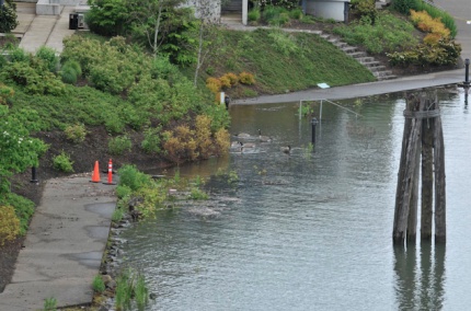
(Photos © J. Maus unless noted otherwise)
The Willamette River through downtown Portland is just about one foot from what the National Weather Service considers “flood stage.” While actual flooding isn’t in the forecast (at least not at this point), the high water has already done damage to many people’s daily bicycle travel.
We brought you photos of the high water last week, and then news earlier today that the floating portion of the Eastbank Esplanade yesterday had been closed.
In addition to that closure, several portions of the Willamette Greenway Trail on the west side of the river are fully submerged in water.
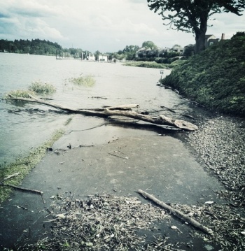
Readers have reported that at least two sections of the Willamette Greenway Trail between the Ross Island and Sellwood Bridges are flooded. One reader says a large section of the trail near SW Pendleton Street is flooded, although, “Luckily the puddle isn’t too deep to ride through.” Another reader tells us there are two other sections that are “completely impassable” in that same general area.
Here’s a photo of the Greenway Trail near Pendleton/SW Riverpoint Lane sent in by Paul Souders…
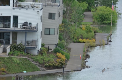
Also on the west side, a portion of the Willamette Greenway Trail in front of the McCormick Pier Condominiums (just north of Steel Bridge) is under water and the river is mere inches away from claiming other portions…
At about 4:00 yesterday afternoon, City of Portland Parks & Recreation crews officially closed and fenced off the floating portion of the Eastbank Esplanade. I was there just minutes before the gates went up and watched many people try to negotiate the steep, nearly 90-degree curb up to the floating ramps…

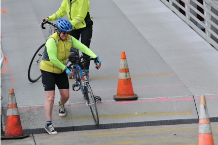
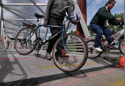
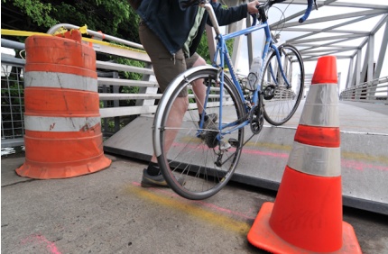

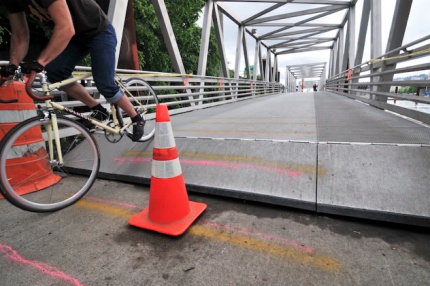
The big hurdle up onto the ramps was hard enough (as the photos can attest), but it was really crazy when there were waves in the river (caused by passing boats). I watched the ramps move up and down with the waves, leaving a 4-6 inch gap between the bottom of the ramp and the paved portion of the trail. It was pretty unnerving to say the least.
Watch the video below for more (it shows the gap/wave motion as well as some footage of how various people negotiated the curb, including a woman riding a tadpole trike who manages to hop up onto the ramps):
And finally tonight, just for some fun, here are a few more shots of the historic high waters on the Willamette.
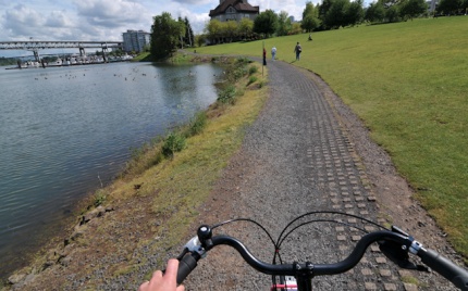
Check out how close the water is to the path in Tom McCall park…
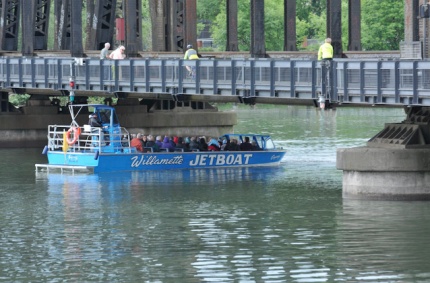
I spotted this jetboat which came just inches from hitting the Steel Bridge…
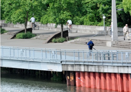
The photo below was taken from the Hawthorne Bridge looking north to the Esplanade…
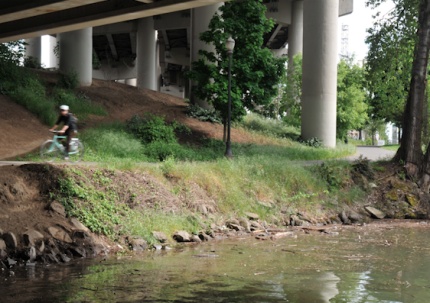
And this one was taken under the Hawthorne Bridge looking southeast at the Esplanade toward OMSI…
If the river continues to rise, we’ll keep you posted on how the Esplanade and other paths are impacted.
Portland Parks & Recreation says the Espanade closure will last at least week “or longer” depending on conditions. Sources say the closure will remain until the water level drops, which could be another 3-4 weeks.
Let us know about Willamette River conditions as you ride around tomorrow. Drop us a line via email, call our 24HR TipLine at (503) 706-8804 or connect with us via Twitter. We’ll try and keep a running list of closures.
— For an accurate and updated look at Willamette River levels, check out this page on the National Weather Service site.




Thanks for reading.
BikePortland has served this community with independent community journalism since 2005. We rely on subscriptions from readers like you to survive. Your financial support is vital in keeping this valuable resource alive and well.
Please subscribe today to strengthen and expand our work.
I like the dude on the Trek jumping it. It makes me happy that some people still know how to ride a bicycle.
+1
word- let us wheelie!
Yeah that guy’s badass. He wins this post.
Awesome, my legs made it into this post. I came very close to falling off my bike (last photo /w cream colnago), thinking I don’t have to unclip as long as I go slow. Not so wise, as the platform started moving up and down, left and right. I really don’t understand why these extremely short ramps were used. If they were longer, the incline would be much more forgiving and wouldn’t impact the ramp’s ability to float/move. It would also serve as a better warning sign, since it would be visible from further away, giving approaching cyclists more time to prepare for the drop. But I’m sure there’s a reason for these cruel, deadly ramps.
Good to see they put cones up, the lame spray paint markings didn’t do much. I got some big air Sunday and a “nice” (could have also been for the Cinelli I was riding) in the section commenter @emre was pictured. But it would appear (from the 10:00 news) that the city closed the sections now. The transition ramps are/where too steep for the average joe.
This is not “historic”, and I’m surprised the ramps were not planned for at least the current level of flow. This is only a five or ten-year event. 1996 was almost 29 feet – 11 FEET over the current level. And the record is 4 feet above that, although the river bed and dams have changed since 1984, so it doesn’t really mean much anymore.
We got lucky this year, given the snowpack. A three or four day stretch of hot weather in Western Oregon a few weeks ago would have released the flood gates, so to speak, on the Willamette. And a stretch of hot weather in the Inland Northwest and Southwest Canada would have made the Columbia a bit more lively.
That is the nice thing about the never ending coolness this spring (still going about 5f below normal). If the switch flipped and we got hot weather, the late additions to the snow pack would be melting off very fast.
PPR really needs to post detour information. Right now they just have signs that the floating portion is closed. I saw a lot of people scratching their heads at the top of the causeway and asking questions about where to go. If you aren’t headed to downtown, most people don’t know good workarounds – oh wait, that’s because there are none. Anyway, for the record, if you’re headed to the inner east side, I suggest staying on the west-side sidewalk of MLK to cross i-84, then at Davis either cutting west one block to 3rd, or using the new lights over MLK/Grand at Davis to get over to 6th Ave (which also now has lights over Couch & Burnside).
Update: The Willamette Greenway Trail near Pendleton Street *is* now too deep to ride through. As soon as I saw it this morning, I turned back and took an alternate route up to Macadam.
It was at least 1′ over the trail last night and deeper this morning. There are at least 2 places on the trail underwater now.
You can avoid the water and Macadam by detouring through driveways & parking lots from Boundary to the Willamette Sailing club, but they are all marked “private.”
Watch out guys as sewage has just overflowed into the Willamette. With the extra water, though, it’s probably all dilluted, but still.
And remember: fleet week starts on June 8th, so they will be blocking off a good portion of the west side path for that. Riding north/south along the river is going to be a nightmare.
Every weekday I ride macadam north and south between West Linn and downtown. Maybe you’ve seen me. Maybe you hate me!? I am buff with buff legs and orange bag.
Cars are patient enough because I do mph on the speedometer.
Motorists seem patient while I tempo ride. They see me sweat. Maybe they hate me.
6:15a you can see me? We can deal with it over granola bars.
Every morning I fear I will die this way. I do it this way because it’s economical and I can get in the hot tub before work.