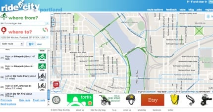
Ride the City, an online bike route planner that first launched in New York City in 2008, announced this morning that their tool now works for Portland. Developers Vaidila Kungys and Jordan Anderson say their map is all about encouraging folks to ride. “Our goal is to provide bicyclists with one more option to help them to get out to ride their bikes, and to find safe routes.”
Ride the City now covers the Portland region including Beaverton, Tigard, Tualatin, Lake Oswego, Gresham, Milwaukie, and Vancouver, WA.
Ride the City uses the wiki-powered Open Street Maps as its base map and it has several other very nifty features that make it an appealing option to Google’s new “Bike There” feature.
Speaking of Google, here’s what Kungys says when folks ask them why they’re still pushing ahead with Ride the City when the Google juggernaut also offers bike directions:
“I think it’s a bit of a strange question, it’s like asking Coffee People why they bother since Starbucks is everywhere or why anyone should choose Powell’s when you can get the same books from Amazon: it’s about providing more options to give users a choice. Ride the City offers a similar product–bike routing–with a different style that is more targeted to specific cities.”

Ride the City offers users the ability to select a “direct,” “safe,” or “safer,” route option. Their map also lists bike shops and bike rental locations and various data layers can be turned on or off depending on what you want to see. The turn-by-turn directions come with helpful icons that describe each trip segment as either being shared, on a bike path or on a bike lane, and there’s even a traffic cone icon that warns, “caution” (which I saw when my test route took me on Martin Luther King Jr. Blvd.). Making Ride the City an even more valuable tool is the ability to create a user account. This allows you to save preferences — such as telling it to always avoid a certain road — or to save specific routes.
Portland joins New York City, San Francisco, San Diego, Chicago, and seven other cities on the list of locations now served by Ride the City. The developers welcome feedback on routes and there’s even a “rate the route” feature where you can offer specific input.
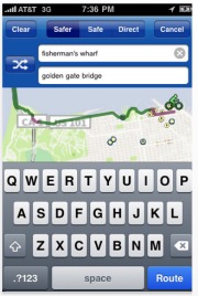
Ride the City is also available as an app for iPhone. It’s available in the iTunes App Store for $2.99 and offers turn-by-turn directions of all 12 cities, lists nearby bike shops, and more.
This is an excellent tool with a great look-and-feel that is much more bike-specific than Google. I highly recommend spending a few minutes poking around to see what it can do. Check out their FAQ page for more information and try out a route at RideTheCity.com/Portland.
— For background on online bike route planning, see this in-depth article by Elly Blue we published back in July 2009.


Thanks for reading.
BikePortland has served this community with independent community journalism since 2005. We rely on subscriptions from readers like you to survive. Your financial support is vital in keeping this valuable resource alive and well.
Please subscribe today to strengthen and expand our work.
Does this mean I can shut down byCycle.org?
Why isn’t there one for the whole of the US? (Google Bike There notwithstanding).
In the UK there’s Cyclestreets.net and that routing engine works UK-wide – it has similar functionality to Ride the City, including similar icons.
I’d love to find a whole US routing engine so I could use it on the Bike Hub ‘cycling satnav’ app. At the moment this only works in the UK. It uses bike routes, and less busy roads, thanks to OpenCycleMap and Cyclestreets routing.
The next iteration of the app will feature Phil Liggett giving the right/left/straight ahead/ suitcase of courage directions.
Big Thanks to Wyatt for all the hard work on ByCycle.org. I used it and loved it!
Carlton – Ride the City would love to do a U.S.-wide version using OpenStreetMap data. The data over here is just not as reliable as it is in the U.K. and elsewhere in the world. (In fact, I just got an email from someone in Beaverton whose 6-year-old subdivision isn’t yet in OSM and so he can’t see the streets on our map.)
As the OSM community grows in the U.S. — and more public agencies warm up to the idea of releasing data under licenses that are acceptable to the OSM community — the data will reach a point where it’s possible to do a nationwide biking application.
Wyatt – byCyle.org was a big inspiration when we sat down to do this in NYC in 2007. It’s also one of the reasons we felt we didn’t need to launch in Portland immediately.
Cross mobile platforms or FAIL
Thanks for the info, Jordan.
We have some terra incognito in some parts of the UK, too. Rural and run-down does not make for fertile OSM territory.
London and Cambridge are wonderfully mapped, but that’s because it’s wall to wall geeks, many of them into maps and bikes.
On BikeHub.co.uk and on iTunes I go out of my way to ask for newbies to help with OSM mapping. I do the odd bit here and there, especially for unknown cut throughs. It’s a karma thing: next day I could find a similar cut through by using the app.
It’s so cool to find out that keenies are using the app to save 2.3 minutes off a 20 minute commute. Routing engines – if given great mapping – are smart.
Tried to map my daily commute and it would not recognize the intersection no matter how I entred it. A very frustrating 5 minutes.
Nope, it doesn’t work. I typed in my address to the name of the company where I work and it randomly selected someplace ten miles in the opposite direction. Nice job, guys.
Wont handle exiting the Hawthorne Bridge for me (using direct). It directs you to take the ramp on the south side of the bridge to Naito and Jefferson (to continue to PSU).
Unfortunately, that would be the ramp on the wrong side of bridge to ride on in that direction.
But google wont let you go up SW Madison either, redirecting you down to the Waterfront Park paths.
That would be SW Main… going the right direction, with traffic.
Hey George & Jim,
Please make sure you leave a comment on Ride the City with the problematic addresses/intersections so we can see why they aren’t working. We’re using Google’s Geocoder API so it should work fairly well, but I may have to tweak the calls a bit to localize.
Thanks.
Is there an app for Droid phones?
Thirding the cross-platform request. Android, please!
I’ve requested my work commute, and I’m puzzled by the fact that even the “Safe” version doesn’t preference side streets or MUPs–notably the Waterfront Park or Eastbank Esplanade route that makes up a third or so of my daily ride.
I do like the selection of Direct, Safer and Safe, however, and the inclusion of bike shops and rental locations. Very handy.
To all Android fans: An android app is on the way.
Thanks,
Jordan
I find some features of this map very pleasing and it presents far less clutter than Google maps.
However, if I ask it to go from my house in SW Portland to NE Portland, it takes me directly over Council Crest and down Vista Ave. This is an extra 500 feet of climbing and some tricky downhill riding to save about a mile over my preferred route on SW Terwilliger. The route was the same using all three settings (safer, safe, and direct).
In addition, there didn’t seem to be any way to “grab” the proposed route to change it, and I didn’t notice how to add waypoints to force the mapping engine to choose another route.
Maybe this was due to my being an unfamiliar user, but until I find out otherwise I will consider this a work in progress and stick to Google for now.
“I think it’s a bit of a strange question, it’s like asking Coffee People why they bother since Starbucks is everywhere…”
The last I heard, Starbucks had bought and buried Coffee People. Maybe their business plan is to get bought and buried by Google.
Yes – thanks for all the hard work keeping Bycycle up. 😉
I have been using Ride The City in other cities and have found it more convenient for traveling due to its being iPod Touch friendly app vs. Google.
I am going to open up the Ride the City app right now and check out the Portland function – I just hope it will allow route to cross the bi-state bridges…this would be an important function.
It WORKS for Vancouver!!!! I was able to plot a route from Bad Monkey Bikes across the I-5 Bridge to CBD Portland!
Thanks for adding north of the river bike resources…since there is so few it is nice to know where they are for our visiting Portland bike riders.
I am glad you are able to get this working in the Portland area. I zoomed out to see the area you offer routing (I couldn’t route from my home) and I noticed your boundary to the South is quite unconventional. It’s not quite at the county line, but you are missing a lot of Clackamas County that is very accessible and ridable. Do you have concrete plans for updating/expanding coverage?
Nice, finally OpenStreetMap (no “S”) gets some attention. I wonder how long until they start pulling data for the rest of the US, since I’ve recently done a lot of work on the Tulsa INCOG local cycleway network.
@ Wyatt:
I’ve wondered who ran ByCycle.org–figures I’d find you on BikePortland.org. All I have to say is thanks! It’s an awesome tool and is one of the biggest factors that has helped make me a bike commuter!