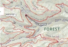
–Download PDF/Photos below-
Portland Parks & Recreation says a landslide in Forest Park has closed Leif Erikson Drive, resulting in a closure of the gravel road that is popular for biking, hiking and running.
According to PP&R spokesperson Beth Sorensen, the road is now closed between milepost 7 and milepost 7.25 and is not expected to be reopened until repairs are completed in October.
Sorensen sent us these photos of the slide taken by park ecologists earlier today:
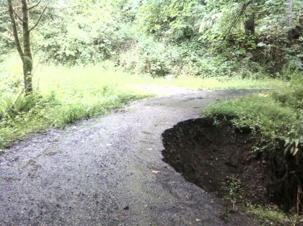
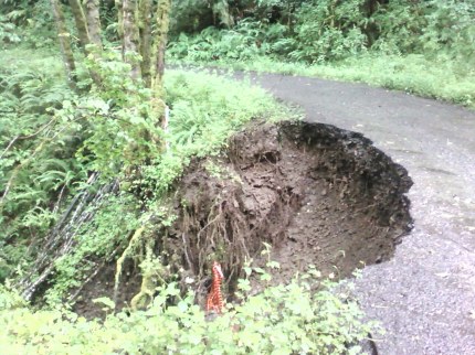
Sorensen says the slide occurred at milepost 7.11, which is about a 1/2 mile south of the St. Johns Bridge. There’s a culvert at that location that PP&R already planned to replace this year. Recent heavy rains were given as the cause of the slide.
For people biking in the park, the suggested detour (if heading north on Leif Erikson) is to head up Firelane 5 Saltzman Road to Skyline Road and then descend back into the park via Springville Road. A map showing the location of the slide and proposed detours has been made available and can be downloaded here.


Thanks for reading.
BikePortland has served this community with independent community journalism since 2005. We rely on subscriptions from readers like you to survive. Your financial support is vital in keeping this valuable resource alive and well.
Please subscribe today to strengthen and expand our work.
Friggin Obama.
I think that there might be a typo or just a mistake here. Folks should take saltzman up to skyline and then springville back down to Leif Erickson. FL5 is a tough single track climb while saltzman is a relatively easy jeep road.
James, I don’t think you can blame Obama for this one even though it is possible that this could be caused from an oil leak. I think it is Sam Adams fault.
agree w/Jocko – the idea of climbing firelane 5 on a regular basis sounds unappealing to most – saltzman is a much better choice here.
Never mind Obama– how can we find a way to blame this on mountain bikers? I mean, Leif Erickson Drive was a pristine old-growth wilderness untouched by man until just moments ago…
BP, sunflower my mountain bike tire. I mean that’s just terrible. Do you think Forest Park could get its portion of Gulf Coast recovery funds, cause it impacts use until October n all.
I am pleased to see that a sense of humor can still be found on BikePortland!
I agree, it is not Obama’s fault, but he needs to fix it NOW! I am contacting the local teabaggers to see if we can somehow get this on Fox NEWS. Proof that he doesn’t really care about us.
How long until the rest of Leif Erikson slides down the hill? I’ve been noticing a lot of water running down the road’s surface in the last couple of weeks.
Oh good-grief! Why close that? I suppose there’s some remote possibility that’ll settle more, but c’mon. A closure? Heck, looks to me like that’s exactly what Ma Nature is doing here. Repairing it. Asphalt is less than, ahem, natural anyway, yo. That’s ‘repaired’ in my book!
I agree with Vance, give it a bit to dry out maybe and stabilize but it doesn’t seem like that will need to be completely closed in July/August when the thing will be dried out.
That’s what you get for cow-towing to the bike lobby. I bet there was a biker there at the time and mother nature was trying to exact her revenge! That’s ok though, this makes FP all that much more pristine.
Cost effective repair:
Signs on both sides of affected area stating “All users proceed at their own risk!” with small print absolving any local authority of any liability for their failure to reverse the natural geological process.
Could use the Falling Stickman” sign as well.
So you can’t bike through there, but you can still hike through there with your (off-leash) dogs?
You guys are way off base with your blame-game-playing. Obviously this is the fault of those kids who graduated the Safe Routes to School program. They should never have bombed down that grassy hill! In Overlook Park!
Pllleeeaaassseee!!! Just ignore the closure and pass at your own risk. If you need a babysitter to tell you if its safe to walk or ride you bike then stay home. Darwin rules!
Keeping weight off of it until they get a chance to fix it means the chances it’ll get worse (read: the chances the city will have to spend a lot more than they will as it is now) will be minimized.
The anti-mountain bike crowd probably sabotaged the trail to fail so they’d have a better arguement for banning bikes from Forest Park.
Damn those rogue hydraulic miners.
IT’S A CONSPIRACY!!!
Closure to foot and bike traffic? Is there more of an issue there than the photos show?
Someone who uses this route and lives in Portland (neither for me) should ask why the closure for 3-4 months. Sure looks like the managment of the hazard would be pretty straight forward and the trail could be opened.
I recall reading that the reason the City has Forest Park is because back in the late 1800s, much of what is now FP was sold off for development. The land was cleared and soon had massive landslides, making it clear that this was view property, but not residential view property. Soon the County had much of it abandoned on tax rolls and it finally ended up in City hands.
Point being, landslides are nothing new here. That there are more is what amazes me.
just ride wildwood…. isn’t that okay? wait… this isn’t the 80’s….
Pedalpalooza Landslide Ride
Any biker/walker who can’t negotiate around this little sinkhole should probably stick to the Springwater. Sounds like a lawyer’s decision to close it for 4 months. Four Months!?! Is that because city engineers can’t figure out a temmporary repair to keep it open for the most used period of the year? Unbelievable! Portland!
And the detour map: That was as clear as mud. I like the idea of signs warning of the danger and allowing people the chance to make an intelligent decision as to whether they should risk it or not. Give us as break; we’ve all got brains. Jeese! And if a few fall into the hole, that’s just Darwin illustrated.
They probably want people to stay off it so when the rest of the road falls away there won’t be anyone on it who would get hurt.
Roads built on hillsides in rainy areas frequently have this problem– especially when said road is built over a culvert that isn’t doing its job to divert water.
Just be smart, people. If you decide to ignore the road closed signs, and the road falls away with you on it, you forfeit your right to be mad about it or to get anything from the city and the parks dept!
It’ll take four months because that’s how long it takes to work through the repair options: junk shot, top kill, containment dome, etc.
I rode on that section a few days ago when it was still open…that is one scary land slide…I was coming around the corner and then there just is a sheer drop of about 15ft…had to ride back past it on the way back to the car!
dam those pedestrians!
Wow 15 foot drop? More slides will make that singletrack. Friggen Obama
Putting up a barrier to prevent someone from going into the hole, plus a bunch of orange/reflective cones, and some warning signs is all that is needed to allow people to keep using it. Neck it down to a one lane so they stay back from the edge. Cut some bushes and push the trail back into the bushes if that is necessary. Closing the trail for such a minor problem is stupid.