-Slideshow below-
(Photos: Adams Carroll for BikePortland)
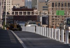
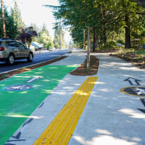
The Morrison Bridge project is getting ever so close to completion. Once complete, it will have a separated lane for two-way bicycle traffic and a completely new ramp down to Water Avenue on the east side.
We noticed significant progress on the markings and the pathway construction so we sent out our new ace photographer/reporter/intern Adams Carroll out this morning to take a closer look.
Adams was able to get up onto the lift-span in the center of the bridge to bring you photos of the new material being used on the lift-span (concrete would be too heavy). Also in the slideshow below, you’ll get an excellent feeling for how it might feel to ride on the new pathway.
According to Multnomah County spokesman Mike Pullen, the path was supposed to open in mid-December. But, as of this morning, he’s heard that it might be delayed a bit (we’ll keep you posted). In addition, the County says they’re working on a video they help will explain exactly how to ride across the bridge (this development alone raises some red flags for us — shouldn’t it be intuitive enough to not need a video?).
Because the new path has two-way traffic and is only on one side of the bridge, it could present some interesting challenges and conflict points if it’s not clearly understood where to ride.
For example, Pullen says westbound bike traffic will be sent down the cloverleaf ramp to Naito Blvd instead of continuing onto Alder which is one-way in the opposite direction. If our calculations are correct, that means westbound bike traffic would have to cross over eastbound bike traffic at some point. It will be interesting how/if this and other potential conflict points will be worked out.
For more photos and captions, watch the slideshow below (and welcome new BikePortland intern Adams Carroll!):


Thanks for reading.
BikePortland has served this community with independent community journalism since 2005. We rely on subscriptions from readers like you to survive. Your financial support is vital in keeping this valuable resource alive and well.
Please subscribe today to strengthen and expand our work.
Hmm. Are those bicycle-car bollard separators finished? They look like they’d do some serious damage to an non-caged bike rider in a crash. A simple cap on them might mitigate.
Can’t wait for this to open. Provided the off ramps are fairly easy and straightforward, this could be a nice relief to the congestion seen on the Hawthorne.
Between the first picture above, the westbound traffic being routed onto Naito, and the existence of an instructional video, I wonder if westbound bike traffic will be on the left side of the path.
When I moved to Portland, the Hawthorne bridge was closed for extensive repair and renovations (for around one year) and the Morrison had a temporary bike lane. I wish I could remember the configuration. As I recall, it didn’t seem too complicated, at least not enough to warrant watching a tutorial video. Like this one, it spit you out onto SE Water Ave on the east side and you “boarded” by climbing the spiral ramp.
The westbound traffic on the west side of the bridge shouldn’t be a big deal. Eastbound traffic coming from Alder will have to yield to westbound riders, just as they do when you’re headed eastbound on the west end of the Hawthorne Bridge now. Once you get past that point the folks heading east will stay to the right, the folks heading west will stay to the left.
It seems likely that most traffic will be heading westbound in the morning and eastbound in the evening so this probably won’t be much of a factor. Nevertheless, it will probably take a little getting used to (just as the one way bike traffic on the Hawthorne Bridge did all those years ago).
As I remember from the design plans it really does need an instructional video. It has some non intuitive things similar to the way to you get onto Williams from the broadway bridge. Worse there is a place where the traffic flow is supposed to do something like switching from riding on the right side of the road to riding on the left side. Wouldn’t have been such a problem with the levels of bike traffic years ago when the plan was created, but it will probably be at capacity in the first 6 months, and I bet they will have to revise things quickly.
Nice photos, Adams! And I especially appreciate your eye for detail.
Apparently the bicycle symbol was installed backwards. Oops.
More photos here:
http://www.flickr.com/photos/gregraisman/sets/72157622701989495/
Lookin good! Will be great to get some breathing room on the Hawthorne once the Morrison path opens.
Awesome report on this, thanks guys!
Looks amazing!!
Concerned about all of the potholes on SE Water Avenue, which is about the most awful street to bicycle on, surface-wise, in Portland. I wonder if some repairs could happen on it, in light of the drastically increased bike traffic anticipated.
That pothole shown in the slideshow photo #11, of the left turn bike lane, could swallow me and my bike !!
Good job Portland. Always nice to have a safe designated bike path. Thanks for the extra pics too Steven
The route will be a great addition.
Generally I am tough to stir up regarding infrastructure not being “cushy” enough for cyclists, but I agree those metals posts appear a little wicked. A simple fall at even eight miles per hour, and if you hit it right, one of those posts will be slicing through your face or torso. Maybe it is not complete and there will be a railing on top, of course with a separation, where the bridge moves.
This looks great – we can thank the bridge & trans folks at Multnomah County for this, as well as the (now-non-existent) MultCo Bicycle & Pedestrian Citizens Advisory Committee for pushing for this.
yeah, this will be great once it is complete, brilliant images.
Regarding those nasty looking metal posts
From the Multnomah County Morrison Bridge Bike/Ped Improvement Project page – http://www2.co.multnomah.or.us/NewPublic/EntryPoint?ct=6ed11a3c7d0d1210VgnVCM1000003bc614acRCRD&cpsextcurrchannel=1:
“On the drawbridge span, the contractor will soon install a two-tube crash-resistant metal guardrail between the path and traffic.”
Of course the page shows as being Last Updated: August 27, 2009; it’s always possible we are seeing a short term budget reduction (materials) in trade for a long term budget shortfall (lawsuit/settlement payouts).
The Morrison Bridge project presented some real challenges. Like many mid-century transportation projects, the bridge was designed to move cars and trucks. It’s really almost an extension of I-5 and the ramps on the north side are what make it impossible to put bike/ped facilities on both sides… and leaves us with the challenges of managing two-way bike traffic on the new path.
Then the fact that a straight path would lead westbound riders directly into oncoming traffic on one-way eastbound Alder St. means we’ll have pay attention as westbound riders take a left to head down to Morrison as riders from the east come up the approach. This design went through review by both city and county bicycle committees and other cycling groups. It was the best everyone could come up with given the challenges of the original bridge design.
The video was suggested at a meeting of the Multnomah County Bicycle & Pedestrian Citizens Advisory Committee as one of the educational tools to help cyclists make the best and safest use of this (best possible, but still imperfect) retrofit to a structure built for a different era.
One note… the Water avenue ramp and intersection was redesigned, so it should work much better for people who bike or walk than it would have if the path had just been tacked on to the old route.
And there will be guardrails along the length of the bridge. One of the cool design solutions was a guardrail that folds when the lift span goes up.
With just a bit of courtesy and alertness on our part, we’ll have one more welcome option for cycling across the river.
The lesson that should be learned from the popularity of the Hawthorne Bridge is that when you directly connect the downtown grid and the eastside grid, bike riders love it. You ride directly from a major street to another major street. The east side approaches serve as cross-traffic-free bike freeways.
The Morrison Bridge project does not have that essential feature. It connects bike riders to points that are merely near the eastside grid and the downtown grid. The east connection is especially inconvenient, compared to the Hawthorne. No bike freeway there. Riders will have to deal with stop signs, cross traffic, and railroad tracks.
“…panels of fiber reinforced polymer.”
Isn’t it great that roadways that are exclusively for bikes can be constructed of much lighter-weight materials than would have to be used for motor traffic? Don’t know whether “fiber reinforced polymer” is any cheaper than concrete, but it sure looks like it can be laid down at much less labor cost than concrete.
I would like to see an analysis of the increased capacity (in person-crossings per day) afforded by this project vs. total cost. Then see that compared to the increase in person-crossings per day (assuming something like 1.5 persons/vehicle) afforded by a similar improvement to the motorway.
Please note the photos are of a current construction site. The project is not finished. Horizontal railings will be attached to the “wicked” posts on the lift span before the path is opened to the public. The posts will be part of a crash-worthy railing.
Any word on what’s up with the rail lines on and near these on ramps? Are they to be covered up?
Excellent photos, thank you.
This is the long awaited, last project initiated by the County after the BTA pushed for making the Hawthorne Bridge safer for cycling (the sidewalks used to be just 6 feet wide). the County, under chair, Beverly Stein, responded with a study of ALL the County’s bridges. What seemed at first to be an avoidance of action, actually led to the improvements on the Hawthorne, Steel, Burnside, Broadway and now, at long last, with funding from Metro, the Morrison. Just wanted to give a shout out to those who so long ago started this all in motion.
rex