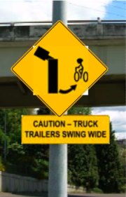
this one, although it’s not finalized)
on downhill side of N. Mississippi Ave.
is among several bikeway
improvements planned.
(Graphics: PBOT)
The City of Portland’s Bureau of Transportation is set to install new signage, pavement markings and a new travel lane for bicycles on N. Mississippi Avenue.
It’s been over a year since Bureau of Transportation staffers painted temporary bike lane symbols on the uphill portion of N. Mississippi Avenue from N. Graham to Cook streets.
Their plan was to put that stretch of road on a diet, removing the existing center turn lane to make a new 6-7 foot wide traffic lane for bicycles in the uphill direction.
But when months passed and the temporary symbols wore off, it was clear that the project had hit a snag. Back in April of this year, we inquired about the project and PBOT staffers said that their Maintenance Operations Group — which has a truck and equipment yard adjacent to the project area — objected to the plans.
PBOT’s Jeff Smith has been managing the project. He told us in April that, “When they [maintenance staff] saw it laid out there, they were concerned about the safety of downhill cyclists.”
The hill is a key north/south connector for folks who don’t like the high-speed motor vehicle traffic and narrow bike lane on N. Interstate Avenue and for whom N. Williams is too far out of the way. PBOT estimates that 350 people bike on the hill each day.
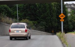
veers downhill and to the right.
Since April, Smith and PBOT engineers have been meeting with managers at the maintenance yard to try and hammer out a solution that addresses the needs for bikeway improvements while also alleviating their concerns.
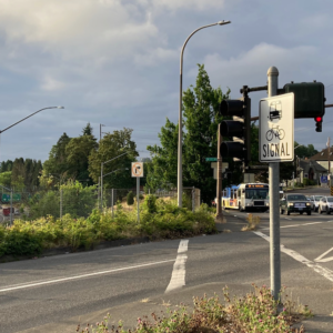
Primary among their concerns was a blind corner (see photo at right) on the downhill section that is also where trucks slow down and stop to turn left into the yard. They felt that people on bikes ride so fast down the hill (PBOT studied the speeds and found that 85% of bikes went 24.4 mph, about the same as cars) that they might run into the back of trucks waiting to turn left (remember, the center turn lane would no longer be there).
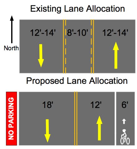

in the downhill direction, just
prior to a sharp and somewhat
blind right-hand turn.
They were also worried that with PBOT’s proposed lane configuration (see it above), someone on a bike might try to squeeze by on the right of a stopped truck, and could be hit when the truck swings wide to enter the driveway.
Along with those practical concerns, there is no doubt that the fatal bike/truck crash two years ago at the nearby Greeley and Interstate intersection still looms large in the minds of both drivers and managers at the facility.
Even with those concerns, PBOT engineers and bikeway planners have come up with a solution that all parties have agreed on.
Along with the new lane configuration, a warning sign and a pavement marking will be placed prior to the blind corner in the downhill direction.
PBOT expects the project to be completed by the end of August.




Thanks for reading.
BikePortland has served this community with independent community journalism since 2005. We rely on subscriptions from readers like you to survive. Your financial support is vital in keeping this valuable resource alive and well.
Please subscribe today to strengthen and expand our work.
So no lane on the uphill portion going north? Or am I disoriented?
Why not bike lanes on both sides of the street?
I am surprised at how much time has been spent on this project. I ride up and down that street everyday on my commute. I don’t find it to be dangerous at all.
Maybe they should look at the rest of Mississippi St if they really want to solve problems.
you might be disoriented, or maybe the graphic wasn’t clear. i’ve just added a “North” arrow. hope that helps. and yes, the bike lane is on the north, uphill portion.
The thinking is that the hill is steep enough that bikes go the same speed as cars so there’s really no need for a bike lane. I ride this every day and I agree with this.
So am I… but when your own agency has diagreements, concerns, it sort of makes it hard to strong arm them and/or do something they are not comfortable with.
I think PBOT gave much more attention to the concerns of their own maintenance group than they would have if it were just some random private company/business they were dealing with.
Brot, the bike lane is northbound (uphill) only.
Also, the exact sign design is still to be determined – we hope to have it finalized in the next week or so.
“The thinking is that the hill is steep enough that bikes go the same speed as cars so there’s really no need for a bike lane”
absolutely right – in addition, even a 6′ wide bike lane can become difficult and/or uncomfortable for a cyclist to stay in at these speeds (25 mph or so), especially with some curves thrown into the mix.
A bike lane on the downhill would be more dangerous, forcing a cyclist to stick to a narrower path just when they are ripping along and perfectly capable of taking the lane. Not to mention you want to swing wide on the way down since there’s a spot to the right where trucks like to pull out.
Having lived in NoPo for 8 years, I’ve ridden that hill both ways thousands times and have had only 2 incidents, both times with drivers being deliberately idiotic. (There was the time I almost gotten taken out by chicken bone thrown by a dog walker, but that’s another story)
A bike lane going up would be nice; but hardly a pressing need. The signage is pointless and in my opinion, takes eyes off this short twisty section of road which is where they should be.
Given that money spent here can’t be spent elsewhere, let’s keep this to a minimum.
(and that yellow warning sign is insanely unclear)
So, PBOT crews outlined the only two scenarios I can think of where a bicycle might pass a parked, er I mean, stopped truck under the new treatment. PBOT crews apparently object to both. What then are passing cyclists required to do in this circumstance? Wait for the trucks to turn?
Am I missing something or is the new treatment going to impede bikes where there was none before? Also, do PBOT crews generate 350 trips per day on this public property? If not, then why does the road signage require 350 people to adjust to a few, when the impetus should be on the trucks in the first place to be vigilant; and in the second because they are a minority mode on the route?
I also agree with tonyt that this seems a lot of energy for not much gain, and possibly diminished access for cyclists to boot.
Very true with speeds on the downhill side, I agree with the reasoning. Thanks for the response JM.
I concur with Vance and Tonyt. Let’s put this silly project to bed and move on already!
Well said, folks. If there were a bikelane on the downhill portion, I would never use it.
Will there be any supplimentary signage for the southbound lane or sharrows?