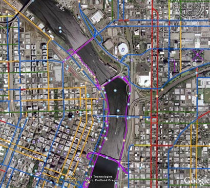
It’s been two years since I first pointed out that Metro had made their awesome Bike There! map available for use with Google Earth.
This cool technology allowed you to get a 3-D, satellite photo view of Portland overlayed with the latest bike routes (and caution areas). You could do flyovers of your commute, explore and research new routes, and lots more!
The map was recently updated, so that meant a new file (Google Earth reads the .kmz file format) was needed to make it all work.
This morning, a reader (thanks Thomas!) forwarded me the new file and just a few minutes ago it popped up on Metro’s website. Below is another screenshot I snapped while playing with it this morning:

It’s easy to get this set up on your computer. Here’s how:
- Download the free Google Earth application onto your computer.
- Then download this .kmz file of Metro’s Bike There! Map.
- Open Google Earth on your computer, and then from within Google Earth, go to File > Open and open the “bike_there.kmz” file (that you just downloaded).
- Use the dashboard in Google Earth to fly over the region. Tilt, pan, zoom, play around and geek out all you want!
If anyone has questions, feel free to ask in the comments. Metro’s map guy Mark Bosworth reads the site and will likely check in and get you some answers.
")
 one hotel on Broadway that embraces the bike lane and those who use it")

")
Thanks for reading.
BikePortland has served this community with independent community journalism since 2005. We rely on subscriptions from readers like you to survive. Your financial support is vital in keeping this valuable resource alive and well.
Please subscribe today to strengthen and expand our work.
Does the kmz file still chug along as slowly as the old one? The prior one slowed Google Earth to a crawl.
Great file, though – nice to have that map married with Google Maps\’ features.
The map shows SW Grabhorn Rd. I _really_ don\’t think it should. For a long time my daily commute took me over that hill and it is _not_ bike-friendly. No shoulder whatsoever and too many turns to see what\’s ahead mean many cars get piled up behind the bikes.
I\’ve even been passed by cars while in my car. This road is dangerous enough to drive on but biking there is irresponsible.
If I took the old maps route, I would have made 30 turns by the time I got to the Interstate bridge, when I only need like 4. Hope this one works for everybody.
Very cool, is there one for Seattle?
Anyone interested in creating their own bike maps in Google Earth can do so at http://veloroutes.org, fyi.
I wonder how they determine the categories , like the kmz categorizes holgate and powell both as caution areas, yeah ok, but holgate is easily ridable whereas powell is absolutely not ridable.
I downloaded the .kmz file and it rocks on my Google Earth, not slow at all. I dig it and even used it to plot a new route home from work today.
Thanks!
This has been unavailable on the Metro site for a bit. I still have the old file; if anyone wants a copy post to the forums.
Hi q’Tzal, would you send me the file richardnys@clackamas.us. Thanks!