
An exciting extension of the 40-Mile Loop route in Troutdale is nearing completion. Reader Frank Stevens shared images of a newly paved path along the Columbia River just north of Blue Lake Park. The new path, which was officially named the Ch’ak Ch’ak Trail by the City of Troutdale in October 2023 (the name means Bald Eagle in the Chinuk Wawa language) hardens an unimproved dirt road that some cyclists have enjoyed for years.
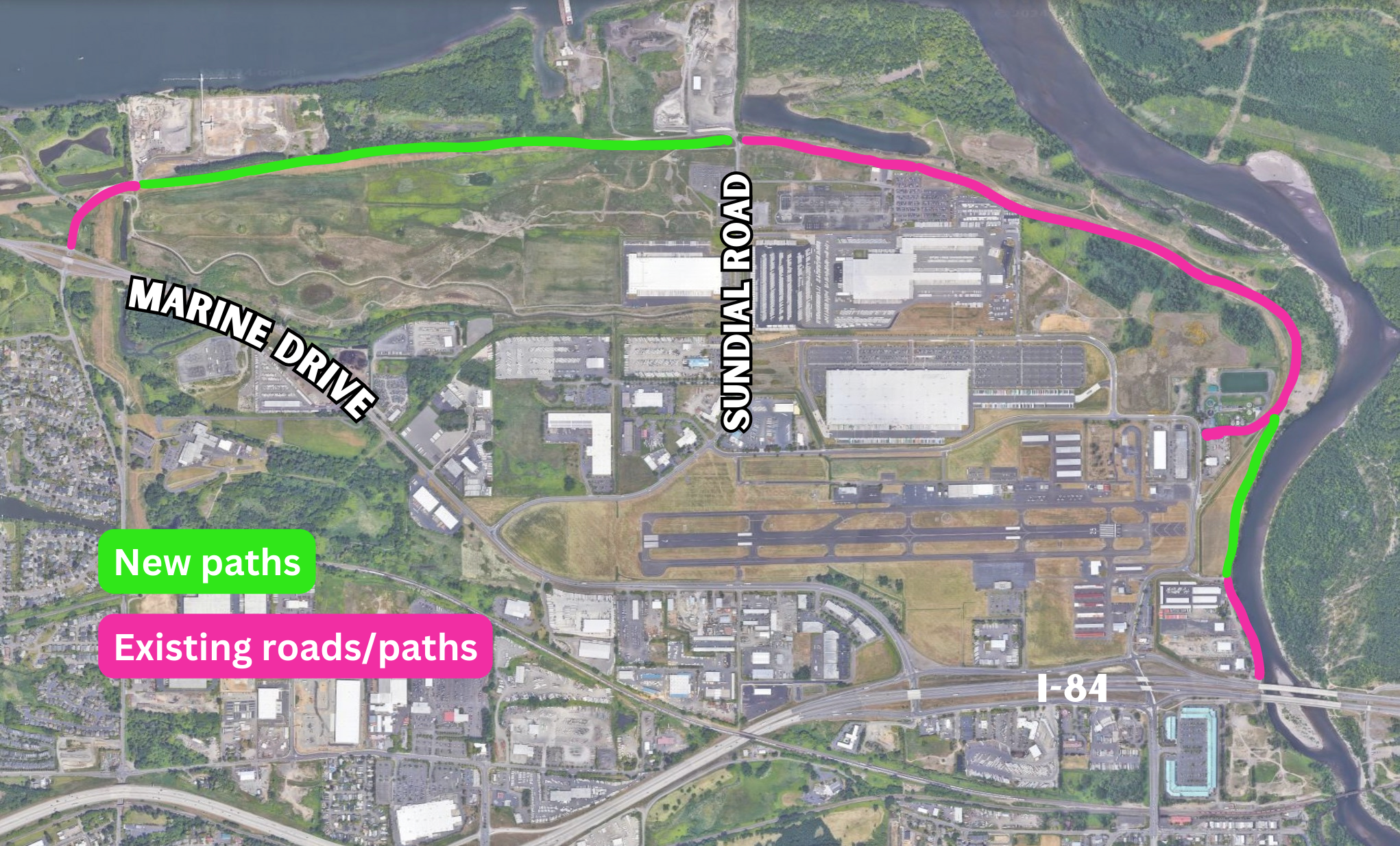
As BikePortland reported in 2016 when the project was first developed, this connects a gap in the 40-Mile Loop and includes a total of 2.1 miles in new paths: a 1.8 mile segment from Blue Lake Park to Sundial Road (see green lines on map), and a 0.3-mile segment near Harlow Road adjacent to the Sandy River. The new sections of path connect to existing paths to create a three-mile connection from NE 223rd Ave to NE Harlow Road and I-84 where it crosses the Sandy River.


Most importantly the newly expanded path gives bicycle riders a safe, carfree alternate to NE Marine Drive, NW Frontage Road, and Graham Rd — all of which are high-stress, busy roads with a large volume of truck traffic.
The project is part of the Portland of Portland’s Troutdale Reynolds Industrial Park (TRIP) development. The path is funded by the Port, Oregon Department of Transportation, and the City of Troutdale. The 700-acre site used to be an aluminum plant and now the Port wants to create an industrial zone that the EPA says will support 3,500 jobs. The Port of Portland owns the property, which is adjacent to the Troutdale Airport.
According to a Port spokesperson, paving was completed last week and finishing touches and signage should be installed in the next few weeks. No official opening date has been released but it should be sometime in June. A grand opening celebration is being planned for September. Stay tuned for exact details.
In related news, a separate project will connect this path directly to downtown Troutdale. The Sandy River Greenway Trail will connect to the existing path under I-84 along the west bank of the Sandy River. Construction on that project is expected to begin this summer.


Are they planning to uninstall that dog prior to the official open?
Nice Hot Black Asphalt..why did they not die this stuff Green or paint the giant mural over then whole thing..why not build these trails out of the pervious concrete…
Asphalt is about half the cost, and works well for pathways with light vehicles and potential root intrusion. It’s a lot cheaper and easier to fix root damage on an asphalt path.
On one hand, RIP local gravel ride.
On the other, that pavement looks buttery and beautiful!!! Great location, too.
It really was a great gravel connection. Super easy, super fun, and only slightly hidden. I’m more curious about that large block of riparian habitat (owned by the county?) between the industrial sites. It was hidden before, but now per usual I’m guessing folks will drive into it with the nice new asphalt path.
I am sad to see that beautiful double track disappear. But, I am reminded that the double track would disappear in tall grass every year around this time because of how infrequently they mowed it! I had a comical slow-speed crash there a few years back when my front wheel caught the edge of a hidden rut and sent me over the bars into the deep grass. I just disappeared out of sight!
I guess there’s still the little strip of gravel to the west along the levee from 223rd to Chinook Landing road to Marine drive?
Not to pooh-pooh this new trail, I’m as excited for new MUPs as anyone, I swear. But when are they actually going to connect this area to the rest of the city? I’ve looked hard and long for ways to ride there without riding on shoulder-less high-speed roads or busy truck routes and haven’t found a way. Why not connect the Gresham-Fairview trail to this MUP (and therefore the Springwater Corridor)? Why not connect the I-84 trail to this path? Why not make it so you can bike from Fairview to Blue Lake regional park or from Salish Ponds to the Columbia? Why not make it so you can use MUPs and/or greenways to get to the Historic Columbia highway and therefore to the Historic Columbia state trail? Why not make it so you can use this MUP as part of a continuous and safe way to get from Gresham to the Gorge to camp or hike or just bike for funsies? Or to Larch Mountain? Or to the Sandy River Delta without having to drive? Right now the only way I’d use this is to put gasoline into my car and drive it to the trailhead and then ride my bike and then drive home.
Marine Drive has several egregious gaps, and the road is really dangerous. The I-84 path effectively dead-ends at 181st, and the Gresham Fairview at Halsey. The trail gaps in east country are so frustrating, because we are so so close to a connected, safe network, but our City and County leaders choose not to prioritize active transportation.
I think BP reported awhile back that improvements to the gap on 201st between I84 and the Fairview trail were upcoming, not sure if that’s still the case. The transition at 181st still is terrible but its hard to envision any headway in such a forlorn stroad-fest.
Is there any modern connection with the Chinook tribe in this area/project? When does land recognition naming without any actual reparations or involvement/historical name/reason just become more cultural appropriation…? Like, if the tribe doesn’t call this trail that, why are others? This larger project is just repurposing an old ecologically damaged area for other *less* (hand wavy) ecologically damaging things, right…
Someone w/ CTGR helped name it
BradP, the City of Troutdale brought in a Chinook member and language expert to advise them and help come up with the name. It was adopted by Troutdale City Council in October 2023.
Bummer. This segment felt like a little secret. Every time we pave something our rides get duller.
I agree completely. I love those un(der)known spaces. When the wild gets tamed, it gets ruined. And we need wild spaces, it rejuvenates us.
Like the Springwater on the Willamette from Oaks Park to under the Burnside Bridge, much better when you were jolting along on the ballast from the rr trax & “weren’t supposed to be there”. Never did I then encounter a clueless ped with their dog on a too long leash begging to tangle you up or the inattentive ped walking on the wrong side with their entirely clueless child wondering from side to side of the path… ugh
finally! A few years back when I rode on, it was really in bad shape. I had fun riding it.