(Map by Google)
Sometimes, you just have to stop reading the signs.
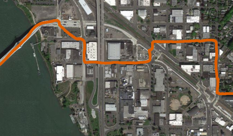
That’s the advice from BikePortland reader axoplasm, who responded to Tuesday’s post about the hassles of navigating to the east landing of Tilikum Crossing with a homemade route of his own that he said is “slightly longer” but “much faster, with simpler crossings and saner stoplights.”
Here’s his take on the situation, starting with a reply to an observation from Justin C., the bike commuter who wrote most of Tuesday’s post.
(Axoplasm refers to a series of numbers we used to identify the issues Justin identified. You can keep track of them here if you’re interested.)
“It’s as if someone thought of connecting the bike route to the bridge via Tilikum Way but then decided against it…here’s the reality: We’re hoping for signal timing to make a bad route slightly less bad.”
THIS. A good guide to sanely using the Tilikum is to assume the bike signals are steering you AWAY from a good path.
I take this bridge routinely from approximately the same place as Justin C. I’ve found that the crossings are much better if I actively disregard signage & wayfinding (but not the law). The clean crossings are all there, but Tri-Met is trying to steer bikes away from them.
For example, avoid (1-2-3) altogether by turning north on 12th (the sidewalk works OK if I’m with my kids), crossing Division, turning west on Caruthers and then crossing Division (again) and the tracks at SE 8th (4). This is a straight shot over the tracks and the light is more sanely timed.
Then, avoid the jog onto Tilikum Way (5) a poorly-timed light at Water (7), and a second light at the Max station by skipping the bike lane and riding west on Division Pl to 4th, then turning left on Caruthers & crossing through the Opera parking lot. Only one crosswalk light, which is almost always green.
Advertisement

Despite being slightly longer this detour is much faster, with simpler crossings and much saner stoplights. And it is 100% legal.
Even better is to avoid Division altogether by crossing the freight tracks on the new Lafayette/Rhine bridge just off 21st — especially if you’re coming from the south (Holgate). In this case, avoid (again) the bike-only signals, particularly at 12th/Milwaukie, by jumping into the street on Gideon. (This does require proceeding straight through the intersection onto the trail on a right turn arrow)
There are similar shortcuts on the westside. For example, slow to walking speed & get out of the bike lane at approximately Elephant’s deli. Then use pedestrian signals to cross the tracks and/or Moody. Do this on foot if it’s congested. Even at a walking speed, it’s usually faster to walk than following the bikelane into the weird gooseneck at Moody & waiting through two or even three signals.
Interested in shortcuts like these? If you’re a BikePortlander, you’re in luck. Our new monthly email newsletter Street Beat will feature a “route of the month” that features clever, useful or beautiful tricks and secrets like this one for making your way efficiently and joyfully around town.
If you’re not a BikePortlander yet, get on it! The first edition of Street Beat goes out next week.
Yes, we pay for good comments. We’ll be sending $5 and a little goodie bag to axoplasm in thanks for this great one. Watch your email!

")


Thanks for reading.
BikePortland has served this community with independent community journalism since 2005. We rely on subscriptions from readers like you to survive. Your financial support is vital in keeping this valuable resource alive and well.
Please subscribe today to strengthen and expand our work.
The best part of bikeportland – people who not only pay close attention to how they get around, but then report on their successes (and failures) right here so the rest of us can learn! And let’s hear it for autonomous route-finding unencumbered by taxpayer funded experts!
This is kind of hilarious and sad. But a cool idea of an alternate route. The bike lights are indeed setup as if to make a cyclist stop at as many points as possible. I imagine many people just ignoring them in the future unless they get them worked out better.
I also supplied an alternate route over on Transit Sleuth when the train backs up the area here -> http://transitsleuth.com/2015/10/29/union-pacific-bicycle-re-routing/
I wonder what an engineer (or citizen) from den Haag or Groningen or Amsterdam or any of a thousand European cities would make of the contortions required of the unmotorized here?
I think it’s something like “Bike map? … hahahaha!”.
I approve of this new feature!
21st has no bike infrastructure and aggressive motorist traffic in the am. This is a bike route for the cycling “enthusiast” who is already part of the 7.1%.
Huh? This route doesn’t include 21st.
‘Protected’ bike facilities come at a cost of convenience, directness and speed, and don’t improve safety for cyclists in the least, at least in the good ol’ USofA.
If y’all don’t get it yet, this is really all about getting cyclists out of the way of transit AND motorists, and not about making anything better for cyclists.
No… its about a $2 billion project treating cycling like an afterthought.
Which is entirely true, the bridges purpose was for expanding Trimets (specifically light rail and likely the up and coming rapid bus services) services. It was never designed to be a bicycle bridge.
IT’s design is near perfect for its intent, and we should be thankful that they added bicycle and pedestrian lanes, they very likely could have not designed and built them in at all.
Bike stockholm syndrome.
Thank you, soren. My thought exactly.
Thankful!?!
I actually enjoy riding on 21st, and have yet to encounter an aggressive driver there, even in the AM. To each his own, I guess.
I enjoy riding on Chavez/Division and any aggressive drivers I encounter provide adrenaline rush-tinged amusement.
To each his own???
I strongly believe that the personal preferences of enthusiasts like me should not inform bike routes and bike infrastructure.
You’ve got some balls of steel for taking that route at any time of day. Chapeau!
I meant 12th.
Axoplasm does mention taking the sidewalk on 12th when biking with his kids… not that that’s likely to appeal to the “interested but concerned.” Maybe to the “VERY EXCITED but concerned.”
So Williams has its problems. I look at it as a work in continual progress. But I also see SE 12th as a good candidate for a Williams style design.
Yes. I sometimes take 11th Southbound from Sandy/Ankeny to Clay/Hawthorne in order to avoid the congestion on the Vera Katz MUP. The downhill S-bound direction is good. A Vancouver / Williams style single lane couplet with wide bike lanes would be great on 11/12 from the Orange Line cluster at Clinton to Ankeny/Sandy.
Of course, as soon as they put it in, it will be followed by 5 years of construction of new condos and 5-story apartments along the whole section, then the inevitable mushrooming of new traffic signals, weird cycle routings and tracks, stop signs, beg-buttons, bike traffic lights, and …. you get the picture – all legal bike traffic will slow to a snail’s pace.
Ah, ok… that makes more sense.
Yeah, I was gonna say, 21st is great.
When an article has to be written to instruct riders how to avoid a brand new million-dollar bicycle facility, you know there’s a problem with your planning and transportation agencies.
Not enough room in the budget for a test bike. Granted, when a government agency or contractor buys a bike, it costs $10k.
Offer at least some well thought out suggestions as to exactly how you believe the east side street route approach to the bridge could and should be laid out.
It’s way too easy for people to complain about difficulties they’re having with the route, without making the slightest effort or offer of suggestions to help figure out how the route might be done better for everyone.
Many commuters optimize for speed. I optimize for lowest stress. Here are my stress points w/ axoplasm’s route: Riding 12th. Crossing Division. Twice. Playing peekaboo at 11th and Caruthers. Riding through the onramp area under 99.
The new infrastructure is a disappointment. I run the occasional mis-timed light. But it’s better than the other routes I used to take and I feel less stress overall so I roll with it. YMMV
I use low stress routes for every mode, especially driving… drivers are horrible so when I have to join them I try my best to avoid them…
So how far out of your way does a low-stress route have to take you before you will abandon it for a higher-stress route or just not make the trip? I think planners of “bike infrastructure” (or as it increasingly seems to be implemented, “peasant infrastructure”) are counting on (i.e. assuming) this tendency in all bicyclists. They assume bicyclists will go anywhere they tell us to go, no matter how slow, confusing, inconvenient, or out-of-direction it might be, as long as we’re told “it’s safer” (even if it isn’t really safer). To be clear, there is NOTHING WRONG with desiring and seeking out low-stress routes, but why can’t a low-stress route also be designed to be direct and convenient? Because bicyclists are treated like peasants. “You’ll take it and like it, because it’s all you’re gonna get.”
I agree. Low-stress and convenient needn’t be at odds.
Cyclists will go 26 percent out of their way to use a separated path and 18 percent out of their way to use a bike boulevard.
http://ppms.otrec.us/media/project_files/Bike%20model%20brief.pdf
The fact that there are people out there (wearing orange vests) to explain how to navigate the system speaks, to me at least, volumes.
At one point, waiting for the light to cross 11th/12th, they suggested that we put our bikes in the green box, on the bike symbol, and wait for the green bike crossing light, which you really can’t see from there. By habit, we were looking at the lights across the street. This light is on the west side of the street (with us), and angled towards the sidewalk.
I ride SE 12th daily as part of my commute (from Gideon to Grant). I would never recommend this to someone who isn’t VERY comfortable riding side by side with motor vehicles and taking the full lane. This includes my bike commute savvy children and my non-biking mother. As much as I dislike the way we are “supposed” to go as cyclists (and clearly I disregard that way daily, myself), it is the only way I am comfortable riding with my kids, or if I were directing new riders or people from out of town, etc.
That said, SE 12th really isn’t bad re: taking the lane in that there are two lanes of traffic, plenty of room for people to pass you in cars, and most people give plenty of room. But it’s those occasional cars that pass you within inches (when there is no reason)…. It’s much better than SE 17th south of McLoughlin (which is also part of my daily commute), where there are no other options.
Reposting from the other day: Another route that works!
–
This is how I’ve been getting through there (I’m actually headed up to the Hawthorne, still, but this route would get me to the on-ramp to the TK at the fenced off sound sculpture right under the bridge). Note 1: I take the sidewalk along Powell for that section, though one could ride in the right turn only lane, as there’s usually little traffic at speed. Note 2: if you’re like me and have a strong dislike of waiting around for red lights at empty intersections, one can simply enter the westside sidewalk midway up SE 8th, round the corner (on the sidewalk) onto Division Place, all without putting a foot down, and rarely having to wait for southbound traffic on SE 8th. Then, one simply exits the sidewalk onto the auto lanes of Division Place. Fast and efficient, because it gets one from the neighborhood to the bridges without a single red light!
https://www.google.com/maps/dir/45.4933746,-122.639243/45.506746,-122.663425/@45.5027041,-122.6622414,1401m/data=!3m1!1e3!4m34!4m33!1m30!3m4!1m2!1d-122.6469317!2d45.4973285!3s0x54950a7dd1c2ec41:0x3ee45d59267cf39d!3m4!1m2!1d-122.6531349!2d45.5009416!3s0x54950a7bb44441d7:0xeb85fd0faaf60be0!3m4!1m2!1d-122.6542936!2d45.5021215!3s0x54950a7a6932d5c7:0x7871622cc84e2052!3m4!1m2!1d-122.6578175!2d45.5021352!3s0x54950a7079b0266d:0x353fa1a0c0ed0d25!3m4!1m2!1d-122.6595038!2d45.5048787!3s0x54950a7105b6c565:0x1aeaf52b52c19b73!3m4!1m2!1d-122.6644579!2d45.5059468!3s0x54950a7216cd7a33:0x4129139aa3182f8e!1m0!3e1
This is the most efficient route I’ve found through the area, too. I stay on the road where 17th merges into Powell, and sometimes can go straight across Milwaukie if the light cooperates and there is no bus, but I’ve learned to watch out for left-turners from Powell onto 9th north-bound. Also watch for drivers veering into the bike lane on the west-bound Powell on-ramp.
I mentioned this in response to the comment in the original post, and I think it’s worth reposting here:
(The opera parking lot and eastbound bridge intersection) actually represents a huge hazard that I think none have yet mentioned. This light (the one facing the opera parking lot) is usually green, but there is no light (facing) the intersection with the eastbound bike lane, where people riding off the bridge are likely to still be travelling quickly. The sightlines for both are difficult at best, and the “mixed signal” that users reach coming from both directions could easily, if it hasn’t already, lead to a collision.
I would caution users from both directions to slow considerably and be on the lookout here until/unless something is done about it.
Yes! This is a HUGE hazard. The light only refers to crossing the tracks, but once the tracks are crossed, as one turns left onto the bike path, the east bound cyclists have no warning. This will result in injury.
There is actually a place on this bridge without a light?
Fairly shocked.
Another lost opportunity in that they didn’t construct a MUP path both ways when building the street car crossing to the North.
Oh well, number 1 biking city to some. Yet…when millions are being spent, a few bones for bikes/peds…just can’t be found.
I hope that PBOT will step up and publicly state that this is poorly designed, substandard biking infrastructure.
I was going to say this last week, but will now. Everyone ready?
Bike access to and across Tilikum Crossing would have been much
betterfaster and direct if it was open to private automobile, and painted with a standard, non-exceptional bike lane.So….why can’t we design a bike-only route with the same care and attention that we would give to a car-permitted route? In theory, it would be easy: design a route for cars, then close it to cars. During construction, you could pretend cars were really skinny.
Comment of the Week!
This is exactly the irony of having the most modern bridge in America that as planned is absurdly antiproductive.
This is part of the reason I am against diverters on Clinton St., which don’t solve the problem of the reason drivers choose Clinton over Division in the first place.
This is why citizens must choose their political leaders carefully.
As a side note, my home address does not exist in Trimet’s database, so I can’t even plan a route from my own home to wherever else. Better luck next time, Trimet.
This discussion reminds me of the ridiculous routes I’d take through Seattle in the ’90s to avoid highway crossings, interminable lights, and unnecessary hillclimbs/descents.
Really unfortunate that the planning behind this project could not accommodate sensible traffic management for bicycles.
Unfortunately you have to set the bar incredibly low when it comes to cycle infrastructure in the USA. Portland is a great biking city ONLY if you accept the fact that it’s going to be a total maze, and the best routes are the ones the individual discovers for themselves through trial by error. (I actually like the challenge…)