(Graphic: Better Block PDX)
Starting this Friday morning, the non-profit Better Block PDX, the Bureau of Transportation and its commissioner-in-charge Steve Novick will embark on perhaps the boldest experiment we’ve seen in years: the creation of public space on Naito Parkway in what are currently standard travel lanes.
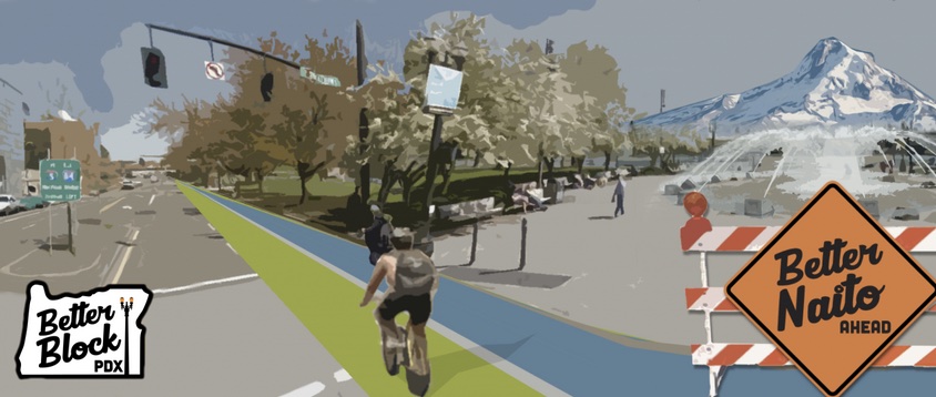
For two weeks starting early this Friday morning, the four standard vehicle lanes on Naito Parkway between Southwest Salmon and Northwest Couch (about a mile) will be converted to three lanes and a 15-foot wide lane that will run in the northbound direction adjacent to Waterfront Park.
But don’t call it just a temporary protected bike lane or a sidewalk.
“I think it’s a cultural shift for PBOT. Instead of looking at streets to move people and goods as fast as possible, they’re looking at streets as public space.”
— Timur Ender, transportation policy advisor for Commissioner Steve Novick.
“This is Janette Sadik-Khan style public space. It’s ‘8-80’ for everyone,” explained Timur Ender in a phone interview yesterday where he referenced two heroes of public space: the former New York City Department of Transportation leader widely credited with that city’s inspiring urban streets renaissance, and Gil Peñalosa of 8-80 Cities who sees quality public spaces where people of all ages and incomes mingle as the cornerstone of democracy.
Ender is Novick’s transportation policy advisor who has helped spearhead the Naito project (he’s also a former volunteer with Better Block). “This pilot project shows PBOT’s efforts to use their streets in a way that fosters economic development, tourism, and public health,” Ender added. “I think it’s a cultural shift for PBOT. Instead of looking at streets to move people and goods as fast as possible, they’re looking at streets as public space.”
Ender emphasized the “streets as public space” has long been a priority for PBOT staff (see events like Sunday Parkways or programs like Street Seats), but the Naito Pilot Project takes that focus to a new level.
Ryan Hashagen with Better Block says the project builds on historical Oregonian values. “Our plan envisions a Naito that more efficiently allocates space, builds on the legacy of Governor Tom McCall, and continues a conversation started by the governor on how best to utilize our public resources and space on the waterfront.”
For Commissioner Novick and PBOT Director Leah Treat, this project is a coming-out party of sorts. They entered their positions with high hopes from change-minded transportation activists but they’ve been bottled-up by the battle over new transportation revenue.
Advertisement
I have a feeling both of them are looking forward to today’s press conference to announce the project which is scheduled for 1:30 pm at Salmon Street Fountain. Alongside them at that event will be the project’s other partners including the Oregon Chapter of AARP and Oregon Walks.

(Photo: Timur Ender)
This project also has the support of Rose Festival organizers. According to Ender in Novick’s office, they “fully embrace” the project and have worked with vendors to minimize loading times (which have traditionally blocked the lanes on Naito) and trained their security guards to manage traffic in the temporary lanes.
PBOT spokesman Dylan Rivera said his agency sees the project as a way to improve safety and make people feel more at ease on the Waterfront. “We made some observations of the pedestrian and bicycle conflicts on Naito during the recent Cinco de Mayo festival and that underscored the need for more space so people can access the festival. This is about making a more comfortable space.”
The impetus for the project was two-fold. The non-profit Better Block PDX, fresh off their successful demonstration that transformed 3rd Ave through Old Town saw Naito as a natural follow-up project. And Commissioner Novick’s office wanted a solution to the dangerous situation that develops each time the Rose Festival sets up in Waterfront Park.
Earlier this month we shared Novick’s concerns. “We are very concerned with the conditions we saw on Naito this past weekend,” he said, “Kids in strollers and seniors were within inches of 35mph traffic without any physical protection.”
As for the space itself, Better Block has received a $10,000 grant from Clif Bar and People for Bikes to help buy materials and the project was designed as a Senior Capstone Project for a group of Portland State University civil engineering students. To create the new lane, they’ll use candlestick wands and other standard materials called for by the Manual of Uniform Traffic Control Devices (MUTCD).
At 15-feet wide, the lane will be about 50 percent wider than the Hawthorne Bridge path and the pavement will have similar markings to help separate bikers from walkers. Bike riders going northbound will be welcome in the new lane and those riding southbound should use either the Waterfront Park path or the existing Naito bike lane. In another experiment, during the final few days of the pilot project during Fleet Week, PBOT and Better Block will make the temporary lane open to both directions of bicycle traffic.
Another way this project is taking a page out of Sadik-Khan’s book is how organizers will gather data to measure and monitor traffic and livability impacts. PBOT has already placed bluetooth traffic sensors on Naito at Clay, Salmon, Stark and Davis. The sensors are measuring the existing amount of people walking, biking, and driving on the street. Those numbers will offer a good comparison to traffic during the pilot project. There’s also a video camera at Yamhill and Better Block will do manual bicycle counts at the same locations PBOT has done their annual bicycle counts in order to compare results. Better Block volunteers plan to observe traffic behaviors and make notes of how people and their vehicles interact with each other.
Ender says data will be key in helping PBOT gauge the projects impacts. But public feedback could play an equally important role. The City, Rivera says, sees this as a “creative public involvement tool.” Instead of an open house and posterboards, they’re just putting the vision on the street and asking for the public’s feedback. They’ll monitor social media, phone calls (to 503-823-4321), and emails closely to make sure they’re hearing from the community.
They’ve created a campaign around the hashtag #BetterNaito to try and corral all the buzz.
Number-crunching will be important, but in the end, good public space is about people. “Unofficially,” Ender said, “we measure success by smiles. Are people safe? Happy? Are they having a good time?”
With so much support (even Mayor Charlies Hales is an unabashed supporter of a new lane configuration on Naito), the question on many people’s minds is: If the pilot is a success, then what?
Both Better Block, Novick’s office, and PBOT were very careful to not answer that question when I asked it yesterday. Ender replied by saying, “The City has no agenda here. It’s premature to say we have a course of action… We don’t even know if people are going to like it.”
And how will Naito’s drivers handle the decrease in space to operate in? “The public is already used to some disruption during Rose Festival,” PBOT’s Rivera said, acknowledging the hectic nature of the street during the festival. “We think it could be a little less pleasant for people driving during rush hour.”
But like many streets in the Central City, there is plenty of excess capacity that could be put to more efficient use, so major “carmageddon” isn’t likely to happen. “We wouldn’t do this if we thought the sky was going to fall,” Ender said.
— Check out PBOT’s official website for this project (will be live this afternoon) and remember to use #BetterNaito to share your thoughts when it opens to the public on Friday morning. Better Block is hosting a volunteer meeting tomorrow (5/20) at 6:00 pm at SW Naito and Ankeny. Please show up if you can help. They especially need cargo bikes for Friday’s set=up.


Thanks for reading.
BikePortland has served this community with independent community journalism since 2005. We rely on subscriptions from readers like you to survive. Your financial support is vital in keeping this valuable resource alive and well.
Please subscribe today to strengthen and expand our work.
This is exciting! I hope there’s enough positive feedback here to lead to something permanent in the months ahead.
Yes! I use Naito as a bike freeway in order to get to 3rd and Burnside fast.
Fast Bikes Use Naito Bike Lanes
Super pumped about this! I’d love to see it last through the summer. After Rose Festival there is Pride, then there is brewfest, then there’s 4th of July, etc.
Pretty much all summer Naito should be like this.
And then…all year round!
I envision where Naito Parkway, is used for festival tents and high pedestrian areas during festivals. Then they could allow the grassy areas to remain grassy areas.
It has always caused me to cringe when I see that beautiful grassy area beaten down to dry dirt, event after event.
This is taking the Waterfront to the next level! The People level!
Anybody know how much Parks spends on grass restoration versus how much revenue the festivals bring in? I never assume that there’s a net positive for the City in these things.
Fortunately, we live in an optimal climate for grass growth. The Willamette Valley is the grass seed capital of the world!
http://oregonstate.edu/valleyfieldcrops/grass-seed
Not certain, but I believe festival organizers must pay to reseed the park on top of their permit fees.
Although I’d prefer to see a northbound and southbound cycle track on both sides of Naito, this is still a great idea to help promote car-free space and more protected bike lanes. I’m excited to see how this pans out.
The cycle track will be two way from June 3-5th!
Perhaps defining them as temporary projects gives the city license to do bolder designs without opposition, and, once in place, shows potential opponents that their worst fears did not come to be. Then, it becomes easier to make an existing project permanent than to put in a permanent change in the first place.
I’m really happy to see this. These are the kind of projects that—if they make them permanent and if they keep doing more of them at different locations—that will start to put us back on track.
Well said.
The “pilot method” is the way to go. I hope they are working behind the scenes on other locations in the city. Maybe even push the envelope a little and remove some parking.
Yes! This is exactly how NYC transformed Times Square. And, as I understand it, the amazing success of that bold move gave them the political will and public buy-in to keep going. It was important to start big, with a high profile, popular, and much-visited site. Start small and cautious, with minor sites, and it seems like you’d be fighting the uphill battle with neighborhood naysayers every single time.
But start with Voodoo Donuts and the Rose Festival, and bam! You sell it to the world.
But then there comes a point when the naysayers have been proven wrong so many times that they no longer have to be listened to. Why is Portland still giving voice to these people? Why is Portland conjuring up opposition to fixing Clinton St, or allowing the 20’s bike way to be derailed? Hopefully the success of this project might mean that the seat at the table for reactionary car-heads might get pulled. But, let’s see.
What’s being proposed here is pretty amazing when you consider that there used to be a freeway running here. It was torn down to build the Waterfront park, with Naito Parkway as the compromise replacement. It took 40 years, but we’re literally going from a freeway to a livable space with no major replacement roadway. This is living proof of what can happen when you flip induced demand on its head. Inspiring.
I-405 was built after the Harbour Freeway was removed.
And Front was turned into a boulevard (Naito). Also, Harbor Drive as a “freeway” is a bit misleading, as it wouldn’t be considered a freeway by today’s standards. Pretty similar to what Naito is, today, if I understand correctly.
Point still taken, though, William.
I wasn’t around in those days, but my understanding is that 405 came first. See here:
http://www.cnu.org/highways/portland
and here:
http://en.wikipedia.org/wiki/Harbor_Drive
Even if it came before, it’s a fair point that removing Harbor wouldn’t have happened without 405. Still, the city felt that widening Front into Naito was necessary at the time, and now we’re seeing that maybe it wasn’t.
Nope. Harbor (not Harbour) Freeway removal/Waterfront Park was completed in 1974. I-405 was built in 1969.
The building of I-405 and I-5 directly contributed to the declining use of Harbor Drive. While certainly commendable that the city removed a highway, it’s not as if they removed a heavily-used one.
Tearing out I-5 on the other side of the river; now that would be a bold move.
“Tearing out I-5 on the other side of the river”
….will never, ever happen because federal DOT regulations would require a significant expansion of 405 to accommodate the Increase of traffic. I know it’s fun to daydream about, but it would literally require an act of Congress, which is run by a party hostile to liberal ideals.
We’re pretty much stuck with I-5, and thinking the federal government will dismantle highways at the whims of Bikeportland is pretty delusional.
Based on what we’re seeing right now at the federal level regarding highway funding, I’m not sure if the federal influence is going to be a factor in another 10 or 20 years. All it would take is a libertarian-leaning president and a conservative Congress to dissolve the Federal Highway Trust Fund completely and leave it entirely up to the states.
All all the Ron Paul supporters would get what they want. Garbage.
Doubt it, though. Like with the railroads the Interstate Commerce interests would have a few words.
Re-sign I-205 as I-5. Force people driving through Portland to go around the central city.
I’m happy to see some action happen here in non-glacial time. It could be so much more and sooner. Portland needs to let go of this notion that the sky falls if people have to get out of their cars (in the rain… gasp! I’m melting.)
With speed posted anything over 20mph, plastic bollards and 15ft width isn’t enough to make a pleasant, safe space. Especially if the traffic is moving at 40mph here. Who should get maimed or killed to save you 90 seconds driving through a park?
Posted speed limit reductions would be a nice addition to this project, but in my experience of daily use along Naito during festival season, car traffic is rarely moving at anywhere near the posted limit. That stretch very often is so crazy and half blocked off with festival related stuff that nobody gets through it very quickly.
Why would more signs slow speeding drivers?
If they were put in the middle of the road, maybe. 🙂
Instead of an open house and posterboards, they’re just putting the vision on the street and asking for the public’s feedback.
This. This is the way to do it. Finally, the City catches on to what Sadik Khan accomplished so brilliantly in NYC: a low cost, high value way to get community feedback and gather data. The posterboard open houses I’ve been to, though well-intended, were little more than sounding boards for the most vocal. Counting “smiles” among people simply out using the facility, and gathering actual traffic data on the spot, seems like a far more valid way to arrive at best solutions.
Sorry about the unclosed tag…
If I read my google search results correctly, Harbor Drive was state highway 99W at the time it was removed, at which time 99W was moved onto Naito. Naito was transferred to the city in 1989.
“builds on the legacy of Governor Tom McCall, and continues a conversation started by the governor on how best to utilize our public resources and space on the waterfront.””
It’s about time we kicked life back into Tom McCall’s principle of “Underutilized roads get turned into public space for people”
Even though this is just repurposing one lane on a street (rather than repurposing a whole highway, like Harbor Drive was), it’s a great precedent for Portland Moving Forward.
Nice work Better Block, PBOT, and all others involved.
Ted Buehler
&, for folks not familiar with the history of Harbor Drive and Governor Tom McCall, take a look at a sampling of Harbor Drive images available on a Google image search —
https://www.google.com/search?safe=off&site=&tbm=isch&source=hp&biw=1588&bih=1068&q=%22horbor+drive%22+portland&oq=%22horbor+drive%22+portland&gs_l=img.3…1781.5155.0.5267.23.10.0.13.0.0.101.893.9j1.10.0.msedr…0…1ac.1.64.img..15.8.726.4vCnl67GdEk#safe=off&tbm=isch&q=%22harbor+drive%22+portland&spell=1
You can see that where Waterfront Park now is, there once was a highway.
It was a gutsy and forward-thinking move in the 1970s to tear out that highway and turn it into a park.
Think of Downtown Portland today with a highway there instead of Waterfront Park. There would be zero connection between downtown and the river. No summer festivals. No jogging. Just another clogged up highway that costs $ to own and maintain. Instead we have a crown jewel of downtown livability.
Now, take a look at those Harbor Drive images and think of all the underutilized road space in Portland today — in smaller terms but with hundreds of examples. 4 lanes where there could be 2. 2 lanes where there could be 1. Secondary neighborhood streets that can be vacated for a half block to make a park. And start clamoring for the spirit of Tom McCall to be reborn for a 21st century de-streeting of the city to leave an equally fabulous legacy to our posterity.
Ted Buehler
“21st century de-streeting of the city” is a wonderful phrase!
Thank you to all those who help make this happen! Nice work!
What happens when Rose Festival needs the space to unload trucks this year?
The new temporary path will be blocked from time to time. Organizers are asking for patience from walkers and bikers when trucks are present.
…or they can put cones up and convert the 3 main lanes into 2 main lanes and leave a path for walkers & bikers. Wonder if they’ll have the guts to do something so crazy.
So it it the same as the MUP are on the other side of the park against the water. The same where they say “fast bikes use Naito”? I guess what I’m asking is, does this mean that fast bikes will have to opt to still mix it up with cars, but now actually share the lane with them? If so, it seems regressive.
Never mind. The pertinent information was much farther down the page:
Nice!
Dedicated signalling for bikes entering & exiting the Oak and Stark Street bike lanes onto Naito would be good.
Did anyone catch the dates for the temporary project? When does this change start and when does it end? Just curious, I ride there a lot.
May 22 to June 5th.
If this became permanent, would we get physical separation from the roadway?
Also, please please give us a corkscrew offramp from the Morrison westbound bike lane that ties to the northbound Naito bike lane.
Define ‘physical separation’.
Buffered bike lane – probably.
Vertical delineators – probably.
Curb – doubtful.
Most of that Morrison ramp is going away when the James Beard Public Market project gets built.
Thank you, thank you, thank you PBOT for skipping the open house/ poster board phase and going for it!
Better Block PDX has a volunteer form up on their webpage for anyone interested. I guess I’ll be putting my muscles where my mouth is on Friday.
Whooooop! Super stoked for this.
I remember when Naito (aka Front Avenue) was being rebuilt about a dozen years ago, and the so-called Portland Freight Committee (staffed by PBOT) demanded that lanes be widened so semis could move comfortably, no concerns for the longer crossing distances that imposed on those on foot. Their concerns were met! Time to dissolve the PFC, which is a publicly supported lobbying group for more and faster roads.
Bravo to PBOT for this repurposing of Naito, if only for two weeks!
Lenny, I’m interested in learning more about this Portland Freight Committee you mention. I have never heard of such a thing. Does is still exist? Do you have any more information about them? Thanks.
Here’s info from the PBOT website: https://www.portlandoregon.gov/transportation/54899. They are an advisory committee to PBOT. There are also bicycle and pedestrian advisory committees.
Oh right, thank you Kate.
I really hope they make this permanent, and then find a way to extend it to the north and south. There’s a nice new section of MUP between Lincoln and Harrison, but then any kind of bike specific infrastructure disappears entirely for the 7 blocks between Harrison and the Hawthorne Bridge. At the other end the bike lanes disappear underneath the Steel Bridge, which is particularly frustrating when cycling south (northbound you can use the Waterfront Park paths). Removing one or two general travel lanes here to create buffered bike lanes should be easy given that the road narrows from 4 to 2 lanes north of the Steel Bridge anyway.
Portland Freight Committee, staffed by PBOT, meets the first Thursday of every month, 7am at City Hall…Lovejoy or Pettygrove Room.
Okay, thanks.
Smart drivers avoid Naito northbound during festival times, so this trial is in optimum conditions. By reallocating traffic lanes on streets defined as having excess capacity, the city is essentially engaged in a citywide traffic slowing enterprise as drivers will keep seeking out alternative routes until all arterials move at the same slower speed (see the classic essay on The Law of Rush Hour Traffic Congestion by Anthony Downs). How the next 100,000 Portlanders fit with this goal is not clear, but there will certainly be tensions along the lines of the apartments without parking spaces conflict.
Great! I’m pretty sure people will like it.
awesome, could have used this the past few days. I cant wait!
This sort of lane reallocation is exactly what ODOT should have done on SW Macadam north of the Sellwood Bridge, instead of forcing everyone on foot or bicycle to share a meager sidewalk dangerously punctuated by utility poles and other hazards. Even though there is more than enough capacity for northbound car & truck traffic (indeed, the biggest problem here is speeding in the construction zone) ODOT repeatedly refused to consider using some road space for the bike/ped detour during construction of the new multiuse path along the river north of the bridge.
Fortunately, no one has died here and I haven’t heard of serious injuries, but the detour is one of the most despicable sections of ODOT road, once again exposing the agency’s failure to adhere to its oft-stated commitment to safety.
This. Absolutely. The construction means that there is no combination of traffic from 43 and from the Sellwood bridge onto Macadam north of the bridge–now the two traffic flows only proceed one at a time past the bridge. So keeping two lanes, which arguably accommodates the combined traffic from both simultaneously, is pointless.
But hey, dodging light poles and grazing handlebars sure makes the ride exciting.
Then go and remove the other 3 (4 if you include the turn lanes) lanes as well.
That whole stretch of road isn’t really that necessary.
Aside from the Hilton loading zone (which incidentally I’d say you let them keep the access but only available from traveling north ), I can’t think of any business that relies on it from Hawthorne to Steel for automobile building access. Most the traffic on it, is rush hour, and most of it is people trying to skirt other roads or backed up bridges downtown.
This sounds great, I can’t wait to try it out!
Not to sound cynical, but it’s a strong bet that this “public shared space” will end being dominated by the homeless people. This in turn helps make Portland a great tourist destination to help generate revenue for the city because everyone knows tourists love mingling with people looking for handouts.
Is that what has happened to SW Ankeny by SW 3rd Ave?
I was there last week and there were several homeless milling around, but nothing out of the ordinary.
In Corvallis they dropped the fees for the city buses. But now my parents complain that homeless people ride around all day. Must be a universal issue.
It’s Friday morning, and i’m looking at the execution of this project from my 4th floor office window. Channelling vehicles into one lane on northbound Naito looks like a complete cluster-event; it’s one giant rush-hour traffic jam. Feature, not bug.
Unless you are willing to take the lane on the Steel Bridge, NB Naito is now pretty much the bike lane to nowhere. Without signage or notice the lower deck is closed for Fleet Week.
Also hearing from a co-worker that uses it for her commute that government vehicles are parked in the two-way bikeway anyway.