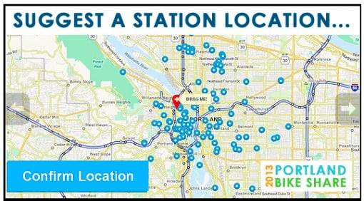
The City of Portland is putting the pieces in place for the new bike sharing system they say is coming in spring 2013. On Friday (without any fanfare at all), they launched PDXBikeShare.com, which gives us our first look at how PBOT is marketing the program and, more importantly, marks the launch of an interactive station locator tool.
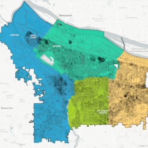
The social-media enabled tool allows anyone to place a red pin where they want to see a bike sharing kiosk location. Users can then create a station name and provide a description of the location. Other users can comment on station locations, share it on Twitter and Facebook, or email it to a friend. The map view can also be filtered for popularity. Here’s how one of the four entries received so far looks…
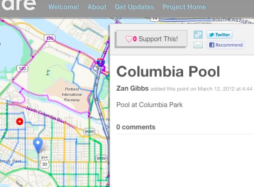
I can already imagine that many of the suggested stations will be in outlying neighborhoods (where most people live), even though the system itself will be focused on the Central Business District. This could end up giving fuel to arguments from equity advocates who have been pressing PBOT to serve areas beyond downtown with the new service.
As for how PBOT is marketing Portland Bike Share… Look at these beautiful, smiling people seen on the web site:



The new site is also interesting because it shows how PBOT is framing the program to the public (a public that that is sure to include a lot of skeptics). In a newly expanded FAQ, the City makes the case for bike share:
Having a bike share system means giving Portlanders an efficient, sustainable choice. Our region has a comprehensive and safe bikeway network that bike share customers can use to cover short trips quickly. Bike share riders will move throughout the city without adding to road congestion and parking demand, while improving air quality and personal health by forgoing a car trip. Residents, business owners and travelers want bike share to come to Portland for all these reasons.
And the question of “Who’s paying for it?”:
The City and its Transportation Bureau are not committed to purchase or operate bike share, but are managing the grant award and facilitating the selection of a private sector vendor to operate the system…
The FAQ page doesn’t address the thorny (to some) issue of helmet use; but it does tackle the issue of whether or not a credit/debit card will be required (something that equity advocates have bristled at):
Since this [a bank card requirement] presents a barrier to people who don’t have access to credit, bike share systems in Washington,D.C., and Denver are working on pilot projects to make their services available to those without bank cards. The City of Portland plans to work with a private sector vendor to make bike share available to everyone.
PBOT is expected to release the official Request for Proposals for a bike share system operator any day now. Once the process of choosing a vendor is complete, then the real planning will begin. The system is expected to be up and running by spring 2013.
For more on Portland’s bike share system, see our past coverage.



Thanks for reading.
BikePortland has served this community with independent community journalism since 2005. We rely on subscriptions from readers like you to survive. Your financial support is vital in keeping this valuable resource alive and well.
Please subscribe today to strengthen and expand our work.
This is fantastic news.
For some of the history of the campaign to bring bike sharing to Portland check out: http://btaoregon.org/2011/08/many-voices-speaking-in-support-of-bike-share/ and http://btaoregon.org/2011/12/bike-sharing-moves-forward-with-jpact-approval-of-federal-funding/
I feel like I’m a hostage victim that isn’t allowed to disclose anything more than to say that I’m ok. (Pssst….don’t jump on the bandwagon PBOT)
Hello Folks, the crowd sourcing/interactive bike share station map feature is running slowly right now. Our apologies. We are working to resolve the problem.
I’m excited in the concept of mini satellite bike share systems: Cully, St. Johns, Multnomah Village. I wouldn’t expect people to commute using bike share from these locations, but a small grouping of 4-6 stations would allow for greater neighborhood reach. Bike share can be a part of the 20-minute neighborhood aspiration.
Transit planning has a concept of ‘coverage’ routes, often provided at a subsidy into areas that normally couldn’t support transit. This is done for legitimate reasons such as equity, service area (for funding) or for regional political support. Can’t bike share use the same model? Particularly with the risk of a neighborhood backlash to a central-city only program, a neighborhod based system might ease tension.
+1 this. Bike share makes it possible to hook up with transit, especially given cuts in Trimet that leave a lot of places a mile or more away from stops. Bike sharers might not want to ride from Multnomah Village to downtown, but from Multnomah to Hillsdale? You betcha.
Woah, approve a private bike operator, come up with the implementation logistics including all the stations required, and up and running within one year? That would make this the most well managed public transportation project in history. Especially since a little thing like FUNDING has yet to even be determined.
I’m bummed at how sluggish the map is. Perhaps they under-anticipated site traffic?
PBOT has already addressed this in the comment above. I retract my comment.
Our web developer has resolved the issue with the page running slowly. Thank you for your patience.
I recommend that everyone here suggest sites in downtown and other central city areas, since that is the area that makes sense for bike share (due to density and traffic). If you can think of a good spot, due to the wide of the street or a plaza next to the sidewalk, those would be good spots, since the bikes have to have room to fit.
Also, oooh, just noticed the “suggest a location” tool is using OpenStreetMap. WIN!
If it is indeed OSM data then where’s the proper attribution and the CC licence?
That’s a very excellent question; looks like this might be something to bring up. There’s attribution to MapQuest for the tiles, but it’s not linking to the correct site for that either (should be open.mapquest.com, not http://www.mapquest.com in this case). The highlighted bike routes I recognized immediately along with the official names of the major highways, both of which are often omitted or included incompletely or inaccurately in other maps. There was attribution to Cloudmade somewhere, but I can’t find it now. I’ll email ’em and ask ’em if we can get attribution.
Hi Harald and Paul:
We have attribution to Shareabouts on the “About” page. I’ve increased the font size to make it more conspicuous.
We’re grateful to the Open Source community and in particular to OpenPlans for developing Shareabouts .
The interactive map has turned into a bloodbath of red dots. Some areas have been carpet bombed with stations every half a block (and it looks like it was done on purpose, rather than uncoordinated demand.)
Please us the “Support This” feature to indicate increased demand for a location, rather than placing more dots 50 ft away. I feel sorry for whoever has to clean up this data.
Hi NF,
A rather disturbing metaphor, but we get your point. If the points do not have a name attached to them they are not visible. We are working on solutions that prevent robo-entries, though we’re likely to lean on the side of keeping an open forum when the poster’s intent is unclear.
Thanks for encouraging folks to use the “Support this” function. In addition, using the “Filter by Popularity” bar can help remove clutter on the map and see the points that are resonating with participants.
Everyone should brace themselves for national media coverage of this as an example of misuse of public funds. I identify myself as a cyclist and I’ve got to say I agree. You can buy a decent used bicycle these days for $100, or rent one for a pittance if your a visitor to our town. Can someone please explain to me why we are wasting scarce resources on this? It serves to undermine the private sector to befit who exactly?
Please make sure to include a name with your station location recommendations. Points without a name attached to them will not appear on the map.