(Photos: Oregon Parks and Recreation)
This is a big weekend for Oregon’s first rail-trail. This morning, the Oregon Parks and Recreation Department and officials from Washington and Columbia Counties will cut the ribbon on a new section of the Banks-Vernonia Trail that will fill the final gap in the 21-mile trail.
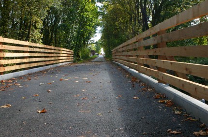
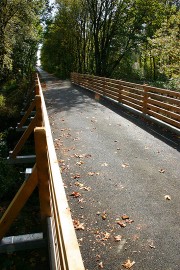
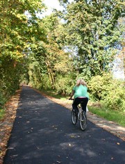
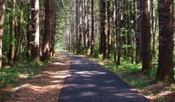
The new, 1.5 mile segment of trail is in Banks near the junction of Banks Rd, Sellers Rd and Main Street. Chris Havel, Associate Director of Oregon Parks and Recreation sent over a few photos of the new path…
At the public ceremony today, Columbia County Commissioner Tony Hyde and Washington County Commissioner Andy Duyck will join Oregon Department of Transportation Region 1 manager Jason Tell and Oregon State Parks and Recreation Commission Vice Chair (and Bike Gallery owner) Jay Graves.
The total trailhead and trail project cost $1.4 million and was funded with $819,000 from a Federal Transportation Enhancement grant, a $411,000 federal stimulus grant, $130,000 in State Lottery Funds, and $20,000 from Washington County.
(Update: Washington County also contributed just under $3 million to repave and realign what Commissioner Dick Schouten refers to “what had been the confusing, odd angled, closely spaced series of intersections of Banks Rd., Cedar Canyon Rd., Sellers Road, Hwy. 47 (Main Street and Nehalem Hwy.) and a rail line.”)
In conjunction with the opening, Stub Stewart Memorial State Park is free to users this weekend and there will be lots of activities going on in and around the park. The Northwest Bicycle Safety Council is leading a ride on Saturday. Portland-based non-profit bike-camping group Cycle Wild is leading an overnight campout to check out the new trail. The ride leaves this evening at 5:00 pm from the Hillsboro MAX station.
For more information about the trail and the events this weekend, check this story in The Oregonian.


Thanks for reading.
BikePortland has served this community with independent community journalism since 2005. We rely on subscriptions from readers like you to survive. Your financial support is vital in keeping this valuable resource alive and well.
Please subscribe today to strengthen and expand our work.
This is GREAT news! Lots of hard work went into this project I am sure.
How do we inform the public learn that these types of project don’t just happen, they need their support as voters, taxpayers, and citizen advocates?
On a related note, what is the status of the Tillamook railroad line trail proposal down the Salmonberry River?
This is a great addition. I rode it a week ago and it is wonderful to start right in Banks. This will be terrific for families.
There is also a bike rental and repair shop that started up right next to the Banks trail head. I spoke with the gentleman who owns it; he says he has been waiting years for them to complete the trail into banks so he could open his shop.
Finally, just in case you were planning to ride the trail this weekend, there is a portion of the trail near Tophill that is still closed for construction. While it didn’t cost as much and didn’t get the publicity, it is the “other” missing link as it was unpaved and had really steep slopes on both sides of Hwy 47 at the Tophill trailhead. According to the Oregon Parks website page for the Banks-Vernonia Linear Park:
“Oct. 14 Update Note: The trail between Tophill and Beaver Creek trailheads will be closed Sept. 20-Oct. 31 for trail construction. The trail will be closed from McDonald Road just over one mile south of the Beaver Creek Trailhead to the bridge over Highway 47 near Tophill, about one mile north of the entrance to Stub Stewart State Park. The Beaver Creek Trailhead is open.”
Now if we could just find a few million $ to rebuild the trestle over Hwy 47 at the Tophill trailhead, that would be really cool.
riding the trail to camp sounds like a lot of fun… next summer… (:
Hmm, this is great, but largely just “completion” for show and ribbon-cutting. This section was easily negated by riding the bike lane on 47 for a mile out of banks. What they really need to do is pave the muddy/rocky off-road trail section in the middle, it’s fun if you are on an off-road bike, but virtually un-ridable on a road or touring bike and has a complicated detour to avoid. When that’s done, the trail will really be a fun, useable banksvernonia link.
Sweet! Good news from all corners today.
Beautiful!
Dave Thomson (#2) – More like a few tens of millions. The trestle is huge, and rebuilding it would be expensive. Unfortunately it’s extremely unlikely we’ll ever see it rebuilt.
Gabe (#4) – I wouldn’t say “easily negated”. Traffic on 47 can be heavy, and that road does not have a bike lane, only a narrow shoulder. The old trail access was 1/4 mile down the road, and the road edge slopes steeply down into a drainage ditch – not exactly bike-friendly. It’s great that there is now a completely low traffic / no traffic route to Stub Stewart.
For those coming camping tonight, please be aware that there is rain forecast for tomorrow and temperatures will get down into the 40s. The ride leaves PROMPTLY at 5pm – if you’re coming, please be at the Hatfield Government Center MAX Station at 4:45pm. We will arrive at Stub Stewart after sunset, lights are required. We’ll be making a 30-minute stop in Banks to buy food.
Hope to see some of you out there.
Could you negotiate the middle dirt section on a cross bike? Or is it rough enough to require a MTB?
Excellent! Can’t wait to go try it out!
@ Matt Haughey
My wife and I regularly ride the whole thing on rigid city bikes with 1.75″ wide tires. We go slowly on the unpaved section, and push the bikes for maybe 100 yards getting around the old trestle, but you should have no problem at all on a cross bike if you aren’t in a hurry.
Matt (#8) – You can negotiate it on any bike, but it’s unpleasant to ride if you have a stiff frame, drop handlebars, and/or skinny tires. I’ll be looking at that section of the trail tomorrow, and I’ll post an update to this thread afterwards.
I’ve ridden the unpaved part on a road bike. It’s not that bad, except for some spots north of tophill where cuttings are flooded and/or landslid (I suppose you could just ride through the mudpuddles, but I got off and pushed.)
The ramps where the trail bypasses the burned trestle are _interesting_, however; both are >10% grades, and there’s enough clutter on them to make them difficult to ride up (and slightly terrifying to ride down.)
I know that finally paving the entire BVT will be nice for a whole lot of people (especially families with kids). But personally, I miss the days when the whole thing was unpaved.
the unpaved section isn’t that bad, and quite a lot of fun. me and a couple friends rode out to vernonia, oh, a month ago, a little longer?, and crews were preparing to pave the unpaved section.
I’m with Jim (#1)–“On a related note, what is the status of the Tillamook railroad line trail proposal down the Salmonberry River?”
Does anyone have more information on this?
Well, too bad I have to work weekends. I would love to go on that outing. Hopefully I can make it out there soon, though.
there is a portion of the trail near Tophill that is still closed for construction. While it didn’t cost as much and didn’t get the publicity, it is the “other” missing link as it was unpaved and had really steep slopes on both sides of Hwy 47 at the Tophill trailhead.
Is this the one “unpaved section” everyone speaks of? Does this mean it is going to be paved?
I agree with comments that the “difficult” piece was the middle around Tophill. I live in west Portland/West Hills and have done this trail several times on many different bikes. On a hardtail Mtn Bike with 2 inch knobbies, had no problems but the rest of the trail was boring for a MTB. On my touring bike with drop bars and 32mm tires, doable but middle part was still a bit sketchy specially on descent near Tophill after rain. On my recumbent with 32mm tires, once I made it but another time, huge rain/mud made traction impossible and I had to bushwack a few hundred feet with the bike on my shoulder cross style to get to Hwy 47 and bypass the section. The last part towards Banks was quite honestly a piece of cake for any experienced cyclist. I wish they had this “opening ceremony” AFTER they finshed the middle section (I hope they finish that soon). I worry that families with kids on road bikes will attempt the whole trail without understanding that the middle is still unpaved and get in trouble.
Anyway, not being a downer, the next interesting piece is the Banks to Scapoose section. I have heard rumors that the Vernonia to Scapoose trail actually kind of exists by now. If true, it would make a sweet century from my house to Banks to Vernonia to Scapoose and back around Sauvie Island! That would be a sweet ride.
Yes, they are re-aligning the trail to reduce the grade and paving it.
I have not been out there to see what it looks like, but it is supposed to be complete by the end of the month (Sunday?).
I found this description in the Oregon Parks and Recreation Commission minutes from May 20, 2010:
Banks-Vernonia State Trail – Trail Improvement Projects
The goal of this project is a trail maintenance that also has funding through ODOT with an
FIP share. The work will consist of re-alignment of the trail from the Tophill Trailhead to
the existing trail at the old railroad grade in both directions. The existing trail from the
Tophill Trailhead is currently very steep. It was built to provide a continuous trail
connection by replacing the partially collapsed Horseshoe Trestle in this area. The trestle is
no longer used and will also be removed this biennium as one of the final projects on the B-V
Trail. The other work will consist of clearing, grubbing, and re-grading of the re-aligned
trail and placement of asphaltic concrete paving on the final three miles of the trail that are
still unpaved; installation of new pipe culverts; and miscellaneous site work as required. The
anticipated cost for construction of all projects is $670,000. The trail projects will bid in late
June and will be presented to the Commission for action at the July meeting
noah, when we were out, the very first bit, the part in banks, that was prepped for paving. farther north, maybe the tophill trailhead?, closer to vernonia, crews were out widening sections, smoothing it out, etc. the whole thing will be paved. and that’s cool, but like i mentioned above, it was super fun to ride unpaved. bumpy, muddy, fun.
Jim, dane – I haven’t heard anything recent, but any proposal on the Port of Tillamook Bay Railroad right-of-way is subject to the approval of POTB. So far, they’ve been pretty active about enforcing their property rights on that stretch, presumably to limit liability.
Does anyone know which group was making the proposal?
How does one ride there from Portland?
Stig10:
see route 1 (blue route), map 1 – shows the route from Hillsboro:
http://www.portlandonline.com/transportation/index.cfm?c=36638&a=301633
I appreciate the comments on the suitability of the trail for road bikes (not quite there yet). Thanks, I’ll ride when its ready. I am sure the fatter tire folks will have a great time.
in my experience, the middle unpaved section is totally rideable on a rando bike with drop bars, 28mm tires, full fenders and luggage. but, skills and whatnot vary, so…
from an entirely selfish point of view, ill be bummed to see it paved, cause *i* think its a lot of fun to ride. but i can see how its likely the majority of people who might use the trail would prefer it paved.
Thanks all for making more upgrades to this facility. It has been an important regional bike touring (with MAX) destination for our kids and other families. (Yes the Banks gap was manageable but it was often hairy for our smallest riders on loaded bikes to leave the trail and try to get up speed to enter traffic gaps.)
As for the unfinished northern section, it is doable with a road bike with modest tire width (28/32mm) if the trail is dry. I have done it several times with a lightly loaded (~10 lbs Carradice Camper bag) single speed bike for rides out to Astoria etc.
FYI – I was a bit shocked at its poor condition vs. the rest of the excellent trail my first time out. I would suggest better advance signage on the trail so that families and regional tourers can turn off before it if they are not up to the slopes at the missing bridge.
Dean M and Todd F – care to share your touring experience with the Banks trail gap? 😉
We’ve included Banks-Vernonia Trail on several bike trips we’ve made to Oregon. It is a really neat trail to ride! It would be great if a philanthropist out there was interested in restoring the Horseshoe/Tophill Trestle!!