

(Photos © J. Maus)
Last Friday a few friends and I decided to ride our bikes down to Monmouth (about 15 miles west of Salem) for the start of the Cycle Oregon Weekend event.
When I checked the map to plan the route, I realized this was a perfect opportunity to test out the state of Oregon’s first fully signed and mapped, official State Scenic Bikeway.
The Scenic Bikeway program was first proposed back in 2004 by (coincidentally enough) Cycle Oregon, but the program is just now gaining speed.

In May, the Willamette Valley Scenic Bikeway (WVSB) found a permanent online home. Now, anyone can print detailed maps of the 132-mile route that goes from Champoeg State Park to Armitage County Park in Eugene. (Hopefully someday the route will start in Portland. Federal money to start planning the new French Prarie bike/ped bridge over the Willamette should help.)
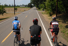
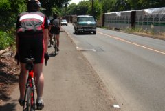
On Friday, we picked up the WVSB just south of Champoeg (the historic Butteville Store makes a great starting off point). With my map in clear view on my handlebar bag, we rolled through the farms and rural roads of the valley, with the snow-capped spire of Mt. Hood keeping watch over us.
A highlight of the first section of the route is the miles and miles of hops fields. Seeing their long vines stretch up and over the interesting cable system used by growers gave us a tangible reminder of Oregon’s flourishing beer industry.
The roads were pleasant to ride on and we encountered very little motor vehicle traffic. Most of the route is on heavy farm use land and we shared the road with more than a few tractors and other farm equipment.
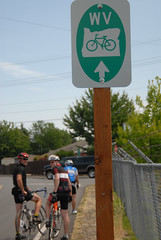
As we pedaled south, I wondered why I didn’t see any of the official Scenic Bikeway signs. Unfortunately, they didn’t show up until we got to Keizer, about 27 miles into the route. I learned later that Marion County has been slow to put up the signs, but that they should be installed in the next few weeks.
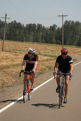
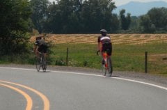
Low traffic made for pleasant riding.
|
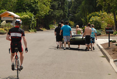
We encountered some kids portaging a huge tube for river floating.
|
Once we saw the first official sign, it was easy to follow the route, even without a map. The signs are a bit small, but they are distinct and placed at every turn. We relied on them to get around and through downtown Salem (I had forgotten to print the map for that section, so we were riding blind).
The route was well thought-out, except for one spot south of Salem where it directed us onto a sidewalk adjacent to River Road where we pedaled against traffic for about 3/4 of a mile. My only other nitpick is a lack of free, publicly available water. How about building a few water bottle re-fueling stations?
Someday, I hope Oregon State Parks realizes their vision for a statewide network of Scenic Bikeways, connecting rural towns and cities with pleasant, well-signed routes that are marketed far and wide. If the WVSB is any indication, this is a program well worth supporting.
For more information on Oregon State Parks’ bikeway program, and to find links to maps of the Willamette Valley Scenic Bikeway, visit the official website.


Thanks for reading.
BikePortland has served this community with independent community journalism since 2005. We rely on subscriptions from readers like you to survive. Your financial support is vital in keeping this valuable resource alive and well.
Please subscribe today to strengthen and expand our work.
When I rode down to Eugene during my spring break, I ended up following a bit of the bikeway. On River Road, I just ruled out that strange section of sidewalk as unsafe and kept right on pedaling on the correct side of the road without issue. Until the bike lanes and railroad crossing of death:
I’m sure you rode over this. For those of you who haven’t, look at the full-sized image and make notes of a few things. Those bike lanes are painted with raised, tactile paint, kind of like mini-rumble strips. I would imagine that it was too keep cars out of the bike lane, but it also makes it even more jarring when a bicycle needs to exit the lane, such as where it tapers down and ends without signage, right before a diagonal grade crossing. And if you weren’t paying complete and absolute attention, you probably wouldn’t have noticed that you needed to get out of the bike lane until it was too late to make it safely over to take the tracks at a right angle. Even if you were paying that much attention, you still probably wouldn’t have noticed it due to the fact that it is located right after a blind curve in the road. Even worse, this makes it impossible to judge where there is a sufficient gap to make it out into the lane.
This is unacceptable on any road, much less the official State Scenic Bikeway.
This is definately a great route! I have rode it twice, once in each direction. There are some nice B & B’s along the way for overnight trips. Check out this great video that Brighton made on our 2008 trip:
http://www.youtube.com/watch?v=zLyHQ5qscng
It looks like the image didn’t embed properly.
Here’s a link to the photo:
http://www.flickr.com/photos/jr98664/3452124060/in/set-72157616967246556
And Google Maps streetview for those who are interested:
http://tinyurl.com/lgyz9o
River Road is horrid. I’ve told city council this- in support of a bridge from Riverfront Park to Minto Island Park. That would provide an alternate route to avoid that nasty section.
The River Road section is one of the MWVBTA top 12 bike projects. The bridge at Minto will be helpful, but may not be so helpful for higher speed recreational riding or commuting. We hope that facilities for both kinds of riding will be built!
There has been talk in the Downtown Vision 2020 bike/ped group about creating a water station and kiosk, and your note is helpful in documenting a demand for it! Thank you!
What a great way to extend the CO Weekend ride – ride there and back or even just one way for that matter.
I may do that next year!
Did you ride back or get a ride in an internal combustion engine vehicle?
An alternate route around it is to cross the river in Salem and take Hwy 22 (which has a ridiculously wide shoulder) to Independence Highway and ride down into Independence. You can then either cross to Riverside Drive or continue south and cross at the Buena Vista ferry.
River Road is unpleasant, but still better than many Portland roads. Still, I look forward to it getting a makeover.
For years, I used sections of this route on rides from Vantucky to visit kids in Eugene. There are places where one rides with farm fields on one hand with the river Willamette glimmering through the windrows on the other, that are some of my all-time favorite riding – anywhere.
Peaceful, well-paved, few & well-behaved motorists, imperceptible grades for the most part, interesting stuff along the way – a ferry ride [is possible – two(!), with a little detour through Canby], parks, agriculture, small towns; a great short getaway/antidote to the big city tour. The bikeway maps call out all the usual stuff like big hills and parks, etc.
As for supplies en route, the towns along the way provide for no more difficulty than the moderate planning-ahead needed for any touring day. It’s a very comfortable two-day trip to Eugene starting at the northern Oregon border (the Interstate Bridge). I have long practiced guerilla camping and there are plenty of opportunities to ask at a farm to do a chore in exchange for throwing a tent by the edge of a field or just cautiously using a park area with concealment; of course, there are motels along the way, too (but it’s such a short ride). Many good places to fuel up the bike engine, too: tacquerias, family-owned diners, a few roadside farmstands at the right time of year.
It’s easy to make a loop of it, traveling down one side of the valley and back up the other. I’ve done it so many times and connected from so many directions (direct through Stumptown, out the Columbia and then down through the coast range and over, etc.) that I kinda ran out of unridden routes and then discovered AMTRAK. For, like, twenty-five bucks, you can hang the bike on the bike hooks in the baggage car and ride back in laid-back style to Portland Union Station on the train!
I love the Willamette Valley along this route so much, it long ago became the standard by which I’ve judged everywhere else I’ve ridden in the country. Pity the kids have moved on from Eugene and removed that excuse for making the trip a few times a year…
Jene-Paul
JM, you should go out to the roads around St Paul sometime in August when they start harvesting the hops.
Man, it smells so good out there!!! 🙂
The Willamette Valley has some awesome roads, and most of the time the car traffic is minimal. I wouldn’t go riding out there around special times of the year, like Memorial Day or Thanksgiving weekends when wine tourers are out in force, or around Mt Angel during Octoberfest. 🙂
Glad to see a report on the WV route, I’ve been interested in checking more of it out!