
(Photos © J. Maus)
If you’ve ever tried to navigate across the I-5 bridge from Portland to Vancouver (or vice versa) you know that it’s not for the faint of heart.
With a disorienting combination of sidewalks, a freeway on-ramp and off-ramp, and several high-speed streets that access hotels and the Janzten Beach shopping center, it seems like it was designed and planned before bicycles even existed (or clearly before they were considered a viable means of transport).
Thankfully, conditions are likely to improve soon thanks to a collaborative effort by the City of Portland, the City of Vancouver, and the Oregon Department of Transportation (ODOT).
|
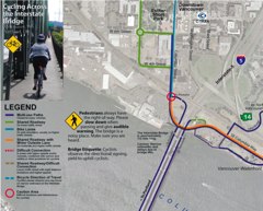
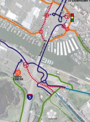
Sneak peeks at new I-5 crossing bike map.
|
Jennifer Campos, a transportation planner with the City of Vancouver, says that over the last few years, she’s noticed an increase in requests for information on how to bike across the bridge and get through the Jantzen Beach and Delta Park areas. PDOT bike map guru Jeff Smith also noticed a demand for an I-5 crossing route information and he took the initiative to create a map — but it has only been available online.
Now Campos says, Vancouver has received a federal grant to improve bicycling conditions and they will use the money on a variety of projects including a new map and improvements for bike access on both sides of the bridge.
For starters, Campos says she’ll use the grant to re-design and print a new map titled, Cycling Across the Interstate Bridge and they’ve hired Portland-based Alta Planning to complete the project. The map is due out soon but you can see a few sneak peeks in the photos above (stay tuned for an update once it’s done).

up on your way to and from Vancouver.
On the west side of the bridge, Campos says they plan to widen the bike path, install an informational kiosk, stripe a dedicated bike turn lane on Columbia and add directional signage. On the east side of the span, plans are in place to fill potholes, stripe the parking lot area with sharrows “to delineate bicycle movement”, and add bike-specific signage (which is part of a citywide bicycle route signage program they will implement next year).
Campos adds that ODOT has committed to making infrastructure improvements on the Jantzen Beach side of the bridge.
For their part, the City of Portland plans to extend their bicycle route signs up into Delta Park and Jantzen Beach.
Campos says Vancouver will spend about $8,000 on designing and printing the map and doing these minor improvements near the bridge. That money is part of a $353,000 grant from the federal Congestion Mitigation and Air Quality Improvement Program that will cover several other bicycle improvements in Vancouver including the citywide bicycle route signage program, new bike parking downtown, striping of bike lanes, and education and encouragement programs.


Thanks for reading.
BikePortland has served this community with independent community journalism since 2005. We rely on subscriptions from readers like you to survive. Your financial support is vital in keeping this valuable resource alive and well.
Please subscribe today to strengthen and expand our work.
Some fresh pavement through Delta Park would be nice, as well.
While I\’m happy and grateful for any improvements, the key (and expensive) issue is the width of the bridge crossing itself. Of course that\’s a major infrastructure change but it\’s the primary issue.
Signage will be helpful to allow new riders to negotiate the maze.
Eeeeeeeeeeeeeeeee! That\’s so exciting!
I\’ve had my share of trying to navigate through there after dark. It\’s hard in the daytime, and near impossible at night.
Hurray! Seriously, that\’s just damn awesome.
I\’m with Lester, some fresh pavement through Delta Park would be a big improvement. Some of those potholes are difficult to see in the rain/dark.
Awesome! I have been wanting to cross the bridge, but quite frankly just haven\’t been able to figure it out from the available maps (and I haven\’t felt brave enough, or had the time enough, to just go explore). This is sorely needed!
heh, I\’ve ended up on that red dashed line many times trying to bike back from the expo center at night. It\’s harrowing as hell, but I can never find the right paths in the dark. Some lighting and/or improved markings would help.
HI Tonya and others who are curious about crossing the bridge…please email me if you would like to join a future \’RU Bridge Curious\’ guided bike tour of the crossing.
contact: todd.boulanger@ci.vancouver.wa.us
\”it seems like it was designed and planned before bicycles even existed\”
But of course we know that bikes predate cars and certainly those bridges. We have the 19th century Portland bike maps to prove it.
\”We have the 19th century Portland bike maps to prove it.\”
I want to see a 19th century Portland bike map!
As a vehicular cyclist, I don\’t understand why cyclists don\’t just hop on the freeway and fly across the river… Ha! Just kidding, I think this map and additional infrastructure improvements are a great idea. Yay!
My wife, son, and I tried to come down a few months ago from Seattle. The I-5 bridge to Alberta St. were the worst part of the trip. Not only is it hard to follow the sometimes nonexistent signs, but the Vancouver map shows that bikes should go not on Vancouver but that crazy street to the east running north south, yes MLK. That was just crazy! I\’m so glad they are going to fix it. We could use the same help in South Seattle too.
Yes the map in question was printed by the Oregon Historical Society. (They still have them for sale I think…it looks sweet framed.)
When I first saw it almost 10 years ago…the bike network on the 1890 map was better than 1999…things for the most part are much better now in the urbanized areas…except it would be nice to have the bike centric hotels, frequent train service to Seattle, and the option of a ferry across the Columbia. (Vancouver has a dock at the base of Columbia Street at the Red Loin Hotel…)
The map is an eye opener…as it has ads for bike friendly hotels and shops, and the ferry timetable pre Interstate Bridge and pre 1908 rail bridge.
Ha typo – \’Red Lion or Red Loin\’
Brad – you have to go on Union and then MLK, to get to Vancouver Avenue in the safest manner. MLK has an adequate bike lane, and regardless the auto lanes are super wide.
You could instead go through Delta Park and then veer east on narrow roads (Whitaker and then Schmeer) that also take you to Vancouver Avenue.
Finally, you can head through Delta Park and veer west under I-5 to hit the Interstate Avenue bike lane.
To anyone who has avoided the bridge crossing, do not be intimidated. Yes it should be improved, but after the first time it is really quite simple. Just take a bike map and plan on an extra ten minutes the first time for potential stopping and route finding – each way, since northbound and southbound are quite different.
It might be good to include some suggestions on ettiqute (sp?). I\’ve used the I-5 bridge for years & lately have noticed an increase in the cyclists using the it. It\’s narrow & hard to pass safety especially with less experience cyclist unless one yields by pulling to the side. Then there are also the pedestrians crossing with carts & large bags of cans.
I will be glad for the extra signage etc. I made the crossing once with a group of experienced cyclists, but I don\’t think I could find the route again on my own & I\’ve been a bit too chicken to try. It\’s not like it was fun. But I would be more likely to consider trips to Vancouver if I felt confident about the bridge.
Barbara #14 has an excellent point. A simple sign that clarifies who should yield would be highly valuable. The usual approach of downhill yields to uphill becomes doesn\’t work well because northbound has nowhere to go. Nevermind that the uphill/downhill rule is not common knowledge and is debated. Southbound can duck in between the metal structure so North can pass. I recommend a simple Southbound yields to northbound, with an arrow indicating to pull to the side.
Alternatively, dedicate one side to N and the other to S. No it\’s not totally convenient but with 3\’-4\’ to work with, that might be a reasonable option.
There\’s no clean answer for pedestrians.
On a related note, I\’ve found myself behind pedestrians where I\’m forced to shout for the pass and I\’m *still* not heard above the traffic. So I\’m rolling at a walking pace trying to get their attention and am essentially stuck. When I finally do get their attention, they often are very much startled even though I\’ve slowly escalated volume in bells and shouting… all at a walking pace. There are times when the motorized traffic is extremely loud. After these incidents, I apologize as best I can for startling them but the noise makes this yet another challenge.
If anyone is willing to cross the existing I-5 bridge to show that bikes are a valid form of transportation, Vancouver Critical Mass will be taking place the 3rd Fri. of the month, June 20th. Meet at Esther Short Park at 5:30 and bikes leave at 6pm. Coming over to Vancouver will show that people do cross the bridge on their bikes. I ride over the bridge all the time and I usually only see one or two other cyclists, if any. Let\’s show our presence. Hope to see you there or at least on the road!
Great comments throughout this exchange and they\’ll help us improve the map currently in draft form. We\’ll be including an etiquette note suggesting northbound cyclists on one side and southbound on the other as suggested above. Comment please on that: info@altaplanning.com.
It is really loud and it is narrow, so please do be nice to the pedestrians.
Including the Interstate Bridge in your bike realm is not only for the strong and fearless. It is a lovely view and really expands riding options. My business trips are sometimes quicker than driving from SE to downtown \’couv. And of course, Vancouver has some great places to visit and ride.
The Alta map is pretty cool – I have a draft v1 version that I got at the Oregon Bike Summit. Can\’t wait to see the final product!
Etiquette – definitely northbound on the northbound side and southbound on the southbound side. If you want to to go counter directional – then yield.
Pedestrians always hear my bell by the second ring. Higher pitched noises are better heard above traffic. Always be sure to smile and thank them for stepping aside.
Hey Vancouver Critical Mass #17 – you are talking about riding on the sidewalk across the bridge, not the highway, correct? Riding on the highway would be a little over the top and counterproductive. Unless they close the sidewalks for some reason – then sign me up for a protest and I will be happy to ride on I-5.
Just wanted to add my \’amen\’ to any improvements. Excuse my language, but even with some info from an online map or two, my ride from downtown Pdx to Vanc. last summer for the Vancouver downtown criterium was H-LL! I had to give up at that fancy hotel not too far from the entrance to the bridge, run in and plea for someone to come put and try to get me to the bridge, and was late enough for the race I was lucky to even be able to ride in it. And that was after trying to get from the bike path near the Expo Center to the area of the bridge.. full of confusions. Including even finding the path!
And the ride over the bridge\’s narrow path, while able to see below to the water… whoa… scary…. 😉
Maybe the city could start by putting the street cleaners to more use on the bike lanes. Scary enough to drive in NoPo and over to Vancouver without having to dodge glass and rocks along with the big rigs and buses too. Shouldn\’t bike lanes get some sort of prioritized sweeping schedule anyway?
I call in glass and other debris when I find them in the bike lanes, but I\’ve noticed that unless you emphasize to the phone operator at PDOT that the problem is WITHIN the bike lane, it gets ignored if you just name the section of street experiencing debris. It may be due to a faulty assumption that only drivers of automobiles call in to report street cleaning, but I find when I emphasize the need to clean a bike lane, it has a better chance of the cleaners actually clearing it.
The number by the way is 503.823.1700. It\’s a service of Portland but any one who finds a problem in the roads within Portland should call it too!
I was at a columbia crossing bike committee mtg a year or so ago and they had mapped out all of the routes and problems. Steve you should talk to them because they really know a lot about the best ways to cross and have talked to a lot of bikers.
Hi K2 – many of the PBAC memebers know and work with Steve (and Jennifer) a lot…so they are in the loop per the CRC PBAC work on identifying the network.
I have commented on the draft versions of their new map. (Jennifer sits 2 bakfiet lenths away from me in the office.)
Steve – The biggest etiquette issues I, as a bicyclist, experience with pedestrians crossing the bridge are:
1) wearing of headphones (they cannot see or hear my bell/ voice) – this could be minimized if pedestrians were asked to walk contraflow to the bike traffic (I know this would be difficult)
2) not understanding where the best place to stop and let bike traffic pass (stand towards the concrete barrier between the steel girders)…this does not block the lane
I understand that people hate this crossing and interchanges. I do not love it.
But, I think back to my night rides from Hazel Dell to Downtown Portland in the 80\’s.
The stretch from Marine Drive to Paul Bunyan was a nightmare. Running over spools of wire and 2 by 4\’s I never saw. Many, many times.
It is now well lit, maintained, and a thousand times better than it was. Besides going around and around out of your way to get where you are going, it is a pleasant ride.
Until you get to the I-5 bridge. As a most experienced cyclist, I think it is one of the most dangerous places to ride in the whole region. Even when you are entirely alone on it.
This is where I say we need to get rid of the hellish, outdated bridge and finally replace it.
I think people need to quit fighting a new bridge, and start embracing a crossing that is dearly in need of fixing.
I am surprised at how inconsiderate and counter-intuitively many cyclist crossing the I-5 Bridge are. I am very much for North bound cyclist on the Northbound side, an Southbound on the southbound side. I was almost knocked clear over the side of the rail today when a cyclist failed to yield to me as I was headed southbound on the west span (southbound) of the I-5 Columbia river bridge. When the cyclist stopped he wanted to argue with me that I was wrong for not yielding to the bike coming down hill, well after some research I saw where some may not have the courtesy to yield to the bike going up hill, but as a Mt. Biker turned bike commuter, I can tell you I always yeild to the person coming up hill, (ESPECIALLY if I were to be headed the wrong way N-bound in S-Bound lanes)(Which I Don\’t do. You should not be riding so out of control, that you cannot see the 500 yards in front of you that there is a person coming up the hill, and youshouldn\’t be riding in the WRONG LANES! There is more than ample space on the N-Bound Bike lane so that Cyclist can use it going north and avoid further complications and possible injuries. It\’s a pretty simple concept You wouldn\’t drive in the wrong lanes , bicycles are vehicles too, and you should follow the same rules.
please feel free to contact me if you would like further information or feedback.
Thank You