
The City of Portland is taking another step forward to build the Red Electric Trail. After they completed the carfree Red Electric Trail Bridge last summer, they’re ready to hear public feedback and begin the design process for a separate one-half mile segment of the trail near the former Alpenrose Dairy site.
Last spring the City announced a $750,000 federal planning grant (issued as part of Covid relief programs) that will allow them to bring a section of the Red Electric Trail between SW Shattuck Road and Cameron Road up to shovel-ready status. This project looks to reclaim old train right-of-way that was used over a century ago for the interurban lines that criss-crossed the southwest hills. Currently used as an informal, unpaved path by local residents, the alignment runs adjacent to a community garden, a park, and an elementary school (see map below).
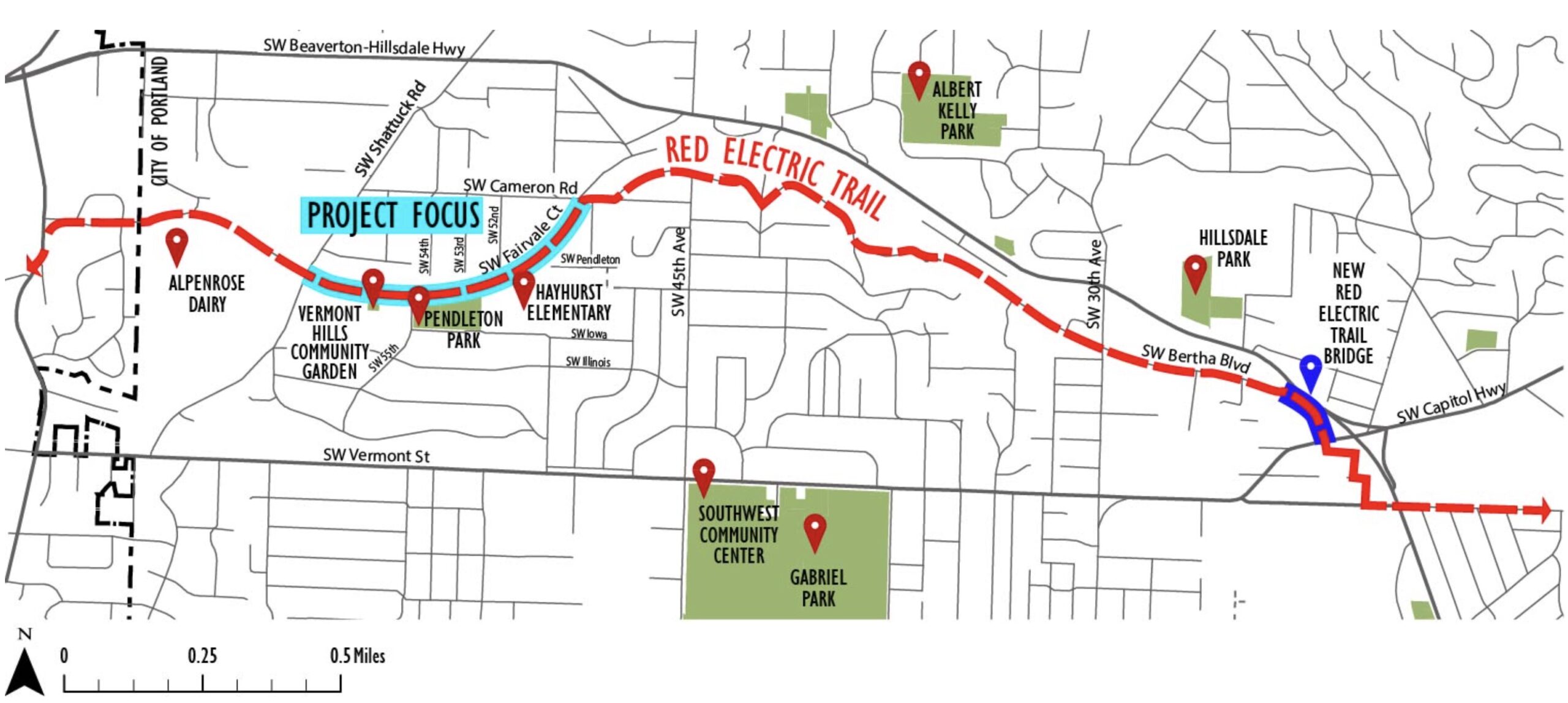
This segment will ultimately connect to the west with the portion of the Red Electric Trail that will be built as part of the new housing development at Alpenrose.
In the past year, the City has hired a design and outreach consulting firm. They’ve also had crews clear out vegetation on the trail and have completed initial survey work. Now they’re ready to share what they’ve learned with the public and hear what folks think about the project in general. An online survey opened this week and they’ll be at the Hayhurst Neighborhood Association meeting to make a presentation tonight. There will also be a neighborhood walk starting from Pendleton Park from 4:00 to 6:00 pm on June 20th.
When this project is completed by next summer, the City will have all the major design elements, a cost estimate, and a construction timeline nailed down. Stay tuned for chances to weigh in and check out the project website to learn more.


")

Thanks for reading.
BikePortland has served this community with independent community journalism since 2005. We rely on subscriptions from readers like you to survive. Your financial support is vital in keeping this valuable resource alive and well.
Please subscribe today to strengthen and expand our work.
Is there a reason this old interurban ROW isn’t being considered for a future rail line? Is the demand for the west side just not sufficient to justify the cost?
Quite frankly, yes, the cost would be too high for a low level of demand. I say this as someone who is pro transit, but trying to reactivate this rail line, that’s been abandoned and built over for close to 100 years, would be a waste of resources.
The Southwest Corridor would have recreated a portion of the line, but much of the rest (from Hillsdale to the edge of Beaverton) has been built up as low density, single family homes, with low connectivity. A high capacity transit line through SW could be useful, but this one would wouldn’t justify the cost.
Depends on what type of rail service the corridor was used for. I’ve always thought it might be worth it to rebuild one of the former ROWs as a proper intercity line again (though the Red Electric is not the most attractive option for that imo).
Light rail (in terms of how the FRA thinks about it) is a poor choice for SW Portland – unless we are going to be running the MAX to Salem. SW Portland’s primary strength from a rail service perspective is being strategically positioned on the shortest route (I5) between Portland and Salem. To best take advantage of that, it makes way more sense to think about a regional rail/intercity rail type of solution.
Although the most difficult part of this idea would almost certainly be figuring out what route to take between Downtown Portland and the start of Barbur. I’d say 4th for historically accuracy, but I don’t really think street-running mainline rail service is very attractive to the average person (even if I think it’s cool).
BRT with lane priority (a new FX line) on BHH would make more sense. Development has grown around that corridor, not along the old interurban ROW.
To clarify, before the vegetation clearing to do the survey work several months ago this ROW was impassable.
I’ve been walking it since 1999 with my dog. Overgrown but not impassable.
I tried walking it after it was cleared over the winter and it was so muddy! Didn’t know it was passable before then.
Have there been any discussions with THPRD in Washington County to extend or connect to this trail? The trestle that carried the Red Electric over Oleson Road and Fanno Creek is long gone.
It seems like THPRD has been concentrating on the Fanno Creek Trail that uses portions of the old Oregon Electric right of way, while Portland has been working on extending a path along the old Red Electric right of way.
THPRD (Tualatin Hills Park & Rec)
I think the plan is for the Red Electric to “connect” to Fanno Creek Trail by just following SW Oleson. See https://swtrails.org/trails/red-electric/. This is probably the biggest downside to this trail is the lack of westward connections. The options to continue going West of Oleson is BH Hwy (high speed stroad with no bike facilities), SW Vermont by the elementary school (ROW that the school keeps trying to close off), and Fanno Creek Trail (doesn’t really head into Beaverton).
I don’t believe the ROW even exists over Fanno Creek anymore.
In the long run I bet it goes through Bauman Park, to Jamieson, to 5th. That’s the east west corridor for bikes through Beaverton.
A straight connection to Jamieson would be the dream and could mean a less than 20 minute bike ride from Alpenrose into Beaverton.
It would removing lots of invasive scotch broom, making a boardwalk above the floodplain, and buying some additional land from a property on SW Willowmere Drive. That is the lowest cost because the alternatives would require more expensive bridges and purchase of land on SW Willowmere Drive / SW Dogwood Lane. THPRD already owns a slice of land on SW Willowmere Drive that was formerly owned by Portland’s BES sewer department.
Metro has a plan or drawings to make a new trail that will go from Oleson and then into Bauman Park and then over to nearby SW Willowmere Drive because Portland’s sewer department sold a slice of land adjacent to Fanno to THPRD. THPRD / Metro has a plan to make a trail essentially go from Montclair Elementary school and then through the property of both the private OES school and then through the private Portland Golf Club to get over to the Fanno Creek Trail. The trail on Vermont could get built in two months with volunteers.
Huh, didn’t know about that ROW but I found it on the map here https://www.thprd.org/parks-and-trails/detail/bauman-woods-natural-area
The very tricky thing is how to buy another slice of land at that southwest corner. It is where Vermont Creek meets Fanno Creek. The minor slice of property to the east of that slice on Willowmere won’t be easy.
Anything new on the Salmonberry trail? I remember hiking a part of it many years ago and came across an abandoned Willamette geared locomotive smothered in blackberry bushes and down trees. It has since disappeared. Wonder what happened to it?
yes there is some good progress to report on the Salmonberry.. I have just not been good about getting that story done. They just had a trail clearing even last weekend that I wanted to go to and report back. I will get an update done ASAP. Thanks for asking Mike.