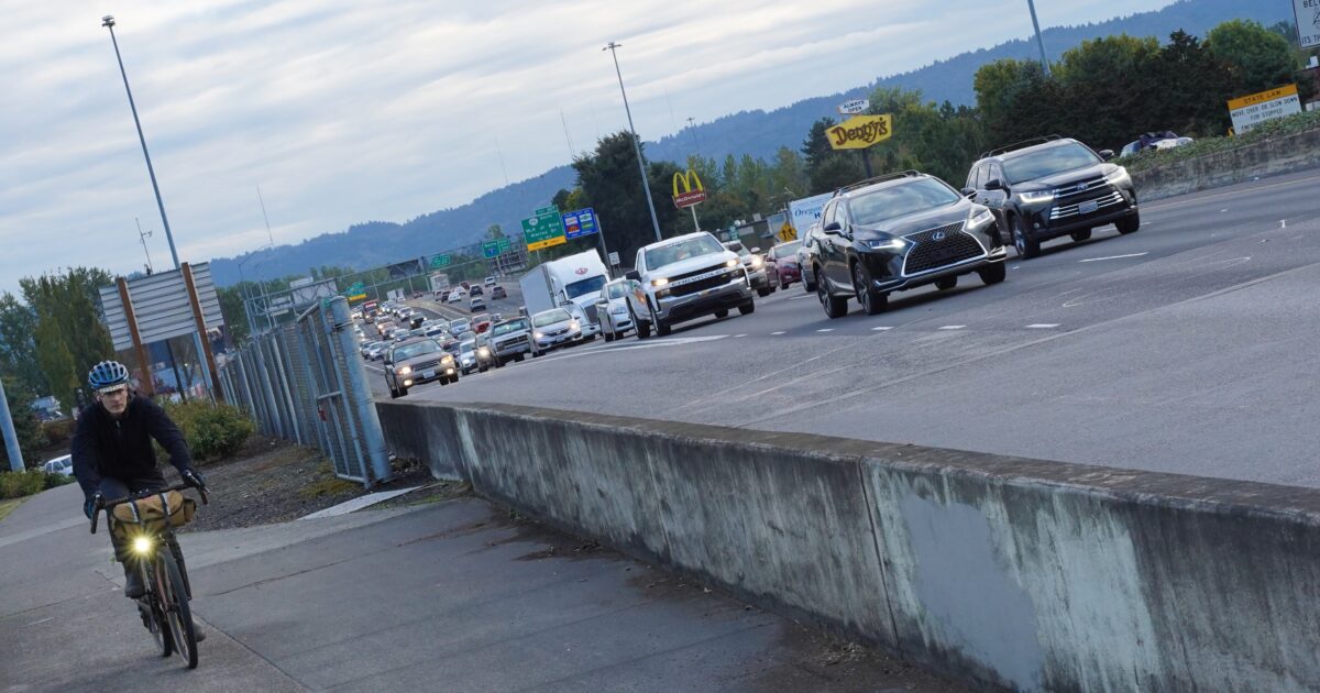
(Photo: Jonathan Maus/BikePortland)
“[The project] needs to demonstrate how it won’t contribute to elevated rates of asthma and hospitalization for Black and brown Portlander…”
— Jo Ann Hardesty, Portland city commissioner and Executive Steering Group member
After months of discussion about process and “vision and values”, the project team behind the second attempt to expand I-5 between Washington and Oregon finally presented a set of design options for the five mile highway project to elected leaders from around the region last week.
These were described by project administrator Greg Johnson as the “universe” of options that fit the purpose and need of the project, unchanged since the failed Columbia River Crossing project was given Federal approval in 2011. After all of the signs in the past year have been pointing toward just a recycled version of the CRC, it will surprise few readers here to learn that there are now just three options for the highway itself left in the “universe”, and they all have ten traffic lanes.
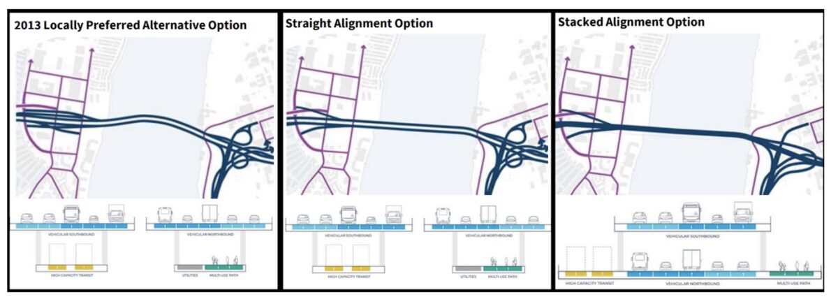
Two of the designs are identical in cross-section: the selected design from the CRC, with two bridges carrying five lanes each with space for transit on the lower level of one and a multi-use path on the lower level of the other. Another tweaked design straightens out the alignment, which would be “less complex” to construct, per project documents. And a third option stacks five highway lanes on top of the other five, with transit on one side and the multi-use path on the other. This design would “minimiz[e] impacts to the natural environment and surrounding areas”, according to the memo on the proposed designs.
Advertisement
Of course, the number of lanes shown is one thing. Project specs that leave room for additional lanes down the road are another, as City Observatory has repeatedly shown with both the Columbia River Crossing and ODOT’s related project in the Rose Quarter.
Ten options for public transit across the river were also outlined but given essentially zero scrutiny among the leaders. Those options include three Bus Rapid Transit (BRT), four light rail (LRT) options, and a bus on the shoulder of I-5. All those transit options as well as the multi-use path are being treated as the extent of the climate considerations between the highway design options. No matter the design of the highway, space for transit, walking, and rolling will “create appealing and effective transit and active transportation opportunities” leading to decreases in emissions, per project documents.
Advertisement
It’s not at all surprising that the narrow set of outcomes proposed now are nearly identical to what was developed ten years ago, given the fact that adding a climate lens directly to the project’s purpose and need, or using a broader definition of equity when it comes to project outcomes was discarded to keep the project on an accelerated timeline. The question is what happens next.
“What would it look like if there was a more robust transit, a more robust congestion pricing program, what does that do to demand?”
— Lynn Peterson, Metro president and Executive Steering Group member
During the meeting, there was some pushback on what the project team brought forward. Commissioner Jo Ann Hardesty, as she has at past Executive Steering Group meetings, signaled that what was being presented fell short, but not in a way that suggested that the very fast timeline to get the project designed should in any way be hindered. “My concern is that the design options for the bridge alignment and interchanges have been developed in a way that suggests that we already know what the solution is.” she told the group after signing off on the list of project outcomes that includes faster travel times on I-5.
Commissioner Hardesty was clearly not comfortable saying that the three options for the proposed highway were the entire “universe”. “[The final design] needs to demonstrate how it won’t contribute to more 124 degree days like we experienced just this last summer in the Lents neighborhood in Portland. It needs to demonstrate how it won’t contribute to elevated rates of asthma and hospitalization for Black and brown Portlanders, which normally are the recipients of the negative outcomes of freeway activity,” she told the group. “Are we really moving the project forward in a way where we can be confident that, in the design options we will explore, that we are addressing these very core issues?”
Metro President Lynn Peterson was the other voice in the room pushing back, explicitly asking for an additional highway design option to act as a “bookend”. She suggested that option should look at “what would it look like if there was a more robust transit, a more robust congestion pricing program, what does that do to demand, so that we can actually see how that works and what elements are playing with what?” Peterson said the assumptions on how pricing may impact demand for the highway seem “too muted” at this point. But Peterson referred to this as an “outer limit” design, suggesting that it would primarily be useful to the group as a comparison to the other proposed designs.
Peterson is having to navigate the fact that she’ll have to sell any outcome of consensus at the Executive committee back to the full Metro Council, which includes members who are skeptical of where the project is headed. (We’ll have more coverage on that side of the project soon.)
Last week’s meeting was also a test of the degree to which the community groups that the project team has created, the Community Advisory Group and the Equity Advisory Group, will be truly listened to in the process. Lynn Valenter, a co-chair of the Community Advisory Group, abstained from giving a yes or a no on the proposed design “universe” because the CAG or the EAG hadn’t even had the material presented to them yet. Those groups are a big part of the strategy in avoiding the outcome of ten years ago, but will their input meaningfully change the outcome?
This week, we’ll learn what Oregon and Washington legislators think about the “universe” of options as the project steams toward a final “IBR solution” by the end of March. By the end of the year, it will be pretty clear if this project will meaningfully change to reflect the reality of those 124 degree days that Commission Hardesty brought up, or if we’re still trapped in the CRC reality.
— Ryan Packer, @typewriteralley, ryan@theurbanist.org
— Get our headlines delivered to your inbox.
— Support this independent community media outlet with a one-time contribution or monthly subscription.



Thanks for reading.
BikePortland has served this community with independent community journalism since 2005. We rely on subscriptions from readers like you to survive. Your financial support is vital in keeping this valuable resource alive and well.
Please subscribe today to strengthen and expand our work.
Such restraint by the engineers. I fully expected a 20-26 lane proposal to get top billing.
Such a bridge would be cheaper than a light rail line
Citation needed.
$7-$20 million per lane mile, making the CRC $84-240 million per mile. A 20-lane freeway would be $140 to $400 per mile. Of course, we know that the highway elements of the CRC alone are $3+ billion (look up the breakdown in previous CRC documents).
https://www.strongtowns.org/journal/2020/1/27/how-much-does-a-mile-of-road-actually-cost
Orange Line was $200 million per mile:
https://www.bloomberg.com/news/articles/2018-01-26/the-u-s-gets-less-subway-for-its-money-than-its-peers
It’s not the engineers causing the need for lanes – it’s the land use planners and those seeking to accommodate expected population growth. Case in point: thousands of residences and thousands of new jobs planned for Hayden Island/Janzen Beach are what caused the need for the massive collection of ramps on Hayden Island with the original CRC project. If we decided to turn the entirety of Hayden Island into a wildlife refuge, we could eliminate ALL the ramps and the existing interchange.
We can’t just decide to turn Hayden island and Janzen beach into wildlife refuges. You’re talking about hundreds of acres of private property that has been developed, or which have entitled development rights. Unless the owners of those lots choose to turn their neighborhood into a nature preserve, the only way to create a wildlife refuge would be to use eminent domain and to compensate the property owners with the fair market value of their property (likely hundreds of millions of dollars, in total).
Was it a good idea to develop Hayden island in the first place? Probably not. But it was first developed over 100 years ago, and property rights dictate that it isn’t going away now.
That’s exactly why the original CRC plan provided for a complex system of ramps for Hayden Island – to serve the uses planned for Hayden Island. It’s unfair to blame the engineers for the design of the highway and the ramps that made such a large footprint in the original CRC design. Those who hate the CRC project and the new version haven’t come to grips with or explained how to undo the land use plans that lead to a big, expensive, and complex project.
The interchange with Hayden island is only a small part of the problem. It’s also the ten plus lanes of vehicle SOV traffic.
I’d solve the problem by disconnecting Hayden island from the freeway completely. Just create a separate bridge to get people from Marine drive to Hayden island that completely avoids I5
The place I grew up got turned in to a wildlife refuge, so it can be done. When I was a kid there was a big wooden roller coaster on Hayden Island. It has been downhill ever since.
If they keep a lift span, the impacts of the ramps could be much smaller. If they limit the highway to 3 lanes/direction, the project would far less impactful. The ramps could be eliminated by providing a local bridge to the island that could be paired with a lightrail bridge. This would provide a meaningful transit and bike/ped connection between Portland-Hayden Island-Vancouver.
We have better things to spend out money on. Don’t build it.
If a new bridge does gets built, it should ONLY be built with the same number of lanes. It also should not include expanding lanes on either side of the bridge either.
And it would have to include MAX extension, and it would have to include much better walking/ biking lanes.
Transportation policy should not be based on spite for motorists
Transportation policy should also not be based on paving over the whole world to only serve drivers.
10 lanes on one bridge is not paving the whole world
It’s not spite, it’s opposition to spending policies that directly contradict and have the potential to damage regional planning priorities. Building new freeway lanes will encourage more sprawl, leading to more vmt and more transportation and consumption related carbon emissions. We should not be spending billions of dollars to turn the Portland metro region into a cheap knockoff of Houston, Texas.
Houston is a far more equitable and livable metro area. They have much cheaper housing.
You are giving the game away, this is all about restricting our mobility and putting planners in charge of our way of life.
“livable” is subjective. Have you ever been to Houston?
No, but I know that it’s got very cheap housing, relatively little traffic for a city its size, and is far more diverse than Portland. I have been to Phoenix and I found a city that has largely paved its way out of congestion and where every vacant lot has a Toll Brothers sign on it
I’ve been to Houston several times. The congestion is unbelievable. It’s also a really flat and boggy city that sprawls forever in every direction. The highest part of the city is where I-10 crosses the Sam Houston tollway.
Much of Houston does “form planning” rather than land use planning whereby a certain use density is allowed but the land use is not predetermined. The intensity of the use density is determined by what the land will support, water use & drainage, and delivery of services. If a developer builds lots of housing but it doesn’t sell, they can tear everything down and start over, or even in parts and have mixed uses, all without dealing with zoning. It’s a bit more organic that way.
The area has lots of stroads and boulevards that are just wide enough for two car lanes in each direction, but not for bike lanes. Sidewalks are not universal.
I love how comfortable you all feel with just making stuff up to fit your narrative.
Houston drivers stuck with one of the worst commute times in the country
“In the Houston-The Woodlands-Sugar Land metro area, drivers spend 29.5 minutes a day on one-way trips and 59 minutes on round trips, the report says. Researchers project Houstonians will spend almost 10 full days (9.95) commuting this year. Meanwhile, the average American will spend only 7.4 days making the same trips.”
https://houston.culturemap.com/news/city-life/03-04-19-houston-worst-traffic-commute-times-america/
Portland is only 26 minute average commute btw
Of course, anyone who looks at Phoenix and thinks “they’ve done a good job here’ has to be a little bit it out of it.
I’ve been to Phoenix and found a city that paved itself into a hellhole. I haven’t been to another city I want to visit again less, and it’s largely due to the built environment. At the time, I’m pretty sure it was #1 for pedestrian fatalities in the country, too.
^
damiene
You should check out Houston.
It’s going to be planners making decisions under the direction of elected officials regardless of what is done. Either it’s highway engineers at the state dots working under the direction of the state government with the blessing of federal transportation planners, or it’s local and regional planners working for local and regional governments. Don’t pretend that highways just grow organically without any forethought or government decision making. You’re just bandying about some silly notion from conservative politics that all things that are favored by liberals is this evil ‘planning’and that all things that are done at the behest of industry lobbyists is somehow the opposite, and therefore not ‘planning.’ Give me a break.
A highway engineer would look at the massive traffic jams on the Columbia River Crossing, then conclude there is an unmet demand for travel and then plan to add more capacity to meet that demand.
An urban planner would say all the people trying to cross the bridge are stupid and then plot all sorts of rube goldberg schemes to get them to stop crossing the bridge
Civil engineering vs Social engineering
A smart engineer would look at that demand and think of ways to increase throughput without needing to add any space.
Spoiler alert: That means less cars.
Please tell all of us how you would increase throughput of a lane. Smart engineers have dedicated their careers to trying to achieve that.
Please note: “less cars” is not increasing throughput; it’s reducing demand. Econ 101 covers supply and demand.
https://nacto.org/publication/transit-street-design-guide/introduction/why/designing-move-people/
Smart engineers have already figured it out. What’s left is a political problem, not an engineering one.
You’re conflating cars with demand – less cars does not mean less goods or people (the actual demand). Quite the opposite, as the NACTO link explains.
Exactly, it’s not an engineering problem; it’s a policy problem. Specifically, the policy makers enact policies that increase demand (tax policies, incentives to use fossil fuels, etc). Policy makers do not give highway engineers the authority to implement demand management strategies or give them the power to change the financial structure to substitute the use of one mode for another. People make their selection of mode for travel on a variety of factors and the engineer has no influence on most.
When you have neighborhoods and transport systems that were designed in a way that they couldn’t be navigated unless every single resident owned cars, it’s no wonder there is demand for more and more roads. The congestion didn’t arise organically, it was the result of zoning and planning decisions that were made over the last eighty years. American car dependant suburbs ARE the very epitome of social engineering.
You want to talk about a Rube Goldberg scheme? That’s the SOV transportation system in a nutshell. Mass transit moves more people faster while occupying less space and consuming fewer resources (and it does it at a much lower expense when you factor in the cost of car ownership and vehicle storage areas). Putting every single person in their own private box with their own private motor adds infinitely more complexity to the transportation system.
Infrastructure shapes behavior Therefore road or bridge building is social engineering.
Generally, cheaper housing means less livable, not more. If housing is more expensive, that means people are willing to pay more to live there. Usually this is because it is considered a better place to live, i.e., more livable.
Portland has tried for decades to make driving so miserable people would get out of their cars. It hasn’t worked.
To Ms Hardesty: a better response to heatwaves is getting more people air conditioning than making traffic worse for hundreds of thousands of commuters. And does she think white children don’t get asthma or does she not care?
Advocating for AC units as a response to catastrophic and extreme heatwaves caused by anthropogenic climate change shows an amazing lack of knowledge on the situation, congratulations!
Is this the ‘all lives matter’ of transportation planning? I think it is. Policy is hard to understand, kernals12, when you don’t have any understanding of history. I’d start there rather than expecting Hardesty to contextualize a statement on a well documented and known problem for people who haven’t done the work.
If you think driving in Portland is miserable then you have never driven in Houston, LA, DFW, DC, or NY/NJ. Driving anywhere in the world during rush hour is always going to be relatively miserable to doing pretty much anything else.
Some would say: what is “10 lanes among friends?”…a Biden compromise of sorts that gets tolling + high capacity transit + ‘world class’ bike and ped crossing built…a package needs to build deep support among both Clark County + Washington County + Clackamas ex-urban areas with Portland + Vancouver’s urban core areas…otherwise we will see the muddle we all lived (and worked) in 10 years ago.
The other thing to consider is a complete IBR project failure or reducing the number lanes further down “may” create an additional future scenario – little discussed – that drives political pressure to build “The Third Bridge”…a facility that has been trumpeted by many ex-urban Republican/ Trump leaning types back pre2010. Such would open up Oregon & Washington state rural/ Gorge areas to a 1990s sprawl that east I-205 metro areas now lives with…all those subdivisions and corporate HQs (HP, Banfield, Nautilus, etc.) were recently timber and ag in our lifetime. Plus I doubt a Third Bridge would have real high capacity transit in a dedicated lane.
Remember my friends, Montavilla once was Portland’s gateway to rural eastern MT Hood areas… just saying.
Looking at how the ‘Biden, compromise is going at the federal level, I think we would most likely end up with ten vehicle lanes, and no transit or ped/bike facilities.
I have a list of things people like to talk about but will never happen:
Flying cars for the masses
Self driving cars for the masses
Peace on Earth
A new bridge over the Columbia
If we had flying cars, why would we need a new bridge over the Columbia lol
I live on Hayden Island so I follow Interstate Bridge Replacement closely. I live in a mobile home park (450+ units) on the Island. Like Robert Moses, nobody at IBR seems concerned about us. We are their target.
One problem IBR DOESN’T address is congestion. Another problem is bike access. Their proposed bridge is twice as high. How will that work for bike access?
I have an alternative plan:
https://www.facebook.com/sam.churchill
1. Replace the current I-5 bridge with a new bascule-style draw bridge ($1.2B).
2. The bridge has bike lanes as well as two lanes for small, rubber tired autonomous shuttles. No Max.
3. Build a tunnel entrance ($800M) for the EV shuttles near Expo Center. They can travel straight to downtown in 12 minutes. NO STOPPING at 12 stations (like Max) or waiting in I-5 traffic (like BRT). Put your bike on PERT (Personal Electric Rapid Transit).
This plan would probably cost less than $2B. Half the cost of the IBR. Catch a 12 minute shuttle direct to downtown Portland for $5, one-way. Connect with other autonomous shuttles in Portland and Vancouver. Travel directly to your destination.
And it addresses the elephant in the room…I-5 congestion.
Will ODOT and WSDOT study the viability of alternative views to IBR?
NOT A CHANCE.
https://www.facebook.com/sam.churchill/posts/10161165329773219
https://www.facebook.com/sam.churchill/posts/10161163725473219
https://www.facebook.com/sam.churchill/posts/10161160007923219
https://www.facebook.com/sam.churchill/posts/10161162263168219
https://www.facebook.com/sam.churchill/posts/10161141122783219
Sam – you are correct to point out the ‘impact’ of past height design of the CRC bridge on bike access…few folks in the general public ever knew until the end of the process how tall it was going to be…something like the deck was going to be higher than the top of the 1917 bridge arches….as river clearance access pushed it to up to ~125 feet.
https://www.columbian.com/news/2012/nov/08/crc-125-foot-bridge-height-problematic/
At least we have the LRT engineering to help limit the grade of the bridge approaches…MAX trains cannot climb up too steep of a slope in poor weather…in general rail grade is bike friendly grades…but its going to be a very long ramp…
It will never be built. Republicans will most likely retake Congress and the White House and they have no interest in funding infrastructure.
The Big One is already 21 years overdue, and with earthquakes and volcanic activity on the rise worldwide, well…
Climate change and disease will continue to take a heavy toll on human overpopulation.
You forgot nuclear war and the A.I. Metaverse takeover. Soon the Bicycling Dead will eat our brains.
“21 years overdue” is just not how it works.
I believe the main motivation behind the Rose Quarter expansion is to set the table for a larger project here.
(I made this comment earlier… was it embargoed for some reason?)
The I-5 Trade Corridor Study produced in 1999 identified three problems: the I-5 bridge; the two lane section of I-5 southbound adjacent to Delta Park (since widened); and the Rose Quarter. That was over 30 years ago. The Rose Quarter project was not recently invented to “set the table” for replacing and expanding the I-5 bridge.
One of the big arguments for a smaller CRC was the constriction at the Rose Quarter. The current highway configuration makes the 10 lane profile seem a bit excessive.
If the constriction is gone, the larger profile makes more sense.
I-5 where it passes under the Fremont Bridge (north of the RQ) is two through lanes. That is not changing with the I-5 RQ auxiliary lane project. Widening through that section would be incredibly expensive due to the Fremont Bridge approach supports. It is not a project on the table.
I don’t get it. Why 10 lanes through this section? I-5 along the Minnesota Ave trench is pretty much restricted to 6 through lanes. Maybe you could restripe to allow for 8 through lanes, but it’s highly unlikely there would ever be the political will to widen the trench to allow for 10, let alone 12 lanes. So if you’re driving from Vancouver across the CRC, you’ll always be forced to go from 5 south bound lanes to 3, or really 2 if you’re a lone driver and can’t use the HOV lanes. How will this not increase episodes of congestion on I-5 south bound through the trench? Then presumably many of those drivers heading south will head back north later in the day right back through the trench.
You see a bottleneck, ODOT and their contractors see another juicy project.
Three thru lanes. Two additional lanes that go to specific on/off ramps.
Yep. Those are the ramps that will funnel massive amounts of Washington commuters into North and NE Portland neighborhoods. The CRC is going to be a disaster for active transportation in N/NE Portland.
In theory it will be people already working in that part of town that are already driving there. Though, if the congestion pricing isn’t done right then you risk people taking city streets instead of the freeway.
The issue is that you have 5 lanes over the bridge, 2 of those lanes exit shortly after, and you hit 3 lanes at Hayden Meadow. Those 3 lanes will be the new choke point. If the backup gets bad enough, Google/Waze will start telling people to exit at Marine Drive or Hayden Meadow and take Interstate/MLK/etc to reach their destination, even if that destination is downtown or even points south of Portland.
The current CRC itself is the bottleneck, so these diversions are less common. Widening the bridge to 10 lanes opens the spigot.
Very thankful for Ryan Packer & Hardesty continuing to advocate for infrastructure that aligns with our goals. It’s a great time to contribute to Hardesty’s reelection campaign.
https://www.joannforportland.com/
Why? Because she expressed a degree of skepticism about this project? She isn’t even firmly against the Ride Quarter project.
Besides, I doubt it will help. Unless she has a totally inept challenger, I can’t see how she could possibly win. The next election will not be kind to politicians who have built such a strong anti-police brand.
You should get off facebook and talk to people who actually live in Portland. It looks like conservatives are going to align behind a ‘back the blue’ type and Hardesty is going to roll them.
She is popular among real people, not so much on /r/portland and online comment sections.
That’s very de-humanizing language.
Maybe you have a point — most of the people I talk to are in that ultra-conservative enclave known as inner SE Portland. Everyone, and I mean to a person, that I have any regular contact with is profoundly unhappy with how things are going, and want change. Most of them supported Hardesty last time around, and I can’t imagine any of them will do so again (barring an incompetent challenger). It doesn’t take that many people thinking the same way to change a 61% victory to a 49% loss, and it surprises me to hear that folks are still happy with her in St Johns at a time when no one is really happy with anyone.
I like a lot of things about Hardesty, but her timing was really unfortunate.
Yeah, you’re a conservative guy, you’re going to tend to talk to other conservatives. I’m also unhappy about what’s going on, but to me that means booting off the conservatives like Wheeler and Ryan and Mapps. I wouldn’t say I like Hardesty really but she’s easily the most educated and competent elected on there, which isn’t saying much.
Hardesty is easily the most popular one. Inner SE is neo-liberal yuppies so it wouldn’t surprise me if they were buying the ‘law and order’ nonsense that PPB is selling.
She’ll do poorly Irvington and the Pearl and do excellent in east County and on the peninsula and cruise to her next term. Hell, I bet she wins Buckman and surrounding areas.
And Ill say for Hardesty, she is the only one at the city that has shown even a modicum of real concern for east Portland or generally neighborhoods outside the west hills and central city and people love her for that. I seriously doubt a central city ‘back the blue’ type is going to sway folks. I don’t think PPBs work slowdown and ‘Do you Feel Safe Portland’ threats are working in the way they intended so people generally still agree with her PPB divestment message.
Anyone who calls me a conservative may be confusing rationalism with policy preferences; most of mine are as far to the left as you can go before ideology supplants effectiveness or fundamental liberal values.
Regardless, I think Wheeler and Ryan are extremely vulnerable as well; despite their lack of as much anti-police baggage, they too are seen as part of the inept leadership that is a big part of the problem. Wheeler owes his re-election to electoral dynamics, not popularity.
I don’t think people want a “back the blue” candidate as much as they want someone who can be effective. Anyone who can convince voters that they can make a visible difference in the mess that Portland has become will have an easy path to victory, regardless of their politics.
Hardesty and Wheeler are probably more closely tied to a general sense of failure than anyone else. Wheeler at least has a couple of more years to show he’s making progress, but Hardesty doesn’t have that luxury.
The CoP is designed to maximize grift. No one is going to be ‘effective’ really, at least not like folks would like to see. There are so many entrenched bureaucratic fiefdoms within the CoP. Add on to that bureaus know that commissioners get changed all the time so its frequently a waiting game, and you have yourself a major problem.
The folks I know who have worked at CoP have not had nice things to say about it.
Right, and Hardesty is very good at that and folks are really receptive to what she’s saying.
You’re reaaallllyyy misunderstanding how Hardesty is received in Portland generally. She’s easily the most popular, visible commissioner.
Wheeler is in the most danger. People, especially in working-class Portland hate him. Some hate him for his actions, some hate him for his inactions, but I’ve never met anyone personally who liked him. I think I saw one Wheeler sign in my neigborhood last go-round.
I think Ryan and Mapps benefit from having done nothing that the public will notice. The reality that Ryan has been working on finding camp locations for over a year now and only found two should be enough to get him sacked but who knows.
Convincing people desperate for a shred of hope that you can be effective is different than actually being effective once you are in office, so even if you are right that Portland government makes doing a good job impossible (an assertion I do not accept but we don’t need to debate here), it doesn’t matter to my analysis.
As for grift? Portland politics is pretty clean as far as politics goes. Having seen “real” politics, it is annoying when people suggest Portland is corrupt. It isn’t.
Regardless, I agree about Wheeler — you saw one more sign than I did. The election wasn’t about him. He was left standing more than he won. Things may look different next time he’s on the ballot.
Ryan has until voting starts to find those sites and get them up and running and find a way to deflect blame for the delay, but even then they will be collectively too small to make much difference (except perhaps to those lucky enough to score a spot). It does not look promising.
We’ll find out soon enough whether you’re right about Hardesty. I think it entirely depends on who challenges her. Maybe she’ll get lucky the way Wheeler did.
The mayor gets to literally hand out better Bureau assignments based on a patronage system. Corruption is baked into our basic form of government.
I don’t think she’ll need luck. I think there is going to be a lot of deflated conservatives on election day when she clear 65% of the vote and sweeps most of Portland east of the river.
It’s not just this project, it’s her consistent advocacy for public & active transportation modes. I don’t think any other city council member is as committed to holding ODOT to account as she is, particularly w/r/t congestion pricing vs. tolling, which I consider to be important. She drives the least out of any city council member (or local politician that I know of) and it shows, imo.
This is the same city counselor that runs PBOT but didn’t know that PBOT has a Bike Plan?
https://bikeportland.org/2021/05/12/pbot-commissioner-has-revealing-heated-exchanges-with-bicycle-advisory-committee-members-331135
To my mind that’s on PBOT, not commissioner Hardesty.
Hardesty’s known about the Bike Plan for 6 months; I imagine she’ll start championing it any day now.
Thank you Ryan for this important and informative article! Can you share a link about upcoming meetings that are open to the public? I’d like to attend some to share my disapproval of this project.