The Portland Police Bureau just reported a fatal collision involving a bicycle rider in north Portland.
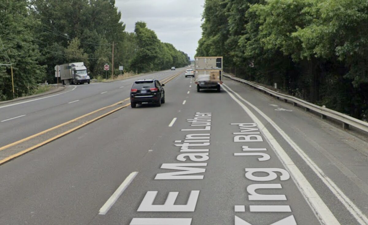
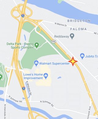
According to the PPB statement, the collision happened around 4:45 pm this afternoon (Friday, 12/4) near the intersection of North Union Court and Martin Luther King Junior Blvd. The bureau’s Major Crash Team has started an investigation and no other details have been released at this time (see update below).
Union Court is the small road that connects to Marine Drive at its northern end and runs along the eastern edge of Delta Park. It connects to the Hayden Meadows shopping center and it’s one-way southbound where it merges with MLK (OR State Hwy 99E). Less than a month ago, 18-year-old Obduwier Romero-Moreno died when he lost control of his car while driving on MLK less than a half-mile south of this location.
Advertisement
This is the 51st person to die while using Portland roads in 2020, making it the deadliest since 1996. There have been five bicycle riders killed this year, the most we’ve had since 2016. This is only the fifth time since 1996 that Portland has recorded five or more bicycle fatalities. I’ll update this post when I have more information. If anyone saw what happened, please drop me a line.
UPDATE, 12/5 at 9:31 am: PPB have released more details (emphases mine):
Based on both the driver’s and witnesses’ statements, the vehicle was travelling northbound on North Martin Luther King Junior Boulevard in the left of two lanes. The driver said they observed a bicyclist in the right shoulder bike lane ahead of them as they were traveling northbound. The driver noted the bicyclist was slightly weaving in their own bike lane. The driver said the bicyclist, without warning, abruptly maneuvered their bicycle left and into the two lanes of northbound travel. It appeared as though perhaps the bicyclist was maneuvering towards a ramp on the opposite side of the road in the southbound lanes which comes from the Delta Park area. As the bicyclist crossed into the left of two northbound lanes of travel, they were struck by the driver and came to rest in the roadway just in front of the vehicle.
Impairment and/or Distracted Driving on the part of the driver do not appear to be factors to this crash. The unanticipated lane intrusion appears to be the initiating factor for this crash.
The bicyclist who passed away in this crash has been identified as 64-year-old Gene Arthur Courtney. Mr. Courtney’s next of kin has been notified.
The posted speed limit at this location is 55 mph.
— Jonathan Maus: (503) 706-8804, @jonathan_maus on Twitter and jonathan@bikeportland.org
— Get our headlines delivered to your inbox.
— Support this independent community media outlet with a one-time contribution or monthly subscription.


Thanks for reading.
BikePortland has served this community with independent community journalism since 2005. We rely on subscriptions from readers like you to survive. Your financial support is vital in keeping this valuable resource alive and well.
Please subscribe today to strengthen and expand our work.
Thank you for this writeup based on what you have been able to learn, Jonathan. Unfortunately, it will be a year or two or more before more complete information is likely to be available thorugh official channels. I expect the only more detailed reporting will be what you do.
In the meantime, people trying to learn about the area where the crash occurred yesterday may benefit from knowing something about a previous crash here.
This same location is where Justen Ashworth-Fivecoats was driving a 2002 Dodge Durango SUV northbound when he struck and killed Toby Holtrop at approx. 4:45pm on 5/12/17. Mr. Holtrop was reportedly walking with hand cart(s) across MLK from east to west.
THE AREA
This area has a mix of uses, including the Fox Run neighborhood, industrial and retail employers and services, camps, dispersed transit stops, the race track, and other entertainment. Bikes, carts etc are extremely useful in this neighborhood given the relatively long distances a variety of people have to cover to access a variety of destinations.
NE MLK
This is an approx. 2-mile stretch of MLK that ODOT operates as an urban highway. It “drives like a freeway,” but lacks many of the engineered safety features such as access control, a center jersey barrier to prevent crossover crashes, and lighting.
CROSSINGS
There are no marked, signalized or improved crossings for approximately two miles on this stretch of MLK. The nearest crossings serving people using mobility devices or bikes or on foot are approx 0.7 miles to the north and 1.1 miles to the south. MLK is a north-south barrier for non-motorized modes. The nearest underpass is at NE Walker St, 1,500′ to the south, however its bike lane and sidewalk dead-end into the footing of the underpass:
https://www.google.com/maps/@45.5928004,-122.6672763,3a,75y,258.23h,79.48t/data=!3m7!1e1!3m5!1s9L0TqsbhxX3gz-3G0lxVbg!2e0!6s%2F%2Fgeo3.ggpht.com%2Fcbk%3Fpanoid%3D9L0TqsbhxX3gz-3G0lxVbg%26output%3Dthumbnail%26cb_client%3Dmaps_sv.tactile.gps%26thumb%3D2%26w%3D203%26h%3D100%26yaw%3D127.32435%26pitch%3D0%26thumbfov%3D100!7i16384!8i8192
(Note: This is much like the configuration where Martin Greenough was killed on NE Lombard at 42nd.) 3,500′ to the north, there is an underpass at NE Marine Way, which has bike lanes but no sidewalk connectivity.
There are several reasons people may cross MLK near Union Ct. despite (or because) of the dangerous design:
Most of this stretch of MLK has a median consisting of a raised curb (narrower than refuge island width). The raised curb is absent for a short stretch near the intersection:
https://www.google.com/maps/@45.5961935,-122.6702794,3a,75y,278.26h,79.51t/data=!3m6!1e1!3m4!1sLebGEfh8Ynz8z2ngvCd8_w!2e0!7i16384!8i8192
People with wheeled conveyances such as carts, wheelchairs, or bikes presumably will cross there if they can’t get up, over and down the curbed median.
The stretch with no curbed median is not aligned with what police would generally consider a legal unmarked crosswalk location (regardless of which spot is marginally more or less dangerous to cross). This means that a crash injuring or killing a person on foot or using a mobility device here will be coded as a pedestrian crossing outside a legal crossing. Such crashes are unlikely to gain the attention of any engineer.
As the police report from the 2017 crash indicates: “Transient camps are known by the police to be in the area.” Crossing MLK at some point is the only way for anyone living in the area (housed or not) to go east-west.
As for yesterday’s crash, it is too soon to know the circumstances. However, the lack of crossings, the effect of the curbed median, and the missing infrastructure that causes people to resort to “self-help” are the sorts of things that might well be overlooked.
SPEED
MLK here is posted at 55 MPH. There is not a speed study nearby. However, the wide lanes, long straightaway, lack of calming, and lack of enforcement/cameras appear to enable/encourage much faster speeds. For example, after the crash in which Mr. Fivecoats struck and killed Mr. Holtrop, the officer noted: “The minimum speed of the Dodge Durango when it began to skid was calculated to be 70.85 MPH.”
LIGHTING
There are no street lights.
POLICE AND MEDIA RESPONSE
Police, as is typical, focused on whether either of the roadway users involved in the crash committed a prosecutable offense.
KXL reported: “Police say 49-year-old Toby Holtrop was homeless. He was hit by 27-year-old Justen Ashworth Fivecoats, who was driving northbound on MLK. Holtrop was pushing a trailer full of empty cans and pulling a cart with other items when he was struck. The driver stayed at the scene and cooperated with officers. Ashworth Fivecoats has not been charged with anything at this time.”
TRANSPORTATION AGENCY RESPONSE
I’m not aware of any. If that’s not correct please somebody let me know. I wouldn’t expect any. PBOT and ODOT seem to do something (or not) based on what they learn from police responders who, in most cases, focus on whether a roadway user committed a crime. Secondarily they might or might not note other crash factors. A report that sounds like “homeless guy walks in front of a car” isn’t likely to trigger the informal processes by which agencies determine what, if anything, needs to be done on their part. There were some efforts in Portland to change that. After some VZ pronouncements a few years ago saying that PBOT would participate in immediate crash response, city records indicate as of Oct 2017:
“It has been agreed upon by PPB and PBOT staff that having PBOT respond immediately to crash scenes is not beneficial to PBOT staff. PBOT is better served responding to the scene once the [police] investigators have had time to identify the contributing factors to the crash, as oftentimes road design is not a factor.”
The other way safety fixes happen tends to be based on hotspots that show up in macroscopic data over multiple years. That data is rarely dense enough to identify ped/bike safety problems.
Police report:
https://www.dropbox.com/s/yxpviz0hlt67e9s/05%2012%202107%20N%20MLK%20AND%20UNION%20CT%20GO42_2017-146244.pdf?dl=0
A note about this post: If there was any ODOT or PBOT response to the crash that killed Mr. Holtrop (or any safety improvements at this location), or if you have information to suggest my understanding of that crash is inaccurate, someone please let me know. If you or your friends or family were personally affected by the crash described here and wish to add to what is written about it, or correct errors, or request removal of the information for any reason please likewise let me know. It is difficult to write about crashes in a way that fully acknowledges that they are personal and family tragedies, and at the same time a public health crisis that needs to be fixed at the community level.
Wow – what a write-up. Seems like our transportation agencies should report this level of detail, but I guess they don’t.
What stood out for me: There are no crosswalks for TWO MILES. Wow.
Thanks Fred. This 2017 crash really makes me realize how people experiencing homelessness are “invisible” to the systems that are supposed to provide transportation safety. Another thing I’m floored about on MLK is the no street lighting. Zero. There are engineering standards for that.
Evaluating how a street works often leaves a lot of really important things out. Your example is a good one. I see plans for a new street layout and have to come to the conclusion the engineer involved has never been there. But these engineers are also constrained by a lot of political decisions as well as design standards that place cars, not safety, as default. Sneckdowns give a great glimpse into what space people in cars actually use, and how flawed our designs are. One of my dreams is to insert a “percentage of reality” into street designs. For example, how many cars are parked illegally and where?, how many people are running lights or speeding?, if there is no safe infrastructure, how many people are riding bikes on the sidewalk or median?, if there are no crossings, how many people are attempting to cross and how often? When DOTs present a design all of these things should be transposed onto their sterile, perfect environments, prior to public input, to make it glaringly obvious the human impact these will have. We become shocked when these deadly designs impact people’s lives, but they are inherently unsafe and result in predictable outcomes that are baked in from the outset.
There are illegally parked vehicles all over Portland. The current pile of garbage around the east side of the Hawthorne Bridge now includes at least two RV’S AND SOME SORT OF TRAILER. This garbage is not safe and certainly impacts the livability of “our” joke of a city. Maybe this zone is not a smart place to cross. I have ridden in that zone hundreds of times with zero issue.
Transient camps encroaching into bike lanes, their detritus in bike lanes and sidewalk ADA violation caused by them, or rather the City of Portland’s willful failure to address conditions that unduly burden the disabled are getting out of control.
Utilizing engineering controls is frowned upon in a way, because its bad for homeless services enterprises’ business. Consider the vast grassy area by Little Caesar’s on Lombard just to the east of I-5 right by the off-ramp. There’s even a drive way and it is very clear that vagrancy related vehicles are coming and going. A simple, inexpensive engineering solution like erecting vehicle denial bollard can reduce the tents and other large objects and help prevent the growth of vagrant activity by an order of magnitude. Instead, they just spend money cleaning it over and over as it is more profitable for homelessness tailored businesses.
Many people confuse what constitutes a crosswalk. Mr. Kocher accurately describes the situational details you have misstated. Most crosswalks are not marked and there are several unmarked crosswalks along the corridor. I count eight intersections in the under 2 miles from Marine Way to Columbia, not counting underpasses. Every intersection has legal crosswalks (2 each intersection crossing MLK) and I doubt any of them are signed as closed, which is the only legal method to close a crosswalk.
Your comment seems technically correct, but misses the mark.
I see intersections (going N to S) at N. Gertz, NE Argyle, NE Halleck and NE Kilpatrick between N Marine Dr. and NE Columbia Blvd, plus some additional places like N. Union Ct. that have streets entering MLK from one side only. I may have missed some, so assume your “eight” is correct.
But first, Halleck, Argyle and Kilpatrick are at the extreme south end, south of the slough, so barely more convenient than going all the way to Columbia Blvd.
Second, most if not all of these are barely identifiable to drivers on MLK as intersections. They don’t even have breaks in the raised median to give a clue. Some don’t even have street signs. They look like driveways. This one at Halleck is typical:
https://www.google.com/maps/@45.5824509,-122.6617617,3a,75y,336.94h,103.52t/data=!3m6!1e1!3m4!1sS-g6JljZGodbAm8Cly8GLQ!2e0!7i16384!8i8192
Third, and most importantly, how do you cross safely at an unmarked, unsignaled intersection when traffic is going 55 MPH or more? If you don’t step out from the curb, nobody will stop. If you do, to give vehicles a chance to stop, they’ll be so far away from you that they may not even see you. And if you go into traffic and they don’t yield, you’ll be dead. To cross four lanes without relying on vehicles to stop, you need a gap in traffic of several hundred yards. If you misjudge, you get stranded on a narrow median with trucks passing you going 55 two feet from each side of your body. Even trying a sting operation would be potentially deadly.
So the existence of those unmarked crosswalks is basically irrelevant.
When I mentioned all the dangers of crossing at an unmarked crossing at an intersection that isn’t identifiable as one by trucks going 55-75 MPH, I forgot to add that you’d also be doing it at night on an unlit road.
It’s true there are no crosswalks, but there are two underpasses crossing MLK so you can safely cross MLK by using them. It’s faster to take chances crossing MLK dodging cars. Tons of people ride their bikes in this neighborhood against traffic for reasons I do not understand and go the wrong way on one ways. Hate to say it but I believe the account of the person driving the car. The chances of someone on a bicycle riding that recklessly around this area are very good, never mind the carelessness that I have mentioned.
Are they lying, or stupid?
I saw a quote once that people don’t realize how much their comments say about themselves. If those are the only two possibilities you can retort with it’s saddening.
“There are no marked, signalized or improved crossings for approximately two miles on this stretch of MLK.”
Crazy. There was a great article several months ago mentioned on a Monday Roundup that discussed people crossing illegally and getting hit, and how the response is often to block the crossing with railings and signs. It argued that the better alternative was to try to understand why people are crossing there (almost always because they need to cross, and there are no crosswalks anywhere near) and then give them a safe crossing. It’s similar to the idea of seeing where the lawns are worn between buildings on campuses, and providing walkways there, since people are showing that’s where they want to walk.
A year or two ago, I remember reading about a woman in Hillsboro (or somewhere out west) being killed crossing a highway, where there was no crossing within a couple miles. She was also just another person crossing illegally as far as any accident report would go.
It really is important to ask WHY people are crossing where it isn’t safe, and then do something to remove that need, rather than just use the fact that they did that to close a file.
If crossing demand comes primarily from transient camps, it might be more effective to relocate those camps to reduce crossing demand, rather than try to create a safeish at-grade crossing, which would likely be very expensive (involving a signal of one sort or another).
Yes.
There are probably hundreds of homeless people in this neighborhood and on NE 33rd on the Marine Drive end. If you think there are a lot of homeless people in other parts of the city trust me it does not compare.
The I-405 area in downtown/NW has some of the sketchiest people involved in plenty of bike choppery and drugs.
I’m very sad to hear of this. Thanks for reporting. My heartfelt condolences to the family.
This is yet another failure of the city of Portland to protect its most vulnerable citizens.
UPDATE, 12/5 at 9:31 am: PPB have released more details (emphases mine):
Another road designed to kill.
My local jurisdiction has a bike plan but will only put in lanes when a street will be repaved and new line markings have to be put in. We’ve had several repaving projects on 45-55mph roadways in which our chief traffic engineer vetoed having painted or buffered bike lanes put in because traffic speeds were simply too fast, both posted and actual, even though the roadway is in the bicycle master plan which he himself approved. He conscientiously could not allow unprotected bike lanes on such streets and risk likely user deaths and injuries.
Since parallel streets simply don’t exist here (our street system is not a grid but more like a spider web), our engineers are now doing small-scale experiments with protected bike lanes and various barriers, and studying what other cities are doing in our state (our state DOT owns all our arterial and most of our collector streets.) The city engineers “know” from the literature what actually works of course, but the experiments are designed to test for financial costs in terms of local dollars and ability of local contractors to do the work, road lane costs (in terms of space taken), public feedback (complaints versus praise), and political costs (politicians reacting to the complaints.)
For example, we got our first buffered bike lanes on several collector streets starting in 2017 (and annually afterwards), a couple green lanes in 2018, and our first parking-protected lanes this fall, but all initial projects were on minor non-controversial collector streets. Our first buffered bike lanes on a major arterial were this year, on a downtown couplet.
However, our state DOT did put in shoulder bike lanes on a major busy 55 mph highway by request of a nearby small town and several bike clubs, similar to the one in on MLK in Portland, just outside city limits.
55 mph highways should have off-street multi use paths paralleling them, like the I-205 bike path. It is quite dangerous to bicycle or walk along a 55 mph highway as the speeds are incompatible for pedestrians or people.
You are right, they should have the paths, which the Dutch recommend for such roadways. But we both know how expensive they are and how unlikely it is for any state DOT to implement them either when they are building such highways or afterwards. I have peen pushing for such a design policy with my state DOT since I moved out here and discovered how easy it was to access the agency head honchos out here (versus in Oregon), and I’ve been trying to get other advocates statewide to do the same (we meet periodically), but as in Oregon it’s an uphill battle. And yes the highways are very dangerous, but people do need to cross them, and will when necessary, and often do, even across busy interstates – it’s a miracle we don’t have far more pedestrian and bicycle deaths and life-changing injuries than we already get every year.
This is a viable compromise. They work in east Reno, being still too far from town to attract camping enthusiats.
Every death brings me to tears this year. I was left crossed, hard, in October and went thru the windshield. Now every story seems personal. The indescribable violence of being hit by a car is a visceral sensation I relive every time I read a story. Riding in traffic is no longer enjoyable.
We need to revoke our platinum status. I feel that it hasn’t been earned, particularly when Portland is compared to international platinum cities. The platinum status has served as a false sign to our city leadership that the job is done. It clearly is not. We have work to do.
I’m physically recovering still, but once I’m able I will do whatever volunteer work I can to make the city I love better. I figure that might help with the emotional recovery.
Rest In Peace Mr. Courtney.
PLATINUMB Portland was great riding in 2005 when I left. Reno Nevada is nice to ride in now. Tourism has forgotten this place and left its backed up sewer system behind. The mostly californicated transplants have been cycling trained where they came here from. Thirty years ago Reno was packed with stereotypical anti cyclist nonsense. . .change doesn’t take vacations, just like its boss, death.
Thank you for this reporting.
There is a lot of “can’t get there from here” in this area and a lot of C-shaped roads that make this area hard to negotiate by bicycle or even by car. It leads to cyclists taking shortcuts across this “divided highway” section of MLK where there is a raised center strip. It’s tempting but with cars and semi-trucks going at least 55 mph (the posted speed limit) it is very dangerous.
Vision Zero is 0-51 this year.
This stretch of road is operated by ODOT though.
Another poor orphan highway
I think several Portland deaths have come on ODOT roads within Portland. That means Vision Zero needs to address that problem. The roads may be controlled by the State, but people living in Portland can’t avoid them, so Vision Zero has a responsibility to address them.
That’s an interesting idea. Not sure what you have in mind for how Vision Zero would address motorist habits on ODOT roads.
PBOT would place a priority on figuring out how to work with ODOT to make safety improvements. One direction might be to push for the City to take over some ODOT highways in Portland, as has already happened. Another would be to push for ODOT to provide better crossings and sidewalks, or lower speed limits.
If ODOT doesn’t want to cooperate, then the City should work to figure out how to get ODOT to cooperate. I realize that could be difficult, but there are examples here of it happening already.
“Address(ing) motorist habits” is only one small piece of improving safety.
The city might have some leverage since they have a designated bike route that uses this stretch of 99E. They have signage from N Vancouver leading people up here as a way to get to Delta Park and the route appears on the official city bike map.
Good point. There are other examples of the City and ODOT working together. As I recall, the reason ODOT gave for reducing the speed limit recently on the Beaverton-Hillsdale Highway was that PBOT requested it. Years ago, ODOT strongly opposed making changes to Highway 99 (MLK) to improve its performance as a main street at the expense of traffic flow (removing medians, adding on-street parking, etc.). Then a local politician (Metro Councilor Ed Washington) convinced Kitzhaber to create that project, and ODOT reversed course totally. I’m sure there are many other examples, frustrating as the City/ODOT relationship seems to be.
I think if I could have one of those “genie wishes” I’d wish for no cars. And then we’d see how drastically road fatalities would drop. I think it’s fair to say that motorist habits are not a small part of safety. Since motorist habits are what lead to motorist behaviors.
I’ve ridden this stretch exactly once. Because it has a bike lane it shows up on Google Maps, thought it maybe a good connection to Marine Dr. I only recall two things; the wall of deciduous trees made me feel like I was in a different state and it felt incredibly unsafe for cyclists. It felt like a highway to nowhere of freight and cars speeding. Probably in a hurry to get onto I-5. Maybe PBOT should should consider removing the sharrows and getting this scrubbed off Google’s bike map overlay. What’s the good of a “bike lane” if it is unsafe?
RIP Gene.
This is a limited access road, effectively an extension of the freeway, that was built when there were essentially no pedestrian users in the area. It is ok for experienced cyclists to ride in the shoulder, if you’re used to riding on larger roads, Marine Dr, etc. It was not designed for riding by the 8 to 80 set or for safe crossing by pedestrians, any more than freeways are designed for that. ODOT could install a crosswalk and signals, but it would be barely ever used as there still is minimal pedestrian usage, and many people will choose to make a convenient unsafe crossing rather than walk the extra few hundred yards to the crosswalk. I think the effort necessary to make this road pedestrian-friendly is not worth it, when the same effort would bring far greater benefits on streets that are heavily used by pedestrians and cyclists.
wow. That is an extremely callous thing to say. I disagree completely. People clearly want and need to use this road for something other than driving fast and it’s absurd and infuriating that ODOT and PBOT look the other way as people continue to die. 3 deaths in 3 year — two of which were almost the exact situation and you say their lives are just “not worth it.” There’s a major park, major shopping center, and a big neighborhood nearby stranded by this orphan highway. And less than a mile away are a bunch of n’hoods with people who would love and need better access to these destinations.
If we spend our money here, instead of somewhere else as suggested by anon, then we’re telling people in those other place that their lives are not worth it. It’s the nature of finite resources and setting priorities.
Thanks Hello, Kitty. I understand the financial situation quite well. I think there’s an important difference between making policy that might have certain outcomes versus just coming out saying, “Nah, we don’t care about you people over here, ’cause it’s not important enough. sorry.”
That’s not what anon said:
They are clearly saying “put the resources where the most people will benefit.”
Correct (says John who keeps coming through as “anon” and maybe should change his name to that). I’m saying this road/area has very little pedestrian usage and that installing a crosswalk/signal or even more than one such won’t help, because people won’t walk hundreds of yards to a crosswalk. The cost to fail to make this road safer could be instead spent on 122nd or Powell or 82nd or other streets with a lot of pedestrian usage that we’re trying to, and have a chance to, actually turn into walkable places. Money is limited. Until that’s not so, you have to do cost/benefit tradeoffs.
JM, H,K and John L, The question really becomes what type of crossing facility is appropriate at this location, and would the users its aimed at actually use it?
If this was East Portland pre-1991, the only safe crossing here would be a pedestrian bridge if traffic was allowed to keep going at 55 mph. And in East Portland many pedestrian bridges were built for such circumstances by the county – and they are still there, still notoriously unused (122nd, 2 on Division, & Glisan). Most users back then, and today too, prefer to cross the busy arterial roadways on the surface, at their own pace, risking life and limb to do so. The city eventually, 25-30 years later, responded by trying to reduce speeds, road diets, etc, long after numerous pedestrian deaths and injuries. ODOT is not the only agency with such a horrible record – PBOT is a least as bad. And it’s disputable whether speed reduction is really doing any good since pedestrians are still getting hit and dying.
If the idea is to slow traffic, how do you suggest doing so? Speed limits require enforcement, something that Portland notoriously lacks (as do many other communities.) Motorists are not legally required to stop at a rapid flashing beacon, and many don’t. But even when one is installed, or a hawk signal or even a full pedestrian green-amber-red signal, the end-users frequently cross elsewhere, defeating the whole purpose.
And so you end up with educating all users and drivers to either obey the law and US customs, or retraining pedestrians to cross with moving traffic like they do in Europe and most of the world.
And more deaths and injuries.
There is one cheap and effective way to dramatically reduce the number of people who are struck by vehicles on this section of road, and that would be to erect a short fence on the opposite side of the street blocking access to the goat trail that is the obvious attractor over there. That trail leads into an industrial area and eventually provides access to the mall. There are no other access points in the area.
I guess that would be the European solution.
There’s no discussion at all about potential impairment of the bicycle operator. It is described that the rider was riding erratically before he unpredictably cut into traffic.