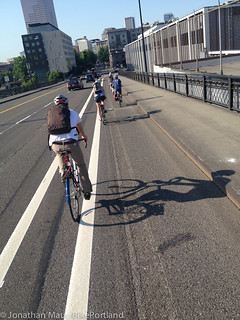
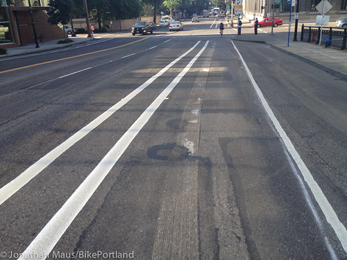
that has been scraped off.)
(Photos © J. Maus/BikePortland)
PBOT is nearly finished with a project to improve bicycling conditions on the NW Broadway ramp south of the Broadway Bridge. The $30,000 project is expected to be finished by tonight but most of the new striping was completed early this morning before rush hour.
In order to create the additional five feet needed for the buffered bike lane, PBOT reduced the amount of vehicle lanes from five to four. Instead of a five-foot bike lane and four, 9.5-foot standard lanes, there is now a 10-foot bike lane and three, 11-foot standard vehicle lanes. The change was made because of the huge amount of people who ride bicycles down this ramp and the need to create safer and more pleasant conditions for them.
I rode it this morning and took a few photos.
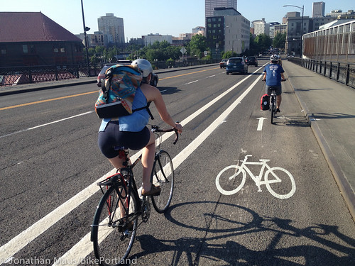
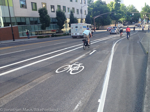
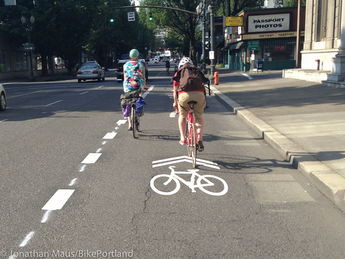
Here’s the beginning of the new lane just as you cross the NW Lovejoy intersection…
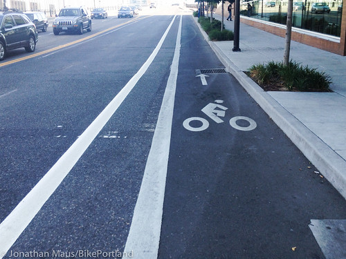
Note the old bike lane strip that has been scraped off. It’s at the front fork/wheel of the bicycle symbol…
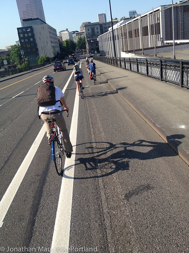
Here’s another view…
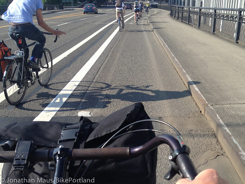
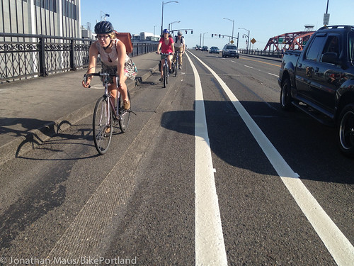
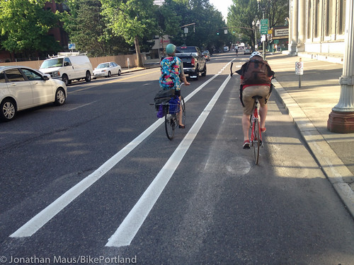
The new lane is seven feet wide and there’s a three-foot buffer on the left side. The photo below shows my handebars and a guy passing me for scale…
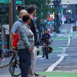
The width makes riding next to people driving in cars much more pleasant…
Then the buffered lane leaves the curb to make room for the bus stop and position riders to continue south at NW Hoyt…
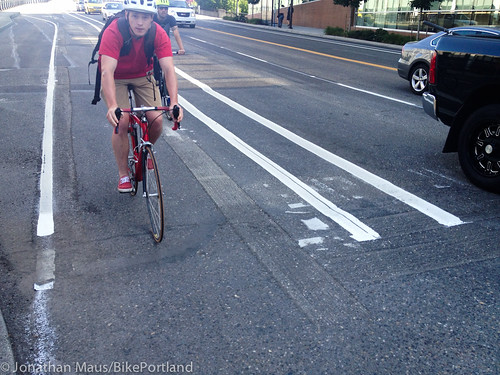
Here’s where it comes to NW Hoyt. PBOT says they plan to re-install the bike box today…
South of Hoyt they’ve created a shared-lane situation next to the buffer zone (as opposed to the curbside bike lane of old)…
Sharrows approaching NW Glisan…
Still to come are the parking rule changes (and associated signage/markings I presume). Between Glisan and Burnside, people will no longer be allowed to park curbside before 9:00 am. This will open up a nice wide area for bicycling.
Also of note is the northbound side of NW Broadway north of Glisan. Since PBOT went from two standard vehicle lanes to just one, they had room to widen the uphill bike lane and add a buffer…
One last thought: The buffer zones do not have hash marks. The schematic drawing provided by PBOT back in May showed them; but they are not installed. I asked PBOT spokeswoman Diane Dulken about this. Here’s her response:
“Hatch marks are regularly installed in buffer zones of four feet or wider. Barbur Blvd is another example of a buffer that has been installed without the hatching. So the parallel markings serve the purpose of creating a buffer without the added maintenance costs, however incremental, that additional markings would entail.”
Interesting. I think the hash marks are important. They add to the perception of separation and they communicate the intention of the space to road users. Overall, this is a nice, incremental improvement. It’s still just strips of paint without any physical separation or use of color; but it gives people riding bikes a bit more breathing room.
Have you ridden it? What do you think?




Thanks for reading.
BikePortland has served this community with independent community journalism since 2005. We rely on subscriptions from readers like you to survive. Your financial support is vital in keeping this valuable resource alive and well.
Please subscribe today to strengthen and expand our work.
The revolution will be measured in inches.
“South of Hoyt they’ve created a shared-lane situation next to the buffer zone (as opposed to the curbside bike lane of old)…”
I think that this is actually the best part of the redesign. There are sharrows in the right turn lane along with arrows making it very clear that cyclists can either turn or go straight, while cars in that lane must turn right.
Adopting this style of right turn lane could help solve right-hook problems all over the city because it makes cyclists more noticeable. I wish they’d do this on Broadway on the east side, leading down toward the bridge.
It’s a nice improvement and makes for very easy passing bicycle traffic. I both passed and was passed this morning at 8:20 when perhaps 30 riders were heading south on the ramp at once. I hope as people get used to it over the next few weeks, it help reduce the jockeying for position that some partake in at the Lovejoy/Broadway intersection before turning off the bridge to go south.
I’d like to see some warning signage or stripes where the bus and bike traffic cross near Glisan; perhaps that is pending.
I’m happy to see this improvement, along with recent updates to Multnomah, Vancouver/Morris, etc. But I would like to know why PBOT digs up old paint lines without smoothing out the resulting ruts in the road? They effectively split the bike lanes in two and waste space as people avoid riding on them.
Why doesn’t the budget include a treatment for these ruts?
How does it split the lane in two? I haven’t seen anybody avoiding the ruts…
I would guess that they don’t treat them because it would be a waste of money since it doesn’t really matter that they’re there.
except all the riders in the photos above…
You don’t know that they’re avoiding the ground down part because they’re scared of the ruts. All you know is that nobody happens to be riding in them.
Me and everyone I know avoids them. You can ride on them in a pinch but there is no reason not to ride a foot to the left or right when it makes such a notable difference with road tires.
Sample of one: I ride a heavy commuter bike with fat tires, and I avoid the ruts because they look and feel precarious. Whether they’re actually dangerous, is another question. But they SEEM risky to cross and ride on.
was just about to post this…
where I used to live in another state they used to sandblast the old markings off… just some air and sand… no asphalt grinding needed… and it didn’t leave ruts that grabbed your bike tires…
Were the markings paint or thermoplastic? I’m pretty sure that makes a difference.
It was already a pretty bumpy ride in the old lane, but the smoothest line to take has been the the former bike lane line, so I rode on the ground down line this morning. It was relatively smooth most of the way down.
I appreciate the clarified bike sharrows across Hoytt, which is exactly how I treated that stretch to begin with.
It’s a shame that PBOT won’t paint the hash marks. I think it’s clearer to drivers that it is a no-drive area when they’re there.
This part was news to me and most welcome. YAY!
They could go with the Beeswax instead of hashmarks 🙂
Where they grind the old lane markings off it leaves behind a terribly rough surface to ride on. Isn’t there any way to do this better?
they should have ground the width of the bike lane so it’s all one surface. I’m pretty sure they have a machine that does that well. Where the speed bumps were removed from SW Maplewood the pavement is quite smooth.
Wonderful! (I do wish that the hash marks were there, though. Two parallel lines are a little confusing.) I can’t imagine a DOT just taking away a motor vehicle lane without creating MAJOR protests anywhere else in the USA but Portland. This place really is special.
I love this! Especially with summer == more bicyclist that bike at different speeds. The wider lanes allow people to pass/be passed w/ less fear of the cars & sidewalk edge.
HASH MARKS, PLEASE!
I agree about the need for hash marks… wish they had put them on Holgate sooner (and still wish they’d do them the entire length instead of in groups of three)…
without the hash marks drivers can think it’s a narrow parking lane and that the buffer is the bike lane… it also helps in the rain because the diagonal lines are often easier to see than straight ones..
This. Everything you said. Yes.
Hash marks in the buffer would be helpful. I knew this change was coming, and it still wasn’t clear to me this morning (westbound) that the buffer zone was not the bike lane with parking to the right until I saw the first bicycle symbol.
I agree with the frustration over PBOT doing nothing to improve the road surface (from grinding or addressing pre-existing surface issues) before striping. I guess it makes these projects more affordable and faster?
“Between Glisan and Burnside, people will no longer be allowed to park curbside before 9:00 am. This will open up a nice wide area for bicycling.”
Excellent. A big plus for bicyclists on Broadway, and an even bigger plus as a precedent — it gives PBOT bicycle planners another weapon in their toolkit for fighting for space on the streets for bikes.
it’s called pro-time parking and is used all over Portland for adding capacity during peak hour traffic. It’s just that this time the pro-time lane is for bikes only.
I don’t understand why PBOT thinks that southbound (going downhill) warrants two vehicle lanes and an extra-wide buffered bike lane, while northbound (the uphill side) has only one vehicle lane and a narrow “shared-use path” or glorified sidewalk that must accommodate riders and pedestrians. Doesn’t this fly in the face of transportation planning? Don’t you want more lanes for vehicles traveling uphill where there is likely to be greater variation in speeds? Can’t a bicycle rider just take a vehicle lane downhill (and easily reach 20+ mph speeds) if the bicycle lane is too crowded? Why are northbound road users given such short shrift on this section?
And note, I haven’t even discussed the portion south of Glisan, which remains awful for northbound cyclists.
I definitely agree about the few blocks south of Glisan heading northbound. It’s pretty crappy. I get buzzed closely by cars in that section every day on my way home from work.
The scraping leaves the pavement in bad shape for riders without fat-ish tires. I wish they’d just tar over or paint black over the old stripes if they’re not going to repave.
Same on NE Multnomah. Same on N Vancouver.
Same on N Wheeler. I imagine they grind off the white thermoplast instead of paint it black because they don’t want to be laying down black paint/thermoplast for the next 20 years.
But, bike lanes don’t get near the road surface wear as driving lanes. It’s possible that black thermoplast would last 5 years, making it competitive to grinding.
Of course, thermoplast is slippery and has longitudinal ledges too, so its hardly a good riding surface.
I bet they could grind it a little better and not have the ledges. Seems it would be a good idea for a stripe that’s in the main riding area of a bike lane…
Ted Buehler
And, I think thermoplast is pretty labor-intensive, with the laying down of each panel, and individually heating them into adhesion; as opposed to driving a grinder up the bike lane.
I’d take new asphalt instead. Or heck, concrete :^) when they’ve got the big bucks to spend.
Maybe a petition for hash marks? Or guerilla hash marks.
add costs to a project the City barely could afford to do in the first place and take away funding for other stuff. great idea!!!!!!!
I think hash marks are very important. They need to remember that every day many drivers are on that road who’ve never been there before. Drivers licenses arent handed out by city, but can be used around the country and internationally. Its important they be absolutely clear – eve to tourists from Idaho, London or Moscow. A hash mark accomplishes that.
If they hashmark I hope they use paint instead of thermoplastic. The bumpy ones on the Hawthorne bridge are really annoying.
Great move forward
They’ve added hash marks on the buffer on Skidmore’s I-5 overpass. It’s a good addition.
Barbur could really use it, there’s a buffered bike lane for a block or so, then a parking land and bike lane for a block or two, bikes might stay out of the actual biffered bike lane and just ride in the buffer itself if they think the bike lane is a parking lane.
Bike stencils will also help demarcate the bike lane. As per the Oregon Bicycle and Pedestrian Plan, a bike lane should have a stencil in the beginning of each block.
Ted Buehler
Portland is on the cutting edge for bike infrastructure for the US.
Still, looking at this video:
http://www.streetsblog.org/2013/06/20/video-a-dutch-perspective-on-u-s-cycling-infra/
…and this blog post:
http://www.aviewfromthecyclepath.com/2013/07/the-dangers-facing-long-distance.html?utm_source=feedburner&utm_medium=feed&utm_campaign=Feed%3A+AViewFromTheCyclePath-DavidHembrow+%28A+view+from+the+cycle+path+-+David+Hembrow%29
… both from a Dutch perspective, reminds me how much scarier and dangerous biking is in the US, even in Portland, than places that are really bike friendly!
I love the use of the term ‘vehicle lane’ for bike lane. And I suppose saying ‘standard lane’ instead of ‘motor vehicle lane’ is a conscious choice as well.
As has been pointed out many times in this forum, words do matter.
Ahh yes Peter. Glad you noticed. That’s something I’ve been doing for a while now. It’s a pet peeve of mine when people say “travel lane” and then “bike lane” and/or don’t consider the bike lane as a “vehicle lane” when calculating the number of lanes…. it’s just another way bicycling is marginalized and not taken seriously. Yes. Words matter a lot.
from the photos, i do not understand the markings south of hoyt approaching glisan. is that still a buffered bike lane, with automobiles merging into the forced right turn lane toward the end? or is it shared right the way down, in which case, what is the dual white stripe for, and what is the dashed white line for later down the block?
absent all this striping, my practice has been to take the through lane immediately south of hoyt. and in preparation for that move, my practice has been to leave the bike lane as soon as i can find a clear space coming off the bridge. i might find the buffered bike lane slightly more amenable, but not if the pavement is still rough and the area is still full of debris.
There must be some confusion as to where to ride. The cyclists in the picture is riding between the lines, hugging the right side to stay away from traffic. He must not know that is a buffer lane. I wouldn’t have known either.
I like the change, despite the imperfections. Mostly, I like that the change actually *happened* and that I’m not waiting 10 years for it. I like seeing more of these buffered lanes going in as well, and auto lanes being re-appropriated (if I can use this term) to allow space for other road users. Maybe Portland does care!? Thanks PBOT!
Interstate Ave got a new stripe, unfortunately it is exactly where the old stripe was: relegating bikes to a 2′-5′ wide gutter while the vehicle lane varies from 10′ to 15’+! PBOT, please add another line to demarcate the vehicle lane at 10.5′ or 11′ to buffer the bike lane. This will create some space for bikes where possible, and more importantly, it will clearly show bikes AND vehicles where the scary pinch points are located. Interstate Ave is a key bike collector from all over North Portland, this relatively small addition could add a lot of safety!