A collision Thursday night (11/12) in the Hazelwood neighborhood resulted in the death of a male bicycle rider. It happened at the intersection of 122nd and Burnside. The incident was reported by the Portland Police Bureau without any reference to what type of road users were involved. When I mentioned the crash in a story yesterday I didn’t know the victim was a bicycle rider.
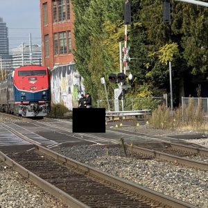
East Portland News was on the scene and was first to report details of the crash. According to their report, a responding PPB officer said someone driving a Chevrolet SUV eastbound on Burnside collided with a bicycle rider “somewhere in the intersection”. Photos posted on East Portland News show both vehicles stopped near windows at the MAX station area about 155 feet east of the intersection (see map image below). A damaged bicycle is on the ground and there’s major front-end damage to the right side of the SUV’s hood and windshield.
Advertisement
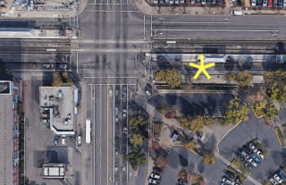
BikePortland confirmed the news with the PPB Saturday morning. PPB Public Information Officer Sgt. Kevin Allen said the crash investigation is ongoing and that officers are looking for possible surveillance video before releasing further details. The victim’s identity is still being verified with family.
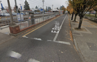
This section of East Burnside has two lanes — one standard travel lane and one bicycle-only lane. As you can see in the Streetview image, the lanes are narrow because of the MAX line that runs in the middle of the street.
UPDATE, 9:26 am on Monday 11/16: The PPB has issued an update on the crash:
The vehicle, a 2003 Chevrolet Suburban, was going eastbound while the bicyclist was riding westbound in the single eastbound travel lane. They crashed head-on. Investigators believe that poor visibility was a factor in the crash. No arrests or citations have been issued, although the investigation is continuing. If anyone has information about this crash, please contact Officer Chris Johnson at 503-823-2213 or Chris.Johnson@portlandoregon.gov.
The deceased is identified as Antonio Sage Rodriguez, 28, of Portland.
— Jonathan Maus: (503) 706-8804, @jonathan_maus on Twitter and jonathan@bikeportland.org
— Get our headlines delivered to your inbox.
— Support this independent community media outlet with a one-time contribution or monthly subscription.



Thanks for reading.
BikePortland has served this community with independent community journalism since 2005. We rely on subscriptions from readers like you to survive. Your financial support is vital in keeping this valuable resource alive and well.
Please subscribe today to strengthen and expand our work.
I just visited that intersection, Burnside traveling east is not safe for persons on bicycles. The leaves are spread wide enough the single while line delineating the bike lane is obscured. They’re piled so deep, riding through them is unsafe. The conditions persist for about 100m to the next intersection.
Coming up 122nd, there’s a wrecked mazda 3 on jacks, missing wheels, blocking half of the bike lane.
I operate the blue line. Whenever I approach this intersection I drop it to 15mph. This intersection has become absolutely lawless. Red light runners, peds crossing everywhere at all times and often intoxicated or otherwise in various states of drug induced psychosis. No enforcement. It’s just bonkers.
I see the line of people winding out of the dispensary, the tents overflowing garbage and blocking sidewalks, teens in groups drinking & smoking on the corner, aggro drivers with no plates jockeying for position like it’s a race, transients in dark clothes stumbling into traffic mid-block, daring cars to stop or run them over…
I used to think 82nd was the biggest armpit in our city but 122nd may be worse. This is the Portland that our government would like to forget.
Bike lanes are both Narrow and filled with glass.
Maintenance is far from equitable in East County. I’ve had numerous conversations with the street cleaning lead, Ryan. They are so petty that they will send a truck out to examine the area that needs sweeping before actually send a truck out a cleaning the area. SE Foster from 205 to Se 136 is downright sad and laughable.
This drives me to tears.
When can we strip our LAB platinum status and get back to work? Our laurels are dry and faded.
Dry and faded like a comfy old couch that we habitually rest on.
This is the area where the MAX system began The street design is seriuosly outdated.
… but it was “state of the art” bike facilities when it was built in 1986. Be careful what you ask for, you just might get it – and then you’ll be stuck with it forever, without the possibilities of upgrades.
When I last lived in Portland, it was less than a mile away, and I’d pass this way regularly. It was always a very scary intersection, with lots of pedestrians (even by downtown standards), lots of speeding cars in all 4 directions, including left turns, huge car dealerships next to a busy light rail station. For the longest time Burnside was the ONLY east-west bike facility AND full set of sidewalks without any gaps in East Portland, a jewel in an otherwise putrid and neglected, but affordable, part of the city.
You are correct, the street design is woefully outdated and dangerous, but even worse are the light rail stations along the way, with narrow platforms and sudden exits on to the street. I’ve nearly collided on my bike with exiting pedestrians who move too suddenly into traffic. It would not surprise me in the slightest if the driver who collided with the cyclist was completely sober and was trying to avoid an exiting pedestrian while driving the too-high speed limit (it should be 5 mph next to any of these stations, but I’m guessing it is 30 or 35 mph.)
Or else the driver was making a left turn off NE 122nd onto East Burnside, at night in the rain mind you, and collided with a northbound cyclist riding northbound in the unprotected and narrow bike lane on SE 122nd, or maybe a cyclist leaving the MAX platform.
The “fix” I’d recommend is that car traffic be banned altogether on East Burnside for just one block on either side of 122nd, blocked with bollards, and create pedestrian-only zones. Local residents and businesses on Burnside could still get access on the rest of the street, but they would need to pass through local streets to get there (SE Ash & 124th on the east side; NE Davis and 120th on the west side). Such a fix would get rid of left turns off of 122nd (and right turns too.) I’d do something similar at 102nd, 148th, and 162nd, as they all share the same awful design, but not the same volume of traffic. Obviously drivers wanting to use Burnside as an expressway won’t be too thrilled by such changes…
I’d support this. There’s already good alternate routes nearby for drivers in Stark and Glisan; no reason for drivers to use Burnside for anything more than access to local destinations. Probably good to give the same treatment to the west half of the 181st intersection too.
You could ask Gresham about 181st – they are often easier to deal with than PBOT.
There’s no reason Burnside couldn’t be bicycle ONLY from I205 to 181st. At minimum forcing drivers to turn North South off Burnside/not able to enter Burnside from every signaled Intersection from I205 to 181st. Would essentially make Burnside a local access exit only route for it’s length.
We could make it no-entry for cars but allow exiting at the major streets and force users to use local streets to get to their destinations. The street is almost entirely residential, with a fair number of driveways. The presence of light rail discouraged most commercial development. There are some high-density apartments on Burnside, 102nd-108th, near 120th, near 148th, etc. I bet most residents would appreciate having a lot less fast traffic. It would be TriMet and emergency services who would most object, plus the cut-through drivers. There is a public school at 113th (Ventura), but they face away from Burnside.
Why didn’t light rail encourage commercial development? I always thought that was one of the main reasons to place light rail instead of a bus line?
Yes that’s what I learned in planning school too. But outside of downtown and the Lloyd District, and parts of Gresham, light rail has been an utter failure in attracting new commercial development since 1986 (35 years now?) in Portland and most of the metro area. What little commercial it has attracted has been small stores and boutiques, but most office and retail near light rail was there before it was built, including the huge car dealership at 122nd. Much higher housing densities have been built near light rail stations, but it’s hard to tell if it was light rail that did it or not, or simply the city allowing and encouraging higher density development (and not allowing it in areas away from the stations.) Did it cause it, or was it random coincidence? Given the high growth in areas away from light rail such as along Belmont or Mississippi, I’d conclude the latter.
The failure of Gateway is a puzzle. If ever there were a place that should prove transit attracts density, that’s it.
I think Portland is not actually big enough – or not big enough in the right kind of employment – to support two “downtowns”.
I’ve lived here since 2006 and Downtown office space has never been tight or expensive enough, for long enough, to actually drive many office-type businesses elsewhere. There’s always enough development capacity downtown to meet the need, and as more areas get rezoned to downtown-like densities and heights, there is always going to be enough capacity.
Now downtown is emptying out because of Covid and camping, but those workers are WFH, not being relocated to other commercial centers. If businesses decide to bring workers back into the office, there will be so much vacant and sublease space that they’ll have no reason to go to Gateway. Unless, perhaps, the camping is never dealt with.
In retrospect, if the city wanted to create a triplet of commercial centers – downtown, Lloyd, Gateway – along the MAX so that almost every part of the city would be an easy MAX or bus ride, or an easy bike ride, from an office center kind of job, they would have needed to tightly *constrain* development capacity in downtown.
However, that would get in the way of development industry profits and donations, so it was never going to happen.
At this point, I don’t see much commercial future for Gateway. I think it’s best use is as higher density residential. With some retail and mixed use of course. Maybe the city can force development to set aside space for arts or local organization type workplaces. But it’s not going to be a major commercial “jobs center”.
The Multnomah County sheriffs office leaving the area didn’t help any. The homeless moved in, crime went up, and businesses started leaving.
Interesting, The light rail in Vancouver, BC really does seem to have facilitated denser development around the routes. I wonder what they do different up north? I have noticed there is a lot less free parking. For example you have to pay to park in Stanley Park. Maybe that drives demand to be closer to light rail?
https://en.wikipedia.org/wiki/SkyTrain_(Vancouver)
Great points. Yes, Portland and surrounding areas do exactly what you say–add light rail and accompany it with higher zoning, then credit the light rail for any new development. And the perfect clue that it may be the zoning and not light rail that’s responsible for the new development is that areas that got higher zoning but no light rail are densifying as fast or faster than the light rail areas.
I realize I just restated what you wrote, but it deserved to be said again.
That is really interesting. Thanks.
If light rail does not actually drive development, then buses might often make more sense given the costs. With dedicated lanes, where needed.
PBOT/BPS are working on the Sandy project, and from the last presentation I heard, they are expecting the Streetcar extension to drive development.
Cascade Station? I agree with you but Cascade Station is a counter example of a thriving transit accessible commercial area. It’s still really car-dominated and only okay for bikes.
Do you have data to support your claim?
Here is the pop growth map.
https://projects.oregonlive.com/census/american-community-survey/2010-2014/maps
2014? Is that the best data we have? That’s like 6 years ago, precovid, back during the golden Obama Age, ancient history.
On the comparisons to Gateway, Cascades Station, and Vancouver BC, this location is really outside of Gateway and its urban renewal district, and it is close to several major car dealerships and a huge park-and-ride just to the south of this crash. Essentially the local land uses aren’t generating most of the pedestrian traffic, though there is some subsidized housing nearby.
The main reason it is so busy is that the super-full 122nd Avenue bus #73, second busiest in the system (only bus #72 on 82nd rivals it) intersects light rail here. Of all the TriMet system stops, this one is in the top 5. And yet the whole street design is long outdated and neglected, as is the rest of East Portland. Cascades is much newer and Vancouver does make a conscious effort to keep stops and busier stations up to date.
To its credit, PBOT and Planning have produced plans to correct some of the deficiencies, including pedestrian islands on 122nd at Davis (one long block north), and extensive urban redevelopment once TriMet closes the Park&Ride and the car dealership sells – but that’s the rub, no one’s moving, everyone is waiting for everyone else to move, and people continue to die.
Lol, downtown ideologies in East Co will go over as well as the N.E. Glisan 102-162nd flop. I do wonder how many East Co. neither bots are among those who commute to work downtown. My guess, not many.
According to a BPS study about 10 years ago, fewer than 10% of East Portland workers commuted downtown. The largest group worked in the Columbia Corridor followed by Gresham/Troutdale, Clark County, within East Portland itself, then Clackamas County, and even a few in far off Washington County. The maps they published were quite startling – very few workers west of I-205 worked east of it, most worked downtown. The data was taken from sensitive employment records and equally sensitive sales receipt data.
That Glisan project is a mess. As is 102nd. Meanwhile because we hate enforcement in Portland, NE Halsey is like a freeway. 40 mph? What a joke people are doing freeways speeds. One home near Glendoveer just had their brick wall destroyed AGAIN from some idiot crashing into it.
Don’t worry! Once we redesign and reconstruct the street, and libertarian Oregonians embrace cameras everywhere, the speeding problem will likely abate. In the meantime, we are aware of how unfair it would be to you and your neighbors to enforce the speed limit, so you don’t need to worry about slowing down in the foreseeable future.
… of course with drivers removing license plates and no police enforcement (or police for that matter), it’s gonna be hard tracking down the scofflaws…
Speed limits shouldn’t be the same for everyone – that would be unfair and not address Equity.
I think you’d just get traffic diverted to the side streets, kind of like the Clinton diversion from Division problem, but worse.
That is usually something I worry about too, but in this specific case the nearest thru streets to the north and south are Glisan and Stark, respectively. So I’d call it likely that the vast majority of traffic would divert to those two rather than any minor neighborhood streets. Whereas in the case of inner Division the nearest thru streets are Clinton and Lincoln, in which case diversion becomes a big problem.
Oh, you’re right. I forgot the interesting street pattern there.
Please correct me if this is wrong. The width of Burnside is 17-18′, plenty of room for a PBL.
A buffered lane is possible, but the roadway needs to be wide enough so that a car may pull over to allow a fire engine to pass (a pretty tight fit as it is.)
And there isn’t enough information yet if the cyclist was even using Burnside – they may have been riding on the 122nd bike lane and got sideswiped by the Suburban as it was crossing 122nd on Burnside or turning left off of 122nd. Obviously the truck was moving pretty fast during the collision, judging from the damage impact, that the damage was on the hood and grill, and the bike got sucked under the truck.
Confused. Why would the roadway need to be wide enough for that? Couldn’t a car drive until there’s an intersection and then pull over? Looks like there are often turn lanes for people to pull over into, or at least the intersections have space.
This is the failed approach of: we’ve got to make the road easier to speed/more dangerous/likely to have more crashes, for the very occasional safety equipment to get through.
Hey Jared, this is a very common rationalization for maintaining unsafe street design. I’m not familiar with the policy here, but in NY the FDNY might require certain widths in opposition to safe design. When people double park and impede traffic this is looked at as support for these widths. The problem is often not the safe design and narrow width of the road, but the behavior of people driving that increases FDNY response time. In reality Burnside has plenty of room for a PBL, with intermittent spaces for pull over for emergency response.
Do the math and get back to us. I doubt you’ve really looked at it.
The width of the street is 17′? 10′ travel lane, 2 feet bollards, 5 feet bicycle lane.
TriMet periodically closes parts of the Blue Line for maintenance, crashes, and snow emergencies, and needs space to load and offload buses. They can park in the street, but the passengers need to be able to board the bus.
Easily solved with passenger platforms. PBoT uses these already. Or simply extend the curb for 10′ of road and design the sidewalks to incorporate bus stops and PBL ramps.
18 feet minus one foot for median shy distance is 17 feet. 11 feet for a single lane on a major roadway and truck route, leaves six feet. The standard width bike lane in Portland. A Buffer would require widening the roadway.
What is the purpose of the median foot? It only serves to preclude safe design, widen the car lane and increase speed.
I think, by the way, that the extent of damage to the SUV suggests a pretty high collision velocity. I don’t think it’s consistent with the SUV being in a turning maneuver at the time of impact.
So you figure the Suburban was crossing 122nd on Burnside? I’ve seen motor vehicles fly through there when the light is green, yellow, and about to turn red.
The way some people fly up to intersections and slam on the brakes prior to turning, it is possible they were. Either way, they were clearly going way to fast for conditions, which is typical of drivers in outer-east Portland.
If the SUV driver was crossing 122nd on Burnside, then presumably they had a green light (or maybe amber). If the bicyclist was traveling north on 122nd, then couldn’t one presume the bicyclist was crossing against the signal, which was red on 122nd? (Of course, if they cyclist was moving east on Burnside, this theory would go out the window.)
From the updated PPB press release it sounds like the deceased was riding against traffic, and possibly in the auto lane:
Thank you for the updated link.
https://www.oregonlive.com/portland/2020/11/police-id-bicyclist-killed-in-east-burnside-street-crash.html?outputType=amp&__twitter_impression=true
Bike was riding west (wrong way) in east bound lane. Hence the high collision velocity. Head on impact, if car 25-30 mph and bike 15-20 mph, that’s 40-50 mph velocity, hardly survivable.
It seems to me like road infrastructure was not a factor in this accident. Can’t Vision Zero out gross operator error.
Bicycles traveling the wrong direction is a common occurrence around 122nd, especially in the bike lanes, big pet peeve of mine. Part of it is the scale of the streets, they’re wide and crossings aren’t super convenient. But a certain percentage of people are always going to ignore infrastructure and choose recklessness, no matter what. You can install crosswalks but you can’t make people use ‘em. Same folks walk on the MAX tracks and scurry across freeways where no human should be. Then factor drugs and alcohol into the mix… and you get 122nd and Burnside.
Just this bit of new information explains a LOT about this incident.
Traveling east on Burnside past 122nd, the lane makes a very subtle kink to the left while going uphill just past the MAX station. I’ve ridden this often and I always like to put in more effort to maintain speed while being wary of cars drifting into the bike lane in this kink.
A bicycle traveling west bound could very well be out of sight of a driver proceeding east bound because of the MAX station buildings. Add to this other factors like time of day (night actually), rain, wet leaves on pavement and now approach speed as the bike was going the wrong way and you have a situation that insures a collision.
Having said this, I have been frustrated by making a left from Burnside to go south on 122nd before. It’s a complicated intersection that leaves bicycles at the mercy of left turning vehicles to trigger the left arrow. I most often make this left by proceeding through 122nd and then waiting for a green light on 122nd. This can take FOREVER especially if a crossing MAX train then resets the light timing. I bring this up because perhaps the rider was avoiding all that by a wrong way “short cut”?
Given that just past the MAX stop east of 122nd, there’s slight hill, the rider was easily going down this hill at 20 MPH without much effort. So an approach speed exceeding 50 MPH between rider and driver is very likely. In this scenario, it would have been the bicycle that would struggle to stop as it’s going downhill on wet leaf covered pavement. The Suburban would have had a much shorter stopping distance as it’s going uphill and being a 4 wheeled vehicle doesn’t have to worry about falling over when the wheels lock up.
Depends when they saw each other and attempted to brake – if they ever did.
The reason I added that last bit is that if the cyclist thought he was going to zip by the car, say in the bike lane, he may not have braked at all. If the driver thought the wrong-way cyclist was going to zip by in the bike lane, the driver may also not have started emergency braking either for rational reasons (locking up and skidding into the cyclist or something else would be a risk) or simply surprise/not reacting in time. Stopping distance at 30 mph is around 75 ft (about half thinking and half braking) and braking distance doubles in the rain.
How is the lighting there? The report mentions visibility as a factor. It was night and raining, I think. It is very possible the bike and rider had no lights – when I see cyclists wrong-waying, they never have illumination. The car had headlights, presumably, but they may not have shown an unlit wrong-way cyclist in time for the driver to react. The cyclist would have seen the car’s headlights from a distance, but he’d decided to wrong-way ride so he might have expected oncoming traffic, just thought it’d be fine.
This specific location has terrible street lighting, as the mature trees now block nearly all the street lighting from the street level (hence all the leaves mentioned by others.) Clearly the city is no longer maintaining the street trees and after 35 years those small narrow trees in the tree coffins have gotten quite large.
Just can’t get used to the “person dies in collision with person” phraseology. The person died, sadly, when a car (SUV, truck, large vehicle) collided with the person. The vehicle was operated by a person, though.
I get it: You are trying to emphasize the people in the situation and the responsibility of both parties (people) to AVOID hitting each other. The interaction of the people is indeed the key, but people don’t die by colliding with other people: they die when huge, heavy vehicles – operated by people – run into people on bikes.
May I suggest the phrasing: “person dies in collision with vehicle operated by person” or something of that nature? That would make clear that it was the collision with the vehicle, while emphasizing that the vehicle was operated by someone and humanizing the situation.
I think writers may assume their readers know that cars are driven by human beings. If the writer wants to emphasize human responsibility, that probably merits a second sentence or phrase, rather than convoluted wordage that no-one is happy with, and that isn’t even accurate – the two persons never touched each other.
It’s simple. Don’t ride your bike the wrong way in the busy road, if you do, expect that you might get hit. 100% bicyclist fault here.
It’s that simple and it isn’t. If you’re discussing who’s legally at fault, it’s simple (or seems likely to be in this case). If you’re discussing how to make it less likely it happens again, it’s not.
It’s a poor design for a street and station area – you have to either ride on the sidewalk, ride in the one-way street against traffic, or ride on the other one-way street then cross a dangerous intersection with two sets of tracks and stoned pedestrians in the crosswalk. The next track crossing is 6 blocks away at 128th. Normally I might blame PBOT for this, but this street was built before annexation, so it’s actually TriMet and Multnomah County that get the blame this time. However PBOT has had 30 years to study this mess and fix it.