
(Source: Portland Bureau of Planning & Sustainability)
“When you drive by today you might not even realize there’s a neighborhood there.”
— Kevin Bond, City of Portland BPS
The City of Portland is working to restore a neighborhood that was systematically destroyed by car-centric highway projects, misguided urban renewal plans, and racism-fueled redlining. And I’m not talking about the Albina district in north Portland. I’m talking about an area of south Portland between I-405 and the Ross Island Bridge.
The Portland Bureau of Transportation (PBOT) is working with the Bureau of Planning and Sustainability (BPS) on an ambitious project to recreate the street grid in the Lair Hill and Corbett areas of the South Portland neighborhood. Once the plan is implemented, new streets and redeveloped parcels will include multi-story commercial and residential buildings, complete sidewalk networks and protected bike lanes. Put another way, the project would extend Better Naito to Barbur Boulevard.

(Source: City of Portland)
Project managers from both agencies shared an update on the projects in a meeting Tuesday night.
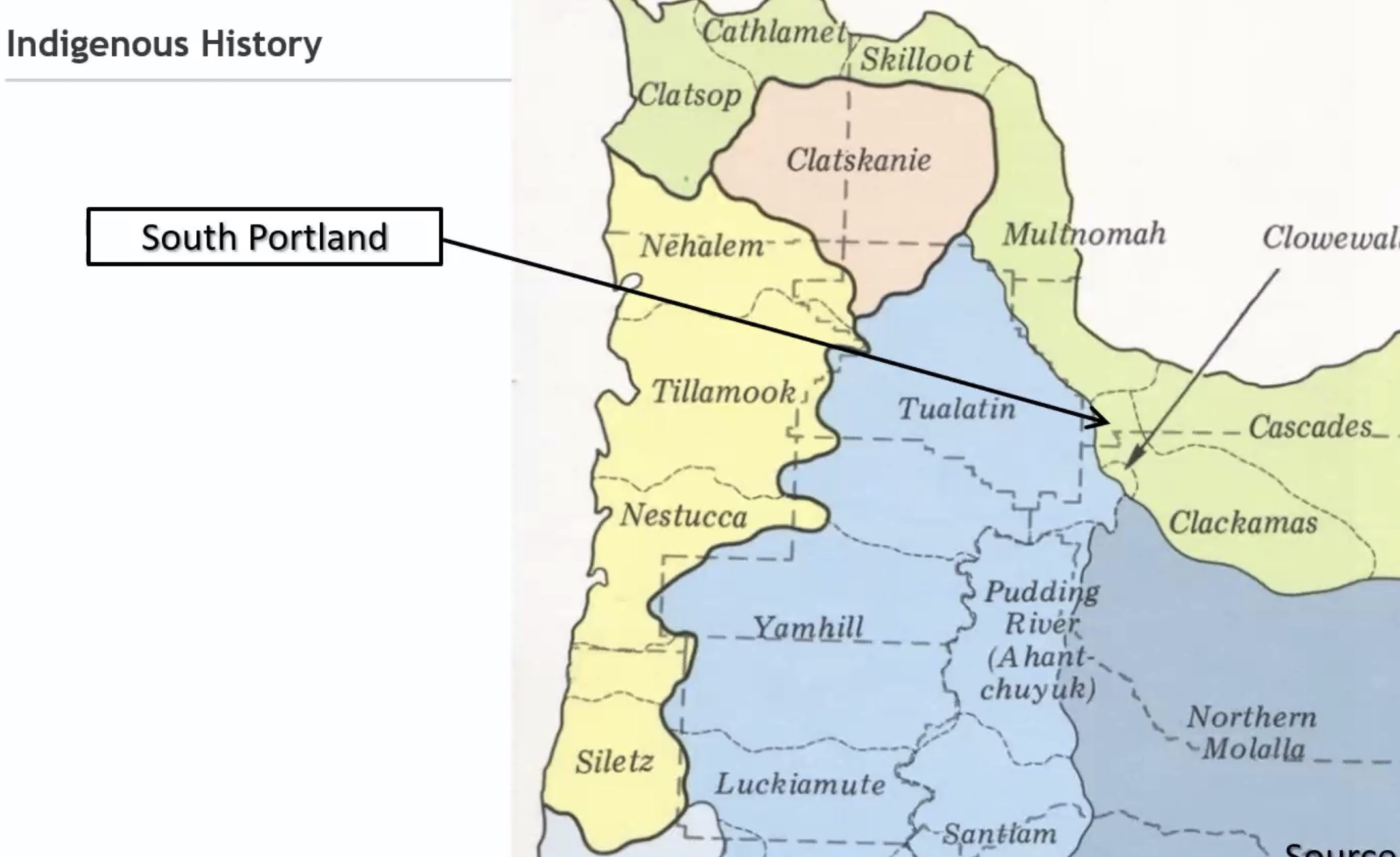
BPS project manager Kevin Bond set the context with the most detailed and honest presentation of local urban planning history I’ve ever seen at a public meeting (and I’ve seen a lot of them!). It’s common to hear land acknowledgements to honor native tribes in Portland, but Bond went above and beyond. Displaying a slide that showed the area as it looked in 1879, Bond explained, “Going all the way back to the first harmful impacts from European settlers on Native Americans, there have been impacts from past auto infrastructure projects, land use regulations, urban renewal and real estate practices that shaped the growth of South Portland for generations.” He explained that people of the Chinook and Cowlitz tribes suffered from the first wave of displacement (both physically and by disease) that came with the white settlers.
Then came the highways.
Advertisement


(Old photos of the area provided by BPS.)
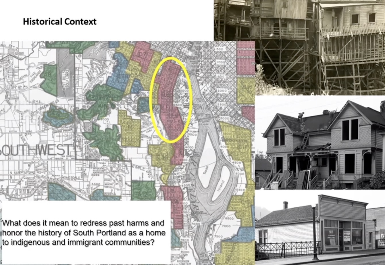
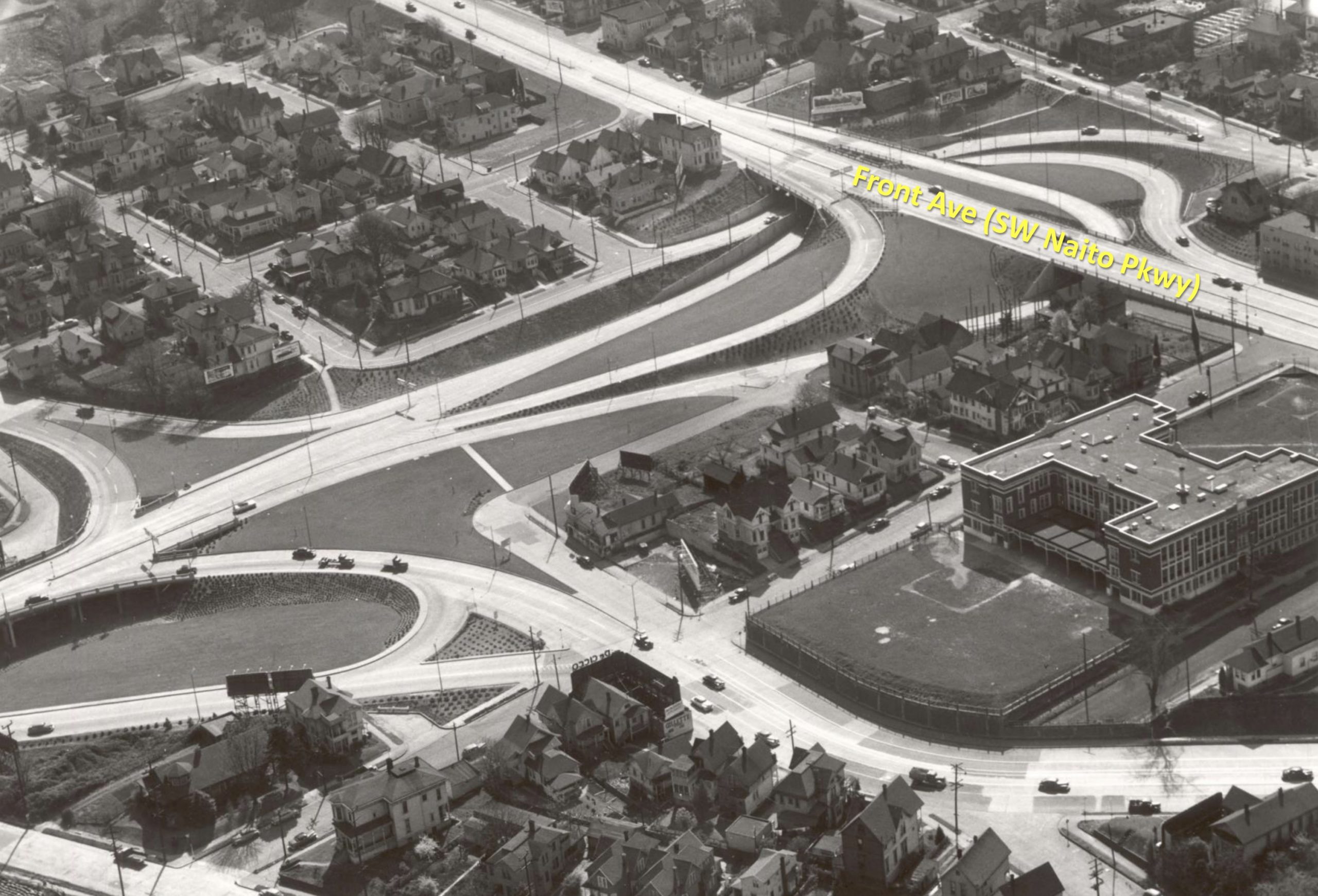
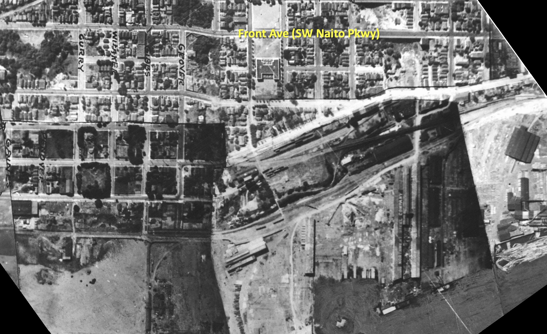
The Ross Island Bridge (U.S. Highway 26) was built in 1926 and its ramps and connections to Naito Parkway (State Highway 99W) resulted in the loss of many homes and businesses. This “highway-style road design” PBOT project manager Patrick Sweeney explained, destroyed the existing street grid and adjacent communities which were populated by 40% foreign-born residents in 1940. After the highways went in, more homes and businesses were destroyed in the name of urban renewal. City records show that the South Auditorium Urban Renewal Project displaced over 500 households, and 200 businesses between 1958 and 1974. Redlining, a discriminatory real estate practice that prevented immigrants and people of color (especially Black people) from getting home loans, also played a big role in this area. Bond didn’t just mention the term in passing, he quoted from real estate lending documents that called for a desire to keep out, “detrimental influences, such as presence of subversive foreign populations” and that, “The concentration of Orientals and other foreign born populations is confined to the northern half of the area.”
“This is restoring a neighborhood connectivity that hasn’t been in place for decades and decades and decades.”
— Patrick Sweeney, PBOT
The people who remain still suffer from negative impacts of the highways. Bond said it’s time to do things differently.
“When you drive by today you might not even realize there’s a neighborhood there,” he said at Tuesday’s meeting. “The city is committed to ensuring that new plans and new investments redress these past harms and honor the history of South Portland.” That commitment includes an equity analysis being done as part of the project that will identify who benefited and who was harmed by this past, “And how the Ross Island Bridge and Naito improvements can be designed for more equitable outcomes in the future.”
For PBOT and BPS that future means transitioning Naito from an urban highway to a more livable main street with what Sweeney refers to as, “a multimodal street network”.

While PBOT works on street plans, BPS’s role is to pass a package of zoning and street classification changes and create development concepts that will define the future Naito Main Street Corridor. They hope to have a draft plan ready for adoption by Portland City Council in spring of next year.
PBOT sees this as a “once-in-a-lifetime opportunity” to reconnect South Portland to the the central city and other southwest neighborhoods. “When you consider all these things working together,” said PBOT project manager Patrick Sweeney, “This is restoring a neighborhood connectivity that hasn’t been in place for decades and decades and decades.”
How will they do it? “The ramps come out and the streets go in,” Sweeney said.
Advertisement
Specifically, PBOT wants to remove the Naito and Kelly Avenue/Highway 43 ramps on the western Ross Island bridgehead. This will give the city three new blocks to redevelop with much-needed housing and a new street grid.

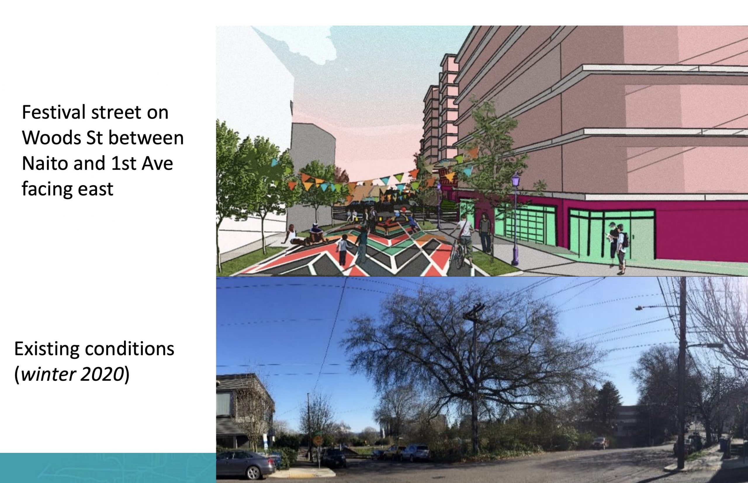
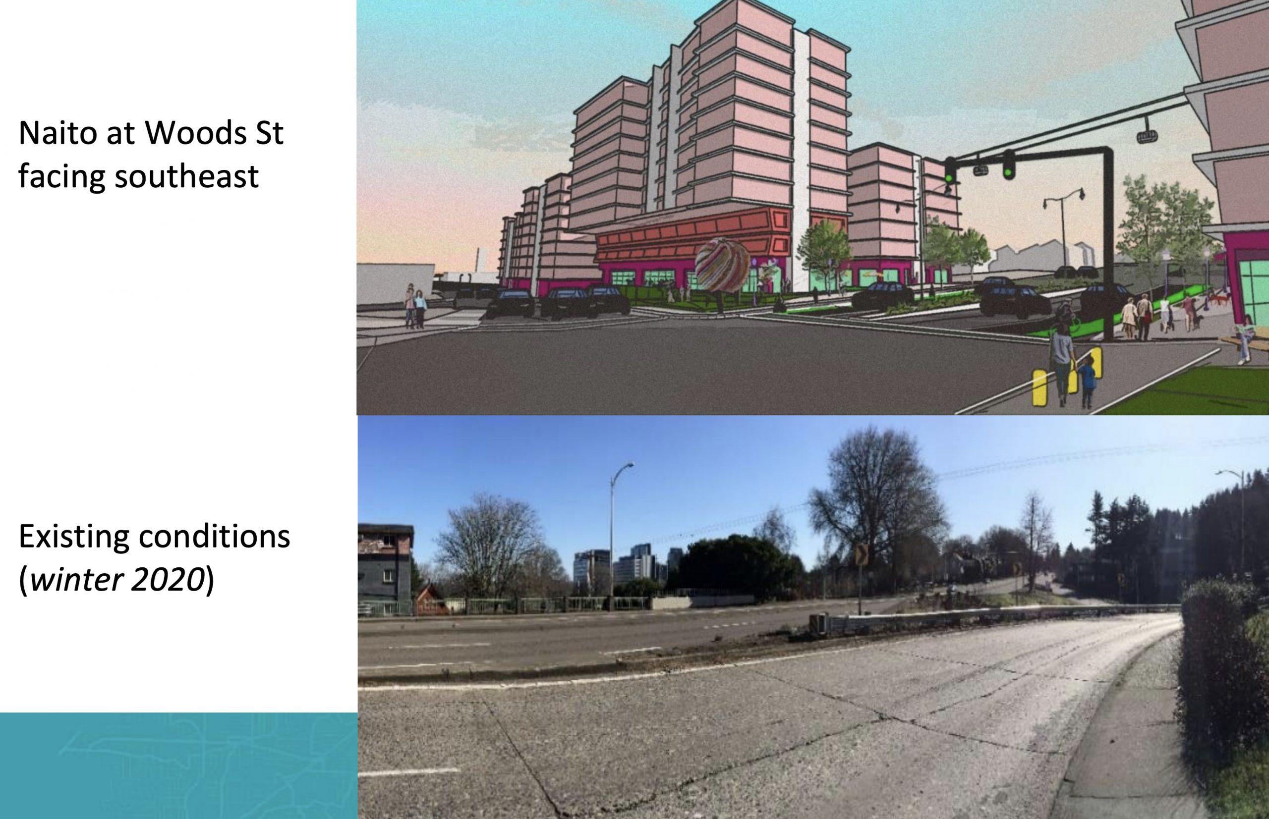
(Before/after concept drawings.)
Key to the plans is a major reconfiguration of Naito from state highway to complete street. Traveling from north to south, below are some of the new cross-sections in the works:
Northern end of the project near SW Lincoln;

The “Viaduct zone” between I-405 and south to Hooker St;

and continuing south.


The northern end of the project would tie into PBOT’s SW Naito Parkway Improvement Project which broke ground in July. And the southern end of this project will tie into TriMet’s Southwest Corridor project (if it ever gets built) at Barbur Boulevard.
Whether or not this project happens sooner or later all depends on the fate of Metro’s transportation measure 26-218 that’s currently on the ballot. It’s slated to receive $74.7 million of the $240 million set aside in the measure for a slate of Central City projects. If the measure passes construction could start as soon as 2024. If it doesn’t construction won’t start until 2028 (that is, if it earns grant funding).
To learn more about this project, see PBOT’s website or watch a video of Tuesday’s meeting.
— Jonathan Maus: (503) 706-8804, @jonathan_maus on Twitter and jonathan@bikeportland.org
— Get our headlines delivered to your inbox.
— Support this independent community media outlet with a one-time contribution or monthly subscription.


Thanks for reading.
BikePortland has served this community with independent community journalism since 2005. We rely on subscriptions from readers like you to survive. Your financial support is vital in keeping this valuable resource alive and well.
Please subscribe today to strengthen and expand our work.
That makes it look like southernmost part of Nato will be usable, should that diagram become a real construction. That section of Nato is very messed up. I rode down there once to see how it was, to cut some blocks off my commute. It was very dangerous. Cars speeding and swerving around me, just to get queued up for the bridge.
It’s like watching someone hit themselves in the head with a stick and wondering, “do they know they are hitting themselves in the head with a stick”?
Those plans look really nice, but the bike path will have to interfere with car traffic at some point. Either way, if they put the path on the east or west side of the street.
The plans above show a east-side bikeway in the northern section (to continue from Better Naito along the waterfront, which then switches to the west side of the street between sections 3 and 4 (about 4 blocks south of 405?).
Like I say, either design has complications. If the bike path is on the west side, then the bikes and cars dance at the Barbur turn off. If the bike lane is on the east all the way through, then they dance at the bridge entry via Grover. Only one option is presented, but the implied option is what I’m suggesting. To contrast.
These changes would be transformative! Naito currently cuts Lair Hill in half and has almost no traffic. And I-5 NB to Ross Island Bridge EB traffic currently gets backed up on Barbur as far as Capitol Hwy sometimes. The Ross Island bridgehead and ramps have been a terrible inefficient waste of space since I-5 was built and orphaned Naito. Will ODOT transfer Naito and/or Barbur to PBOT after this project?
I believe ODOT has already committed to transfer Barbur to PBOT following the SW Corridor project, but I’m not sure about Naito. It seems like if this project moves forward it would make a lot of sense to transfer ownership. At that point ODOT would just own the Ross Island Bridge but not the roads connecting to it on the west side.
This would be so amazing! I don’t think there’s a single person, regardless of transportation mode or what their urban planning philosophy is, who thinks that this is currently a well-designed area. In my opinion, it’s currently the worst area of Portland for pretty much any sort of transportation. This is decades overdue.
I also hope they do something about the 4th and Caruthers, and 6th and Broadway intersections that lie just outside the project boundaries. Those two intersections stack up car traffic into the neighborhoods so bad that they’re basically unlivable and unbikeable during any normal day. I don’t claim to know the solution, but the current situation is completely untenable.
I’ve got to agree with your 6th and SW Broadway Drive suggestion. And what would be fantastic is if they could put a pedestrian path along the lower section of Broadway so that people living on that hill could reach the downtown Portland transit center and PSU.
As it is, SW Broadway Dr is unsafe to walk or bike and it acts like a giant cork preventing an entire neighborhood–a neighborhood within walking distance to downtown–from actually reaching downtown, except by car.
One thing that is frustrating about the SW Corridor Light Rail project is that it runs elevated over what is already a two-level transportation mess along 405 and the streets like Broadway that bridge over it. SWLR creates a vertical third level of transit and flys over the confusion.
To some of us in the area this elevated design is a missed opportunity to improve the street-level experience of pedestrians and cyclists, not to mention motorists. There are people living immediately south of 405 who can’t reach this proposed light rail (which would pass within a couple of blocks of them) because the area so sorely lacks basic ped and cycle infrastructure.
Well said. This area’s been neglected for decades, and it shows. It’s a shame; it’s so close to PSU and thus has so much potential but that potential has never been realized.
Looks great. Too bad this kind of urban-sensitive thinking was missing when the west end of the Sellwood Bridge was being designed. ODOT vs. PBOT?
What’s wrong with the west end of the Sellwood Bridge?
They didn’t change much, they just sort of added bike staging.
It is massive and high speed. They could have simply had an at-grad, signalized T-intersection at OR 43. It would have had a fraction of the impact and been much safer. It also would be slower. ODOT builds their priorities.
I love the succinct explanation of this project: “ramps come out, streets go in”! I lived in Vancouver BC for a few years and they were doing this to their bridges, it is transformative!
I don’t disagree. I also hope that people pressure Metro and Tri-Met to rebuild the Willamette Trolley ROW, in which would render a redesign of 43 moot. It is owned by Tri-met, so if enough people nag them, it may happen.
They probably could have saved $100 million if they had just made it a simpler at-grade intersection.
What’s wrong with it? Some other comments mention some things. Basically, the whole thing is designed 100% as a context-free highway project. It looks like a freeway, not a street in a city. It was designed totally for high-speed vehicle movement. As Macadam evolves over time into an appropriately-developed urban street, it will look increasingly out of place. Luckily it’s at the south end of that vs. in the middle.
https://www.google.com/maps/@45.4668311,-122.6699273,3a,75y,139.15h,87.34t/data=!3m6!1e1!3m4!1sL83qsvzbMewDdwUn_zx6yg!2e0!7i13312!8i6656
I agree its not perfect but I’ve been riding and commuting across the Sellwood Bridge by bike since 1985. The new bridge is so much safer for pedestrians and cyclist then the old bridge. Two 12ft wide sidewalk plus two bike lanes compared to one 4.5ft sidewalk with light poles. I greatly appreciate the new bridge.
I may be mistaken, but I believe I saw an onramp planned to I405 from Ross Island (26 West). Did they take that out?
ODOT has wanted a freeway to connect the 405 freeway to the Ross Island bridge, but common sense has killed the immediate plans for that.
With rare exception I’m somewhat in agreement with ODOT in this case given a redesign (or at least ambivalent). I don’t remember if the beefed up surface streets were a part of this originally.
This proposal does almost nothing to undo the damage wrought by road infrastructure since the early 1800s or address wrongs inflicted on the Chinook and Cowlitz people living here at that time (or those whom they displaced). That said, by any standard, this area is a total mess, and these proposals look to be an improvement
Id rather live in any of the “existing conditions” photos in these articles than some cheesy AI simulated rendition of a proposal. Stack and pack must appeal to someone ?
Wait whaaaa?! You’d rather live in a satellite photo world rather than an AI simulation? Is this an argument against removing onramps, density or augmented reality?
This area is a complete disaster for all modes. Anyone who prefers the current design is just a curmudgeon.
I walked across the Ross Island bridge…once. It was a decade ago, pre-Tillikum and I was headed from SW to SE. What a mess having to walk through and around all the loops. The sidewalk on the N side of the bridge was only accessible via looping about 1/4 mile around the cloverleaf and bridge ramp on S Hood ave. I see they have since added a nice, wide path in ~2014 that cuts the corner on that one. A simple set of stairs would’ve been great, but clearly providing for people doing anything but driving across the bridge was an afterthought. It’s too bad, as the view from the north side of the bridge is pretty cool.
The city is trying to right a neighborhood blighted by racist land use policies? what?
the area is in one of the highest per capita income neighborhoods in the city and a 1300 sqft home just sold there last month for $590k. i’d say the area is doing quite fine vs. many neighborhoods on the other side of the river that could really use more focus.
can i suggest a different headline….something along the lines of:
City Helping Developers Get Biggest Bang for Opportunity Zone Tax Credit Buck, Cloaks Move as Combatting Racism!!!
Stuff white people like:
#27: Claiming that subsidy of real estate speculation and development will reverse this city’s legacy of racism.
Development projects in the Pearl and South Waterfront document the City of Portland “promises”:
https://www.oregonlive.com/portland/2014/08/hoyt_street_properties_fails_t.html
https://www.oregonlive.com/portland/2014/11/affordable_housing_in_south_wa.html
The city eventually built some subsidized housing in the Pearl and SOWA after being called out by activists but much of it was not affordable to low income people. For example, the city offers real estate developers juicy tax credits and fee waivers when they charge ~$1600/month for a 2 BR apartment.
South Portland was a Jewish and Italian neighborhood
These 1940’s west end ramps were brought to Little Old Portland by Mr. R. Moses of NYC!
The Ross Island Bridge was built in the 20s and had a very civilized west entry at the street grid. Then came Harbor Drive and the ramps in the ’40s. Moses plan also got us the I-405 loop which really put the dagger into the heart of South Portland as well as the PSU student ghetto of Goose Hollow. SW 3rd through the South Auditorium URA was the center of the Roma community. Portlanders really had no truck with “the other” in those days.
Going the other way we got a bridge so ugly even the head of the then state Highway Commission admitted it was a mistake. And then there is the Eastbank Freeway sitting where Frankfurt a.M. in Germany has a dozen museums. Not even Hitler did this to his cities!
All these freeways must be decommissioned if Portland is to survive the 21st century.
The key question is, will it include a viable safe alternative to the horrific underpass at SW Grover that is currently the only way to cross Naito?
I’ve never once used that underpass without feeling I was about to be mugged, or worse. It’s terrible. There should be a continuation of the Gibbs Street Pedestrian Bridge across at that location, instead of a dark, curved, sketchy narrow underpass.
When will they correct N/NE Portland from the gentrification that pushed vulnerable folks out?
White people co-opt everything and will never stop