
It’s been a rough week and we’ve still got several days before the air clears and we can take a full breath again. So as we roll into the weekend I want to share some very good news: On a ride last weekend I discovered that it’s now possible to ride the entire Crown Zellerbach Trail from Scappoose to Vernonia.

Purchased by Columbia County in 2004, the Crown Z (also known as the CZ) has seen many upgrades over the years. Millions have been invested to build bridges, adds signs, and develop parking and trailhead facilities. But even with a host of major recent improvements there was still a dead-end at the western end of the trail where the route went through private property. It left a tantalizingly short, 2.5 mile gap between the Wilark Trailhead and Knott Street in Vernonia. The detour around this gap was about seven miles on a mostly narrow highway with little to no space to ride on the shoulder. This gap prevented many people from taking the Crown Z all the way to Vernonia where the Banks-Vernonia Trail starts and provides another 20-plus miles of off-street riding pleasure.
Linking these two 20-mile routes has been the dream of many for a long time. Now it has come true!
While the latest Crown Z map showed the Holce Trailhead at the end of Knott Street, riders found that the land adjacent to the trailhead has been closed all summer due to active logging. That operation is now complete and the road is finally open.
Advertisement
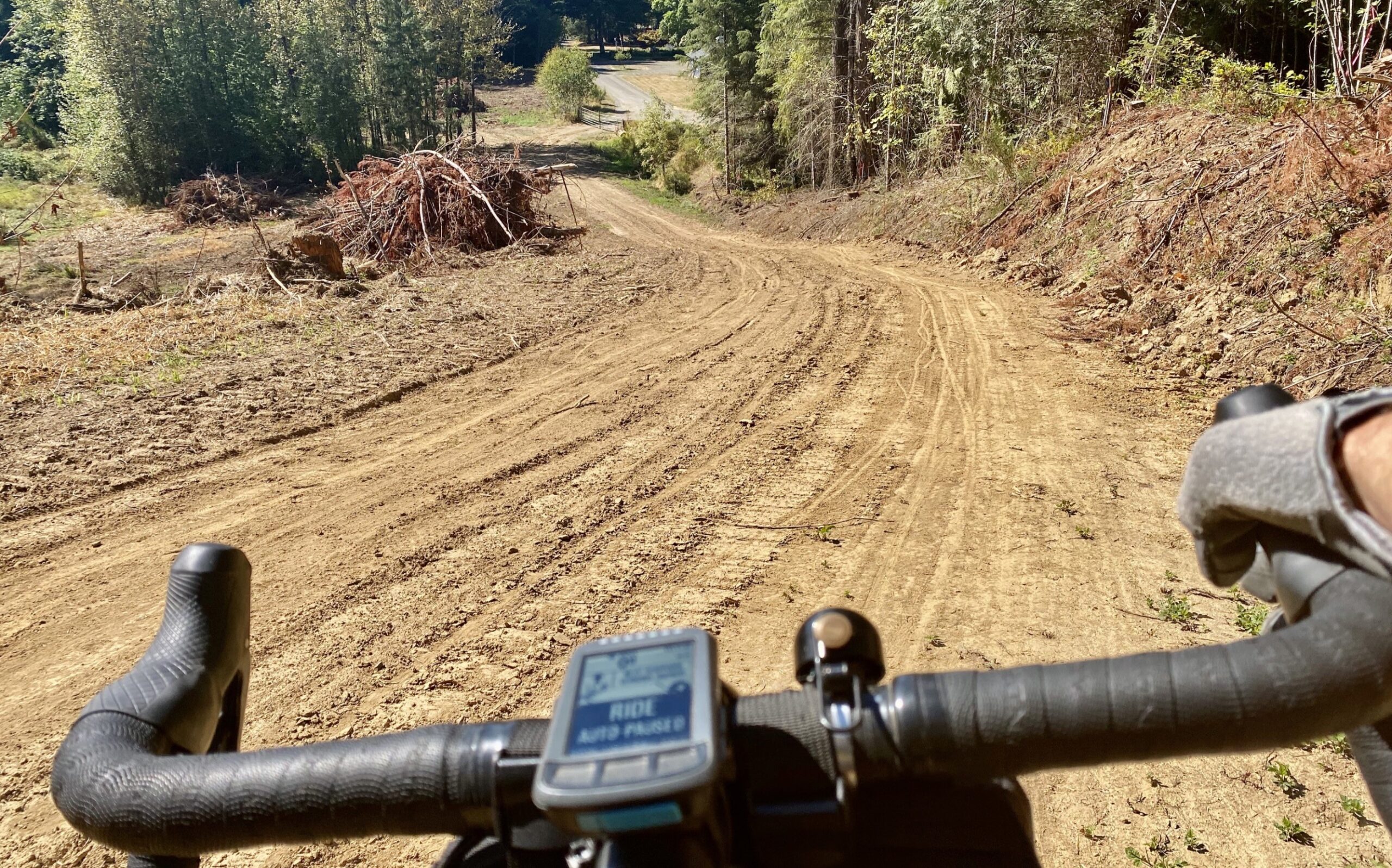
I’ve got word from Dale Latham, a member of the Crown Zellerbach Trail Citizens Advisory Committee, that riders can now get from Wilark to the Holce Trailhead (Knott Street). The official easement from the Holce family is still pending signatures at County offices, but the landowners are eager to grant the public access and you won’t have any trouble getting through.
I will warn you that the final mile or so through the freshly cleared land is steep and soft. It’s downhill heading into Vernonia, so keep in mind that it’s probably unrideable for all the but the strongest riders heading eastbound (back toward Scappoose). There are no immediate plans for switchbacks to even out the grade but that’s something that’s likely to come in the future. In the short term there will be fresh gravel so the road holds up in the rain.
Latham says this fall and winter he’s working with a professional trail builder and Travel Oregon to create new signage that makes the connection between Knott Street and Lake Vernonia/Anderson Park more intuitive.
Stay tuned for a grand opening in May 2021!
— Jonathan Maus: (503) 706-8804, @jonathan_maus on Twitter and jonathan@bikeportland.org
— Get our headlines delivered to your inbox.
— Support this independent community media outlet with a one-time contribution or monthly subscription.


Thanks for reading.
BikePortland has served this community with independent community journalism since 2005. We rely on subscriptions from readers like you to survive. Your financial support is vital in keeping this valuable resource alive and well.
Please subscribe today to strengthen and expand our work.
Awesome news! Thanks Jonathan. Wish there was a safe way to get to the Scappoose trailhead from Portland.
I see the word “safe” on BP with regularity. What does “safe way” mean in your comment?
Presumably it means a bike route without a lot of high-speed cars in very close proximity.
A modicum of separation between the cyclist and 60mph semitrucks.
Suburban, I have thought the same thing many times. Safety is not binary, safe/unsafe. Safety is a function of risk, and risks while cycling vary depending on a rider’s skill and conditions. US 30 is certainly uncomfortable, but based on the amount of use it gets and the # of incidents, I am not sure how you can say it’s “unsafe”.
At the very least, the concepts of “safety” and “safety” are far more complex and nuanced then they are regularly used in these comments.
I would argue that a highway averaging multiple deaths per year is unsafe, but I guess we all have different standards.
Yeah you and me both. Until we get a bike path along the rail line on the east side of the highway (big dream)… I’d really like to establish the entire Hwy 30 corridor between NW Portland and Scappoose as a “Bicycle Safety Corridor” given its extremely high value and popularity as a place to ride. I’d love for ODOT to create that program alongside their existing Safety Corridor program but add a few bike-specific regulations like lower speeds, high traffic violation fines, signage, wider and protected bike lanes, more sweeping/maintenance, and so on. Will take lots of work at the legislature but it’s a dream project for sure.
I’d take a 10 mile, mud-filled ditch as long as I didn’t have to ride next to 50+ mph traffic. But a path along the RR sounds decent as well. How about another trail along the slough at Burlington Bottoms?
I imagine obtaining easements from multiple landowners would be a challenge, but it looks to me (based on Google maps) like there is at least the potential to create a mostly-riverfront bikeway from Linnton to Scappoose. It would mean linking low-traffic roads and private roads serving marinas with new trails across forested land, some of which is in public ownership and some of which is private. That wouldn’t connect all the way to Portland, but it gets most of the way there.
Jonathan: I am interested in dedicating some significant time over several years to creating a bike path and/or safety corridor along Hwy 30, but I’m not sure where to start. Call me if you have time to explain your ideas more. 503 754-8424
Keep me in the loop Dale.
Can you take the bus to Sauvie island and ride Hwy 30 from there? The shoulder is significantly wider past the island.
Hadn’t considered that. Good idea.
There is a very safe way. Put your bike in a car and drive there.
Ha! I wondered what happened to the end of the CZ. I got lost out there one night back in June.
After reading here about Jonathan riding through the night doing the Oregon Outback a few years ago I wanted to do something like that. Two years ago on the solstice I did a Pedalpalooza ride but it there were many breaks for getting high and I wanted to ride not sit around for 45 minutes and get high. Last year I posted a solstice ride to follow the Ronde PDX route. One guy showed and we dropped the first portion up Saltzman to start climbing up to Pittock mansion. He crashed decending and I bailed. This year I decided to ride through the night on my own.
I started at 9 pm and climbed up Cornell Rd to Skyline and then followed that all the way out to Rocky Point Rd which drops down back to Dirty 30 a few miles outside of Scappose. I started up the CZ around 12:30am on a rigid mtn bike. The CZ was too bumpy for me so I got back on the road. I have a generator lighting system but around 1am I turned off the light and rode for the next hour or so climbing up the road towards Pittsburg without any light. It was so quiet and peaceful. I think maybe one car went past heading the opposite way in that hour.
The CZ is really well marked. I rode it last year in March and there weren’t all the maps at parking points that there are now. This night I was riding without a map or gps. I knew the route and after checking the map online and verifying that night on trailside maps I figured I could cut off the road at the Wilark parking area and get to Vernonia without any problems. The trail is double track after you cross a small bridge. I started climbing up at about 2:30am and it is a tough climb. Most of the trail is well marked and I’m riding along feeling good like I’m going to get into Vernonia around 3am and be to Banks by 5am. There are some twists and confusing offshoots but the CZ has markings and I’m feeling confident that I’m going the correct way. But then the trail just disappeared and I’m wandering through the forest on something that looks like a path but not really. After a few minutes descending I pop out into the logging operation Jonathan mentioned and I knew I wasn’t in the right place. I back tracked and looked for any sign of where I went wrong but couldn’t find anything. I then backtracked all the way back to the Scappose Vernonia highway and then pushed hard and got to Vernonia by 4am. I bonked after the long slow climb to the switchbacks on the Banks Vernonia and it took me an hour to go 10 miles downhill to Banks! I made it to the Max station in Hillsboro and got home by 9am.
The next day I told my friend that the trail just disappeared on me. She thought I got lost. I was confused because the maps had shown there was a trail to Vernonia but not that I could find that night. Thanks for clearing this up for me!
Amazing story!
Exciting! If not for Ride with GPS routes, I’d likely never have made it to Knott at the west end of CZ. Very confusing final section, and steepness. But that road in the photos shows as a huge improvement over what was there before, which was not much of a road, and hardly a trail. Thanks BP for the update!
If anyone’s interested in what a ride from Portland to Stub Stewart via CZ looks like, here’s my recording from about a month ago on a very hot Sunday afternoon:
https://ridewithgps.com/trips/54470830
The last segment of CZ is pretty steep & sandy but I didn’t have too much trouble on relatively skinny 700×41 tires. Signage is great until the berm (where the logging happened recently) but the route is obvious from there.
Great article BP! I want to add that although it would be great to modify the new connection to include switchbacks, it’s not likely to happen due to constraints in the easement and terrain. I’m sorry if I gave a different impression. Also, I couldn’t agree more with the sentiment of creating a safe route from Portland next to Hwy 30 to the beginning of the CZ Trail in Scappoose. We should start NOW to make that a reality to coincide with the opening of the Salmonberry Trail in several years. If we can connect the CZ to the BV, we can surely replace the Dirty 30 with a safer bike path. I’m willing to work with any of you who are like-minded. Let me know if you are interested.
Fantastic news! I didn’t even realize that was happening. That 2.5 mile gap looked a lot more dicey to my eyes than riding on Dirty 30, and is the only reason I haven’t ridden the loop from Portland.
Great news (and much thanks to the Holce family (and others) for allowing the public access through their property. I hope people will respect this opportunity. (Perhaps a ‘thank you’ sign can be added to each end of the easement similar to :this road is cared for by “x” group.)
And…with the strong work of Oregon to make these regional walking and biking connections…it just makes me wish more for a Frog Ferry (foot ferry) stop connecting Frenchman’s Bar Park and Sauvie Island…so as to bypass all the unhealthily city traffic the current route requires from Vancouver.
Another bridge to Sauvie Island at Chapman Landing park would also be amazing.
Sad thing is, all the money that goes into building these trails and cyclists still ride on highways with no shoulders. Sometimes as a pack and no give-way. ie Hwy 47.
Sad thing is, all the money that goes into building these highways and drivers still use neighborhood streets as cut-throughs. Often as a pack and no give-way, always over the speed limit.
Wow, ok…
1. Not every cyclist lives close to these trails, and many don’t want to have to drive just to get to a place to ride. Typically, the only connections to the trailheads are via the highway.
2. Many trails like this require a bike that’s capable of taking on some rough off-road sections for at least a part of it. Most “packs” you’re seeing on the highways are likely almost completely comprised of road bikes with slick, skinny tires that work great on the road but aren’t designed for more rugged terrain.
3. A trail like this is great for recreation, but not as likely to be used for someone commuting or running errands.
4. Cyclists are legally allowed to be there. When I’m riding in a group on a stretch with no shoulders, the only time we don’t give-way is when it’s unsafe to do so. Unfortunately, the perception of safety is often much different to the person encased in thousands of pounds of metal.
5. I know it can just feel wrong when you’re behind the wheel, but it’s OK to drive slowly until it’s safe to pass 🙂
I first rode the CZ yesterday. Great fun in the woods.
As of a week ago there are still signs on the east end of the Wilark to Knott segment saying that there is logging going on. Given that the gravel in that section is large and loose (I was on a road bike,) and things were a little wetter than I would have preferred, I went ahead and did the 7 mile detour rather than go investigate if they were indeed logging, (they probably weren’t on a weekend.) If the sign is still up the next time I try it, I’ll go check it out anyways.