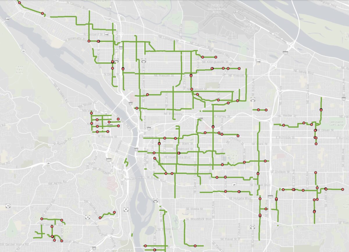
PBOT has kept their promise: They just shared a map of the first 100 locations that will receive new temporary barricades to restrict driving in the name of their ‘Slow Streets Safe Streets‘ initiative.
The first barricade installation will be this coming Thursday (May 7th) and new signs will be up shortly thereafter. The design of the signs and the expected intersection treatments were also just released.
Advertisement
Here’s the official verbage from PBOT about the locations and treatments:
The first step of this initiative focuses on neighborhood greenways — PBOT is installing temporary barricades to either close certain streets to all but local traffic or to slow traffic where a full closure is not feasible. The bureau will also install signage to alert drivers to the presence and priority of people walking and biking on the greenways.
PBOT has identified a first set of 100 neighborhood greenway sections that we will put treatments next week (starting May 7th, 2020) — these are locations where greenways intersect with busy streets and have historic high traffic volumes.
Note: the dots on the map indicate where a location will be treated with temporary barricades and signage. Additional signage will be placed throughout the neighborhood greenway network.
Here’s the geographic breakdown:
— North Portland: 10 locations
— Northeast Portland: 31 locations
— Southwest Portland: 9 locations
— Southeast Portland: 44 locations
— Northwest Portland: 9 locations
You can view the exact intersections in this spreadsheet we’ve uploaded to Google Drive.
And here’s what the official signage will look like:
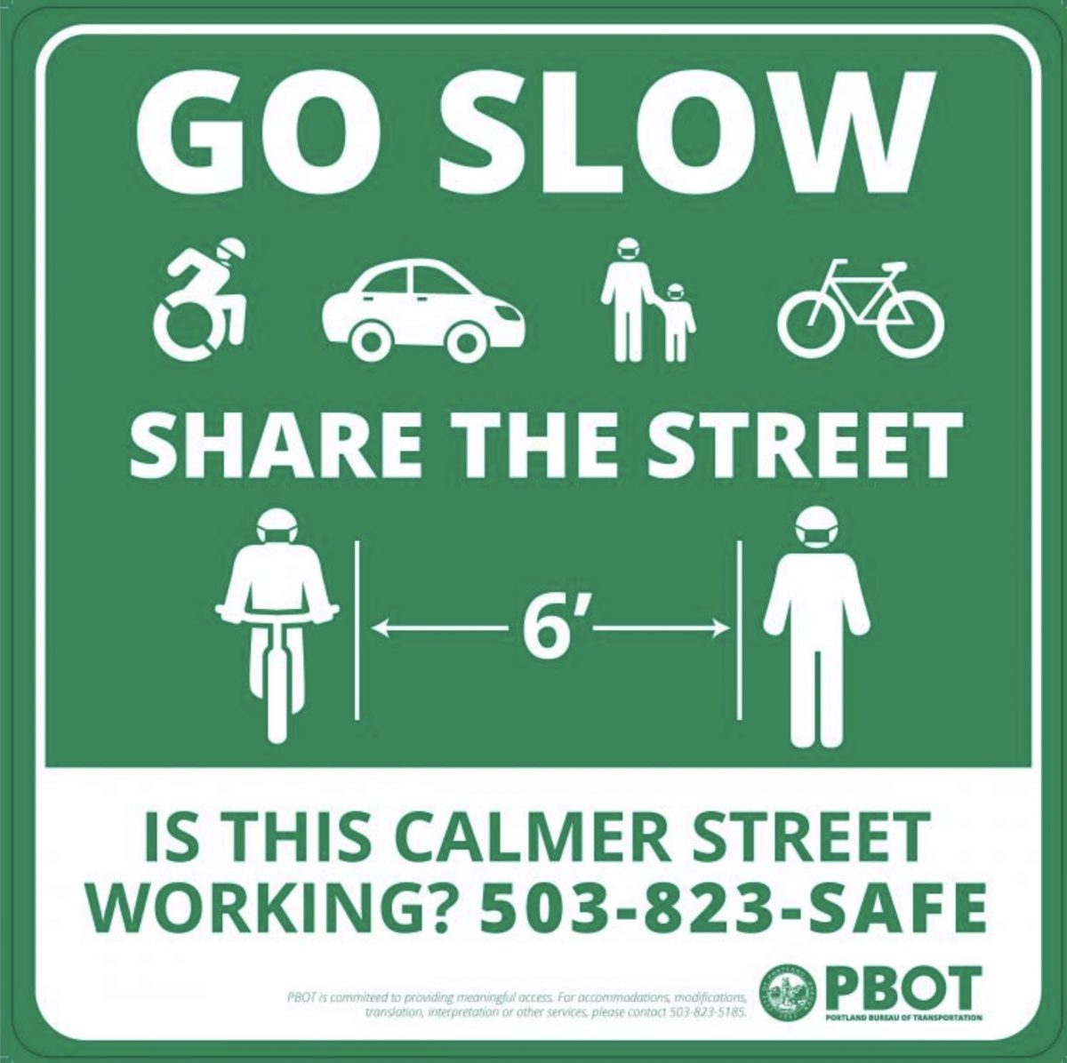
Interesting how they’ve made the feedback line so prominent. That’s a great idea.
Advertisement
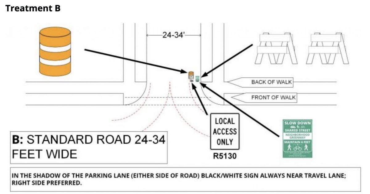
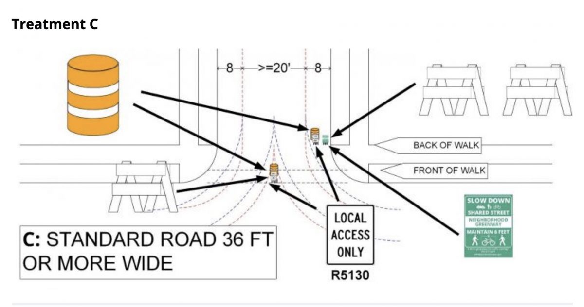
PBOT has also shared the plan drawings of how the signs and barricades will be installed:
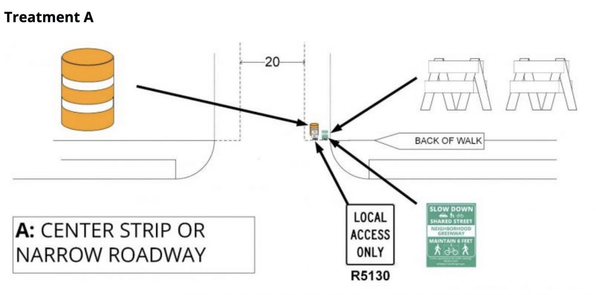
Outreach on this initiative has yet to begin. PBOT says digital meetings will be held “in the coming weeks”. For now they’re accepting suggestions for locations where, “street improvements could support safe physical distancing.” If you want to submit an idea, call 503-823-SAFE or email: active.transportation@portlandoregon.gov.
— Jonathan Maus: (503) 706-8804, @jonathan_maus on Twitter and jonathan@bikeportland.org
— Get our headlines delivered to your inbox.
— Support this independent community media outlet with a one-time contribution or monthly subscription.


Thanks for reading.
BikePortland has served this community with independent community journalism since 2005. We rely on subscriptions from readers like you to survive. Your financial support is vital in keeping this valuable resource alive and well.
Please subscribe today to strengthen and expand our work.
I’m actually pretty impressed with this. Pleasantly surprised.
Anne Hawley!
We missed you! Welcome back!
So these are just advisory signs, not actual diverters?
Actual diverters are pretty complicated, because they affect business access, emergency response, driveway access, all kinds of things. Sometimes a median diverter is better, sometimes a semi-diverter, sometimes a full or diagonal diverter. They have to be thought through and designed. You can’t just throw down 100 of them overnight. So it makes sense that these would be advisory only. You can technically drive around them if you have to, but you’re not “supposed” to. It’s aiming at a culture change, a reminder to be extra careful if you have to drive on that street, and to avoid driving on it at all if you’re not heading to a local destination.
What do you mean by “diverters”? Obviously they aren’t going to pour concrete. And the plan for this phase doesn’t include those big concrete planters we’ve seen them use. Just going to be sawhorse-style barricades and signs.
Yeah, I was thinking about those concrete planters that are effective and impermanent.
From your post on Wednesday: “The initiative announced yesterday would beef up existing neighborhood greenways by adding more diverters and signage — the same stuff we’ve done for years and that activists have pushed for all along…”
This looks like it will be a barrel and sawhorse with sign at the edge of the road, or in the middle if it’s really wide. Really just signage and not a diverter. The sort of thing that is easy for an entitled motorist to ignore.
I’m not attacking you, JM. I’m just disappointed that it’s nothing more than signs and hopes.
It sure does look like sawhorses with signs on them. Are the saw horses going to be placed in the street blocking auto traffic? That’s a bit more (and better) than I expected.
I guess we’ll have to wait and see to really be sure. My take from the materials is that the sign-holding sawhorses will only be placed at the edge of the road, not across the whole thing.
Going to be interesting to see how long and how deep you can keep this up ?
Nobody here under the influence of a psychopathic shrew. . . .
Thoughts AND prayers!
I could cry looking at the omission of lower SE Portland (as well as SW Portland).
It’s a good start. Let’s hope more is on the way soon.
Agreed, this really underscores the existing gaps in the network. My neighborhood (Brooklyn) won’t see any changes because we have zero existing greenway miles.
I totally agree. Hardly anything south of Holgate which is such a huge area for transportation and recreational cycling
This is phase 1, the easy stuff. I’m guessing that phase 2 will have the arterial buffers, especially in SW and East Portland, given the diagrams that PBOT has already put out.
It’s PBOT so of course the outer east side gets ignored again. Why did we expect anything different?
I agree and I think there is no reason to say “this is enough” because that only gives them more excuses to slow roll a fix which should be ubiquitous all over the city. Good work peeps, but not enough, not nearly enough
Same as it ever was. This area of SE Portland often gets the short end of the stick (And they more often pay a higher rate of property taxes too!)
This is a good start! Bummed to see that 7th didn’t get much love except for right near Irving Park. I would be willing to take that rougher climb to avoid more people on Williams. I rode out to Rocky Butte today from Peninsula Park, and found an awful lot of drivers on sharrowed roads (Holman, Fremont past Sandy, etc.). Pedestrians walking in the road (which I know is good), but they would dart left in front of me as I tried passing, lol. Trying the tolerance approach, and I’m grateful we’re doing something!
If the goal of this initiative is equitable provision of safe space for physical distancing, this first step is a misstep. By committing to only the 100 spots on greenways for the first move on this initiative, Chloe already started on the wrong foot; there are entire swaths of town that don’t have greenways. The error is compounded by not significantly upping the density of treatments in those areas where the network is scant.
PBOT mentioned earlier this week that traffic volumes on some key existing greenways are waaaay down—well within the ranges they target. Why focus first on a network that is already low volume and has existing treatments in place to control volumes? A focus that so clearly leaves some of our most vulnerable community members behind. What about providing space in places where there isn’t already at least a suggestion that cars are guests and pedestrians belong?
Damned if you do, damned if you don’t.
You’re right in that no matter how she responded, someone was going to grumble.
But this implementation is an unforced error. Anyone who has lived in Portland as long as she and been ensconced in the heights of city politics for a couple years knows (viscerally and intellectually) the investment story of east Portland. And it can easily be seen that doubling down on that existing inequitably drawn and reinforced network will exacerbate the disparities we all know of.
This is elementary.
We definitely live in two very different Portland’s: one west of 82nd and the other east of.
Why not unite the various parts of Portland by creating a central east-west pedestrianway?
From ideas I got while traveling in Europe, I’d start with the Thorburn Expressway from West Burnside at 23rd to SE Stark at 162nd. Create a continuous and permanent Open Streets motif. Use the same tools you would for blocking neighborhood streets to block signalized intersections – force local residents to use side streets to get to their destinations, not unlike what bicyclists must currently do to get to main street destinations. Make the street speed limit 20 kph (about 13 mph) so that cars, buses, and trucks are “guests” on the street, sharing it with pedestrians and other users. Allow and encourage local restaurants to expand seating into the street to allow and encourage social distancing of patrons and staff in commercial areas, especially in Uptown, downtown, Kerns, Montevilla, Hazelwood, and Rosewood. In residential areas, encourage street art and pocket parks. In East Portland, Stark has a lot of the poorest people in large apartment complexes, so the street would simply be an extension of their apartment complex entry, but with a lot more amenities such as parks, seating and green spaces. Bus #20 already serves the whole route, so it could be converted into a DC-type circulator of a $1 fare and much reduced speeds. There’s no reason the street traffic-path would need to be straight anywhere, not at 13 mph. Emergency vehicles could still get through, but they’d have to move much slower and navigate more carefully.
No, they are just at the damned if you don’t phase. I’m putting half-measures under “didn’t” for now
Ok now do the other side of the river?
I biked most of the Lincoln St. greenway yesterday (downtown to Montavilla – where I work as a caregiver) and the car traffic honestly felt surprisingly heavy. Bike traffic also felt way higher than normal, and at times it almost felt like Sunday Parkways – except with a few random inpatient drivers. Now, I’m not wanting to complain – Lincoln is much better now than it used to be since they added the latest diverters. I just wanted to point out that car traffic appears to be picking back up again.
Sidenote: my favorite part of the route was the section of Harrison through Mt. Tabor park, which is completely closed to cars. It would be cool if that could remain permanent.
I agree with you, though, that the implementation of this should start with areas of Portland that already have less infrastructure!
Agreed, I’ve lived in the area for almost 7 years and often take Harrison through Tabor on my commute. It’s become increasingly popular for “cut through” drivers recently. I too wish they’d close it down permanently.
“Why focus first on a network that is already low volume and has existing treatments in place to control volumes? ”
Because it’s the easiest thing to do and thus can be done very quickly. Do you think it’d be better to spend a month rolling out a better project, or knock out some low hanging fruit in 1 week then move on to the harder stuff?
I think the latter makes sense. And I’m in North Portland, where we are getting all of 6 “diverters,” compared to about 17 east of 82nd (by my quick counts).
Wow, North and Northeast kinda got the short end of the stick here, huh? Maybe it’s just my personal habits, but I’ve long considered Tillamook & Going to be two of the main East/West greenways, and neither are getting meaningful love here? In SE it looks like Lincoln/Harrison got the shaft, but there are already diverters a couple places there.
There is ONE diverter in the rectangle of I-5, I-84, the Columbia, and NE 33rd. I don’t understand why these can’t be peppered through neighborhoods all over Portland, regardless of whether they have greenways. There are arterials within a few blocks of pretty much any Portland address. Driving off of arterials should be really annoying for more than those few blocks.
Sorry I should have said MLK as the west boundary. There are actually a whopping 3 if you go to I-5.
It actually looks like northeast and north got the most attention.
Over here in Bend, the Safer Streets have been implemented, but in a pretty ‘wimpy’ fashion. Big 6′ highway signs were put up a couple of weeks ago saying No Through Traffic . They worked for awhile, but now I notice drivers are just ignoring them and traffic is back to normal. Tiny, like 8″ signs were put on the roundabouts, but way too small for a driver to read. On top of that, former good cycling streets, like 4th Ave have been screwed up with supposedly pedestrian-oriented corner push-outs that block former cycling lanes, as well as forcing right-hand drivers to make very dangerous turns that take them into oncoming lane. I actually saw cars swerving to miss each other yesterday. one step forward, two steps back.
Disappointing because this ignores pretty much all of Woodstock/Mt Scott-Arleta, and Brentwood-Darlington. These areas lack greenways and have pretty lame bike infrastructure, but there’s nothing meaningful for residents of these 3 areas in this plan.
Yeah, I’m super bummed about this, too. Hopefully we can expand and build out our greenways because of the dire need for them now.
I used open data from Portland Maps to figure out where the existing permanent diverters are, and mapped the temporary diverters, permanent diverters, and added in planned and recommended greenways in addition to the already built greenway network, and put it all on one map: https://www.arcgis.com/home/webmap/viewer.html?webmap=fd9db7ccb2a0478590221aa15d697fc7
The existing diverters definitely make some of the greenways look better, but adding in all of the planned and recommended greenway routes which haven’t been built really highlights the gaps in the current network.
Please feel free to share the link, I think it helps to show the bigger picture.
Great map!
I’m more familiar with East Portland and connections towards downtown, so I’ll address those:
– There’s a bike bridge over 205 at Lents Elementary that connects two green lines on your map north of Foster. I note the Failing bridge in also missing. Maybe add a bridge symbol?
– There are bike paths in the city Ed Benedict park at the west end of SE Bush connecting the north-south route.
– City and ODOT bike lanes are all missing on your map, particularly those on Burnside between 68th and the city line, but also on Powell, Division, etc. East Portland has a lot more bike lanes than inner portland, a legacy of Multnomah County planning.
– The Multi-use paths are all missing (Springwater, 205, 84, etc.)
– Some of the ‘recommended’ routes you have are good only if you are a fearless MAMIL rider willing to ride on a collector without a shoulder. Folks 8 to 80 would likely avoid the sections of Main east of 162nd, 148th north of I-84, and Fargo between 102nd and 122nd (an off-ramp for I-84, believe it or not).
Thanks David! I’m using the data provided by PBOT’s open data via portlandmaps. I chose to focus the map on existing and *planned* greenway routes specifically, and excluded the MUP and bike lane layers, because the original PBOT map showed greenways and this effort is mostly focused on greenways and similar streets at the moment. However, if you want to see the full network, I provided an option for that, it’s just off by default. If you click the “content” tab on the left sidebar of the map page, you can toggle on “full active bicycle network” and toggle off “combined bicycle network” to see all active (excludes planned/proposed routes) bikeways, color coded by infrastructure type. This includes all MUPs and bike lanes in PBOT’s data.
Odd. When I turn on all the layers, the 4M is missing (SE Market, Mill, Millmain, & Main, 92nd to 174th).
I only included greenways on the “combined bicycle network” layer which has “planned” routes, and only included “active/built” segments on the “full active bicycle network” layer which has non-greenways. If you enable the “Bicycle Network” layer which is the full raw data from PBOT and zoom in far enough you’ll see all those sections you mention, but that layer with full detail doesn’t render completely when zoomed out beyond a mile or so because there’s too much data. I created the two layers above by reprocessing it into contiguous segments so it could show better, but I had to be selective about which data to include because it takes a long time to run and costs ArcGIS credits. It looks like I accidentally had that layer filtered to only active, but I’ve removed that filter.
So ALL 2 wheeled, vulnerable, slow moving road users are allowed on the greenways, right?
My recycled, reused, 100mpg motorbike tops out at 30 mph and I would get run off the road trying to take the lane on Powell, or even Foster with its reduced speed limit. I’ve already been in 2 car vs bike wrecks, (with the driver not even stopping the second time) when I use main roads so I try to take the side streets as much as possible.
Yes, I’m well aware that most of you hate anything with a motor, but I really can’t afford a $3500 e-bike so I’m pretty content with my $300 motor+pedals bike.
So does this map include the obstructions already in place? I see two red dots at the west end of Clinton St. There already is one barricade on about 17th and another at 32nd. The two red dots on the west end of the street look to be at 26th and 21st, which seems like overkill for one half mile of street.
It does not, but I created a version of the map which does: https://www.arcgis.com/home/webmap/viewer.html?webmap=fd9db7ccb2a0478590221aa15d697fc7
Clinton doesn’t have diverters at 21st and 28th, and that stretch specifically gets a LOT of cut-through car traffic, so I think it’s a very sensible place for them.
I’m curious about the SE Lincoln and 60th intersection. How is TriMet negotiating that diverter? A, B, or C style? SE Division and 60th are too sharp for the Southbound buses.
Well, sounds like it’s all sorted.
Interesting to me that the sign shows a cyclist wearing a mask.
Way over their heads
One thing I’ve heard, but don’t know if it’s true, is that Portland Public Schools has closed off several fields/open spaces to people. I understand there could be some justification to that if true–need to close sports fields to avoid people playing group sports, etc. But it seems inefficient to have PPS removing areas that lots of recreation seekers (walkers, joggers, kids biking or playing) would like (or prefer) while those same people are adding to the demand for street and sidewalk space, placing a greater burden on PBOT.
You wouldn’t know we’re in the middle of a
pandemic based on all the families playing at the elementary school near 71st and Woodward. My wife, dogs, and child walk through there all the time.
I guess the most shocking thing to me about this map is that it has made me realize just how awful slash nonexistent the greenways network is in SW Portland. I’ve seen the markings on the pavement but never paid much attention. We have a grand total of one steep-ish and very bumpy street between Terwillger and Hillsdale, and some neighborhood streets in Maplewood that don’t really go anywhere.
Clearly the greenways network is really for the bike-telligensia east of the river. Good on ya for getting yourselves some space to ride, but it’s not happening west of the river.
I grew up in SW, on a steep, bumpy street. Where would you put in neighborhood Greenways? Where would you put diverters? The topography and disconnected street network makes it nearly impossible.
For starters, I’d close off Multnomah to through traffic, make it local traffic only, as the street is already pretty level. I’d also close off parts of both Capitol & Vermont to through traffic. I’d remove a car lane in each direction for BH Highway & Barbur, force drivers to use I-5 for through traffic, which is what they should be doing anyway. Any other multi-lane street should be fair game for losing a lane in each direction, same as in East P. The idea is not to block all car traffic, but just to make it a lot less convenient to drive and easier and safer to bike and walk.
Based on my experience with N/NE and SW, N/NE has far more need for greenways. So many of the streets in N/NE are straight, flat, grid-pattern streets with sidewalks. Those all combine to create lots of thru traffic traveling fast.
SW in contrast has lots of dead ends, lots of other streets that continue but don’t connect to others outside pockets of houses, lots of low density, and lots of curving, narrow and hilly streets without sidewalks. Those all combine to limit thru traffic and speeds.
SW also has the Willamette Greenway Trail and lots of parks for riding away from traffic. I’d guess parents wanting safe streets to ride with kids, or anyone wanting to ride with limited traffic, have several times more options than in N/NE. That’s not saying SW has enough greenways, or doesn’t have other problems for people biking.
My in-laws live off Palatine St in SW and there isn’t any nearby streets worthy of bike greenways. The terrain is just too steep and it’s too much of a “suburb”.
So I can effectively calm traffic on say, SE 103rd and Harold, with a couple of saw horses and orange barrels? $100 doesn’t sound too bad when I can mitigate the speeding, failures to stop and the noise.
Yesterday, 5/17, SE 48th was ‘closed’ by a repurposed PBOT barricade and a trash can. It looked like the residents were having a street party. No permits were evident. NB traffic on 48th had to turn right on Alder.
I’ve written a complaint to the city, but doubt anything will come of it.
This is why we can’t have nice things.