A 1.5 mile stretch of a north-south bikeway along the 60s will be built next fall and the Portland Bureau of Transportation is looking for your feedback on the design.
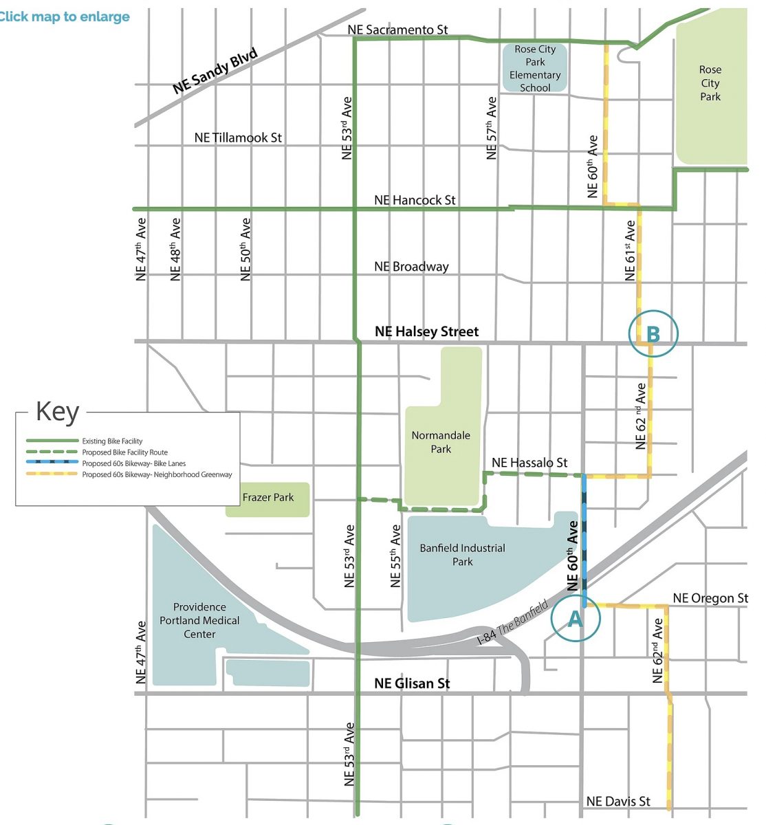
The bikeway proposed so far is in yellow and blue on the map below. It’s only on 60th for a few blocks and uses 62nd for most of the route…
The main goal of the NE 60th and Halsey Improvement Project is to get Halsey off PBOT’s High Crash Network list and update the outdated intersections at 47th, 57th and 60th. PBOT plans to reconfigure lanes and add new traffic signals that can synchronize traffic along the corridor. Another major component of the project will be the construction of wider sidewalk on 60th from the MAX Station (at I-84) to Halsey.
From a biking perspective, the big opportunity here is for bikeway improvements between NE Davis (in the south) and Sacramento (in the north). PBOT’s initial plan is to remove on-street parking and remove bike lanes on two blocks of 60th between the MAX Station and NE Hassalo. Unfortunately the current plan would drop the bike lanes north of that and divert bicycle users two blocks east to 62nd. The route would rejoin 60th six blocks later at NE Hancock.
Advertisement
Here’s how PBOT describes the bike-centric elements of the project:
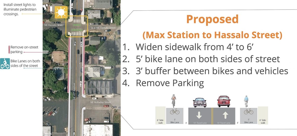
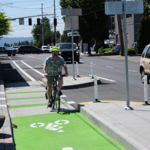
— NE 60th Ave from NE Hassalo to NE Oregon St: 5′-wide bike lanes with 3′-wide buffers to separate cyclists from the vehicle travel lane
— Portions of NE 60th Ave, 61st Ave and NE 62nd Ave: Sharrows, speed bumps, signage, and stop sign changes
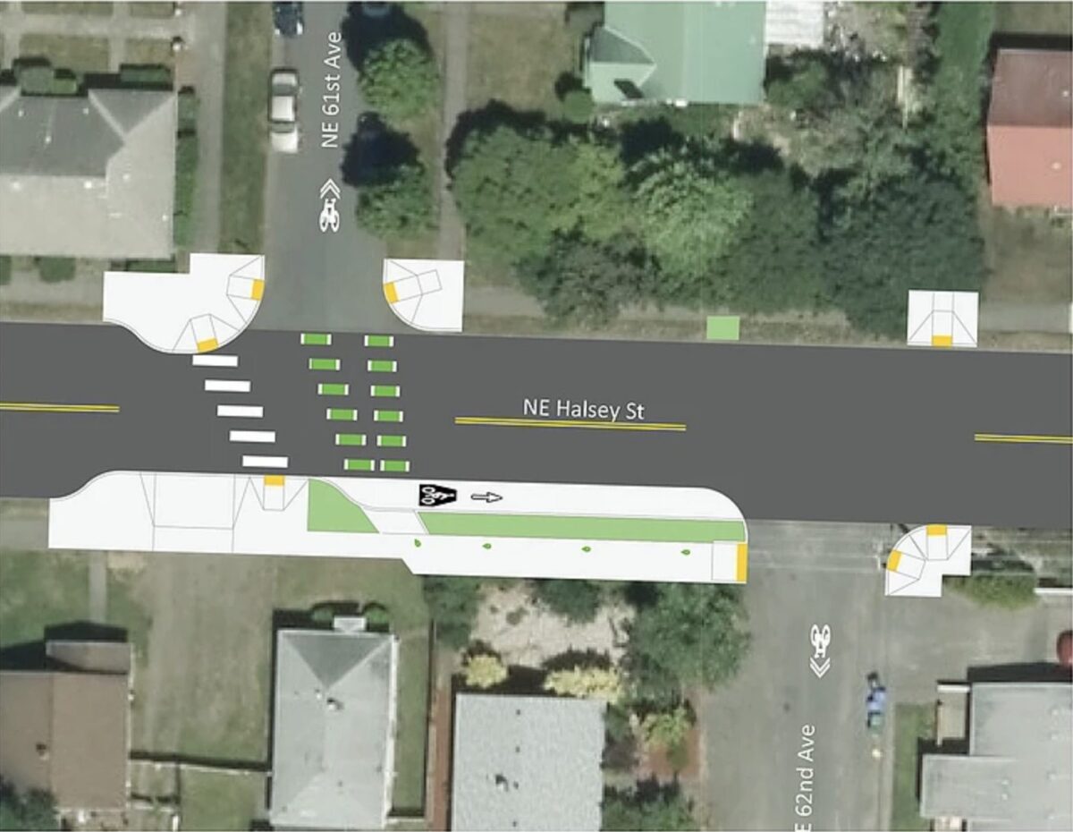
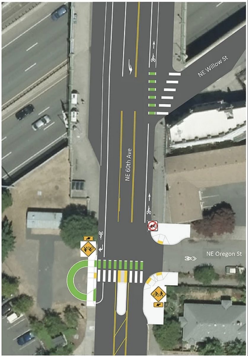
— New bike crossings, crosswalks, and curb extensions will be installed at two intersections: NE 60th Ave x NE Oregon St and NE Halsey x NE 61st /62nd Ave.
— On-street parking will be removed from both sides of NE 60th Ave from the south side of NE Hassalo St to NE Oregon St, and within 20’ on the approaches to each intersection along NE Halsey St, NE 60th Ave (south of Halsey), and the 60s Bikeway neighborhood greenway route.
— A new Bike Facility Route will be added to NE Hassalo St from NE 53rd Ave to NE 60th Ave. Improvements will include sharrows, speed bumps, signage, and stop sign changes.
Below is the proposed design of NE 60th crossing at NE Oregon:
And the new bike lanes proposed for 60th between the MAX station and Hassalo:
If you ride, work, or live in this area, please consider sharing your comments and concerns with PBOT via their online open house. They’ll accept comments through Monday, June 24th. Questions about the project can be directed to PBOT Project Manager Nicole Pierce via email nicole.peirce@portlandoregon.gov or (503) 823-6186.
— Jonathan Maus: (503) 706-8804, @jonathan_maus on Twitter and jonathan@bikeportland.org
Never miss a story. Sign-up for the daily BP Headlines email.
BikePortland needs your support.



Thanks for reading.
BikePortland has served this community with independent community journalism since 2005. We rely on subscriptions from readers like you to survive. Your financial support is vital in keeping this valuable resource alive and well.
Please subscribe today to strengthen and expand our work.
what if the twenties bikeway, but even worse
That jog on Halsey is confusing to me, looking at a birds-eye diagram.
Are they wanting northbound bike riders to cross southbound twice, while also watching traffic on Halsey and approaching the crossing from a counterintuitive direction (which means many people in cars won’t see them)?
Just like the one at 33rd and Going, or 86th and Division, planned for 86th and Powell, 54th(?) and Killingsworth. Kind of common, actually.
Less flippantly:
If PBOT is reconstructing sidewalks on NE 60th, why are they being built at 6′ wide? 9′ is the minimum for street trees (and even that’s not recommended by Portland’s Pedestrian Design Guidelines). 60th has a 50′ right-of-way, which means there’s room for 11′ sidewalks on both sides with parking remaining on one side of the street. Alternatively, there’s room for 9′ wide sidewalks and 6′ bike lanes, if parking was removed from both sides of the street.
Why does the bikeway jog so much? There are eight right angle turns between NE Hancock and NE Oregon, with significant out-of-direction travel. Good luck to the person trying to follow this route without the aid of a map. The most obvious solution would be to keep the bikeway on NE 60th with bike lanes south of Halsey, but even a bikeway that ran on NE 61st south of Halsey and 60th north of Halsey would involve fewer turns.
Why is NE Halsey being re-striped without bike lanes? There is a funded project to add bike lanes on Halsey east of 65th. This project locks in a big gap in bike network, that the 2030 bike plans says should be filled.
I live on NE 60th in the project area. The reason they are being built at 6′ wide is there is insufficient right-of-way on 60th. Ironically, some of the side streets have a wider public ROW than 60th. The current substandard (less than 4′) sidewalks weren’t always thus. Sometime in the past (likely the 1950’s or 1960’s), 60th was “widened” by removing the existing planting strip and cutting into the existing sidewalks. If you look closely, you can see remnants of what was probably a full 6′ sidewalk, now 3.5′ to 4′. If I understand the plan correctly, the sidewalks will be widened to 2′ by shrinking the portion of the currently roadway dedicated to cars. This will require no property acquisition/eminent domain/easements. But it also means no planting strip, curb-flush sidewalks, and no room for a future bike lane unless you eliminate parking on one side of the street (which personally I’m open to considering).
As for Halsey, I’m not a fan of the current plan. I think there must be a way to find dedicated space for bikes, at least on the uphill (eastbound) side. I intend to consult with the neighborhood association (to see what input, if any, led to the current proposal) and then file my comments to the city, either with or without neighborhood endorsement. In my opinion the parking on Halsey has been sparsely utilized (due to the pro-tem policy on weekdays) and the ROW would be better utilized by people on bikes.
NE 60th is a 50′ wide street, whereas our standard streets are 60′ wide. So yes, there’s less room to work with, but that doesn’t mean 6′ wide sidewalks should be acceptable. This is a street that provides a connection to a MAX station, so we should prioritizing pedestrians over car parking. Just by removing parking from one side of the street there would be room for 11′ wide sidewalks, with no property acquisition required.
Every time I see the plan for a bikeway I die a little on the inside because of the corners being cut in one way or another. In this case the constant jobbing required to keep bikes off 60th is impressive, no amount of wayfinding and directional sharrows is going to be enough to keep people on bikes reliable on this route.
In submitting feedback when the open house started, I made it clear that bike facilities need to be included on Halsey. As a High Crash Corridor with actual destinations it is imperative that people on bikes are able to safely access these businesses without having to ride on the sidewalk or take the lane with cars. This project could improve a lot yet is managing to avoid most of the difficult decisions in favor of leaving people on bikes completely out of the right-of-way.
Good lord, how illogical.
Just because PBOT foresees revolt from the Rose City Park NA if they propose parking removal (1- or 2-sided) on NE 60th between the MAX and Halsey doesn’t mean that they should preemptively fold. It’s the obvious way to route bikes here. It looks to me like every home on this stretch already has a driveway or adjacent side-street parking (corner homes).
This project was supposed to be primarily a bike and ped project for the MAX station area since it was significantly upzoned last year, but it looks like a big chunk of the project is going toward auto signals on Halsey. The City’s transportation system plan has a project description of:
“Implement pedestrian and bicycle improvements in the 60th Ave MAX Station Area identified in the Eastside MAX Station Area Communities Project.”
Maybe they combined them. Regardless, I’m curious what the breakdown in project costs is. I was involved in the Eastside MAX Station Area Communities project some 10 years ago and the vision was for a high quality walk environment on 60th and sidewalk infill around the station. You’d think $7.5 million (budget listed in the city’s transportation plan) would buy you more sidewalk and bike infrastructure than this. Seems disappointing that the only sidewalk improvements are a couple extra feet in width on a three block stretch while many of the side streets leading to 60th lack sidewalks altogether.
For the bikeway, it seems like a glaring omission to not include any bike treatments across NE Glisan at 62nd. There should be some sort of protected crossing there.
They are proposing a flashing beacon and diverter at Glisan. I’m arguing for an up hill climbing lane to get to Davis as well.
I looked again at the online open house and don’t see anything proposed for the bikeway crossing of Glisan at 62nd. Perhaps it was mentioned at a neighborhood meeting? Maybe it’s no longer on the table if it’s missing from the online open house?
I have been involved in this project since 2007 and was LUTC Chair for North Tabor Neighborhood to the south throughout the comprehensive plan, both of which the growing transit communities project was based on, which was adopted by city council. I can go into extreme detail of each step, and will.
I am leading a Pedalpalooza ride to show off the possible routes and talk engineering design. We will ride up and down Alameda Ridge several times, as well as loop south to Davis to show off the “Greenway Box” around the station. I will be relating the entire history of the project, missing connections and robust engineering solutions to each segment, as many of you know my rides can get a bit geeky. This one will be fun as it is in my backyard so to speak.
Both the project manager and lead planner for this project have stated that they will attend. This is the perfect opportunity to voice your concerns to them and help improve the project.
I posted on shift:
Maxing Access to the MAX: a 60s Adventure
Normandale Park, 5700 NE Halsey
Near the Restrooms
Mon, Jun 17, 2019, 5:00 PM, we will Pass the 60th MAX several times if you are running late
With three light rail lines the 60th MAX station could be an Amazing bike to Transit connection if only we had safe access. PBOT has money to build facilities, but their current choice is not world class in scope or safety. This ride will focus on what world class Vision Zero bike access could be, within reasonable budget constraints and city transportation policy. A technical ride with frequent stops for discussion, includes some steep slopes including Alameda Ridge and the northern leg of the Tabor Trail (60s Bikeway). 60s themed dress encouraged. PBOT comments and survey are open for comment until June 24. Terry D-M, the Greenway Guru
I just love the radical out-of-direction detours PBOT expects bike riders to use. I mean, seriously — they would NEVER expect car drivers to do this, why do they expect bike riders to? There is a much more direct way to connect NE 60th to NE 60th which doesn’t involve NE 62nd.
More half-baked meandering nothingness from PBOT which no one will use.
See: 20s and 50s bikeway
I live near 52nd and Glisan, so 50s is somewhat useful to me. This, aside from the improved connections to 60th MAX, will be useless.
As someone who lives 61st and Burnside, I can’t wait. The route north of the station needs work, plus there are missing connections east, west and south. Join me my ride June 17th!
OMG!…can someone in the pedestrian design realm work with PBoT / their consultant to tweak the pedestrian crossing designs shown…to make them more direct/ shorter and less oblique?! (I can see there are some conflicts on NE 61st but shifting the location of the ramp west on a longer bulb out can get the alignment better and help ned safety (less exposure to traffic). And how about the Willow crossing? Now the crossing oblique forces the ped to have their back to traffic turning right at speed…how about reclaiming that leg of the intersection (raised intersection? and adding a bit more “there” there vs. the 1950s highway “on-ramp” context?
Pretty stoked about this! This part of town is a big part of my life and each of these improvements has been on my my mental wishlist for a while. Turning left in any direction on 47th and Halsey is a horror and so is walking up 60th from the MAX. What a luxury to live someplace that pays attentions and answers to its citizens.
There is a monster hill on 60th south of Sacramento.
Used to go sledding there.
Wonder how many folks actually can ride it.
It’s a hill, but definitely doable. 61st Ave has the monster of hills – I’m afraid to even go down it because it curves and I’m on my brakes constantly.
Why does pbot keep drawing bike routes with squiggly pens?
Too small for good bike Lanes and good sidewalks? Should have made it a woonerf. Way to go Portland! Another super expensive half measure!
Dear Fellow Citizens and PBOT,
I live on NE 60th Ave near Bob. I support the eliminating parking on one side of 60th Ave (yes my side, West Side, of the street). PBOT said no.
Here is my official response to why I declined/abstained from voting at the LUTC meeting that took place on September 19th 2019. There was an immediacy of pressure to decide on a solution now; from both PBOT and the neighbors of ‘Snake Hill’.
Our statement as a Board should go back to both Commissioner Fish (Parks) and Commissioner Eudaly (Transportation), who at odds with each other in the media, as to why we can’t get PBOT and Parks to joint share projects for the first time since I can remember.
This project is a key example of the infighting hurting progress: On an accessible safe ramp option for bikes and people of all abilities in one of our oldest and loved parks.
I support the 3rd option, to delay this (there is NO immediate need) and talk to the parks department and put in a ramp. If the stairs at Rose City Park are not otherwise accessible, then we need to make it accessible. When did a residential street become an acceptable greenway?
When I do the math with this data
(source : https://www.portlandoregon.gov/transportation/article/490280)
PBOT is proposing spending a million dollars on 200 people to bike through here who are in-fighting with a few dozen homeowners. Over parking within 1/2 mile to a 3-train route MAX station. The best argument I have to make any decision who to support is in regards to safety. The proposal is not a safe solution. PBOT even said in our last meeting this is temporary solutions, and I do not support ANY expensive temporary solutions with my tax money.
We have a population of ~630,000 in Portland.
If the total is 6% of the population is biking during peak seasons, this is around 37,800 bicyclist. The number Portland likes to use is usually in the 40,000 – 50,000 range. Again, this is only during peak times of the year. (May – Oct, 6 months).
This connection project is accommodating .5% of the biking population during that peak season. It is not an immediate issue to fix. It is also accommodating the ablest bicyclists. So we are talking fractions upon fractions of people who want this option.
This is not the highest best use of our City government time or dollars.
We have 14,000 homeless who need toilets and showers.
Thanks for letting me weigh in.
Sincerely,
Michelle Neidiger
Rose City Park Neighborhood Associate Board Member, Environmental Chair
P.S. All are welcome and appreciated at our neighborhood committee and general meetings. Come say hello.
So many thoughts here that, while they make sense on their own and seem practical to the common citizen, represent pretty terrible policy.
Rather than breaking it down let’s just go with projects can be quite expensive or cheap and it is not related to the amount of usage. Saying that people aren’t biking so we shouldn’t invest in the network because there are better places to spend the money sounds great until you consider that it really means we should abandon bikes and focus on cars because pretty much everyone drives.
Our bike network will continue to underwhelm as long as it’s not actually a network. Networks are connected and bike infrastructure in Portland is not, there are many gaps and some of the reason for that is the cost associated with retrofitting certain areas so that it is safe for cars and bikes to coexist (this could be solved by eliminating cars from these stretches but that would require people to sacrifice which is a bridge too far).
A million dollars is a lot of money. We spend much more than that maintaining, and improving, roads for cars that pollute our air, kill our citizens, and make our transit unreliable through congestion. If you really care about the efficient use of “your” tax dollars perhaps we should stop spending them on roads that enable this kind of activity rather than trying to prevent low impact users from improvements in infrastructure that will make their trip safer.
Also a personal note and hello to maccoinnich who said to me, I don’t care what a bunch of privileged homeowners have to say so I won’t listen to you or attend neighborhood meetings.
Sir, you already have an entire forum, Next Portland.
If you comment frequently, please consider holding your thoughts so that others can step forward.
Regards,
Michelle Neidiger
I have absolutely no idea what this comment is about.
I can paste all your baiting, inaccurate, rude, and inappropriate comments here for reference, if you would like me to, Iain, but it appears you prefer your pseudonym name so I will spare you (And your employer) the embarrassment.
I have no idea who you are or why you are threatening me. I have no involvement with this project beyond having provided public comments.
Dear Nicole, PBOT,
Please reopen this discussion for comments.
Give us another 30 days for people to comment on the changes that were not proposed until August, and a month after the open house showed a different design plan. This forum was closed prior to that change, and the new changes should also have a 30 day comment period.
Thank you –
Sincerely,
Michelle Neidiger