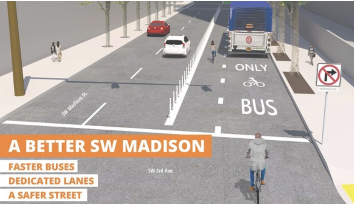
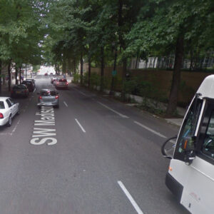
The Portland Bureau of Transportation announced the construction of its first Central City in Motion (CCIM) project today: SW Madison – one of the busiest bikeways in Portland — will get a dedicated bus operation and bicycling lane that will be separated from other traffic. The project aims to speed up bus trips, make it safer to ride a bike, and lower the the stress of drivers by giving them clear separation from other road users.
Portland City Council passed the CCIM plan back in November and this will be the first project from the plan to be implemented.
PBOT says the project should be completed over the weekend at a cost of just $160,000.
In addition to the new lane configuration, PBOT says the project includes, “a passing zone to help people on bikes bypass buses at stops and prohibits right turns onto SW 3rd Avenue to remove the risk of right hooks for people walking and biking.”
Advertisement
(TriMet video)
That last part is a very big deal. Almost seven years ago today, 28-year-old Kathryn Rickson was bicycling down Madison when a truck operator turned right at SW 3rd. The two collided and Rickson was killed.
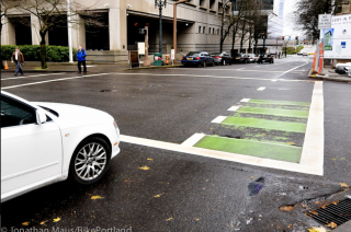
(Photo: J. Maus/BikePortland)
Another significant aspect of this project is that space for the new bus/bike only lane was made available because PBOT was able to use space currently used as on-street parking for Portland Police Bureau and other City of Portland vehicles.
Madison is not only a major bikeway, it handles more than 23,000 bus trips each day. Enhanced bus lanes are part of nine out of the 18 total CCIM projects.
When CCIM passed, there was broad skepticism about how long it would take to actually implement the projects. “We were serious when we promised a quick implementation of Central City in Motion,” said Transportation Commissioner Chloe Eudaly in an official statement released by PBOT.
In their announcement today, PBOT included a quote from Business for a Better Portland Executive Director Ashley Henry. “While employment in the Central City continues to grow, our streets aren’t getting any wider. This project is an excellent example of a rapid, thoughtful infrastructure improvement that can produce real benefits for area businesses by providing safer and more reliable trips through downtown for employees and customers.”
It’s notable that PBOT included a statement from BBPDX and not from the Portland Business Alliance.
This is great news! We are very excited to see progress and to see PBOT, Commissioner Eudaly, Portland Bus Lane project (a grassroots advocacy group that has worked on this project for years) and Business for a Better Portland come together and make this happen.
Onward!
—
Bonus: PBOT has also released details on the next two CCIM projects that will be built within 2019-2020: The Burnside Bus/Bike Lane Project and the NW Everett Bus Lane Project (which will be built this fall).
— Jonathan Maus: (503) 706-8804, @jonathan_maus on Twitter and jonathan@bikeportland.org
Never miss a story. Sign-up for the daily BP Headlines email.
BikePortland needs your support.



Thanks for reading.
BikePortland has served this community with independent community journalism since 2005. We rely on subscriptions from readers like you to survive. Your financial support is vital in keeping this valuable resource alive and well.
Please subscribe today to strengthen and expand our work.
Nice! I really like this design because it’s simple, straightforward, and predictable, unlike some of the “floating island” type setups where bikes/buses share space, and relatively easy to implement and cheap to build. Plastic bollards aren’t ideal, but better than painted buffers, and visibility is better when auto users are turning right vs. the Parking-on-the-left type curb arrangement. I’d like to see this as the go-to design for similar streets in the future, instead of the over-engineered stuff (e.g. NW 3rd just north of Burnside) with multiple crossovers etc.
I don’t think the experience of cycling in between buses and cars is great. I’ll do it, but many less confident cyclists won’t.
I think this project is great in terms of improving public transport, but not good at all for cycling. I’m okay with that, given that there are separate CCIM projects to provide protected bike lanes on the Salmon/Taylor couplet and the Jefferson/Columbia couplet. According to today’s release design work for the protected bike lane on SW Salmon is starting now, with the goal of construction in 2020-21.
In Madison (WI) there is a similar set-up, with a bike lane between a bus and general travel lane. https://goo.gl/maps/1mUawJy2MHdEFHZN7
It’s not horrible, because the lanes are very wide (and seemingly wider than what is proposed here), and people use it. But I also wouldn’t call it a low-stress/all ages, all abilities bike facility.
Regarding University Ave in Madison, what I’ve wondered (as someone who grew up in/near the city) why they didn’t just combine the lane with the curb-separated contraflow lane on the other side of the street. Only reasons I can think of why not is riders with origin and destination to the north would have to cross over twice, and the possibility of left-hooks (in the installed set up cars can/should merge across the bike lane before turning).
Not sure about the historical reasons for why the lane configuration is the way it is. Going to a two-way PBL on the south side of the street is something that the university is interested in as part of their master plan — of course as part of a project to increase motor vehicle capacity (https://fpmcpla.wiscweb.wisc.edu/wp-content/uploads/sites/20/2017/10/Appen-3-Long-Range-Transportation-Plan-2016-1019-low-res.pdf , page 67). And yes, the destination access on the north side is a big issue with that plan.
What a great change!
Glad to see this happening so quickly. They also announced the CCIM Working Group membership and there are many familiar faces. Hoping this is the first of many good things to come in the Central City.
Definitely an improvement and kudos to the bus lane project for their work on this.
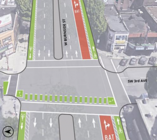
At the bridge entrance buses will need to cross the bike facility but the trimet video does not show how this be handled. Anyone know what’s planned?
The crossover I’m concerned about:
https://ibb.co/HdNRJHc
I’d like to see buses have priority but this would likely require some sort of signal upgrade.
Doesn’t that happen already now? Don’t bikes go around the buses when they pull over to stop there?
Yes, it does. This isn’t a change as far as that is concerned. https://goo.gl/maps/2g1KV5bniJxNyLkj7
“This isn’t a change as far as that is concerned.”
It’s also a major point of conflict on my daily commute. Is it too much to ask for this to be addressed in some way?
Your original post made it sound like you were unaware that this is an existing condition.
As I mentioned in a different reply I don’t think this is a very good design for bikes. I’m at peace with that only because I know other nearby streets, that extend further west than Madison does, will have better facilities for cyclists.
My concern was not “bikes” at all as I wrote up thread: “I’d like to see buses have priority but this would likely require some sort of signal upgrade.”
I see buses needlessly delayed here just about every commute.
Yeah… and it sometimes requires me to veer out into the adjacent traffic lane to avoid a bus that is pulling out. I’ve had more close calls at this one location than at any other location on my east-bound commute. In fact, I tend to ride in the adjacent traffic lane (when I can) because it gives bus drivers more opportunity to see me.
I understand that this project is largely a transit project but I often see buses have to wait as bikes and cars prevent egress from the bus stop. Addressing this bottleneck and conflict zone in a way that favors transit would be huge improvement, IMO.
From what I have seen of these types of implementations in other cities Portland will need automated photo enforcement for these facilities.
I’m pleased to see this happening, but I’m disappointed that even now as they are building out the first CCIM project, there don’t appear to be any actual drawings/diagrams on the PBOT project site to allow us to evaluate the details of the projects before they are constructed. On the SW Madison/Jefferson/Columbia project page (https://www.portlandoregon.gov/transportation/article/731989), there’s a link to an explanatory video, but that doesn’t even show the entire segment. (E.g. there’s no mention of what happens at Madison & 1st — will right turns be prohibited there as well?)
Also, there’s no mention of this on the project page, but the caption on the video indicates that the bus/bike-only lane will be created from 1st to *4th*. In other words, it won’t address the worst bottleneck for bikes along Madison, namely the bus stop at Madison and 4th.
This will be an improvement for bikes, in that it will eliminate a dangerous right-hook and the bus/bike crossover at 2nd, but it will be far from the benefit it could have been if it had been extended another block up to 5th. (Of course I would love for it to extend all the way up to Broadway, but that would require removal of curb extensions, which would greatly increase the cost.)
But the larger point, as noted at the top, is that PBOT is apparently holding their plans close. We need to be able to review and comment on the details of these projects before they are built.
OK, I see now that the Burnside and Everett projects do in fact have ‘concept drawings’ available on their project pages which allow you to see what the plan is. But nothing linked from the Madison page. And if they are installing this weekend, there are obviously detailed drawings available…
This is what I found: https://www.portlandoregon.gov/transportation/article/702665
All the conceptual designs are here: https://www.portlandoregon.gov/transportation/78066
I know one issue Portland Bus Lane Project ran into regarding the block between 5th and 4th was staging/temporary walkway for the Portland Building project. If that’s the case, the lane should be extended once they’re done with the space. In fact, it could even speed up traffic if traffic in the right lane is not able to get around stopped buses, not to mention providing clarity (and safety, etc) for bikes if there’s space for bikes to pass buses.
It should be noted that this project when even IMPROVE auto traffic, because the street essentially goes from 2 lanes to 3, with the buses being removed from the general traffic lanes. Also, it would have been nicer to have it back when Milwaukie-bound service also used the street.
This will be “just like” the Paris shared facility on Boulevard Saint-Germain (circa ~2002).
https://goo.gl/maps/8qDSbaJwvHD4jyVG6
2 Cents: I too hope PDoT finds a different method of hard delineation vs. wands. (Wands should only be used in parking lots…as they are not a long term solution w/o intensive maintenance.)
My point of view is that with the limited funds currently authorized, PBOT should use wands, planters, bales of hay, paint, or whatever else is quick, cheap, and easy to reallocate road space for buses and bikes. Once the buses start flowing freely, we will see a big increase in their popularity.
If the usage patterns change, then when it’s time to maintain/rebuild the roads, spending the money on concrete will be much easier politically.
Sure bales of hay and other off-the-shelf consumer items may have a lower initial price point (and their advantages in a tactical urbanism demo), but this many wands and their repeated maintenance by a public works crew will likely end up costing more that some strategic concrete. There are some better tools than wands … Honolulu is currently struggling with this issue on its first PBL. (To where the local “BTA” has to go our and glue down the fallen wands and push back the extruded asphalt curbing…)
https://goo.gl/maps/U4XBQhBVLzQoqYACA
The reason they use wands in my opinion is they don’t damage the cars that hit them that much. They don’t want to deal with the fallout from some drunk driving idiot plowing into a jersey barrier fast enough to kill themselves so they put in wands. Hopefully at some point they will get tired of replacing wands and make the switch to something that might actually slow a car down.
The wands on Lincoln St. at SE 42nd were run down so many times they had to replace the original install with wands with spring-loaded bases. They still get hit, but they seem to flex now, rather than just getting torn out. I think some skateboard grip tape around the tops of the wands might encourage drivers to make more of an effort to avoid them – wouldn’t hurt anyone, but would not be good for your paint, especially if you mow down the whole row of them.
I wonder what type of political lift it was to get PPB to give up those few cherry parking spots along Madison – and if that is what contributed to the high cost of this (paying to house those police cars in some private garage). $160,000 for 3 blocks of paint and plastic wands – what am I missing, here?
Labor. It’s expensive in Portland, but especially at PBOT. The cost would double if ODOT did it, but half if the city hired Gresham, and a quarter of the cost if some city in NC did it – but then our city of Greensboro would do it just slightly wrong, just enough to screw it all up.
This seems like an improvement for traffic flow, but I can’t help but think about the optics on combining bikes and buses. I understand that this is present elsewhere, but it seems so counter-intuitive where safety is concerned. As far as fears go for people who feel unsafe on bikes, usually being run over by a bus tops that list. But, as a hardened cyclist who is used to maneuvering around buses, alright! Progress, I guess. Less cars and no more right hooks! I’ll take it.
I think this is a great design — it’s simple and operationally obvious to everyone, and I think it will be a huge safety upgrade for cyclists and performance upgrade for transit. It will also be cheap to build, so if it works out, maybe we can get more.
Certified TriMet drivers are not like most ride-hail drivers.
If anyone is still confused as to how this will work, just look at the stretch from Madison and 10th to Madison and Grand. It’s going to be exactly like that with the addition of the bollards. Bus/bike lane to the right with bikes to the left of the buses. It’s much easier for us to see the bikes at our left than on the right, especially in the shade to sun area of question. The bike box at Madison and Grand gives priority to bikes at the light approaching the bridge. There will no longer be the sketchy crossover that took place between cars, buses and bikes that took place at Madison and 2nd. Trust me, as a TriMet operator, that was a spot that caused much stress during the commute hours.
I think it will be better than that stretch — aside from the wands, this will have a dedicated bike lane, not just a shared space. Riders will be able to pass buses when they are stopped without pulling into an adjacent traffic lane.
as if people will stop turning right onto SW 3rd Avenue, all the “no Right Turn” signs installed on 5th Ave certainly don’t stop right turns for s**t.
This is great, but I have little faith people will heed the signage until significant enforcement happens. The bus and bike only lane on NE Grand is completely ignored.
“more than 23,000 bus trips per day…” I think you mean 23,000 bus passengers, or boardings per day.
5th and 6th comprise a wrong way couplet: to enter and exit one must bear to the left, not the right; this causes mistaken motorists to seek the right lane, as they would on a normal couplet.
For some reason the original transit mall from the 1970s was designed this way.
Main and Madison are a normal couplet, so there is no subtle incentive to seek the right lane.
Great to see the CCIM projects finally coming online.
I’m in full support of building it out as fast as possible, with white plastic bollards and paint at first, then filling in with more substantial barriers.
If NE Broadway/Weidler had been built out sooner, there would not have been a pedestrian fatality there last month.
Early build can save lives.
Thanks, PBOT!
Ted Buehler
Where else is it designed for a bus to squish the person on the bike? Copenhagen design puts the rider on the right between the bus and the sidewalk. This design is also all over America. WTF is this abomination?
Where is this “squishing” happening? I see a bike lane that is always open, plus a bus lane that will usually be open. This looks like a great design to me — most of the time there will effectively be a 15ft bike lane; when a bus is present, it will operate like a normal bike lane, admittedly without the danger of being doored, and with some vertical elements to underscore the separation.
Absolutely agree. We’re all accustomed to going around buses at stops, and in this case we get a dedicated space to do so. And it doesn’t require the bus to move over into the bike lane at stops (“squish” hazard!), or alternatively bus islands that people here will complain about for being inadequate. It’s a great, simple design.
it’s also a design that will discourage many from cycling. i’m ok with that because i personally prioritize mass transit over cycling which it comes to our city’s transportation policy.
anybody ride on it yet? the wands that include the small plastic curb do seem slightly better than the wands only on, for example, Naito.
I’ll likely not use this lane, as I usually am only on Madison between 4th and 2nd, and I turn left on 2nd. I rode these two blocks this morning, and it was a bit strange to see the parking removed on the left side, but other than that, my commute is largely unaffected. The nice thing is that visibility into the park is much improved with the parking removed, and it actually lowers the stress level—not that it was that high to begin with. Something about having at least one direction to look in and not have cars, cars, cars—moving or parked—up in your face. Now that I think about it, it’s actually really calming. Of course, if I had driven downtown and was looking for a place to park, it would have the opposite effect…
Again, is this a nacto design or just some made up design half measure by pbot? Put another way, who will die first?