UPDATE: This post has been edited to reflect the fact that the State of Oregon has not technically “closed” the gorge to bicycling. People on bikes are still allowed to use I-84 (legally, from NE 238th east); but should be advised of work zone conditions. We regret any confusion the initial story caused.
The combination of fire clean-up and construction of new paths (ironically) adjacent I-84 has led to a decision to prohibit bicycling warnings for bicycle users through a key segment of the Columbia River Gorge this summer.
An Oregon State Parks employee emailed us about the news last night and urged us to spread the word so that no one gets stuck. “What I have found is there is no way to ride through the Gorge this year — not even for those willing to ride on the shoulder I-84.”
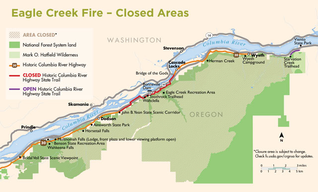
The Historic Highway State Trail route is open between Hood River and Mosier, but it’s currently prohibited not advised for bicycle riders to ride from Bridal Veil to Hood River.
Bicycle users who want to bike all the way through will have to should consider crossing the Columbia River and use Highway 14 on the Washington side as an alternate.
Advertisement
This is bad news for the many people who take the Lewis & Clark Trail route promoted by Adventure Cycling.
Crews are busy cleaning up the Historic Highway after the Eagle Creek Fire that decimated many acres last September. The usual route for cycling is to take a combination of the Historic Highway State Trail and a short stretch on the shoulder of I-84 where the final few miles of the State Trail are unfinished. The State Parks employee we heard from said construction of that new section from Wyeth to Lindsey Creek (due to open next year), “is causing shoulder and lane closures due to pavement work.”
Parks has posted a map and an update on their website with more information.
UPDATE: Here’s the official latest word from OPRD:
The Oregon Department of Transportation and Oregon Parks and Recreation Department are working to reopen the Historic Columbia River Highway State Trail as soon as possible. Interstate 84 through the Columbia River Gorge is open and bicyclists may ride on the freeway at their own risk. Another option is Highway 14 in Washington. Visit the Adventure Cycling Association website for a detailed map included with their Lewis & Clark Bicycle Trail route series.
— Jonathan Maus: (503) 706-8804, @jonathan_maus on Twitter and jonathan@bikeportland.org
Never miss a story. Sign-up for the daily BP Headlines email.
BikePortland needs your support.


Thanks for reading.
BikePortland has served this community with independent community journalism since 2005. We rely on subscriptions from readers like you to survive. Your financial support is vital in keeping this valuable resource alive and well.
Please subscribe today to strengthen and expand our work.
but surely we cannot live without more car lanes being planned for Oregon freeways
What a disappointment, the Gorge trail is so beautiful. I know they’ve said there’s no money in the budget now, but this would be a good opportunity, timing-wise, to do something about the stairs!
The Adventure Cycling L&C Route is also the route of the Trans-America Trail (USBR 76) thru the Gorge as well. The other alternate is likely US-20 between Ontario/Vale and the Coast.
Mike,
Actually the TransAmerica Bicycle Route does not go through the Gorge. It crosses into Oregon near the Brownlee Dam and Hells Canyon Recreation Area heading across the central part of the state through Sisters to Eugene and then north heading for Astoria.
USBR 76 has not yet been designated in Oregon.
Hopefully the outcome of this year’s Gorge closure will result in better conditions for the long-term.
Jennifer
Sorry folks, forgot to identify myself as Adventure Cycling Routes & Mapping staff on my response to Mike.
So, let’s do the math here.
No bicycles between Bridal Veil to Hood River. Bicycle users who want to bike all the way through will have to cross the Columbia River and use Highway 14 on the Washington side as an alternate.
Except that when you get to White Salmon, across the river from Hood River, you can’t cross that bridge. On foot, bike, or anything that’s not a motor vehicle. So, keep riding to the Dalles and circle back, I guess. I just thought that’s important to note in case anyone wants to try it.
As Pete points out below, WA-14 west of Bingen is a deadly nightmare. However, you can get across the Hood River bridge with a bike if you’re willing to call a cab and throw your bike in the trunk. That sucks in principle, but probably isn’t a big deal in practice for most people.
Seems unfair that the Washington folk with their fireworks mania burnt up the Oregon side of the gorge but left their side rideable. I guess the world is not fair.
If you want to call Highway 14 “rideable”. There are at least 5 tunnels where you have to take the lane, in the dark, among the speeding trucks, and the shoulders are virtually non-existent in places (particularly some of the hills where they’re most needed).
What a shame, hopefully they take advantage of the situation and get ahead on some of the reconnection segments. Would the Gorge shuttle be an option to bridge the gap between BVF and Hood River?
the headline is misleading… it sounds like just the historic highway and the I-85 shoulders will be closed…
you can still take the lane on that section of I-84…
so no, cycling is not closed off in the gorge… it’s just severely restricted to only the most brave…
Has anyone taken the lane on I-84… ever?
Yes. Back in the day we had to ride on the road and through the tunnel near Bonneville dam. You said your prayers and hoped for good luck. Oh yeah- we didn’t use lights back then either.
Ho-lee moly, that sounds horrible. I sincerely hope no one takes this advice.
There are some other great routes in NW Oregon. This summer seems like a great time to go explore some of them.
Yep, looks like a good year to ride somewhere else, at least for those with a choice in the matter.
Jonathan, did you contact ODOT to confirm this? I have reason to believe that the State Parks employee may not be fully aware of ODOT’s policy to maintain bicycle access through the area. I just called ODOT Communty Affairs, and Katelyn Jackson confirmed that even with construction, I-84 should be passable to people on bikes, even if it’s not the preferred route. Not ideal for people wanting a low-stress and car-free route through the Gorge, but for those willing to ride on the freeway, we should still be able to get through.
Still confused – are they closing off the I-84 shoulders? Why can’t you ride on I-84?
Exactly, my takeaway was that I84 was going to be reduced to a single travel lane EB even for vehicles in spots as it has been previous years around Starvation Creek and Shellrock Mtn. I am sure ODOT REALLY want’s to discourage mixing bike and vehicle traffic in the single lanes, and this time I agree with them. Taking the lane on lightly travelled roads and highways is one thing, but pulling into the lane at 15mph and expecting a 60mph truck to see in time to safely slow to that speeds way too much of gamble with your life.
There are several places where the shoulders are not rideable because they’re blocked for construction of both the bike trail as well as seismic retrofit completions on the remaining overpasses (been in process a few years now).
Even when the shoulders are “open”, the rumble strips and chipseal make it a beeatch…
It’s good to hear from you, JR.
Supporting what you wrote, from the Oregonstateparks.org link that Jonathan included:
The “Wyeth [Campground] to Lindsey Creek” segment mentioned by the OSP person is the infamous Shellrock Mountain part, only a few miles long but fast MV traffic, narrow shoulder with drain grates, short sight-lines, a wall on the right, and debris fall possible even before the fire. A lane closure there will slow (and crowd) MV traffic into the left lane. If ODOT put a cone line down the center lane stripe and left enough room for bikes on the right of the cone line – left of construction equipment – it could be oddly nicer than the shoulder is now. I don’t know why or if the westbound lanes would be affected, except for gawkers.
How about closing reducing the number of automotive lanes on I-84 to allow bikes to continue. The kids who started the fire were trying to use an automobile to escape, not a bicycle. Yet bicyclists seem to be the ones who are getting punished for this.
I think lanes are reduced in the area that they are referencing the work. Instead of two lanes and a shoulder, they have it closed down to a single lane – at least that’s what I’ve experienced driving out to Hood River a few times this month. The pinch point means that vehicle speeds drop quite a bit through this area so you *could* take the lane, as suggested above, but it would still be pretty dicey if you were riding during a less congested/more free-flow time.
oh just stop. sure, that stupid kid started the Gorge fire to punish you personally. get over yourself.
Oh PLEASE! That is completely unreasonable. Limiting traffic on a MAJOR national freeway (meant for motorized vehicles) so that bikes can use a road that we seldom would (and probably shouldn’t) for obvious safety reasons. Gimme a break! … and I’m an avid road cyclist, by the way… not some strictly motorized vehicle driver with a vendetta against cyclists.
Interesting that the historic highway sections that cars drive on are still open. It looks like it’s just the bike-only trail that is closed. If the work is so critical, why are there no impacts on HWY 30?
Additionally, is this work occurring all week, including weekends? Why aren’t they considering weekday only closures?
No the long section of the historic highway between Bridal Veil and where the trail starts past Ainsworth SP is closed to cars, bikes and peds. Must. Falls is accessible only from the freeway lot.
Highway 30 merges with 84 in that section. That’s why the state trail is such a crucial link for cyclists.
I have toured the closed area. Rock fall is an ongoing hazard. Gouges like potholes are common throughout the closed area from rocks from bowling ball to washing machine size. Rockfall does not take the weekend off. As the weather dries, that change will loosen more rocks. ODOT is not making this up to punish gorge lovers
I think you would be ok on the weekend..
did a ride back on 10/07 took I84 to John B Yeon..and hopped on the trail there, hopped off after Eagle creek (there was a lot of rocks and down trees) had to walk a few little sections, but it was a do able..
They had some tape up, we just went under/over it no body gave us a second look.
See Granpa’s post above. I know it’s easy to get bureaucracy fatigue, but sometimes that tape is actually there for a reason.
HWY 14 is worse than taking the lane on I-84. Long sections of Hwy 14 have 12 inches or less of shoulder and it has heavy truck traffic between Stevenson and MaryHill. I have been on both and will never do Hwy 14 again.
This is from a biker who has biked on 6 of the seven continents, and lives in Hood River
Does anyone know if ODOT has posted a detour / diversion signage and stencilling (orange sharrows anyone?) plan ?…and if it went through their BPAC committee for comments?
UPDATE: This post has been edited to reflect the fact that the State of Oregon has not technically “closed” the gorge to bicycling. People on bikes are still allowed to use I-84 (legally, from NE 238th east); but should be advised of work zone conditions. We regret any confusion the initial story caused.
Here’s the official latest word from OPRD:
Thanks for the update, but I’m still confused. This part still needs clarification:
According to the OS Parks map in this article, it looks like Highway 30 remains open from about Warrendale on to points west (Vista House, Corbett, etc), and from Cascade Locks east to Wyeth State Park, where it ended anyway. Those parts are also open to motor vehicles.
The closed section is the non-motorized John B. Yeon trail from Warrendale to Cascade Locks. That is the same “Emergency Closure” which has been in effect since 09/23/2017:
https://oregonstateparks.org/index.cfm?do=parkPage.dsp_parkPage&parkId=114
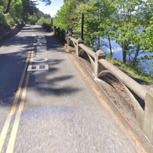
I-84 remains open to bikes east of Wood Village (though why anyone would not stay on surface streets until Troutdale is a mystery to me), period. The pinch-point, though, is worse than the Shellrock Mountain section. This section has the Toothrock Tunnel mentioned above by “highrider”: https://goo.gl/maps/6mBBCP2NKMQ2 (streetview of tunnel entrance). Side-by-side 60mph semis is not going to happen to me in that tunnel. The rest of the Warrendale to Cascade Locks section of I-84 I would consider riding, but the tunnel is a “no go” for me.
Are those accurate assessments of the route? Is there any other way to get by Toothrock by bike?
ODOT’s official position pretty much seems to be “bicycling is not advised.”
You need look no further than ODOT’s demand that bike lanes on 26th Avenue, a city street, be removed. ODOT’s “compromise” is stripe it narrower and call it a shoulder and remove the bike box.
I believe that is incorrect. While Google maps with traffic info showing doesn’t show a complete closure, it does show a full closure of 30/HCRH just east of Bridal Veil (I84 exit 28) and another closure at Exit 35 at Dodson just east of Ainsworth SP, thus closing 30/HCTH to all access between those points. Oddly the frontage road through Dodson to John B Yeon trailhead does look open, but then the trail section is closed.
I believe from Cascade Locks it should be fine, from studying fire maps I do not believe the fire came all the way down to Herman Creek Rd. I think the transmission line break S. of the road stopped the fire advance for the most part. So I think you should be able to go E from Cascade locks without FIRE related problems. I think though that E. of Wyeth is where it is construction shoulder and right lane closures that would be the impediment, and where you would have to merge in to the one open (left) lane of the freeway.
^ reply to Alen 1.0, not OP
Oh yeah, thanks, I had not flipped on Google’s traffic overlay. So, maps.google does not align with the OS Parks map about closures on HCRH-30.
Maps.google shows a road block on HCRH-30 just east of Bridal Veil Falls, but the road doesn’t indicate closure (no red dashes). The full closure appears to begin at Multnomah Falls and continue east to Ainsworth SP/Exit 35. From there, HCRH-30 looks like it’s open up to the John B. Yeon trailhead. I wonder about bikes on that section from Bridal Veil to Multnomah?
I was riding out to Mulnoma Falls on HCRH this weekend and was not allowed to go beyond the intersection at E Bridal Veil Rd.
No Bridge of the Gods this year. Hwy 14 is not that bad, unless you count the headwinds around Bonneville. Big shoulder for that stretch too.