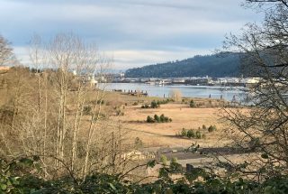
(Photo: J. Maus/BikePortland)
Earlier this month we shared a rare update in the status of the North Portland Greenway Trail — a project that’s been in the works for over a decade.
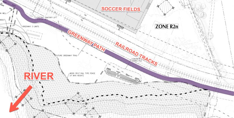
The University of Portland’s Franz Campus expansion was heralded as a huge step forward that will develop 35 acres of shoreline property on the Willamette riverfront. The new campus includes several new buildings, sports fields, a dock, and surface parking lots. But what it didn’t appear to include was space set-aside for the NP Greenway path.
Asstistant Vice President for Community Relations & Special Projects at University of Portland Jim Kuffner provided us with a statement that said he only planned to offer 8-feet for the path and that, “The land to complete the trail must come from Union Pacific.”
That statement — and publicly available renderings of the Franz Campus that didn’t clearly show where the path would be located — made advocates for the project understandably nervous.
Now I’m happy to report that tensions have eased and the path is alive and well.
Reached via phone last week, Kuffner sheepishly acknowledge, “This was a misunderstanding and I believe this is a kerfluffle we’ll blow right past.” Kuffner, who’s now semi-retired and is a well-known liaison between the university and local neighborhood groups (he’s even hosted meetings on campus with NPGreenway, the non-profit group dedicated to building the path), has been intimately involved in this parcel of land for many years. Dealing with the overlapping bureacracies that come with a piece of land that’s a century-old Union Pacific Railroad (UPRR) easement and bordering an EPA superfund site can get a bit complicated.
Throughout the university’s negotiations on the parcel, Kuffner said, “We’ve always been paying attention to the needs of the NP Greenway trail.”
Kuffner explained that UPRR was granted a 200-foot wide easement (100 feet on each side of the track) in 1901 in case they wanted to add another track. When the university bought the property in 2009 they became owners of the entire parcel — minus that 200-foot right of way. But since over 100 years had passed and UPRR had never expanded their operations (even the one track today is infrequently used), the university was able to successfully negotiate ownership of half that old easement. This is where it gets with property lines, buildable areas and easement rights.
Advertisement
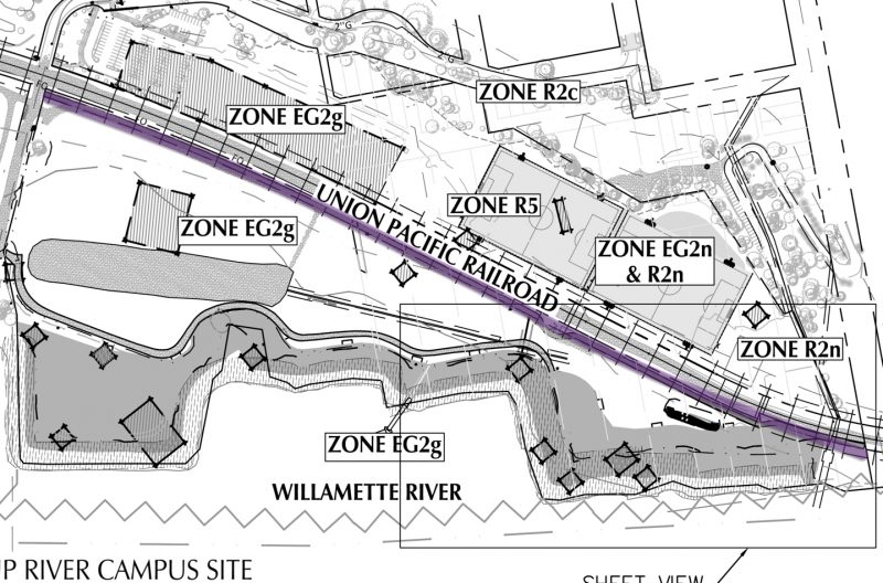
The bottom line is this: Kuffner simply misstated how much land the university already owned. It turns out they have enough room for the greenway without needing to seek permission from UPRR at all.
“We are 100 percent committed to building the trail,” Kuffner emphasized in our phone call last week.
But we might not be out of the woods with this issue just yet. It’s important to keep in mind that the right-of-way being set-aside for the greenway, which would ideally be part of a regional path network and a public facility, is owned by a private entity.
Kuffner made it clear that UPRR could still opt to exercise their existing easement and add a second track. They haven’t chosen to do that for over 100 years, and it’s highly unlikely they’d do it, but technically they could. University of Portland is comfortable with the risk; but how would the City of Portland feel about putting a public path on a private easement?
And much like a section of the Springwater path built in 2011 when a new development went in, this greenway won’t connect to anything (other than the university campus).
“Although we think this is a great opportunity to demonstrate to others that we did this and you can do this too,” Kuffner shared, about building the greenway, “We’re a little concerned that people will come down and realize they really don’t have any other place to go.”
He’s right when it comes to using the path for commuting or other through-trips; but at 2,000 feet and with other activities going on at the future Franz Campus, I have a feeling the path will still be popular for rolling and running.
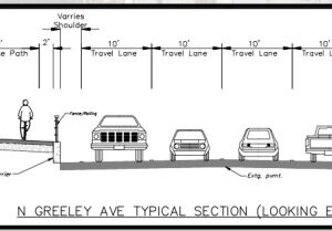
Kuffner says the plan drawings currently show the “Future Greenway Trail” at 12-feet wide with a two-foot shoulder on each side for a total width of 16-feet. There’s also likely to be an additional 3-5 foot planting strip between the path and the railroad tracks. “This should enable UP to provide a very comfortable and safe segment of the NP Greenway Trail for all future users.”
The university is still going through a full Greenway Review process with the City of Portland and we’ll get more details about it later this spring or early summer.
— Jonathan Maus: (503) 706-8804, @jonathan_maus on Twitter and jonathan@bikeportland.org
Never miss a story. Sign-up for the daily BP Headlines email.
BikePortland needs your support.


Thanks for reading.
BikePortland has served this community with independent community journalism since 2005. We rely on subscriptions from readers like you to survive. Your financial support is vital in keeping this valuable resource alive and well.
Please subscribe today to strengthen and expand our work.
This is great news! But I must say I’m left still very confused. So there was a 100′ easement on either side of the track. UP acquired half, which I take to mean 100′ on one side of the track. And I take it to mean the path will be in the half that is still subject to easement.
But the project (the UP facilities) looks to be well within 100′ (and even 50′) on both sides of the track. Surely they’re not building at risk. So what am I missing here?
Another bureaucratic SNAFU melts away under the withering spotlight of justice shined down by Bike Portland
If the public can access the trail via VanHouten or Porstmouth, there are pretty accessible trails north of the RR bridge that lead to former steel yard, just a few hundred feet south of Cathedral Park. Unless they work very hard at blocking this off, there ill be pretty good access from UP to Cathedral Park, which is great news!
I love the increased connectively, but sadly fear the end of urban dirt riding down there. Its ironic that asphalt paths replace every natural surface opportunity for riding. Soon all of Portland will be asphalt.
I am relieved to hear this news.UofP never was in opposition to the trail,to my knowledge. It has been a long process and ‘slippage’ and miscommunication are inevitable over time. The biggest challenge to the trail lies not in the University, but rather the other UP in the mix: Union Pacific Railroad. Access near, through or around the Albina Yards and the bluff can only happen if UPRR finds it in their interest to allow it. from the bluff to Kelly Point are only a matter of time. From the bluff to the Steel Bridge is where the energy and fight lie.This is not the npGreenway Trail. npGreenway is a citizens group formed to ‘make’ the City get this long envisioned North Willamette Greenway Trail a reality. Part of the original 40 mile loop, it should have happened a long time ago. Engaging with npGreenway.org to give their efforts a boost seem the most logical way to show support and give it wings. I was involved for nearly a decade, but like many , age and health dictates more than heart. Get involved in this, and any other trail you deem worthy. They are all investments in the future.
I have to say references to “UP” in a story concerning University of Portland and Union Pacific is very confusing!
i agree! I’ll change it to “university”
And in an article about “What’s Up with UP and UP and the MUP?” at that. At least UP said yup.
Phooey… I didn’t even make it half way…
I think it is highly unlikely that Union Pacific will ever duplicate the line, so I think the MUP will be safe indefinitely.
As long as good trees as planted !
i’m confused about access to the path: based on the sketches, it’s on the south side of the RR tracks, the opposite side from the university and closer to the river. i walk around this place all the time since i live right by the St Johns Bridge, and while i notice a massive pile of dirt that’s now been loaded to the site, i still can’t figure out access to the new path and/vs location of the site and needing to cross the tracks.
This is great news and could well be a catalyst for the entire northern section of the Willamette Greenway Trail. Done right this segment can be key link within U of P’s new campus, as well as an important piece of the future trail. Maybe the UPRR can offer a few feet of its ROW for more landscape screening too.
But looking down the road or trail, to the north lies lots of exciting possibilities…and soon realities.
1. McCormick/Baxter superfund site is effectively owned by DEQ after its $40M clean up, despite the claims of the former owners. Decades of contamination have been separated from the River by a barrier and covered, so the land cannot be used for housing, but it might work out to become part of U of P’s River campus, and that would extend the WGT to the BNSF line. Fingers crossed!
2. The next portion of land to the north, Willamette Cove, is owned by Metro and should be seeing the final stages of an environmental cleanup. Metro has bond $ for building that section of WGT; the question is does it have the will? Need to keep the heat on!
3. Lampros Steel property will include the WGT if it is re-developed as anything other than industrial uses, regardless of ownership. That gets us to the BES Water Lab with a short section a lovely waterside Trail into Cathedral Park. Easement talks on ongoing.
4. Between there and Pier Park, Portland Parks has a proposal for the WGT through the Baltimore Woods and via public streets; its Metro grant application should do better next round when its application includes the WGT’s potential as a “last mile” link to two Frequent Service and four other bus lines.
5. Now things get exciting…a key bridge now links Pier Park to Chimney Park over a busy RR cut, and Metro has the money in hand to extend the Trail on a bridge over Columbia Blvd into the St Johns Prairie (formerly landfill, now being restored) to a view point looking over Smith & Bybee Lakes. Metro intends to do the necessary preliminary work on a needed bridge over the North Slough to get to an existing, but substandard, trail section from there to Marine Dr. and Kelley Point Park.
If luck holds this could all happen in my lifetime! Going south around the Bluff, through Swan Island and around the UPRR’s Albina Yards is another story.
IDK… another wild space ruined by taiming it, riding Springwater on the Wilamette was sooo much better when you had to ride next to the ballast of the rr trax & no body out for an aimlessly meander on the path. Gateway Green.. everywhere is better when you “aren’t supposed to go there”.
As Portland becomes more & more crowded, the lack of urban wild spaces will become more noticable.
meh becoming a hermit 100miles from the nearest person sounds better & better all the time & yet, more & more unlikely.