Oregon’s latest officially designated Scenic Bikeway traverses a rugged river canyon about 35 miles northeast of Bend and boasts a base camp at one of the coolest country towns in the state.
The Crooked River Canyon Scenic Bikeway is an 18-mile stretch of choice pavement between Prineville and the Big Bend Campground. The Oregon Parks and Recreation Department and Travel Oregon announced the route yesterday. It’s the 17th Scenic Bikeway in the collection.
Here’s more from the official description:
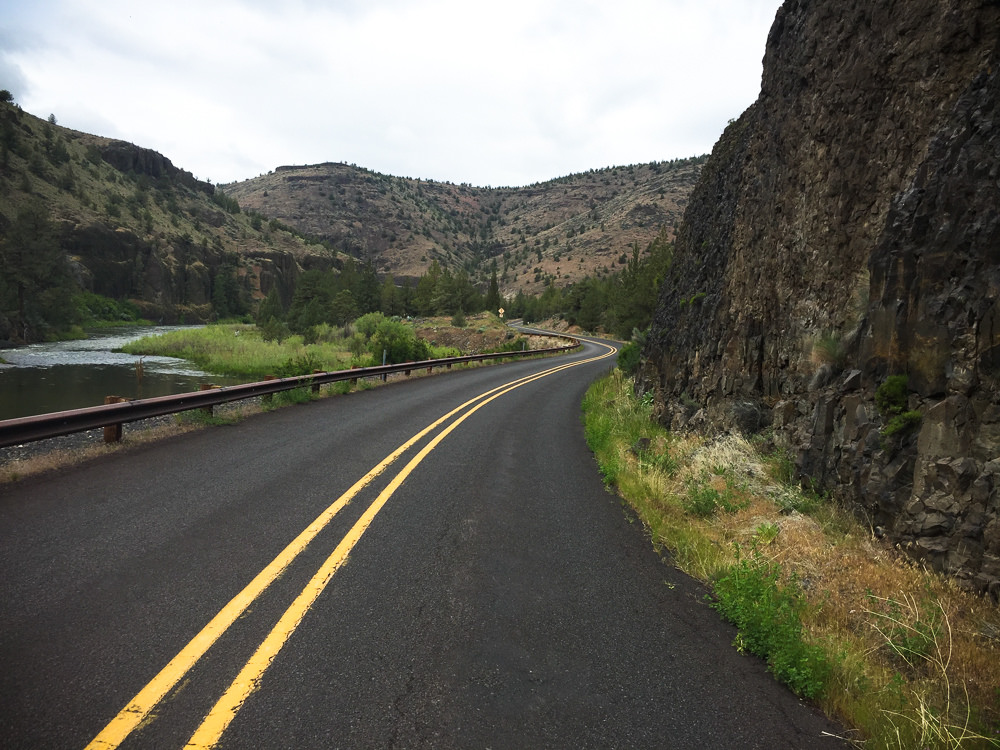
The route leaves the pastures behind as it enters the Crooked River Canyon. The road slips through the canyon’s towering basalt cliffs, gently curving and climbing to a scenic view near Palisades Campground before descending back toward the river. Riders will pedal by Chimney Rock Recreation Site, a popular picnicking spot and fun place to watch local anglers fly fish in the Crooked River.
The final stretch of the Crooked River Scenic Bikeway continues through the canyon and passes by several other day-use sites and campgrounds. Observant riders might spot resident wildlife like deer, great blue herons and golden eagles. The bikeway ends at Big Bend Campground, which has parking, restrooms, water and power.
Advertisement
The ride is best enjoyed during the spring and fall when seasonal colors are vibrant. Most of the day-use sites along the route have restrooms; two have water to refill any empty bottles. The bikeway can also be ridden on clear winter days, rewarding intrepid cyclists with brisk blue-sky rides through the quiet landscape.
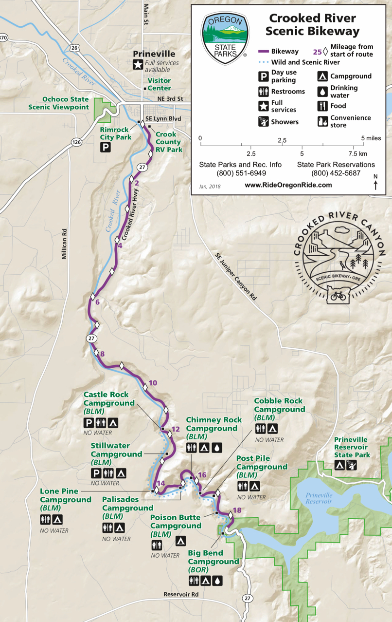
Here’s the official map:
Riders who have tackled the Oregon Outback will know this lonely stretch of Highway 27 well. I recall stopping for a few photos of the river and wildflowers along the road just past Prineville Reservoir when I did the ride back in 2015.
Highlights of this route include Prineville itself — a perfect place to hang out pre or post-ride. Don’t miss Good Bike Co. for friendly tips and last-minute items, or Connelly’s Cowboy Corner grocery store and deli to load up on snacks.
For a detailed description of the route and all the maps and other info you need for a great trip, check out the route on RideWithGPS.com.
Read more about Oregon’s Scenic Bikeways in our archives.
— Jonathan Maus: (503) 706-8804, @jonathan_maus on Twitter and jonathan@bikeportland.org
Never miss a story. Sign-up for the daily BP Headlines email.
BikePortland needs your support.


Thanks for reading.
BikePortland has served this community with independent community journalism since 2005. We rely on subscriptions from readers like you to survive. Your financial support is vital in keeping this valuable resource alive and well.
Please subscribe today to strengthen and expand our work.
Should the State really be promoting cycling on rural highways with no shoulders? I road the Highway 66 scenic bikeway out of Ashland. No shoulders. Lots of trucks pulling boats. Kind of nightmare. Don’t want to do that again.
Lipstick does not transform a pig into a movie star. Is there anything more substantial than words that makes this highway a bikeway?
I’ve biked (once, never again) and boated (many times) this stretch of the Crooked while living in Bend 20 years ago. During spring (fishing), summer (partying), and fall (hunting) you gotta be on alert for local rednecks who use the campgrounds for drinking bouts, family feuds and gun practice. And they all have barking dogs. Weekends are worse. Beware.
Then again, maybe things have changed with the influx of those massive data centers in Prineville and the people they brought with them.
Congrats to the folks from BLM, Crook County, Prineville residents, businesses, and others who have worked the past two years to make this route a reality. Thank you for sharing this local treasure with all Oregonians, and with those travelling from even further afield.
Does anyone know if this bike tourism work has included adding any bike repair/ fix it stations to the campgrounds or other stops?
Anyone riding in the country brings repair stuff, or should. The typical bike fixit station won’t make any difference.
Travel Oregon needs to work with ODOT on “developing” more friendly (bike safe) rural roadway striping configurations for sections without shoulders…such as lower posted speeds + removing the centerline for a middle bi-directional shared lane with two advisory bike lanes/ walking shoulders…as is common in Europe etc.
http://www.ktvz.com/news/crook-county-plans-juniper-canyon-road-improvements/653541538
How much will it cost to add 20′ paved width to hundreds of miles of rural roads?
It’s a lovely stretch of road and Prineville was very welcoming when to my friends and i when we rode through there with Whiskey and Wheelies a few years ago.
It really left an impression to me, excellent river access, bring your fly rod, but the canyon is spectacular as well.
It’s a bike route because it’s so beautiful, this road can’t really be improved, it’s a miracle there’s a road at all. It has to be seen, I can’t describe it well, the canyon walls are a steep as Smith Rocks faces. It’s like a Road Runner Cartoon.
This route would be spectacular if it could be closed to vehicles for, say, four or five hours for a Sunday Parkways style walk-run-ride event.
Thanks for the link to RideWithGPS. I suggest they consider publishing max and average grades on these maps, if not profiles. While I’m personally a huge fan of climbing on my single, I’m also looking for flat/rolling scenic routes for tandem touring.
Pete, They do. The profile is below the map on the right. For more information about the route click on the “Standard View” link under “Actions” near the top of the page. Then click on “Metrics” on the right of the page. Max Grade 6.8%, average grade 0.2%.
Sorry Pete. You meant on the Scenic Byway Map didn’t you, Good idea.