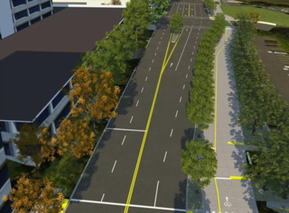
As I shared last week, the Portland Bureau of Transportation is about to launch a major project on SW Naito that will have a dramatic impact for bicycling connectivity downtown. The big open house is tonight (1/10) and there’s a lot of buzz around it already (Better Block PDX is making it their monthly meeting).
The star attraction at the open house will be concept drawings that give us a clearer view of what PBOT envisions for the new SW Naito. I haven’t seen all of the drawings yet (I don’t want to scoop the open house because that might discourage people from attending, although I will share them here as soon as they’re available), but PBOT has leaked a few of them out in the past few days.
Check out the plans for the new crossing of Naito at Jefferson, just south of the Hawthorne Bridge:
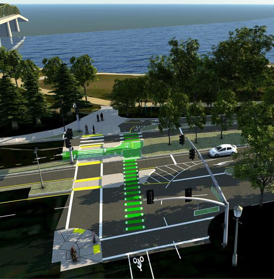
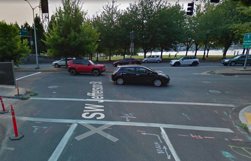
Compare that with the current conditions at Jefferson and you can see why this project is such a big deal:
Advertisement
This is the view from the road about two blocks south of the Hawthorne Bridge:
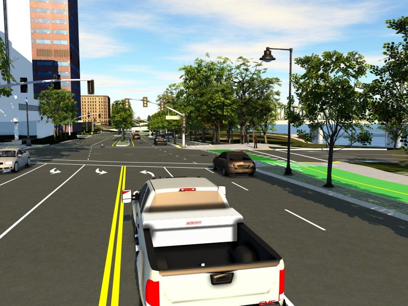
And here’s PBOT’s rendering of how the new bikeway will look south of Market:
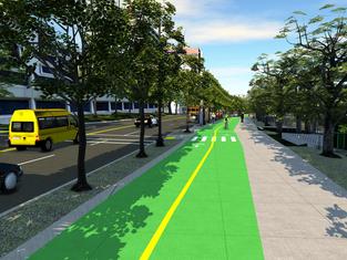
PBOT is calling this “a major facelift”. Naito will be, “completely rebuilt from the ground up, with safety and efficiency improvements for all travel modes,” from I-405 to just north of Jefferson. Other elements of the project are (via PBOT):
➤ New traffic signals, including a dedicated signal for vehicles accessing the Hawthorne Bridge and a pedestrian crossing signal to access Pettygrove Park, the Lovejoy Fountain, and the Halprin Blocks.
➤ New bicycle and pedestrian facilities on the east side of the street, including a new path and sidewalk. Currently, no bicycle or pedestrian facilities exist on the east side of SW Naito.
➤ Updated signal timing to improve traffic operations through the corridor.
➤ Improved crossings at major intersections to improve safety.
In an email from PBOT this morning, I also noticed an explicit mention of how this project is connected to Better Naito north of the Hawthorne Bridge: “The project’s boundaries end just beyond SW Jefferson, allowing a future connection to the seasonal Better Naito project and year-round access to Waterfront Park” (it should only be a matter of time before we can stop calling it “seasonal”). Combine this with PBOT’s recent completion of a new bike signal and protected bike lane from NE Davis to the Steel Bridge and we’ll soon have a protected bikeway for the entire length of Waterfront Park. (Sidenote: It’s clear that PBOT is doing whatever they can to surround the middle “Better Naito” portion with protected bikeways in order to bulk up their argument for making it permanent.)
Suffice it to say this could be a transformative project — and even though PBOT is already at 60% design, there’s likely to be pressure to compromise the design. Some changes are to be expected, but we simply can’t afford to make this a good bikeway when it has potential to be great. Please stay informed and ready to help PBOT do this right as the project moves through the public/political process.
Tonight’s open house will have free snacks and it’s open from 4:30 to 7:00 at the PSU Center for Executive Professional Education at 1500 SW 1st Ave., Suite 100. Facebook event link and more details on the BP Calendar.
— Jonathan Maus: (503) 706-8804, @jonathan_maus on Twitter and jonathan@bikeportland.org
Never miss a story. Sign-up for the daily BP Headlines email.
BikePortland needs your support.


Thanks for reading.
BikePortland has served this community with independent community journalism since 2005. We rely on subscriptions from readers like you to survive. Your financial support is vital in keeping this valuable resource alive and well.
Please subscribe today to strengthen and expand our work.
“there’s likely to be pressure to compromise the design”
I wonder if this is how things go in places we look to with envy? And if not, why not?
Because they have leaders with vision. When someone has a strong vision, convined with the willpower to make it a reality, anything is possible!
*combined
Oh, you mean like the Swedish version of ODOT coming up with Vision Zero, and bringing their legislature on board?
🙂
The myth of vision.
can you explain?
See: Janette Sadik-Khan, Mayor Bloomberg, and NYC
I generally like the road diet at SW Jefferson Street. Just plant a native White Oak tree in that new space at Jefferson at Naito. I’m excited about the smooth pavement.
I love this. Such a huge improvement over the current conditions. I am a little concerned about having a two-way bikeway crossing what’s basically a highway off-ramp tho. Is that safe?
But it operates that way today for all intents and purposes. This is the intersection during my daily commute where I am most on guard that a driver will hook me, even while traveling in a crosswalk with a walk sign. I learned the hard way that the middle lane in that off-ramp is both a straight and right-turn lane. While I anticipate those in the far right lane may not look for me/will turn right across me as I’m taking the crosswalk, it wasn’t until the someone in the middle lane accelerated into the crosswalk on their red light that I learned they might also be blindly turning right.
I’m betting the new configuration has a no-right on red. It should. At the very least all that new bike infrastructure/green paint should clue folks in that bikes will be crossing in front of you to access the trail when you have a red light!!
I’ve never seen a single driver obey a no turn on right sign. But hopefully they do put some thought into how to alert the drivers to look both ways. I agree that even the green paint alone is a huge improvement and will no doubt do a lot to clue them in to look. I’m not sure I even give a good enough look to bike/ped traffic coming from my right when I’m getting off here to get onto the bridge. I’ll have to be mindful of that in the future.
I have. Me! Every time I see one of those signs.
Does this new configuration leave Naito the same width as before, putting the bike path in what was formerly parkland, or are they proposing that Naito be narrowed to support the bike lanes north of Hawthorne?
A little from column A, a little from column B.
Pic 2 — Looks like the southbound bike lane needs additional width in that squiggle, so southbound traffic splitting to turn right or left doesn’t block each other up.
Also a larger radius on the turns would be really nice for people with bakfiets or trailers, but looks like space is tight…
Ted Buehler
How will the bike path remain a bike path, and not be a pedestrian zone where cyclists have to weave slowly through the crowd, like on the path by the riverfront?
Naito is an important commute route and needs to accommodate both drivers and cyclists moving at commutish speeds. For cyclists, that means we need to be able to ride at 15-25 mph without endangering ourselves or others.
Fortunately, the number of peds in this area is generally low even in good weather until you get to the park and the road situation is often a parking lot at rush hour encouraging cyclists to take the sidewalk.
I’m guessing a few places get gummed up with peds and slow cyclists leaving others trapped behind what I expect to be short signals. But those who can pace traffic can always take the lane if it’s moving. In any case, the area is only a few blocks so practical difference in the overall cycling experience will be modest. Having said that, it looks like automotive flow will improve significantly.
As someone who commuted through this area for years, I think this design will be a huge improvement for safety.
However, the design of Naito/Jefferson speaks volumes about which transportation modes are prioritized. Northbound motor vehicles exiting to the Hawthorne Bridge are given a straight shot on a freeway style off-ramp, while bikes are required to make two sharp 90 degree turns in an area with no room to queue that also has heavy pedestrian traffic.
I haven’t seen the manual, but judging from the bike infrastructure I’ve seen installed recently “sharp 90 degree turns” are design standard.
The ones @ Schmeer to N. Denver sb and Denver to Schmeer eb are egregious to the point of feeling punitive.
Geoff, I commuted this area for years too and this is a huge improvement especially for people who live in SW and work in SE as well as the entire PSU area. I think you are looking at that picture a little wrong. People on bikes only have to bear a slight left to get onto the Hawthorne Bridge onramp, (maybe 45 degrees, easy turn on a bike). This is not to refute your point that cars are clearly the higher priority in the vast majority of cases. In the case of this project I think the design is nearly flawless within the scope.
Phil, you are correct for bikes going onto the Hawthorne bridge. What I was referring to is bikes continuing northbound to connect up with Better Naito (which is what I do 90% of the time). Basically what should be a straight line has a kink in it to accommodate the Hawthorne off-ramp.
Will e-bikes be legal and, if so, which types?