The City’s SW Capitol Highway Project — which will build a new bikeway between Multnomah Village and Taylors Ferry Road (Barbur Blvd) is finally getting underway and there’s an open house tonight (11/29).
This is the project the community rallied to help save from a veto threat from Governor Kate Brown back in August. Brown planned to axe $2 million from the project’s estimated price tag of $10-15 million. The project is being done jointly with the Bureau of Environmental Services due to stormwater management upgrades that are also needed.
At tonight’s open house PBOT staff will give a short presentation at 6:30 pm and will be available to answer your questions.
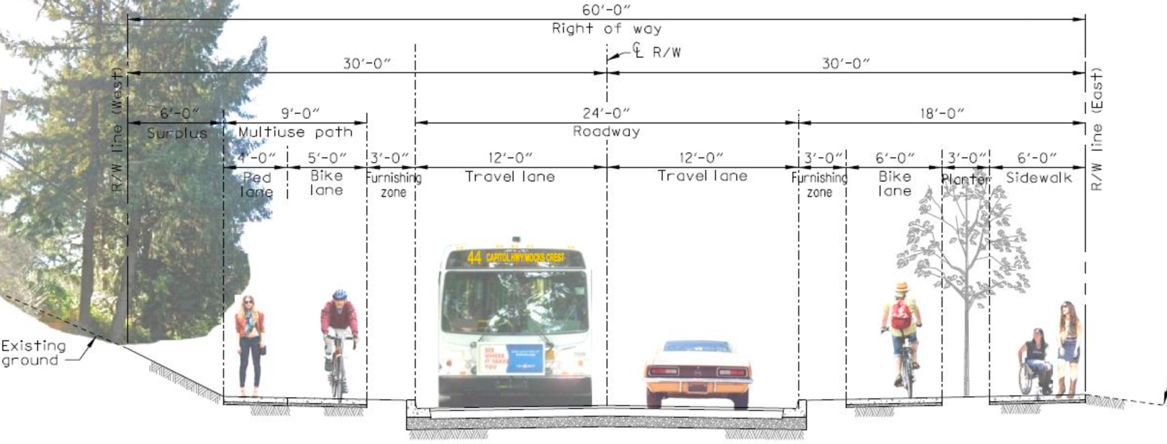
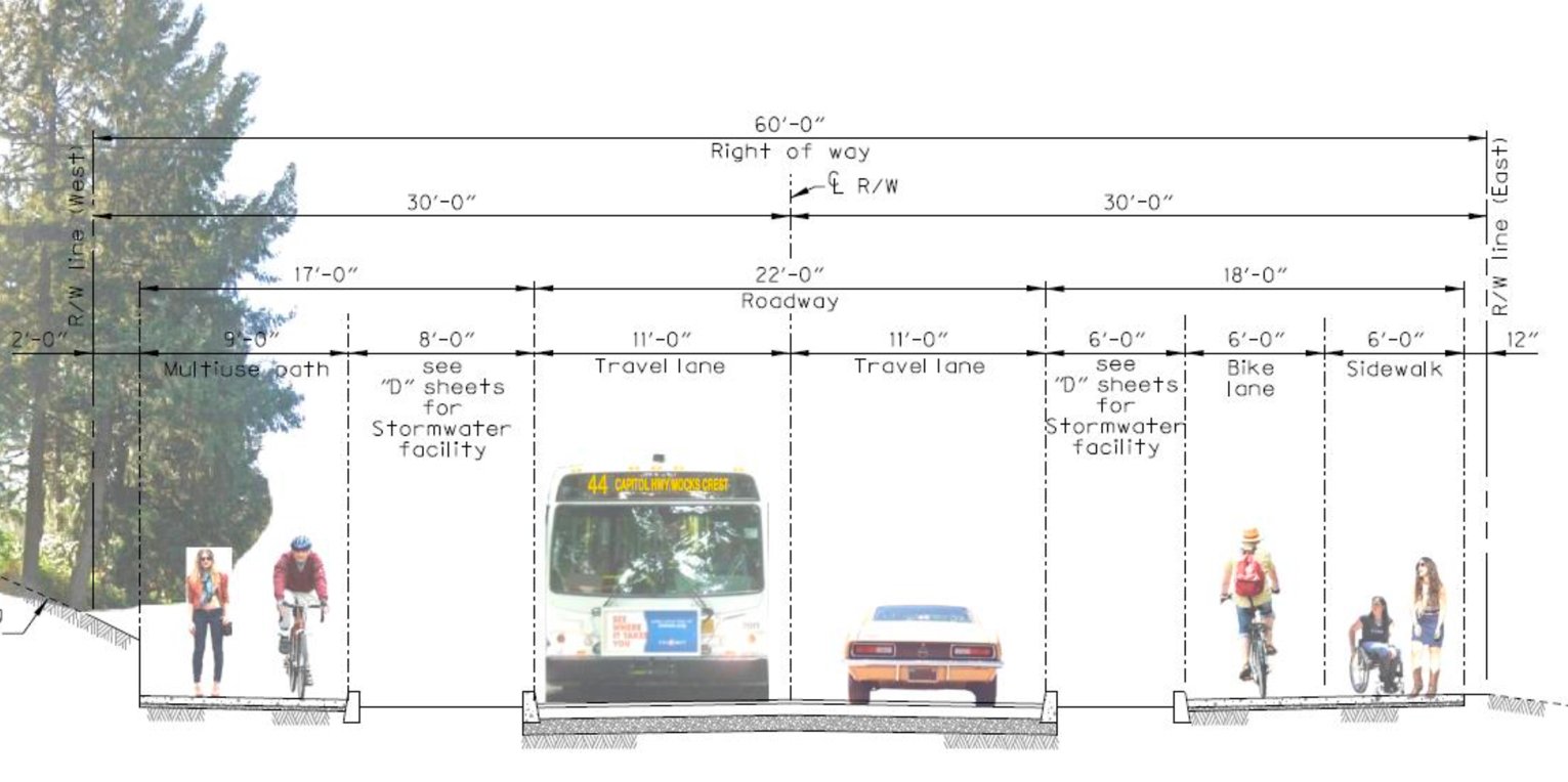
PBOT is showing two different cross-sections that will be used in the 1.1 mile stretch of road. One is above in the lead photo and here’s the other one:
Advertisement
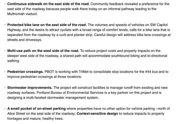
And here are the major project elements (taken from PBOT’s website):
PBOT estimates completion of this project by Fall 2019.
The southern terminus of this project is Taylors Ferry Road, but advocates and planners want it to connect all the way to existing bike lanes on Barbur Blvd. To do this, the project must navigate through a tricky series of large intersections partially controlled by the Oregon Department of Transportation and known as the “Crossroads”. PBOT is using that $2 million in state funding (from House Bill 5006) to separate out the Crossroads portion of the project, “in order to get continuous sidewalks and bike lanes to Barbur Blvd.” Construction of this portion of the project isn’t expected to begin until 2020 “at the earliest” (coordination with the proposed SW Corridor light rail project is likely one culprit for the delay).
Get all the details of tonight’s open house and learn more about the project at PBOT’s website.
— Jonathan Maus: (503) 706-8804, @jonathan_maus on Twitter and jonathan@bikeportland.org
Never miss a story. Sign-up for the daily BP Headlines email.
BikePortland needs your support.

 at Bike Happy Hour: Blanchet House, ped safety, and more")


Thanks for reading.
BikePortland has served this community with independent community journalism since 2005. We rely on subscriptions from readers like you to survive. Your financial support is vital in keeping this valuable resource alive and well.
Please subscribe today to strengthen and expand our work.
I’m a big fan of this. SW Portland has a lot of the same problems that outer SE has in terms of bike/pedestrian infrastructure, IMO. It’s nice to see some improvements (though not on a route I see myself using). And the separated bike lanes are a good indicator that PBT at least has some inkling how to do this stuff right.
That said, it’s ridiculous to me how ODOT and PBT picture Barbur as some sort of major bike thoroughfare. It’s just about the most terrifying road (that has bike lanes) to bike in Portland. Cars/trucks doing 40-50 mph. Lots of businesses and side streets, so potentials for right-hooks are crazy high. The only comparable road I can think of is N/NE Columbia/Lombard, but that has fewer businesses and side streets.
I realize I’m taking a bit of a tangent here about this Barbur thing, but the fact that the Portland Bike map codes/colors Barbur, Terwilliger, and Multnomah Blvds identically is a dangerous farce that clearly gets me worked up.
I second Karsten. Barbur is crazy dangerous.
To me, it only feels safe to ride it downhill.
I think that if “highway” is anywhere in the roads name, it aught to have a protected, separated bike path instead of bike lanes.
All it takes is one idiot drifting into the bike lane and you’re dead. Zero margin for error. But we keep getting unprotected bike lanes on major thuroughfares as solutions!
I don’t mind it downhill from Terwilliger to Hamilton going downhill.
Maybe because you’re a man? A good indicator of the comfort level along a corridor is how close the gender split is to 50/50.
Using bicycle counts is one easy way to tackle low hanging fruit and fix danger spots.
I rode barbur it once after moving here 10 years ago and promised my family I’d never do it again unless it was absolutely necessary. I drive by car into the city this route frequently and that also strongly has solidified my opinion.
You and thousands of others choose to drive on Barbur (and therefore everywhere in SW) mostly out of fear, which is a darn shame for the people who might otherwise ride since it is the straightest and flattest arterial to and from SW Portland. Amongst those forced into cars because of fear around the abysmal road design are business patrons for Multnomah and Hillsdale businesses, users of SW Community Center and anyone associated with the local schools including Wilson HS and all of the schools that feed it.
Yay! Fear wins! Just what the ruling class wants…
I didn’t purchase a home on Alice in 2002 because this project was way past due way back then. Good that it’s finally made it’s way through an obvious “engineering” miasma at last
Great to see the improvements coming, but I sincerely hope the separated bike/walk facilities as pictured above aren’t built like the recent Milwaukie (can’t remember the name now) path that forces people biking to stop at each and every cross street and major driveway, yielding to cross traffic, rather than riding through as car traffic does. It wouldn’t be acceptable to do this on a major thru-fare for drivers (stopping every block). It can’t be considered a transportation corridor if it’s horribly inefficient.
The silliest section of that path had a few stop signs changed to “vehicle crossing ahead” or something like that. It still feels like path users are the ones expected to do all of the yielding but at least I don’t have to worry about a police officer jumping out of the bushes and giving me a ticket for not stopping at a driveway that’s used a couple times a day.
PBOT engineers seem not to have any grasp about the laws of multi-use paths crossing streets. There’s also the question of whether this is maintained (i.e. swept, kept clear of blackberries and other vegetation) by the city or by homeowners and whether electric bikes are allowed. If it’s not a bike lane, mandatory sidepath law does not apply and you can ride in the big lane. Will it take a lawsuit and death to get clarity on this?
Just curious, but how are they handling the drainage issue on this project? From what I remember, the soils along this street are nearly impermeable.
A bridge to nowhere? Taylors Ferry Road is not safe for bicycles, and Barbur is not accesible, so where is bike traffic coming from/going to at the south end of this project?
The bike lanes and sidewalks continue south along SW Capitol Highway (and the SW 49th) all the way up to PCC.
Also, it makes sense to plan for the future. Sidewalks are needed; skipping bike lanes when they have a chance would be crazy.
This project is a game-changer for SW Portland because it will provide an alternate N/S route to Barbur Blvd where none exist today. It will encourage more people to walk and bike in neighborhoods where sidewalks and bike lanes are nearly nonexistent. David, to answer your question about drainage, if you scroll down to the bottom of the website https://www.portlandoregon.gov/Transportation/71661 you will get links to the presentations, including the BES proposal for stormwater. Because there are mostly dirt streets and a lot of infill without infrastructure in this neighborhood, previous designs included huge costs for managing stormwater. BES has already purchased one property for a “regional” stormwater facility and is looking at more, and has incorporated a lot of stormwater pipes into the design to convey the stormwater to nearby creeks. To answer Allan’s question about destinations, this segment is a key connector not only to Multnomah Village and West Portland, but also PCC, Wilson High School, Jackson Middle School, libraries at Capitol Hill and Hillsdale, and other destinations. And I agree that Taylors Ferry should be next!