Thanks in part to the passage of the Fix Our Streets gas tax increase the City of Portland is finally going to build what many consider to be southwest Portland’s highest priority transportation project: A redesign of SW Capitol Highway between Multnomah Village and Taylors Ferry Road.
This one-mile north-south stretch of Capitol Highway has been on the radar of PBOT and neighborhood advocates for over 20 years. It was listed as a priority in the 1996 Capitol Highway Plan and since then has been bounced around many project lists and planning documents. The reason for the delay has been the relatively high cost: Because of its topography and stormwater management issues the project has always been on the expensive side.
Last night at the City’s Bicycle Advisory Committee meeting, PBOT project manager Steven Szigethy said the project is estimated to cost $10-12 million. Funding is now in hand thanks to $3.3 million from the Fix Our Streets fund and another $6-7 million from transportation and stormwater system development charges (fees paid by developers to improve infrastructure).
This key stretch of road currently has little to no shoulder for bicycling or walking or rolling. We experienced it first-hand in 2015 during our Southwest Portland Week when we took an in-depth look at the project with longtime southwest Portland transportation advocate Roger Averbeck.
Averbeck is a member of the Bike Advisory Committee and he saw PBOT’s proposed cross-section for the first time last night. Here’s what PBOT wants to do with the 60-foot right-of-way:
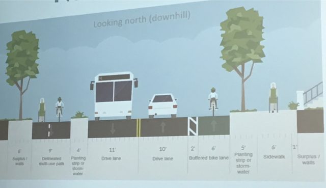
(Graphic: PBOT)
Advertisement
As you can see in the graphic above, the cross-section north of SW Alice Street (which is the majority of the project) will have a nine-foot path for northbound walking and biking traffic separated by a four-foot planting strip. On the west side of the street (southbound) the bikeway would be six-feet wide with a two-foot buffer. Szigethy said PBOT is considering some sort of flex-posts in the buffer to create physical protections.
South of Alice Street as Capitol Highway approached Taylors Ferry and Barbur Blvd., the cross-section would change slightly:
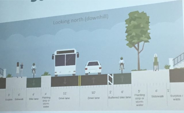
Committee member and southwest Portland resident Keith Liden encouraged PBOT to make sure the new design connects safely to SW Multnomah Blvd and Barbur.
At this point PBOT is still getting feedback on the cross-section design and has several outreach events planned this fall and early next year. Full design will be completed in late 2017 and construction is likely to start in 2019 and end in 2020.
— Jonathan Maus, (503) 706-8804 – jonathan@bikeportland.org
BikePortland is supported by the community (that means you!). Please become a subscriber or make a donation today.



Thanks for reading.
BikePortland has served this community with independent community journalism since 2005. We rely on subscriptions from readers like you to survive. Your financial support is vital in keeping this valuable resource alive and well.
Please subscribe today to strengthen and expand our work.
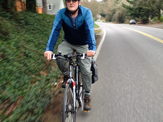
First of all, if people ride like the person in the top photo, they’re making it much more hazardous than need be. Good grief, there’s a reason FRAP has an exception for lanes that are too narrow for safe passing; it’s because gutter hugging on such roads encourages dangerous passing.
Now, on to the proposal. Flex posts in the buffer area are a really, really bad idea. They don’t present any impedance to motor vehicles coming into the bike lane, but they can and do create a hazard for cyclists. They also make it more difficult to pass slower riders and to avoid the inevitable hazardous materials that collect in bike lanes. Some compromises are akin to cutting the child in half.
The six-foot trough in the last drawing had darned well better be designed, built and maintained to drain promptly and completely or we have just another fair-weather build out, which isn’t exactly going to normalize car-free travel. I have to wonder why it’s not elevated above the drainage/planting area.
For something that has been contemplated for two decades, this is a somewhat disappointing first draft. If millions of dollars are going to be spent, at least get the basics done right.
I don’t know man, I don’t have the ovaries to ride in the middle of the lane (on uphills or flats) on a street like this one, especially at rush hour. Ideally, people driving would wait to pass safely when faced with a delay due to someone biking but I have seen so much unsafe behavior by people driving in other contexts that I don’t trust ’em to wait (or to not buzz me out of spite after they DO wait).
The photo at the top is a person riding a bike uphill. This stretch of Capitol climbs over 130 feet.
I dare you to go ride Capitol Hwy during rush hour, uphill, at less than 5mph and “take the lane”. Make sure you take out a life insurance policy first.
Get real.
I did it the other day riding right where the right tires of a car would be, as is my normal practice. The cars lined up behind and passed when they were able. It was a non-issue. Perhaps I hit a lucky day.
“Taking the lane” as many advocate here, is positioning yourself in the middle of the travel lane. I, like you, will commonly ride in the “right tire” position. Riding in the middle makes it more difficult for drivers to pass, and generally makes them much angrier.
Sometimes I’ll assertively ride in the middle or even left track to prevent passing- blind corners, lots of traffic. If I ride the white stripe on a road without a shoulder, sometimes people will blast past at close distance, since there isn’t enough room for a safe pass.
This is mostly in the rural areas (or a greenway, or parts of Cornell where I’m at high speed).
Jonathan,
Any explanation for the different approaches on the northbound versus southbound?
Southbound, going to Barbur, is headed uphill. Many people expressed “concern” about “fast bikes” traveling 30 + mph downhill right by pedestrians. This hill is not much like other hills on SW Capitol Highway or nearby hills.
Yes! My friend and I drove this section out to and back from Alpenrose Dairy, and she casually mentioned it was ger bike commute. I almost threw up I was so scared for her.
Many side streets in that area do have trails but they are more like cyclecross routes.
ALSO HILLS.
Oh nevermind, I thought this was refering to the section that goes from Wilson HS to Barbur Blvd. Is nothing being done about that stretch then?
I want to go in in the middle of the night and stripe my own bikelane eastbound. And dint even get me started on the reason there’s no bikelane on the flyover that crosses Barbur befire joining it. There’s plenty of room.
No. You “just take the lane” at 30mph down that hill. 8-80 and all that yep.
If she is starting at Wilson HS, can’t she just go Vermont > Chestnut > 8th > Terwilliger > Barbur?
Seems like a lot of unnecessary winding around and extra hill climbing assuming the destination is north on Barbur.
Actually it’s pretty short, and it’s all downhill from Wilson to Barbur. But agreed that it would be nice to be able to use Cap Hwy also.
That is why the Red Electric Trail is needed.
Don’t get me started. I always have and always will take the traffic lane from Hillsdale to Barbur on the bike. A bike lane there going downhill is suicide. First time I took the downhill there was in 1953.
Sweet! I’ll tell that to my eight year old daughter! She can just “take the lane” with 50 mph traffic!!
It won’t be going 50 if your daughter takes the lane!
Why don’t you look my daughter in the eye and tell her that. Or should we wait until she’s in a hospital bed first…
Sorry Adam! “I WAS 8” in 1953. :=)
Cross-sections are okay-ish… show me the plan and the treatment at the intersections. What is going to keep auto traffic below 30mph? (A 30mph speed limit sign next to 11ft lanes sure won’t.) For 40mph traffic, we’re supposed to have jersey barriers protecting the bike lane, right?
Also, anything being done between now and 4 years out?
This is definitely not a 2020 design. Shouting “on your left” at puppies is so last decade. How about that bus stopping in the bike lane?
Don’t forget to submit comments on the cross-section through the end of November. Link:
https://www.portlandoregon.gov/transportation/article/591981
This design looks decent. I especially like the use of bioswales as cycleway protection, similar to what was done along Naito near SW Lincoln. Seems odd to have one side protected and the other side buffered though, and it seems like there could be room for an additional bioswale protection on the other side (why is one drive lane 11′; could be 10′. Could also take a foot from the “surplus” area). There may have been more room if this had been designed as a two-way cycleway instead. Or maybe remove one of the tree planting strips and plant trees in the bioswale buffer instead? The one on Naito has this set up and it looks really nice.
I’m guessing you will see a lot of salmoning in the protected lane here. The delineated MUP seems odd, though likely a compromise given the ROW width constraints.
Otherwise, I like that the bike lanes are curb-tight and not door zone lanes. As to the flexible bollards, I say definitely use them; that’s a no brainer.
Also, am I missing something here? this does not look like a 60 foot ROW.
The ROW on Capitol from Barbur to Garden Home Road is very wide. It is generally from one powerline to the powerline on the other side.
I got in contact with the project manager for this and he assured me there was indeed 60′ ROW, even though it does not look like it. Google Street View can be deceiving, it seems.
Many adjacent property owners have encroached on the ROW with various bushes, parking areas, retaining walls, etc. This is very common in SW. When the project goes in, that stuff will all be wiped out, and you can expect to see a few stories in The Oregonian about the city “stealing front yards” from various home owners.
That happened on SW Sunset Blvd several years ago with the controversy.
Right now a lot of people park their cars where the sidewalks will be. What’s PBOT planning to keep the sidewalks clear?
park on the side streets. more people will likely walk and bike with this new design. This neighborhood is crunched between fast highways and roads and muddy trails, but good things have taken place lately. The Walgreen’s by Barbur replace a porn video store.
I don’t live or park my car in the area. It’s not obvious that everyone who lives along the street has enough off street parking once you put in the sidewalks and bike lanes to keep them from parking on the sidewalks. Sending them to side streets sounds nice, but won’t work without enforcement. Which is in short supply in this city. Maybe that’s why there are bike lanes and sidewalks blocked by illegally parked cars all over the city. So what’s PBOT’s plan to keep the million dollar investment in active transportation usable for its intended purpose?
The northbound bus stop will look likely cross the bike lane.
Probably some free parking spots, which will turn some of the bike lanes into door zones of course. Cross sections are optimized for placating advocates.
Much of the expense here is stormwater. I asked about permeable pavement for the bikeway to reduce that cost and was told it would only work if we could keep heavy vehicles off of the bikeway (OK THAT SOUNDS GOOD TO ME.) No can do says Portland Department of Cars.
Ha. Why’d they tell you “No can do” your stormwater-budget-saving measure? Because they didn’t have enough budget for physical barriers (because it’s all being spent on stormwater?) 🙂
That was the case along SW Spring Garden from Taylors Ferry to 19th until sidewalks were put in a few years ago. Parking was a problem for a short time thereafter. It falls onto the abutting property owner to make sure the sidewalk is clear.
I’m pretty sure every single house has a driveway and most have garages. Seems like a non-issue, aside from a few scofflaws who will get parking tickets until they figure it out.
There’s a lot of sidewalk/bike lane parking in Portland. Do you really want to depend on enforcement to keep million dollar investments like this usable for their intended purpose?
What lower speed limit will it have? A lot of Capitol is 20 and 25 mph.
I’ve ridden this downhill a few times. NEVER uphill since I value my life. Overall this design looks like a massive improvement. Only concern is the northbound drive lane is only 10′. I’m thinking the bike-lane buffer paint is going to get worn off real fast.
I am in full support of this project, but ODOT would like everyone to believe you cannot ride a bicycle on Barbur Blvd and would prefer anyone riding to wind around endlessly and go up and down a lot of hills (including Capitol Highway and Terwilliger). Google Maps will tell you accordingly.
Until Barbur Blvd becomes much safer for all modes these other projects will be heavily underutilized and bicycles will continue to be viewed for only sport and recreation amongst the vast majority of SW Portland residents. SW Portland is a fabulous place to commute by bike if you: 1) Ride fast 2) Are strong and confident 3) Have a rearview mirror 4) Are willing to take the lane. This eliminates nearly all of the interested, but concerned. It’s a sad state for 8-80.
Also, this seems like a lot of money and time to spend on one mile of roadway. Foster got less money for twice the distance. I wonder if the fact that 4/5 of our City Council members live in the SW hills had anything to do with this…
And the Foster project ended before the most dangerous, most deplorable section of Foster (east of 205). Wonder how that happened?
Because Foster has bike lanes east of 205 (even though they’re not ideal). The Springwater also goes mostly parallel to Foster past 104th. And Foster becomes less residential east of 205.
It could definitely use sidewalk improvements further out though.
I would love to think that biking has that kind of political pull, but it just ain’t so yet. I think the reason that Foster West of 205 got prioritized has everything to do with the greater political power of largely middle-class residents west of 205 versus largely working-class east of 205, combined with the surfeit of needs east of 205 that makes it hard for East Portlanders to rally around one particular project (there are so many needed!)
The sidewalks (patchiness/narrowness/disrepair/lack) and crossings (lack) are the worst parts about Foster east of 205. The bike lane is not one I would ever ride in, but I do see people riding in it sometimes.
Most likely due to the high amount of crashes and fatalities in the area west of 205. Less peds and people crossing the street further East.
It’s also important to note that the Foster project is also partially in East Portland (82nd to ~88th).
I’m not saying the current Foster project is a bad project (I’m very much looking forward to it!) Just saying that class has a huge impact on politics in this city. I found it easy to not think about that very much when I lived in FoPo; now that I live in Lents, it’s pretty much impossible to ignore that poor people and areas have far less political influence in Portland than others.
I’d like to see your sourcing on the fatalities issue. For 2007-2013, Foster 52nd-88th has three fatalities on this map: https://crashmap.oregonmetro.gov/file/crashes.html
Foster 100th – 150th has the same, three fatalities. (albeit, a slightly longer distance – but not by much, because Foster is more diagonal further west. 2.4 miles vs. 2.1).
I totally agree with you on how classist our city government is. However, The PDC has sunk tons of money into improving the Lents Town Center URA, and many affordable housing projects are on their way. PDC also gave funds to help kickstart local businesses there, with Zoiglhaus being a prime recipient of this funding. PBOT also improved the sidewalks in the area.
So while you are absolutely correct that our city leadership easily discounts low-income neighborhoods, I am not sure you can make this case for Lents specifically.
Lents has been way more effective than most of East Portland at getting the ear of City Hall. Yet, it’s still not immune to the classism. The largest houseless encampment in the city was allowed to exist against city policy on city parkland (the Springwater) in Lents for more than a year without any of the self-organization or controls that e.g. Hazelnut Grove and Right To Dream Too have. We both have strong sympathies with folks experiencing homelessness, but the fact is that most of my neighbors were in uproar, yet nothing was done for months. Do you think the same would have been true for a similar encampment in Eastmoreland or Laurelhurst or Alameda? The answer is no.
When you take a look at the conditions of the infrastructure and the demographics of the population, it’s hard to see how the equitable thing to do is anything other than spending 60+% of the City’s transportation dollars on East Portland. Yet it’s a huge victory just have recently gotten allocations that add up to slightly more than East Portland’s percentage of population. It will take probably five to seven decades at this rate before East Portland has the same level of infrastructure as the inner eastside.
Also – from a practical perspective, affordable housing projects in East Portland don’t exactly help with the concentration of poverty in East Portland. Although it costs more per unit, it makes more sense from an equity perspective – and the perspective of job access for affordable housing residents – to build most of our affordable housing closer in.
Contrast the amount of affordable housing planned for Lents (60+% of units) with the amount built in the South Waterfront, also an URA. I think more than 90% of the units in the South Waterfront are market-rate. I actually don’t think *any* affordable units have been built yet in the South Waterfront but I could be wrong.
http://www.oregonlive.com/portland/index.ssf/2016/08/portland_blows_timeline_to_set.html
All fair points. I do agree we need far more affordable units in town rather than out east. And 60% of roadway funding sounds about right. Just look at the project for 122nd that City Council is so proud of: only getting $2.2M – not nearly enough for what 122nd really needs. Our city leadership loves to use “equity” as reasoning for many things, but when it comes time to actually act on that equity promise, they continually fall short.
Gray’s Landing has 209 units of affordable housing.
Riverplace Parcel 3 (which is about to go in for Design Review) will have a further 209 units of affordable housing.
I was hoping you would chime in with actual numbers, Maccoinnich – thanks! A rough count from here http://www.movingtoportland.net/portland-neighborhoods/close-in-neighborhoods/south-waterfront/ comes up to 2200 housing units total in the SoWa so far. So 209 affordable ones out of that would mean about 90% market rate so far, decreasing to a little more than 80% once the new ones are completed. Still a far cry from the 35% market rate projects that are going up in Lents.
This project connects the largest PCC campus to one of the few walkable, bikeable neighborhoods in SW Portland. SW Patton Road lost their only grocery store earlier this year.
Good point, but they really need to do something about the Barbur/I-5/Capitol Highway intersection; it’s a nightmare.
Yes ! The Barbur transit bridge over I5 doesn’t feel secure with many people walking or biking on it.
I imagine that the cost is being influenced by stormwater management. It is a lot easier to deal with water on a flat stretch like Foster than it is in the SW Hills. As for the politics, this project has been a priority for over two decades. Seems like it is more about getting enough money than it about proximity to Amanda and Steve’s house.
This project has been needed ever since PCC built their campus by SW 49th Ave. This project will connect a grocery-less Multnomah Village to Barbur World Foods, the Barbur Transit Center, and the big Woods Memorial Park.
Is that possibly because protected bikeways and sidewalks and curbs are REALLY expensive to build?
SE Rider! Only politically expensive for the consultants that make the decisions for the city council.
Compare the costs of building a new curb and sidewalk versus re-striping a street. It’s not even close.
I was at the meeting last night, and the project manager said that some retaining walls will need to be built, which is one reason why the project is more expensive than Foster.
Adam H., fierce proponent of protected bike lanes at any cost, is concerned that a protected bikeway costs much more than a bike lane.
That got posted prematurely. Meant to follow up that you should be proud of Portland for spending the money! Clearly it’s an expensive project, but we’re talking a major expansion of the ROW (more accurately: building out the existing ROW), with all the costs that go with it.
No, I’m glad the city is spending the money on protected cycleways. I’m not questioning the costs of them; I know they are more expensive and I know that the stormwater treatment requirements in SW add to the cost. What I am questioning is City Council’s motives in their choices for allocation of funding. Why is one mile of roadway in SW getting more money than Foster and 122nd combined?
Because bus 45 needs it and SW Capitol highway could become a more livable corridor than Barbur. A lot of the soil in SW is clay-like and simple swales often don’t work as well like the other side of the river. Less demand for parking lots and auto repair shops could lead to a grocery / corner store returning to Multnomah Village.
Remember that $1.4B sewer pipe we’re *all* paying for on the water bill? It doesn’t do anything for southwest. Every street project here has to deal with stormwater, which apparently costs more than the paving but isn’t covered by our water bills.
YES! There are next to zero storm drains and curbs for a lot of SW Portland.
Adam – If you look at the Fix Our Streets project list, and the amount of money proportioned to areas around Portland, you’ll see that SW Portland is not getting special treatment by City Council.
The Capitol Hwy project costs more than the Foster project because there is an expensive storm water management aspect to it. It’s not a conspiracy.
I did not read all the comments carefully, but Jonathan’s article needs clarification: “the cross-section north of SW Alice Street (which is the majority of the project) will have a nine-foot path for northbound walking and biking traffic separated by a four-foot planting strip. On the west side of the street (southbound) the bikeway would be six-feet wide with a two-foot buffer.” North of Alice St, the proposed 9 foot MUP is on the westside, uphill, southbound side; and the proposed buffered bike lane is on the eastside, downhill, northbound side.
” . . . will have a nine-foot path for northbound walking and biking traffic separated by a four-foot planting strip. On the west side of the street (southbound) the bikeway would be six-feet wide with a two-foot buffer.”
Is it me, or does this paragraph have the directions backward? In other words, isn’t the protected lane on the west side of the street going uphill (south)?
Trebor,
Jonathan had it backwards, see my post just before yours…
Yes, the paragraph has the directions backwards.
Also, if it was up to me…..skip the bike lane going downhill, as it’s not really needed, although I guess paint is cheap.
The downhill, northbound bike lane isn’t very steep like other busy roads in SW. It won’t be easy to travel 25 mph on a regular bike there.
Ok great some separation. Why not on Foster? Reduce the lanes to 10′ as in this project, and voila separated bike lanes and double the number of people biking. Why the half-assed designs PBOT?
Lack of district-based city council? not sure.
Why all this comparison to Foster, they’re completely different projects with completely different needs and expenses?