

(Image: Knock Software)
One of Portland’s most interesting tech startups is about to move into its next phase: attempting to recruit thousands of local bike users to become rolling bikeway evaluators.
“Look at the pace we could be moving. …They could put this temporary bike lane in and say, ‘Look how much safer people feel overnight.'”
— William Henderson
Knock Software, the company that is simultaneously contracting with the City of Portland on an experimental piece of hardware that aims to radically lower the cost of counting bike traffic, is also setting out to convince 10,000 people to install its mobile app by the end of this summer.
The offer: put the free app on your phone, give each bike trip a quick “thumbs up” or “thumbs down” as you complete it, and the city will be able to parse massive numbers of such trips into data that can rapidly improve Portland’s streets.

of his sensors.
(Photo: M.Andersen/BikePortland)
Knock founder William Henderson said in an interview that the combination of instant real-time bike counts (gathered by Knock’s small, low-cost sensors) and real-time user evaluations (gathered voluntarily from people who install Knock’s upcoming app, which is called Ride) would completely change the city’s ability to prove that its biking improvements are making a difference.
“The city is starting to take this experimental approach to infrastructure,” Henderson said. “Look at the pace we could be moving. … They could put this temporary bike lane in and say, ‘Look how much safer people feel overnight.'”
It’d be a new, lightning-fast way of planning bike infrastructure, he thinks, possible in part because bike infrastructure is so cheap and easily installed, tweaked and reversed.
“They can do manual counts, but there’s no way to effectively say, ‘Look how people feel,'” Henderson said. “You can take a knee-jerk reaction when somebody gets hit or gets killed, but that’s about it.”
A company with a mission to gather data
(Photo: J.Maus/BikePortland)
Henderson, a 2008 Reed College graduate who was previously a top product designer for mobile payments startup Square, is currently funding his company with the cash flow from its first program, a $4 App Store hit that lets people tap their iPhone to log into their Macintosh laptop. In a January interview with BikePortland, Henderson said that success has given his company the luxury to gradually build a company that both makes money and creates social benefits.
His current revenue plan hinges on building tools that will gather data about bicycle use, which can then be sold to cities and states.
He admits his goal of 10,000 mobile app installations in a city that has 19,000 daily bike commuters is audacious.
“We don’t just want to get daily bike commuters, we want to get folks who are biking once a week or twice a week,” Henderson said. “Those trips, from the city’s perspective, might as well not exist.”
Advertisement
But they’re simultaneously the trips that matter most to Portland’s future as a biking city.
“It’s way easier to get someone to use a bike for errands, going to see friends and so on, than it is to turn them into a commuter,” Henderson said.
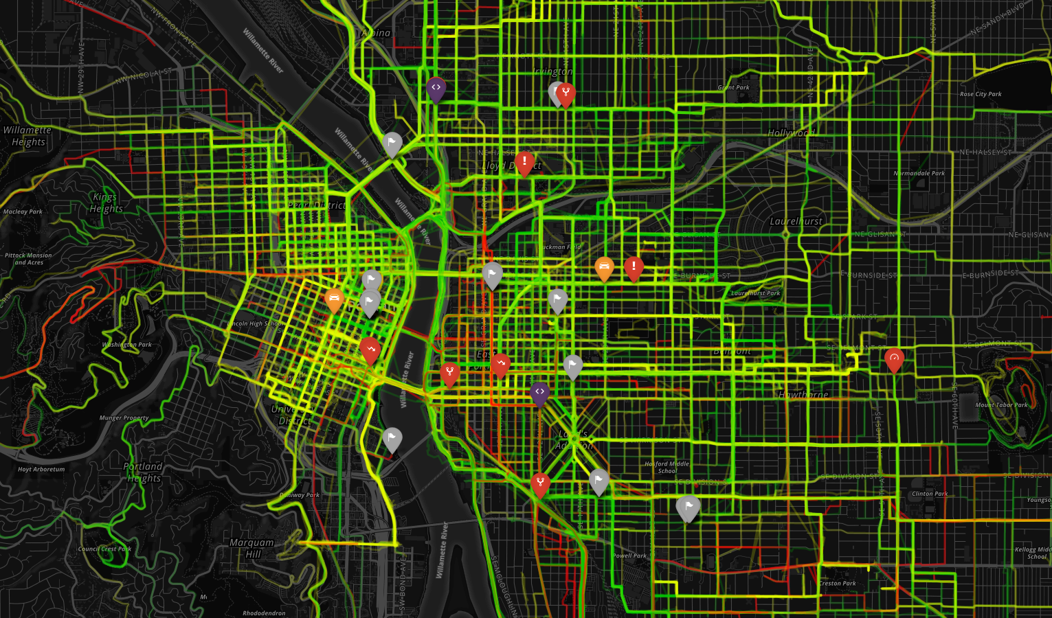
About 100 people are currently using the invitation-only beta version of Ride, Henderson said. They’ve tracked 15,000 rides since April and created the map above.
“The average ride length is 1.2 miles,” he said. “That means that we’re getting errands, we’re getting commutes, we’re getting just short trips that the city wants to get more of.”
Knock’s goal is to eventually be gathering 5,000 to 10,000 good-or-bad ride reports per week.
Opening the doors of advocacy?
Later this year, Henderson hopes to partner with employers who are looking to track and improve their workers’ bike commuting.
“This is a much better way for employees to track their commutes, because they don’t have to do anything,” he said.
The company is also fine-tuning a set of functions that would let people report specific issues with their commutes, to be stored in an open public database, not unlike the city’s existing PDX Reporter app.
Henderson said that as a bike commuter and a Portlander, he sees no shortage of people identifying problems with city streets, from potholes to missing bike lanes.
“When people are talking about issues, it’s frustrating to me that there’s no collection for that,” he said. “It just means that the voices are separate instead of unified. … Right now, there’s nowhere to go with that. you can explode with some road rage every 10 or so incidents. you can gripe about it with your buddies at the bar, but nothing’s going to happen from that.”
A few people, of course, use the traditional method for getting the city to change something: attending a neighborhood or city meeting.
“Only maybe 500 cyclists in the whole city ever do that,” Henderson said. “So if we increase that number to 10,000, that’s huge.”
CORRECTIONS: This story originally stated that the Knock sensor is “matchbox-sized.” The true size of the current counter is closer to a tissue box. Also, we reported that the City of Portland requested issue reporting in the app. That hasn’t happened yet (although Henderson will still maintain a PDX Reporter-like database). And since we first spoke with Henderson, his system has tracked 3,000 more rides — giving him a total of over 15,000 since April. We regret any confusion.


")

Thanks for reading.
BikePortland has served this community with independent community journalism since 2005. We rely on subscriptions from readers like you to survive. Your financial support is vital in keeping this valuable resource alive and well.
Please subscribe today to strengthen and expand our work.
We’ve had a lot of interest in NearlyKilledMe which has a similar purpose – collecting information about near misses people encounter while riding. Between NearlyKilledMe, PDX Reporter, Ride, and OrCycle, there are various different groups trying to achieve something similar through different approaches.
There is definitely some duplication of effort here, although each site/app takes a different approach. I think that’s OK, but I hope that we can work together between these different organizations to have a standardized data format and some central place for all this information to end up. PBOT and ODOT have already expressed interest in using our data.
I appreciate the need to monetize a service somehow if it’s going to be successful long-term, but I’m concerned that making the data from an app like Ride for sale instead of open makes it more difficult for people to use it to make meaningful changes. With open data, anybody can create their own reports and visualizations, possibly identifying trends that somebody else might not have seen. It would be nice if transportation agencies had some kind of grants available for projects like this, to provide funding but allow for the data to be shared openly with anybody who is interested.
Absolutely! We are trying to make this a profitable business so that we can keep working on it and bring it to other cities, but we’re trying to balance that need against the goal of the project, which is to be a service to citizens and planners.
One of the ways we are doing this is by charging money for the tools, *not* the data. The data is open (you can download it right here: http://ride.report/trips/) and anonymous (for privacy reasons we don’t report or share any data that could be used to identify a user). The tools, including the analytics dashboard and the hardware, will be a paid product that we sell to cities and municipalities. We’re hoping that this approach will give us the best of both worlds. We’re also trying to make sure that citizen advocacy groups, non-profits, etc have free or very inexpensive access to the tools.
If you have other ideas about how we can work together, please don’t hesitate to reach out! You can reach me at william at ride dot report.
I’d use the Ride app more if it didn’t use my phone’s GPS all the time, even when the app is not open.
That sounds like a bug =). Could you send us an issue report from the app?
I would if the app didn’t crash when I select the Report Problem menu item.
Never mind, finally got it to send a bug report (I think).
Unfortunately, I would have to mark most of my bike rides with a thumb’s down. On average, at least once per trip, there is something that is incredibly unsafe, whether by design or other road user’s actions.
What might be more useful is something like what is shown on most auto-oriented GPS units: street segments where bikes have to slow down because of congestion from other bikes, too much car traffic, or idiotic maneuvers by any type of user, as well as signals, peds crossing, etc.
Another useful use for this data is to document the routes bikers take to avoid the bad spots (or bad drivers), as well as the frequency, to prioritize future improvements or upgrades. I avoid parts of inner Harrison/Lincoln and Ankeny/Couch/Davis specifically because of the numerous cars using the street, many of which have bike stickers on their bumpers, and a small subset of whom drive at speeds far greater than 20 mph trying to pass other cars (and bikes).
Living here in East Portland near Mall 205, all the routes are terrifying, but some are worse than others, at different times in the day, in different weather and seasons. The idea is to find the least painful ones, then make them less terrifying.
Oh great, another ride-tracking app. Nope. But pull data from the Strava API and I’ll happily use it.
Are you requesting that the app import your Strava data? That’s definitely something we can look into doing…
Yes. I already use Strava for all my commutes. Not so interested in starting up two apps before my commute. I tried to do it once with ORcycle, but couldn’t sustain it.
Totally understand this. We’re trying to make using Ride a no-brainer for folks, which is why it automatically starts and stops your trips. Once you install it you don’t need to do a thing, except (optionally) to tap a button to rate the ride at the end.
Ride user here. Seeing a map being passively filled in with my commuting and errand rides has been fantastic. I’m really excited to see more folks running this.
wouldn’t it be great if bike riders could install small bluetooth device to bike that would automatically get read by readers? it could also help track bike theft. GPS for bikes doesn’t work but installing hundreds of bluetooth readers around town that could track a stolen bike might. Similiar to the “Tile” device https://www.thetileapp.com/
love this project/product. Just giving riders the tools to weigh in on their daily rides and feel like their voice is being heard is a big deal.
SW Jamieson Road and SW 5th Street are not stressful like PBOT’s portion of outer SW Vermont Street. I like the general map, though.
It will be curious to see the difference in reporting for the different ride/rider types. For a daily commute, I know which parts of my ride are uncomfortable, but I take them anyway for lack of better options (no way to get to 181st and Sandy without riding next to 45mph traffic). I’ve since gotten used to the fear, so might thumbs up my ride that has me sharing the road with barreling semis on Marine Drive, but there is no way in hell I would ever recommend a new rider to take the trip, and definitely wouldn’t want it to show green on a map.
Right. A rating is highly personal – it reflects experience level, comfort, etc. The really cool thing is that when you start to get a lot of ratings (think tens or hundreds of thousands), the individual noise starts to disappear. For example, you might have a 10 mile commute with only one bad intersection and thus rate your ride thumbs down. When we look at enough rides, we can see that bad intersection pinpointed. We’ll see it as a red spot, surrounded by a bunch of otherwise green routes.
With enough data, we can look at different rider comfort levels as well. This is a really powerful tool for planners. They could, for example, look at a map that focuses only on riders who tend to be less comfortable biking as compared to the average. I am sure that map would look drastically different than the one we have today.
Ah, that makes sense. Being able to pinpoint to that accuracy will be amazing, and I’m enthusiastic about comfort-level-differentiation as well. I’m a believer in data, so I think this idea’s fabulous. Thanks for clarifying and thanks for your efforts!
I would use it. I don’t really use strava, its more data than I need, but this, if it helped fix trouble spots, I would totally use.
Please sell the city of Toronto on a better app than their official Toronto Cycling app.
Also, please release your app in the Amazon app store or Blackberry World so our blackberry’s can get some love (they can already natively run Android apps)
I’m using Ride, and one thing that isn’t entirely clear from the article is that it is automatic. Unlike Strava, I never have to turn Ride on or off. That’s great.
On the other hand, it counts my trip on the Tram to OHSU each workday as a very steep bicycle ride… :-). It is definitely improving – it used to count taxiing on the runway at PDX as an automobile trip.
I can see that straight horizontal line of the tram. It jumped out at me “where is there a straight street in southwest?!”
Should I report the kia driver’s “nearly right hook” — phone in hand, cheating right with no signal, stopped by my yelling at her drifting toward me and my kid? It wasn’t really a near miss because it happens almost every day and I know what to look for?
What about the cut-me-off driver who didn’t let me in front to go around the utility truck blocking the bike lane (just over the crest of a hill) only to turn right just on the other side of it?
The other 5 conflicts per mile? Maybe if the GPS data could be analyzed in terms of how frequently you have to leave the bike lane?
Also, please report speed. PBOT seems to think that all bikes move at 3-4mph, judging by some of their treatment of visibility and curvature of the bike lanes at corners. (SW Multnomah, Vermont, Capitol & Terwilliger.)
Strava and other data collecting methods are awesome, but the leap between ride data and instant, cheap bike infrastructure is too big.
Dedicated money and a list of projects that we can comment on and contribute to is all we need.