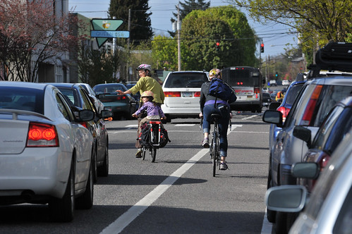
At long last, the Portland Bureau of Transportation is ready to break ground on a re-design of N Williams Avenue. The project began in January 2011 with an eye toward transforming Williams into a street that offered world-class bicycling conditions.
However, as many of you know, just five months into the public process, the project became embroiled in a wide-ranging and often emotional citywide discussion about race and gentrification.
At the end of a 16-month public process, PBOT and the project’s citizen advisory committee finally reached consensus on a suite of changes that will have a dramatic impact on everyone who travels on Williams.
According to PBOT project manager Rich Newlands, the project is slated to begin in the first week of September. The contractor then has three months to complete all the work. That means the new lane configurations and other changes will be fully functional no later than early December.
Here are some highlights of the project (taken directly from PBOT website):
Improved pedestrian crossings:
- 5 crossings will be upgraded with curb extensions and painted crosswalk markings.
- A new traffic signal will be installed at N. Cook Street.
Advertisement
Traffic calming:
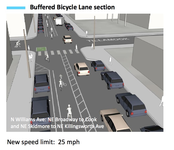
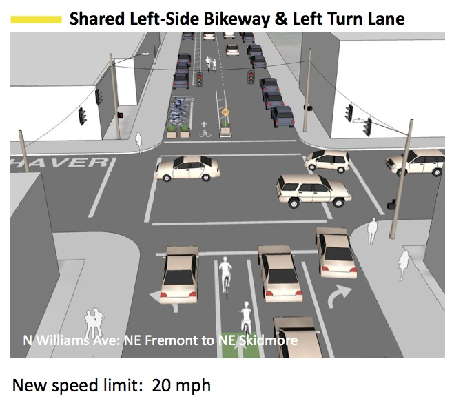
- Speeds are being reduced from 30 to 25 mph and 20 mph in the main commercial section between Fremont and Skidmore.
- Two lanes of motor vehicle travel will be changed into one lane of motor vehicle travel and one left-side bicycle lane on most of the corridor, with the exception of the section between Fremont and Skidmore where travelers will share the road. This change will accommodate growing bicycle travel, eliminate conflicts with transit, and improve safety for pedestrians, who no longer will be faced with the “double threat” of crossing two lanes of traffic.
Enhanced transit and bike travel:
- Transit and bicycle traffic will both flow more smoothly as the bicycle lane moves from the right side of the street to the left, eliminating conflict with buses which make frequent right-side stops
- The bicycle lane also will be widened from five feet to 12 feet to accommodate the only roadway in Portland that has reached capacity for bicycle users. N Williams is Portland’s busiest bicycle corridor with 4,000 cyclists at peak hour
Driving – what’s new, what remains the same:
Improving the environment for transit, biking and walking gives people choices and increases the capacity of the street to handle more travelers in this rapidly developing urban neighborhood.
- Turn lanes will be maintained for drivers, to miniimize congestion from turning vehicles. Drivers will need to look out for bicycles on the left as they turn.
- The new traffic signal at N. Cook will make that crossing safer and more predictable for drivers and all travelers.
Public Art:
- Public art will be installed to honor the rich history of the neighborhood as a center for Portland’s African-American community
The new design will consist of two basic configurations. Most of the project (which stretches from Broadway to Killingsworth) will feature four lanes: a left-side buffered bicycle travel lane, two parking lanes, and a standard travel lane:
And in the busiest section of Williams — from Fremont to Skidmore — the configuration will be what PBOT refers to as, “Shared Left-Side Bikeway & Left Turn Lane”:
One unexpected thing that emerged from the Williams project public process was a desire by many people to make NE Rodney into a neighborhood greenway. Rodney is used as an alternate for people who don’t like the hustle-and-bustle of Williams. Newlands said PBOT plans to finish all the work on Williams before turning any attention to Rodney. There’s a bit of design and public process work that remains for Rodney and PBOT says that phase of the project will be put out for bid in spring 2015.
Learn more the North Williams Safety Project on PBOT’s website and browse our archives for past coverage.


Thanks for reading.
BikePortland has served this community with independent community journalism since 2005. We rely on subscriptions from readers like you to survive. Your financial support is vital in keeping this valuable resource alive and well.
Please subscribe today to strengthen and expand our work.
Does anyone know how and where the bike lane will transition from the right side bike lane South of this area to the new left side bike lane, and then back to the right again on the North end? Seems like a challenging problem and I’ve not seen anything in the various design graphics that have been presented here or at the events held by PBOT.
Jack, the transition will start in the middle of the block between N Weidler and N Broadway.
You can see it on page 14 of the report: https://www.portlandoregon.gov/transportation/article/417219
At the north end, Killingsworth, the bike lane is (now) in the middle, between the left only and right only auto lanes, as bikes can continue northbound north of Killingsworth.
It will be interesting to see how these improvements will handle the 5:30 rush hour traffic. It could be crazy! I am certainly looking forward to the changes though.
except in the box at Fremont/Cook, it should be similar to southbound Vancovuer during the AM peak – a road that is already mostly one lane.
That’s an interesting question. Some (most?) of the rush hour traffic is people using Williams as a bypass for I-5, and if they find it’s no picnic, they may just stay on I-5.
Exactly. We need to make it as difficult as possible to use this as a bypass for I-5. Frankly, I think we need a city strategy that makes it more difficult for Vancouver drivers to get in to the city, and much easier for them to get out. If you have a 5 lane bridge, make 2 inbound lanes, and 3 outbound. The backups should snake into the suburbs in the morning. That will help eliminate backups in the afternoon that clog up the city.
Right. — and that’s perfect reason — particularly in this case — to install concrete diverters at several points along the Rodney Ave. bikeway which is being developed as an ancillary feature of this project.
The rush hour traffic will find other roads to drive on making them more congested. Mississippi, Interstate, MLK will ave to handle more rush hour traffic. I-5 is too slow already for people to go back onto it. It is unfair for all of those corridors as none of that traffic is the local residents. It has been unfair for Williams for too long already. In the middle of the day, Williams is just fine. I-5 is the one that needs to be fixed somehow??
A few thoughts:
1) On the busiest bike route in the more bike-friendly big city in the US, it still boggles my mind that the improvement will not include a protected bike lane, and that some stretches will still be reduced to sharrows.
2) “Shared Left-Side Bikeway & Left Turn Lane” = is just another way to say sharrows or maybe mixing zone. Best practice, though, holds that to make biking to both feel safe and be safe you separate bikes from cars in space and time.
3) I’d be willing to bet that within a year, the car volumes on the stretch between Fremont and Skidmore will be low enough to easily take it down to one car lane.
Why oh why are they planning on putting parking on the other side of the bike lane?
Exactly. Why in the hell are there so many different bikeway configurations? Standardize this stuff already. I know, variables…blah blah. Lots of half-baked designs in this city.
math, blah, blah.
Even on blocks where there are no buildings, no curb cuts, no reason for autoparking to *need* to be next to the curb. It’s just unnecessarily adding conflict points.
I wish for the streets that “must have” on street parking that they were all to the left of the bike lane. For single occupant motor vehicles parked on the left of bike lanes, this would seem to reduce the possibility of a dooring. Having vehicles parked on the right of bike lanes on one-way streets is ridiculous from a safety perspective. IMHO
using cars to *protect* bike lanes is considered a dangerous and obsolete form of infrastructure in europe due to low visibility and increased conflict at intersections. the generic approach in europe is to remove on street parking when installing a bike facility. unfortunately many of those who advocate for “cycle tracks” in north america are so car-centric that they accept the “need” to maintain or increase free cage storage space as a given.
Excellent points.
I was re-reading my post and realized it starts off slightly vague. What I intended to say was that one one-way streets which require on-street-parking I feel it is safer to have the bike lanes on the left side of the one-way in lieu of protected bike lanes. In such an arrangement, on street car parking is maintained yet it decreases the chance of driver-side doorings. Ideally there wouldn’t be parking on the right side of one-ways and people could more safely bike on the left (with optional car parking along the curb) or on the right (without car parking ever) of one-ways.
Just in time for the bike commuter challenge… could get messy!
There are quite of few of us who both ride and drive this corridor (I exit the freeway here when driving). As a driver, I’m quite bummed that there doesn’t appear to be any solution to the hwy exit/on ramp issue at the New Seasons. Restricting the auto traffic without solutions elsewhere is frustrating. If you’ve ever tried to exit the freeway at Emanuel at rush hour you know what I’m talking about.
The City and ODOT agreed a while back that storing excess demand on the freeway off-ramp, and letting it slowly meter into the local neighborhood, is much better than a signal fueled flush of cars.
if it’s frustrating then don’t drive…
This design, while an improvement, is not ideal. It follows no existing standard and really does not improve safety at all. From the diagrams, it seems that there is plenty of room to swap the bike lane and parking lane, creating a protected bike lane. Instead we will have people driving in the bike lane and using it as a staging area before parking.
Designs like these are dangerous because they create the illusion of safety while providing no exta benefits. This is not a world-class bikeway. Another example of PBOT trying to appease everyone to the detriment of safety for all.
I agree. It seems like this is trying to achieve something without taking the hard steps to move past old design. Conflict is baked in from the very start.
I for one would love to see/hear the “powers that be” stand up for parking removal in situations like this.
A left side protected bike lane is likely to have repeated door openings toward that bike lane. A right side protected bike lane could have worked better if the bus didn’t pull out and there was a parking lane island like they do in Vancouver, BC.
From the first illustration in the post, it does seem like there could be a 4 foot wide buffer between a bike lane next to the left-side curb and auto parking to the right of that bike lane. Because there is no need of a buffer between parking and traffic lane, the two buffers shown in the existing plan could be combined and placed between bike and parking.
“while providing no exta benefits”
an absolutist statement without an argument or a citation. while i am not a fan of mixing zones or left-side bike lanes, there is about as much “evidence” that buffered bike lanes increase quote unquote safety as danish cycle tracks. and the current design of williams has long stretches of buffered bike lanes.
“4,000 cyclists at peak hour”
Whoa, is that right? Perhaps it is at “peak hours?” (more than one)?
A standard-size lane normally has capacity for 2000 cars per hour if it has no intersections (eg freeway or rural highway), and at that volume it will be slow-and-go. 4000 bikes in 1 hour is equal to the capacity of northbound I-5 south of the Rose Quarter! The 2 existing lanes for cars on Williams probably have a capacity for less than 3000 cars per hours.
Perhaps it is 4000 cyclists during the evening rush-hour, spread over 3 or 4 hours?
maybe 4,000 per day? or 400 at the pm peak. Ankeny gets 200+ during the PM peak at 20th and 28th.
Looks like it’s a mistake. There’s an article here https://www.portlandoregon.gov/transportation/article/398932
which says
“More than 4,000 people bike up North Williams Avenue each day in the warm months. In the evening, the street moves about 400 bikes and 800 motor vehicles per hour in the section south of Russell Street. ”
My guess is they are using the same statistics, but the 4000 per day is the right one.
From the picture of Amsterdam on page 6: “A channelized cycle track in Amsterdam is the height of user separation. The recommended concept for North Williams seeks to improve user comfort without using as high a level of physical separation.” It looks like it will be an improvement, but it will be far from as comfortable feeling as that channelized bike lane, and that is why Portland will struggle to get bike modal share up above 10%, not to mention to Netherlands’ range. I always struggle with the question “should bike advocates accept infrastructure “improvements” that are less than the standard set by the Netherlands?” I guess we have to?
https://www.portlandoregon.gov/transportation/article/417219
replacing a sub-par facility (door zone bike lane) with another sub-par facility (the unsignaled north american bike sidewalk) is not progress. if we are going to build cycletracks then we need to effing do it right:
remove free vehicle storage space and either raise the bikeway bed a little (the preferred danish approach) or install a low curb/barrier that does not impair site lines at intersections.
gah: sight lines
“I always struggle with the question “should bike advocates accept infrastructure “improvements” that are less than the standard set by the Netherlands?” I guess we have to?”
You are correct, we have to. There just isn’t the funding to do Netherlands/Denmark-level infrastructure, and it’s doubtful there ever will be. Everyone wants more bike infrastructure, but they get stingy when it comes to paying for it. People went apoplectic about the street fee, and will react the same about a local income/sales tax too. The only popular option (which was demonstrated here) about funding is “tax someone else but not me”.
Man, if only the Foster Road streetscape project could have come to fruition in this amount of time. It’s over a decade in the making and we are still years away from the vague timeline that keeps traveling into the future.
Regardless, cheers for Williams Ave, can’t wait to check it out.
My wife’s shop is in the William’s commercial core between Fremont and Skidmore. I am really excited to see how these changes might positively affect her business. I am hoping that by making Williams less attractive to pass through drivers looking to avoid I-5, it will make the street more attractive to folks who might want to spend some time, and money :), in the neighborhood.
Is that 4,000 cyclists total during the peak use, or 4,000 cyclists *per hour* during peak use? Either way, that makes Williams one of Portland’s biggest transportation corridors, regardless of mode.
“Under normal conditions, the maximum practical working capacities (totals in both directions) are 800 vehicles per hour for two-lane highways; 1, 400 vehicles per hour for three-lane highways; and 2,800 vehicles per hour for four-lane highways.” (From From http://www.clrp.cornell.edu/tip_sheets/pdf/history/4-capacity.pdf)
If we’ve learned anything from the Division / Clinton debacle, they should do the Greenway treatment (including diversion) on Rodney ASAP. There’s plenty of time to drop some of these in there before September: http://goo.gl/x6XPid
Really, really disappointed that the Rodney greenway has to wait… for no good reason, as far as I can tell.
I’m a bit worried about that N Williams and N Cook intersection too – particularly in the winter months when it will be dark on the commute home.
It needs streetcars.
I did the count on N Williams and Russell last year. As I recall, it was about 750 bikes per hour in the 5pm – 6pm window.
PBOT multiplies this by 5 to get the daily count. Which comes out to be 4000 on N Williams.
Ted Buehler
A couple improvements have come in in the last couple months.
– lowered speed limits — especially the 20 mph through the emerging business district — are a big improvement.
– dedicated through lane for bikes on Williams at Skidmore, bikes won’d get stuck behind left-turning cars that are waiting for pedestrians.
Thanks PBOT!
Ted Buehler
In my daily ride up Williams, the worst section is the “Copenhagen” style turn from Weidler to go left onto Williams. With the intersection of bikes, buses and cars coming up from the Rose Quarter and bikes trying to merge from Weidler it can be very messy. There is not enough room for all the bikes on a busy summer afternoon. It doesn’t appear that the problem will be fixed.
Fwiw, I gave up on Williams last year.
Between a series of ever-more screwy plans- none of which seemed to deal with the increase in traffic from the new condo complexes- or the congestion caused by their lack of parking facilities- I decided that the whole situation was FUBAR and took to using Rodney: no buses; no pedestrians; almost no traffic; no problem.
Sure, it’s so chock-full of chuck holes that riding it might be good training for the Paris-Roubaix, but at this point I feel it’s less of a hazard than Williams is or will become.
It is hard to believe the amount of change on Williams in the last few years. 10 years ago crime was rampant there. 2 years ago there were a lot of car windows being smashed daily/ nightly. Higher property values mean less rentals, so that element is moving to another part of town.
The Interstate corridor has improved in the last year also with the new buildings starting to open and new businesses opening up. It also is becoming a nice walkable neighborhood. Perhaps there will be biking improvements on Interstate someday also. It is hard to believe how those bike lanes suddenly just stop and start. Then again, there was less public input for Interstate project.