(Photos by J. Maus/BikePortland)
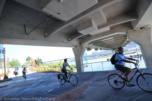
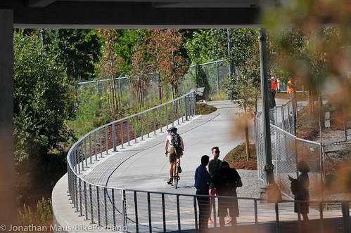
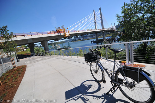
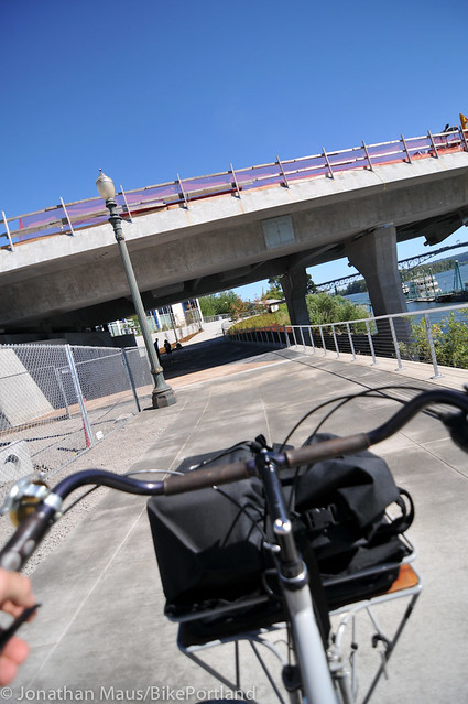
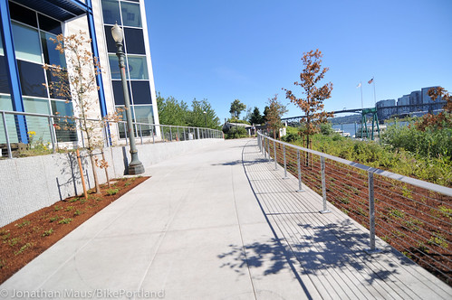
After a 14-month closure, TriMet re-opened the Eastbank Esplanade path (which some are calling the Eastside Greenway Trail) between OMSI and SE Caruthers Street this afternoon. The new, 14-foot wide path begins just south of OMSI, goes under the Tilikum Crossing Bridge and then back up to Caruthers just south of the Portland Opera headquarters.
I rolled over today for a closer look.
Advertisement
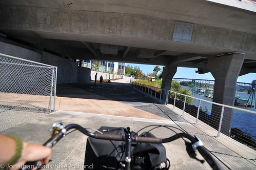
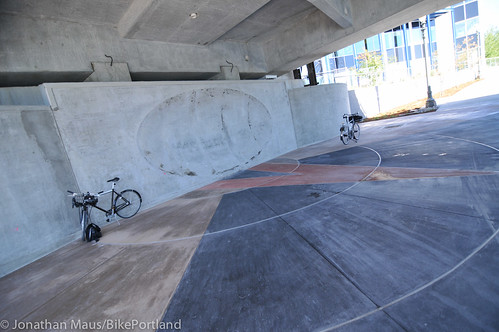
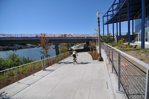
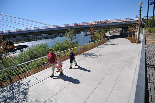
The new section of path is quite nice. The area under the bridge reminds me of being under the Morrison Bridge; but without all the freeway noise and without any structures constraining the path. The wide plaza area under the bridge features a decorative design in the pavement and the wall will eventually include a tiled, public art featured called the “sonic dish.”
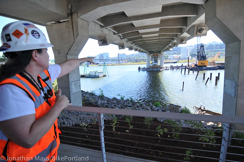
PBOT’s Theresa Boyle said during a tour of the site today that the dish is meant to “enliven the spaces under the bridge” by reflecting the sounds of the Willamette River and maintain the artistic concept that the bridge itself is a living, breathing thing. Boyle said the art will be completed by August.
For those traveling north-south in this area, the new bike lanes and other bike access changes made to Water Avenue last year as part of the detour plans will remain in place. That means you’ll have two options. Faster riders might prefer the on-street bike lanes of Water Ave. while others might prefer that multi-use path environment closer to the river.
Eventually, we’ll be able to connect from this new path up to the bikeways on the Tilikum Bridge, but it’s not slated to open until September of 2015.
— Learn more at via TriMet’s official announcement.


Thanks for reading.
BikePortland has served this community with independent community journalism since 2005. We rely on subscriptions from readers like you to survive. Your financial support is vital in keeping this valuable resource alive and well.
Please subscribe today to strengthen and expand our work.
Sweet!
Is the bike access to the bridge deck supposed to happen at the same time as the transit? I noticed on their timeline they have a months scheduled in for training, which presumably people walking and riding won’t need….
A little birdie told me that they wanted to open it for every mode at once so that people don’t get used to walking or riding it without trains present. The birdie also said they are ahead of schedule and under budget and are trying to add some features that were previously cut for time/budget.
We should all have such informed birdies!
The replacement Gideon Street ped bridge is back?!
Funny, when the pavement was done for the Bethany widening they opened all lanes for cars before it had been striped for bike lanes. No concern there about cars getting used to the road for a couple of months without bikes present. The minimal-size bike lanes were only added at the very end.
same ‘they’ or different ‘they’?
The royal they.
Dave, is there any chance they could open for peds/bikes at the same time they start non-revenue service? I know that rail lines usually have 1 to 4 weeks of full-time operations, without passengers, before opening for people to ride. The trains would be operating on a normal schedule during that time, so it would make sense to have bikes and pedestrians using the bridge.
In fact, the Trimet train operators should not “get used to it” without walkers and cyclists present!
That’s a nice thought, but not practical, or desirable, from TriMet’s point of view, I suspect. Putting untrained MAX, bus, and streetcar operators on a new part of the system with the public seems like a disaster waiting to happen. This isn’t like a new roadway opening. There’s many conflicting movements and operating procedures that probably need to be worked out. As much as I’d like to start using it today, I’ll gladly wait til it’s safe and sound. Perhaps we should hope the training is completed early rather than trying to insert ourselves into the mix.
How many conflicts do they have planned? I can’t find anything about the connections on each side.
I mean the Hawthorne Bridge, you never cross the path of any cars.
Not sure if this was in sarcasm, but westbound bikes and peds cross the ramp from Naito Parkway southbound and the ramp to OR 99E southbound along the viaduct.
Eastbound, you can exit to the Springwater without crossing traffic. Same with the Waterfront Park path.
Yes, there are some crossings if you continue either east or west.
Sorry, I meant eastbound but you’re right. If you’re sticking to the MUPs you don’t have to cross traffic there.
Joseph, I have no idea but if the birdie alights on my shoulder again, I’ll ask.
Was the “textured” bike lane entirely nixed?
It would be just the sort of “popular” amenity to return unannounced.
Referring to the “singing bridge” feature? Enquiring minds would like to know!
This confirms my commute route tomorrow morning. Cool news.
Me too. Would have ridden it home if I’d known. Nice to finally have the mandatory detour over with.
Psyfalcon, everything I’ve heard is that the bridge will open to all modes at the same time. Unfortunately.
Good to see this path reopened. I don’t mind riding on Water Ave., but I prefer the scenic route. I just found out about this today riding back home and stopped to take a photo or two of the bridge.
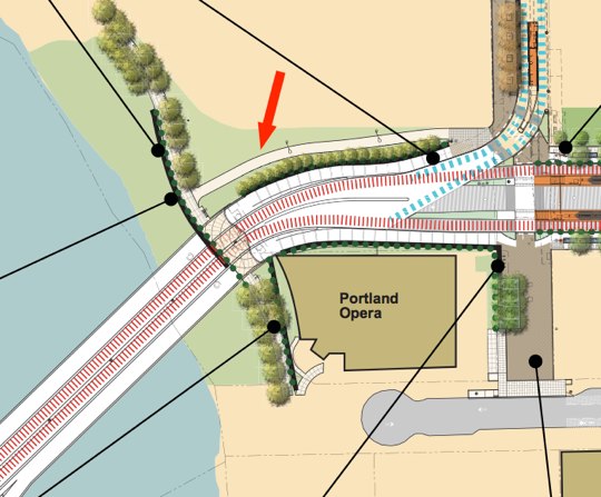
that rendering is really hard to understand, will you be able to exit from the south side onto the springwater trail?
It looks like you can either cross the tracks to the path at the north side, or use SE Old Water Avenue and SE Carruthers place to loop around the Portland Opera. It seems like there wasn’t room for a path in between the bridge and the Opera building.
The bridge is open now, if you go when the workers aren’t there. Just sayin’….
Wow!! The Critical Mass ride really worked.
It would be really nice if they could open this to bikes/peds next spring. It’s painful to ride north past that beautiful bridge when I am riding from South Waterfront to Ladd’s.
awesome can’t wait to ride it along with crossing bridge by bike. 🙂
The new section of the path looks great. And I love that new bridge, I look at it very longingly whenever I’m stuck in traffic on the Marquam.
Enjoy it! We are all paying dearly for it.
Should last a really long time, without cars wearing it down.
Your definition of “paying dearly” is laughable. The design/build for this bridge came at $135 million, which is less than half of the cost of the new Sellwood Bridge, and less than ODOT and WSDOT spent on PLANNING for the failed CRC.
Don’t mind MP; he thinks any project west of I-205 is a waste of money.
Well, he’s in luck, then. ODOT just spent $93 million to build two new bridges in Troutdale.
yup this is a green bridge….. yay! pay dearly with cars on it.. 😉
$135M for such a spectacular AND useful bridge seems pretty good, compared to what a lot of stuff costs these days.
Yea!!!! I will ride it tonight. I always dread having to go through the Water Ave. asphalt jungle. The road heat and various petroleum fumes through there are sickening. No more! Yea!!!!!!
It was really cool getting what was by far the closest look I’ve yet had of this bridge.
But why was the gate at the north end of the OMSI property nearly closed and blocking the path tonight? It was wide open through the entire closure.
That’s what I want to know, too! In my 6 years of living in Portland and commuting past OMSI most of that time, I’ve never seen that gate like that before. One can still pass through, but you need to practically stop your bike to maneuver through. Perhaps this is a speed control during OMSI’s summer classes?
Sonic dish? Buskers! Jugglers! Concerts!!
The nearly closed gates across the path just south of the Hawthorne bridge appear to be set that way semi-permanently. Anyone know why this was done? Sure seems a long way from MUTCD compliance.
The nearly closed gates across the path just south of the Hawthorne bridge appear to be set that way semi-permanently. Anyone know why this was done? Sure seems a long way from MUTCD compliance.