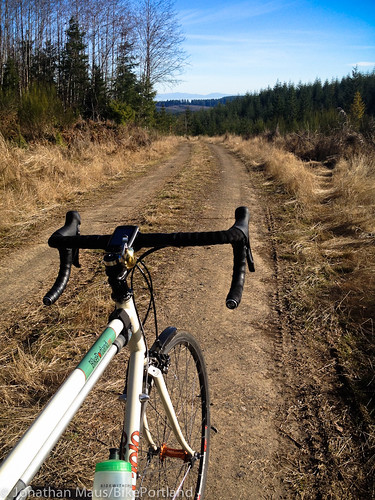
to be ridden just north of the Scappoose-Vernonia Hwy.
(Photos by J. Maus/BikePortland)
When the sun comes out around here in January, folks that enjoy bicycling take full advantage. This past weekend was a real gem weather-wise, and I’m sure I wasn’t the only one who grabbed the opportunity for some two-wheeled adventure. What I found were some off-the-beaten-path backroads that I enjoyed so much I’ve decided to share them here on the Front Page.
—
Wanting to do my first century of 2014, I ventured over to RidewithGPS.com (a site — based right here in Portland! — that I could not live without these days) to map out one of my oldies but goodies — the Portland-Vernonia-Scappoose loop. This is a fantastic loop that I highly recommend.
About 60 miles in, just a few miles north of Vernonia Lake on Nehalem Highway, the route begins heading back to Portland. It’s at the junction of the Nehalem and Scappoose-Vernonia highways that I decided to try something new.
After riding quiet Washington County farm roads and the carfree Banks-Vernonia Trail for several hours, the thought of riding 20 miles on the Scappoose-Vernonia Highway didn’t appeal to me. It’s not a terrible place to ride, but there isn’t much shoulder and knowing that the area is full of great backroads makes staying on the pavement seem rather boring by comparison. Some of you might have ridden (or heard of) the Crown-Zellerbach Trail that runs alongside the highway (we wrote about it back in May). That’s a nice ride, but I wanted to find something new. The sun was shining, I had confidence in my bike, my GPS device, and my legs, so I figured I’d leave my pre-determined route and do some exploring.
The best part of my day started after my GPS device beeped: “Off-course”.
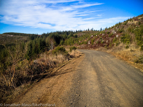
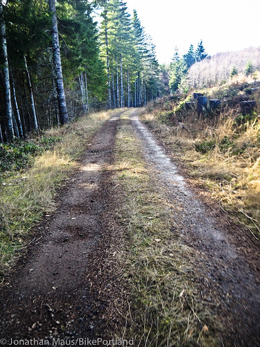
Just a half-mile or so on the Scappoose-Vernonia Hwy (east of the Nehalem Hwy junction), I turned north onto Pittsburg Road. The name comes from a nearby, unincorporated town that was named after Pittsburgh, Pennsylvania by a settler named Peter Brous in 1879. The road itself is a mix of hard-packed dirt and some gravel that climbs about 1,100 feet in just over six miles.
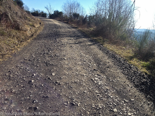
Off the highway, I rode in peace, without constantly glancing over my shoulder. Backroads are my favorite roads. I love the solitude and the added challenge of riding my “road” bike (a Cielo Sportif Classic with 28 mm tires) through the varying types of dirt (hard-pack, loose, dry wet, flat, off-camber) and rocks (small loose gravel to the embedded rocks as seen in the photo below).
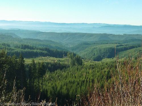
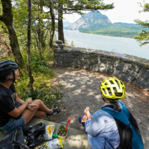
Near the summit, Pittsburg Road took me right to the southern tip of the Forest Grove District State Forest and Baker Point (an old fire lookout) at an elevation of about 1,800 feet. From there, the views toward the south were fantastic. I continued east along the ridge for a few more miles. Then, just before dropping into a valley that would loop me back (south) to Scappoose, I was rewarded with grand views of Mt. St. Helens and Mt. Adams.
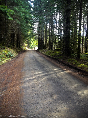
As I headed south I left Pittsburg Road and found my way into a valley and onto Wilark Road. Suddenly the Clatskanie River tumbled nearby and I wound my way between clear-cuts, creeks, ponds, and forested groves. Wilark eventually turns into Alder Creek Road, which I then followed a few more miles south. It was at about mile 74 that the road became paved, right at the small rural community of Spitzenberg.
At this point — with about 14 miles of dirt/gravel backroads behind me — I could choose whether to take the highway or the Crown Zellerbach Trail back to Scappoose. Getting short on time, I opted for the highway. It was only six miles to Scappoose and it’s all downhill, so sharing the road wasn’t too bad.
It wasn’t until I met back up with the C-Z Trail that it dawned on me what a nice loop this would make. Combine this Pittsburg-Wilark-Alder Creek logging road route with the C-Z Trail and you’ve got a fun adventure that is nearly 100% off the highway. RidewithGPS.com says the loop would be 43 miles with about 4,300 feet of climbing. There are plenty of places to park in Scappoose near the start of the C-Z Trail, or for those of you who are up for it, it’s about 25 miles on Highway 30 from Portland. Here’s the loop in map form:
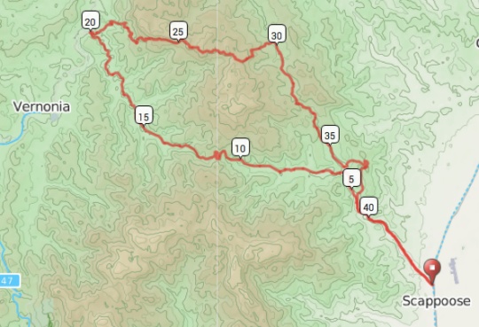
This whole area, on both sides of Scappoose-Vernonia Hwy, is full of great dirt roads that are perfect for cycling on. I can’t wait for the longer and warmer days of summer to really get to know them better.
Note: The logging roads in this area are open to public recreational use under the management and ownership of private timber companies. Follow the rules posted on signs along the way. I would also recommend riding this on weekends when there aren’t active logging operations.
For more info, check out these routes on RidewithGPS
– Vernonia-Scappoose Century
– Crown Zellerbach Trail-Baker Point Loop


Thanks for reading.
BikePortland has served this community with independent community journalism since 2005. We rely on subscriptions from readers like you to survive. Your financial support is vital in keeping this valuable resource alive and well.
Please subscribe today to strengthen and expand our work.
Nice write-up, Jonathan. The photos are particularly helpful in getting an idea about what you’d need to be ready for, surface-wise. To a cyclist here’s a thousand gradations of unpaved…
Any guess on how difficult/easy this route would be to follow without GPS? – maybe just a USGS map (or other better map…?). Any road signing up there?
There’s some great quiet paved roads up this way, too – the ride from Mist to Clatskanie, Apiary Rd., Meissner, and more – these maps show mostly paved roads:
http://www.portlandoregon.gov/transportation/index.cfm?c=36638&a=316792
Hi Jeff,
That’s a good question about whether or not you could find your way without a GPS. I don’t recall any road signs at all once I left the highway so it might be tough unless you have good orienteering skills and a good map. There are quite a few roads and several intersections that could get you lost I suppose.
As a general rule, traveling by any means in Forest Service territory and in the mountains, be prepared, have maps, and etc. I’ve spent a lot of time on mountain roads and just about everywhere it is easy to get lost. Traveling by bicycle it is more important than with driving or even walking to be able to keep track of where you are and be prepared. A bicycle gives me the opportunity to travel far faster into remote territory than I can by foot, but leaves me more vulnerable than I would be in a car.
Oh Jonathan, what gadget were you using? Long story short, would a GPS/Android equipped cellphone with a full battery charge do the trick?
I’m using a Garmin 800 (supplied by Portland Bicycle Studio). And yes, I’m sure a phone GPS system would work just fine too. I just don’t trust phone batteries and I like to keep my phone charged for photos and emergencies.
Tip for everyone: when traveling outside normal cell phone range like in the forest or out in remote areas, put your phone on airplane mode when you don’t need to communicate (which will be most of the time). The battery will last way longer.
Um, even though it really shouldn’t (GPS is receive only), the iPhone disables the GPS Radio while in Airplane Mode. Makes it kinda useless out in the woods for finding your way out. Best option is to find a map app that let’s you pre-cache map data, then just turn off Cellular data and Bluetooth (unless needed by bike computer) to preserve battery. That way GPS will still show your location on your cached maps and you will have cellular voice turned on if there is an emergency on the ride (or at home) and you happen to have signal. Or just buy a Morphie Juice Pack or other extra battery power phone case, it will last all epic ride.
True… I’d always use a dedicated GPS, so I was thinking of the phone as purely a communication device. A pre-caching maps app would be decent though.
Gaia is a great map app that allows caching of a large number of map tile sources. (usgs/osm/satellite/etc)
Wow. I want to try this. Thanks for doing the recon.
What paper maps will show these roads? Will current Pittmon or similar maps be accurate?
Dave, good question – the USGS maps (downloadable from their website below) are probably the best bet, as they have a good level of detail – the website isn’t the easiest to figure out, but you can download any/all you need for free – a tremendous & seemingly little-known resource:
http://store.usgs.gov/b2c_usgs/usgs/maplocator/(xcm=r3standardpitrex_prd&layout=6_1_61_48&uiarea=2&ctype=areaDetails&carea=%24ROOT)/.do
There’s also the Benchmark & Delorme Atlases for Oregon – but they don’t have the level of detail you would want/need for this jaunt. I also have an Oregon State Forestry print map from 10 years ago that shows this area but it’s kind of unreadable….
Jonathan, thanks for this – looking at this map I think you may have ridden right by my families ancestral property on the 1st leg of your ride.
If you rode along a ridge top with a large draw on your right that would have been right by our old property.
Thanks!
Just checked the Ride with GPS routes – our property is along Pebble Creek Road just north of Stub Stewart looking at your map you would have been looking down on it from about mile 10-15.
Thanks for the great memory jogger buddy!
Scott, you might enjoy reading Jim Thayer’s website:
http://www.foresthiker.com/
Lots of interesting historical tidbits about the area. Along with some reconoitering of the areas ancient trails, forgotten roads, and scouting work to find which route might be best for Portland to Coast trail.
Thanks! I was trying to find that site again, after coming across it once before.
There are so many good dirt roads out there!
Beware of rednecks.
Thanks for this! I’ve often looked at some of these unpaved roads on Google Maps, always trying to get a close enough and tree-free satellite view to tell if they were rideable. I’ll be trying this route this weekend!
Nice write-up Jonathan! Way to spread the gravel love.
I second this. There is a lot going on up in those woods. Shooting, 4-wheeling, logging, hunting (in and out of season), firewood gathering, mushroom gathering, growing, etc. etc. I would just make sure you are visible, respectful and use a dose of wisdom.
“Rednecks” Mike? really?
I see no need to spread insults based on stereotypes and your personal opinions of the type of people who use these roads.
As for your advice to “just make sure you are visible, respectful and use a dose of wisdom.”… I’d say that’s pretty much the same common sense advice needed no matter where you ride.
I saw a few people back there. They were doing their thing and I was doing mine. We tipped hats at each other and kept on keeping on.
I agree with you Jonathan, most people I encounter out in the woods (and out in rural Wa & Yamhill Co. farmlands) are just that way. But ironically, on a loop from Hillsboro to Timber & Vernonia this weekend the only people to honk, buzz me and yell (scream) something unintelligible, were in a jacked black pickup with a rebel flag and “proud to be a redneck” sticker. I remarked to myself at the time “Way to live the stereotype”, but sadly it is true sometimes.
There’s a difference between rural life and redneck life. Redneck knows no region. I used to live in Chicago, and would often go to Michigan. There were bro-dozer drivers faking southern accents. The live in Michigan! Why do you have a southern accent? Because they are rednecks. Guys tooling around Oregon City in jacked up Nissan and Toyota trucks with grenade stickers on the back? Red neck bro dawgs. Someone who likes living or recreating in and around Scappoose or Veronia isn’t necessarily a redneck. However, the likelihood of them being that way does increase when you get out in the boonies like that, just as your likelihood of being mugged increases as you get into Portland. I don’t live in fear of being mugged in Portland just like I don’t fear getting…whatever bad treatment rednecks give to to cyclists out there. People are generally decent everywhere.
thanks for the inspiration, Jonathan – looking forward to exploring this area in 2014. I see a lot of potential for good long rides/centuries from my home in North Portland.
That Cielo is a beautiful bike for a beautiful ride.
Jonathon,
You have discovered off road cycling nirvana. We have enjoyed these roads and more from Inn out here. If people want to explore these roads but are not sure if the legs will get them back to Portland, we have a European style Inn that is bicycle friendly. We are cyclists are selves and can help others enjoy the rural cycling adventures in Columbia County.
Thank you for sharing your adventure.
Thanks for sharing Jonathan, will have to check them out this spring.
Thanks Jonathan. Love it.
Rode this route today as a counter clockwise loop on cross bikes. We used a handheld GPS for navigation and still got off route – lots of roads out there. Overall, a very good route and worth coming back. Next time ride out from town?