Inner southeast Portland’s summer of detours is finishing with an early Christmas present: great big human-friendly new crossings of Powell Boulevard and the nearby railroad tracks at SE 17th.
The new bridge, built by TriMet as part of the Portland-Milwaukie Light Rail Project, opened to traffic Aug. 30. Last weekend, bike user Howard Draper grabbed the photo at right, so we decided to head over and take a look.
It’s an improvement in many ways, though there are a couple problematic features worth considering.
Here’s an overhead view of the area in question, satellite imagery from before the construction:
Crossing these two diagonal obstacles by bike or foot remains a bit of a maze. But in terms of comfort, it’s a huge improvement, especially compared to the former sharp-cornered underpass that ran beneath the railroad.
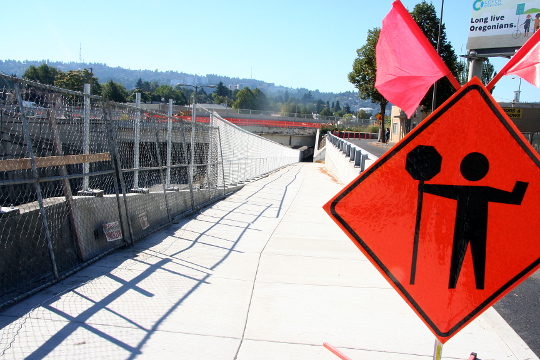
Here’s what the underpass, running parallel to Powell on its north side, looks like now:
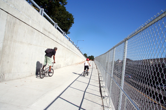
Here’s the ramp down to the underpass, seen from just east of the tracks and north of Powell:
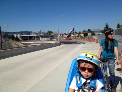
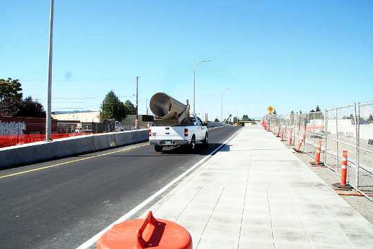
Here’s the overpass across Powell, as seen from its landing to the south near Pershing Street. Those are the future MAX tracks to the right.
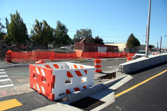
At the southern side of this overpass, people on wheels and feet are directed across a crosswalk that involves a semi-blind corner and what’s currently an uncomfortable pedestrian refuge. On the bright side, the crossing is well-marked and has a hand-activated flashing light.
Another feature worth understanding is intended to help people walking north of Powell efficiently reach the railroad underpass. It’s a narrow, steeper ramp, set off by steps at both top and bottom, that runs between the sidewalk above and the underpass. The steps, presumably, are there in part to keep this from becoming a blind corner for bikes:
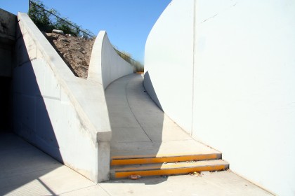
For bikes, the best down way to the underpass is
to avoid this ramp completely and
descend from street level more gradually.
TriMet spokeswoman Mary Fetsch (herself a longtime daily bike commuter from North Portland to TriMet’s office south of Powell) added a few more notes:
When they are striped, the designated bike lane on 17th Avenue will end around SE Pershing, and then northbound bikes go onto the multi-use path. There are no designated bike lanes on the structure. The designated bike lanes near SE Pershing have not yet been striped, but will be in the future.
Additionally, the new sidewalk is open on the north side of Powell under the overpasses (MUP width except under UPRR structure). Follow up work still happening, but it’s open and much improved over the crossing before construction began.
Hard to argue with that.




Thanks for reading.
BikePortland has served this community with independent community journalism since 2005. We rely on subscriptions from readers like you to survive. Your financial support is vital in keeping this valuable resource alive and well.
Please subscribe today to strengthen and expand our work.
“The steps, presumably, are there in part to keep this from becoming a blind corner for bikes”
What does ADA have to say about this?
I think ADA will say bust out the jackhammers.
You guys may know better than I do. I’ve added a second reference above to the fact that there are steps at both the top and bottom of the ramp, and that there’s an easy, though less direct, connection to the underpass from the street-level sidewalk that I assume meets ADA grade requirements.
Seems a bit sub-Platinum, based on the pics.
Those steps will break peoples’ collarbones, if not their craniums. They’ll also stop wheelchairs, stop moms with trailers and tagalongs. I assume there’s another way around?
Here’s the project diagram, showing most of the bridge.
http://trimet.org/pdfs/pm/stations/Station-Area-Plans/Clinton_SAP.pdf
and this one, showing the south approach to the bridge (the nice multi-use path in the cover photo?) http://trimet.org/pdfs/pm/stations/Station-Area-Plans/Rhine_SAP.pdf
The scales are different on the two diagrams, but it looks like the multi-use path connects the 17th & Rhone station north across Powell, nicely and seamlessly, which is a massive improvement from the previous crossing. But what’s up with the stairs?
Ted Buehler
ted, there is another way around, but it’s another two blocks away. this entrance is directly on se 17th, and it’s pretty non-intuitive to travel on 17th to this enticing ramp-like entrance and instead veer left and go the wrong way down a 1-way street to reach the actual entrance — or uturn and head to 19th to try the other entrance.
I’ll need to go down and see for myself, unless someone can produce the drawings. It’s such a complicated puzzle that I can’t figure out where the different paths are going based on the explanations given here.
se 17th, north of Powell, south of Powell?
Ted Buehler
Gosh, we’re all going to miss the bicycle traffic citations :^)
Steps as a shorter route option than the ADA route is fine. Like the flights of steps at the east end of the steel bridge to get from the lower deck up to street level.
But the “two steps at the bottom, two steps at the top” are not uniform with other similar “stair bypasses.” And they will be problematic operationally — 2 stairs are harder to see than a flight of stairs, and two sets of two stairs is pretty much unprecedented.
100 years ago, pre ADA, “Garden City”/”Olmstead” era parks often had steps here and there. Not so much anymore.
At the University of British Columbia the old main library had an Olmstead-era set of paths through the gardens. On one section, there were 2 paths, one had 2 steps, one had zero steps. When going through that part of campus I would take care to bike on the one without steps.
One night I was cruising along, abentmindedly, ended up on the wrong path, and just about slammed into those steps.
Take home message — it’s easy for 2 steps to disappear in your vision when you’re biking along. Better to have a whole flight of steps instead, as it has a more pronounced visual signature.
My $0.02
Ted Buehler
No handrail ? And hard to tell from the picture but the rise of the stairs appears to be less than 7″‘ both of which is code for public facilities. Though there might be an exemption with so few stairs on it. ADA requirements would be satisfied with the bike path for wheelchair use.
I agree that it’d be better as all stairs. I’ve got a feeling you’re going to have a hard time keeping the skateboarders off this. Looks like fun challenge and one I might have tried 20 years ago….
My guess is that it was kept most as ramp to keep people from sitting on it and loitering. Stairs make for a nice place to sit, a ramp not as much so.
But there’s still no way to get to 17th from east of the railroad tracks without taking Holgate or Bybee, right?
While I’m super pleased that this overpass is finally open, the lower crosswalk (closer to Pershing and 17th) has button-activated blinky lights, but the raised barrier obscures oncoming traffic until you make it to the refuge island. I couldn’t tell if that big concrete barrier is permanent; it’s like a highway median.
I was in Olympia recently and really liked the crosswalk LED’s that blink when activated. Does PBOT ever use those here?
Oh, one other thing. The steps face east. Riders from that area will either go down the little steps or come down the longer ramp. There’s no reason why a rider heading west would go up the steps, since they just came from that same block. I think this is designed so people zooming towards the east (aka, the same direction as the stairs) could never plow into them, because they’re facing the same way.
“Riders from that area will either go down the little steps or…”
Riders going down little steps is an action that results in broken clavicles and craniums. Just sayin…
Does anyone have a link to the 100% engineered design for the whole light rail project? The website has 90% engineered layouts of just the station areas, but thinks could have changed, and the sections between stations are not clearly available.
I would like to know if there will be a reasonably continuous route from SE 17th to the bridge, for people to use when biking from Brooklyn or Sellwood, and if there are paths along the tracks in other areas that might be useful.
They will be redesigning the crossing of 17th and Mc Loughlin with better crossing in mind. Not sure of the the specifics, but I know we talked of this on another tread fairly recently. I’m pretty sure it was in the comment sections about the garbage truck/bike collision last month.
I do remember looking at some PDFs about it and it looked pretty good. Though the improvements would stop at the crossing, you’ll be on your own south of Mc Loughlin on 17th.
I have a guess on the steps. They put them in so it’s obvious to those with mobility issues that the ramp in not intended for wheelchair users, as it is too steep. The stairs are a way of making that obvious, although it’s a little harder for cyclists using that ramp. Those using that would be the folks living north of Powell along 17th and other streets in that neighborhood, to access the new Max station, for instance.
“They put them in so it’s obvious to those with mobility issues that the ramp in not intended for wheelchair users”
Stands to reason.
But its still a poor design. There’s lots of things on wheels that don’t mind a slope > 5% (the legal limit for wheelchairs). Like:
* Bikes
* Bikes with trailers
* Cargo bikes
* Bikes ridden by people with low upper body strength who can’t heft their bikes up stairs
* Bikes laden with cargo whose riders can’t heft them up stairs
* Wheelchair users who can handle steeper grades
* Elderly folks with walkers
* Elderly folks who shuffle and don’t do stairs
I still say its a poor design decision to use potentially hazardous stairs to “mark” a route as being unsuitable for users restricted to ADA routes. They’ve unnecessarily made the route inaccessible to a whole host of other users who happen to lack any route engineering privileges whatsoever.
Ted Buehler
I just rode this, and it is a HUGE improvement over what we had before.
That said, it’s only my new second-favorite way to cross SE Powell. My new favorite way is at Milwaukie, now that we have full bike lanes all the way north to the railroad tracks and SE Clinton. Those 2-3 blocks were a pretty hairy stretch to ride through before, and now they are not. (It’s still not perfect, since the southbound bike box at Milwaukie/Powell was removed from the plan, but it’s incredibly better than before). Thank you TriMet!
(The reason Milwaukie is my favorite is mostly because 17th is on the other side of Brooklyn from me, so it’s a bit out of my way).
GlowBoy — how does the path cross the MAX tracks?
On the Clinton St. Station diagram, the path is between the road overpass and the MAX tracks as it disappears out of the south side of the diagram.
On the Rhine St. Station diagram, it’s between the MAX tracks and the freight RR tracks.
Does it cross at-grade? Over/under?
Just curious. Can’t find the official drawings.
Ted Buehler
Hmm … I don’t think it does cross the MAX tracks. The path runs along Powell at its north/west end, and towards the south/east it currently ends at Pershing street, still west of the tracks IIRC. Not sure what it will do to the south of Pershing.
Regarding the new intersection at 11/12 Clinton/Powell/Milwaukee: It looks like the planned new routes down towards OMSI from either SE Clinton, SE Milwaukee, or SE 17th will involve the use of sidewalks in order to cross SE 11th and 12th avenues at the 11/12 split. This new curbing is all finished now, and sports a nice “bikes use sidewalk” sign. It looks to be the permanent fix to anyone who wants to continue on the new bike path (not finished) which will parallel the light rail tracks from here town to water ave and under the 99E viaduct. Although there are lots of cross walks and painted arrows on the pavement, in addition to those (slippery when wet) yellow-bumpy traction pads at the curb ramps in this area, it looks to be a pretty big cluster of cars/peds/bikes/trains/maxs/buses. And, will involve sidewalk riding as you have to ride against the flow of one-way traffic on 12th (on the sidewalk) if you are coming from Clinton and then again against the flow on the sidewalk on 11th to continue towards OMSI. These are short little jaunts on the sidewalk – maybe 30 meters each, but upsetting since it will have other vehicles, bicycles, peds all moving in many directions at this new intersection design. Including 2-way cycle traffic on these sidewalks.
http://trimet.org/pdfs/pm/stations/Station-Area-Plans/Clinton_SAP.pdf
If you come into this area on 17th, or milwaukee, you can avoid one of the sidewalk jaunts, but you sill still have to cross 12th, then 11th, and then ride the sidewalk on 11th to get to the new bike path.
This looks to be a potentially dangerous intersection that will see many more cyclists and peds than before when the LRT goes through (plus add the usual cars/buses/trains) and will have lots of imaptient car drivers not wanting to wait for cyclists crossing on sidewalks. I think if you just want to keep riding N on 12th ave, then it will be great (no sidwalks, no difficult road crossings), but then you are riding on 12 th Ave. where the bike lane disappears…but if you want to use the new route, it will take some getting used to (and waiting for cars to stop and pedestrians to pass).
Its a whole tangled puzzle down there, I just hope that they’ve done a good job of providing bicycle access throughout.
Every TriMet trip costs a few public $ in operating costs, subsidized by all of us. Every potential TriMet user that can be enticed onto a bicycle because of infrastructure upgrades as part of the MAX line installation will save public budgets a couple $ a day forever and ever. If there’s, say, 250 potential TriMet riders that can be lured to a bike, that’s a savings of about $2/day, $400/yr/rider, or $100,000/yr in savings to the public coffers.
That should be powerful motivation to improve bikeways as they improve other forms of non-car transportation, but since the costs and savings come out of different public budgets, they never look at the problem this way.
Ted Buehler
Here’s a link to (sideways) plans for this intersection area…
ftp://ftp02.portlandoregon.gov/PBOT/PMLR%20-%20UPRR/UPRR%20At-Grade%20Crossing%20Agreement%20-%20SE%2011th%2012th.pdf
It looks as though bikes heading east from OMSI to Clinton will use the bike lane across the tracks on 12th, while bikes headed in the other direction use the sidewalk.