
The newly completed Rosemont Trail, a paved path that connects downtown Lake Oswego to West Linn in Clackamas County, should be cause for celebration — except for that fact that bicycling is banned on about half of its entire length.
After The Oregonian covered this story yesterday, we got several emails from readers who were disturbed by this lack of bicycle access. The ban is especially unfortunate given that the adjacent Rosemont Road is a narrow, high-speed thoroughfare without wide shoulders for bicycling on. According to The Oregonian, many people expected the path to allow bicycling, and there is considerable consternation now that it doesn’t. Hoping to better understand the background and context of this project, we reached out to Clackamas County and the group who paid for and created the trail, The Columbia Land Trust.
According to Clackamas County Transportation Engineering Manager Mike Bezner, there was never any intention of allowing bicycles on the path. “The [Oregonian] article was misleading… It was never intended to be a bike path,” he shared in an interview this morning. Bezner, who made it clear this was not Clackamas County’s project, said the project had been planned without bike access in mind since 2006.
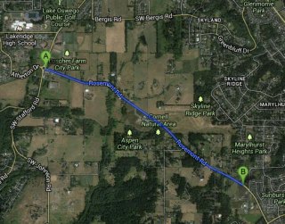
The reason for this is because when the Columbia Land Trust obtained the initial permits for the project in 2005, they could only afford a six-foot wide path. That’s too narrow for a shared-use path, says Bezner. “They did the project with that mutual understanding all these years.” Bezner also said that permits for the project include only “pedestrian easements” that specifically prohibit bicycle riding. “The people that live along the route didn’t want to give them easements for bicycles.”
The fact that the Columbia Land Trust ended up building this last section of the path eight feet wide (not the six that was originally planned), doesn’t sway Bezner’s decision. He said this morning that in some cases they could make eight feet work for a shared bicycling and walking path (they prefer 10 feet); but in this case, the topography of the area makes it unsafe for shared use.
“The people that live along the route didn’t want to give them easements for bicycles.”
— Mike Bezner, Clackamas County Transportation Engineering Manager
The section of the path in question is relatively steep and the main concern from the County’s perspective is safety. Bezner claims, “There’s already been a lot of reported bike and pedestrian near misses — including the reporter who wrote that article in The Oregonian. She almost got hit by a bike.”
Jill Davis, communications director for the Columbia Land Trust (CLT), agrees with the County’s safety concerns. She also concurred with Bezner’s history of the project, and said The Oregonian story was inaccurate*. The Oregonian reported that the CLT “from the beginning called it an amenity for both cyclists and pedestrians. It even widened the trail from the planned 6 feet to 8 feet to accommodate bikes.”
“Columbia Land Trust never promised that it would be open to bikes,” Davis shared with us today, “This sentence in the Oregonian is factually incorrect… Allowing bikes was never a guarantee. We cannot find any outreach materials that ever promised the Rosemont Trail would be a bike trail.” (*UPDATE: Davis now says that CLT’s Executive Director who was quoted in The Oregonian story, “inadvertently mischaracterized the history of the trail to the reporter”.)
As to why her group widened the trail from six to eight feet, Davis says that was done in order to “possibly” accomodate bike access “at some point in the future.”
Both Bezner and Davis say they’d ideally like to see bicycling on the path, but they each had a different outlook on whether or not that’s likely to ever happen. Davis says her group plans to collect data about how the path is being used then present it to the County in hopes of finding solutions to the “safety issues inherent on the Trail.” “Columbia Land Trust’s goal is for the Rosemont Trail to be usable by both bikers and pedestrians, and we will continue to work toward that end.”
But Bezner, although he says bike access on the path would be ideal, sounded less hopeful. “We are trying and actively working on this, but I don’t see an immediate solution,” he said. “I can’t make it wider and the easements don’t accomodate bikes. I just don’t think we’re going to have a solution that is going to get bikes on it any time soon.”
Clackamas County’s long term plans are to install bike lanes on Rosemont Road; but Bezner says improving bicycle access on Rosemont — whether it happens on the road or on the new trail — isn’t a high priority for the County right now. “It’s one of about 400 projects on the list,” he said, referring to the current update of their Transportation System Plan. “There is a lot of competition on that list. A lot of good projects.”
—
While there are surely a lot of other needs and projects on the County’s list, I doubt any of them can boast of $1 million in private investment that has led to a major new piece of infrastructure already on the ground. Not to mention one that prohibits bicycle use and perpetuates a lack of a safe bicycling connection where there could easily be one. Whether or not these facts move future bike access improvements in the Rosemont corridor up the County’s official priority list remains to be seen.


Thanks for reading.
BikePortland has served this community with independent community journalism since 2005. We rely on subscriptions from readers like you to survive. Your financial support is vital in keeping this valuable resource alive and well.
Please subscribe today to strengthen and expand our work.
Thanks for the coverage, Jonathan. Very interesting situation. I’m keen on watching this unfold.
Isn’t this essentially a sidewalk? bicycles are generally allowed on sidewalks. What gives here?
I would hate to head down a path where every strip of pavement/concrete has its own rules. consistency is important. Obviously, bicycles need to yield to pedestrians in certain situations, but banning just strikes of unfounded fears.
Bicycles aren’t prohibited from sidewalks by ORS, but there are many examples of prohibition via local ordinance throughout Oregon cities for the safety of pedestrians (particularly where there are many shops, like in downtown Portland).
If speed-related steepness is a problem, I wonder if a potential short-term compromise might be to allow people riding uphill to use the trail, since the downhill traffic could presumably find it easier to ride with traffic.
Not ideal–the ideal would be to have both directions use a separated trail, of course. Given the speed on Rosemont, it still wouldn’t be safe for families to take the lane on the downhill. But it would be an improvement until a more permanent solution could be found (such as raising more funds to widen the trail).
Somewhere in this tangle is a bureaucrat (or several) that has a chip on their shoulder. Pretty lame.
As highlighted in the piece it seems like the main reason bikes are not allowed is that the land owners who gave or sold the easements did want cyclists. This may be based on misplaced fears but don’t blame local public servants for this.
As noted by Allan above, since bicycles are allowed on sidewalks, what exactly is the basis for exclusion here? Or more specifically, what is the legal basis for exclusion.
The Oregonian article said police could ticket cyclists for using the path. But for what? Just because you put a sign up there doesn’t mean that things on the sign are law. There has to be an actual statute or ordinance backing it up.
Sidewalk exclusion in downtown areas in Oregon are all local ordinances. You can look at them all on a single page.
Are they going to call this a park and use park rules to control the traffic modes?
There may be reasons to allow or disallow certain kinds of traffic but if this path is in the public right of way, they may have a hard time excluding bicycles since bicycles are allowed on virtually all other pedestrian facilities.
ORS 810.020 Regulating use of throughway. (1) Each road authority may prohibit or restrict the use of a throughway in its jurisdiction by any of the following:
(a) Parades.
(b) Bicycles or other nonmotorized traffic.
(c) Motorcycles or mopeds.
(2) Regulation under this section becomes effective when appropriate signs giving notice of the regulation are erected upon a throughway and the approaches to the throughway.
(3) Penalties for violation of restrictions or prohibitions imposed under this section are provided under ORS 811.445.
(4) The Oregon Transportation Commission shall act as road authority under this section in lieu of the Department of Transportation. [1983 c.338 §146]
810.030 Imposition of restrictions on highway use; grounds; procedure; penalties. (1) A road authority may impose restrictions described under this section on its own highways as the road authority determines necessary to do any of the following:
(a) Protect any highway or section of highway from being unduly damaged.
(b) Protect the interest and safety of the general public.
(2) Restrictions that may be imposed under this section include any of the following:
(a) Prohibition of the operation of any or all vehicles or any class or kind of vehicle.
(b) Imposing limits on any weight or dimension of any vehicle or combination of vehicles.
(c) Imposing any other restrictions that the road authority determines necessary to achieve the purposes of this section. This paragraph does not grant authority to impose speed restrictions.
(3) Any restrictions or limitations imposed under this section must be imposed by proper order. The restrictions or limitations are effective when appropriate signs giving notice of the restrictions or limitations are erected. A sign giving notice of a restriction or limitation in an order shall be maintained in a conspicuous manner and shall be placed at each end of the highway or section of highway affected by the order and at such other places as is necessary to inform the public.
(4) Penalties are provided under ORS 818.130 for violation of restrictions imposed under this section. [1983 c.338 §147; 1985 c.16 §46]
Reading this statute it appears that they CAN restrict access by mode. But I have to wonder if there are restrictions on its use with regard to bike somewhere else in the vehicle code.
If local governments could do this unrestricted you would think that there would be some place in the state that it be done. Some bicycle hating city council would put this to use.
But as far as I know this isn’t happening. So, is there something else going on here in terms of who gets to set the rules regarding mode restrictions?
Not applicable – “throughway” only applies to roads. See http://www.oregonlaws.org/ors/374.010
“throughway means a highway or street especially designed for through traffic” – it has a very specific state definition.
Also see http://www.oregonlaws.org/ors/801.524, which is the applicable statute to vehicle laws.
ORS 801.524 “Throughway.” “Throughway” means every highway, street or roadway in respect to which owners or occupants of abutting lands and other persons have no legal right of access to or from the same except at such points only and in such manner as may be determined by the road authority having jurisdiction over the highway, street or roadway. [Formerly 801.535]
This applies to any road.
They have been actively soliciting donations and they still are. It bothers me that their website where they are asking for money clearly states that the reason for the trail is to improve bicycling as well as pedestrian conditions, i.e. if you like to bike give us money but at the same time it does not mention that the trail will not allow cyclists. Seems kind of disingenuous.
Here is a quote from their site:
Why the Rosemont Trail Matters: Rosemont Road, where the trail is being constructed, is a narrow and busy county road with no room for the pedestrians or cyclists that use it to access local parks and open spaces. Further, the county has no plans or funding to improve or widen this road. The Rosemont Trail will provide a safe way for the children, families and residents of Lake Oswego, West Linn and the surrounding areas to safely access these parks without having to get in their cars. Ideal for walking, jogging, dog-walking and even bird-watching, the trail crosses a rural area of Clackamas County, offering a bucolic, agricultural setting minutes from urban centers.
I noticed that mention of cycling on their website too Bjorn. However, keep in mind that about half of the trail is open to bikes. Also, in the specific reference to cycling that you cite, they state that bike conditions are bad on Rosemont Road, they don’t say explicitly that the new trail will be awesome for biking. I know it’s splitting hairs somewhat; but it’s important.
Six feet is considered fine for bike lanes on roads. Obviously the decision to prohibit bikes is not one based in fact or reason. The best solution would have been some friendly signage to share the path with other users. Like on the esplanade. It’s not that complicated, and how many people a year in the US die of bike/ped collisions? Deliberately makes biking less safe by forcing them on the roadway. Apparently nothing is too insignificant in Clackamas County to be turned into political hay.
I agree that bikes should be allowed, however, your example of the Esplanade is fraught with problems: The Esplanade is quite a bit wider, and cyclists have proven to be pretty big jerks there! Not all of them, of course, and no fatalities that I know of, but enough to seriously compromise a nice place to walk. Some cyclists have a VERY hard time slowing down, and though I am an avid commuter, I can see their point that bikes and peds on an 8-foot trail could have problems.
Please, don’t complain that cyclists are jerks when groups of 4+ pedestrians feel the need to walk side-by-side and take up more than half of the path. Or the oblivious tourists in their rented surreys from Kerr Bikes blocking the path.
The blame goes both ways.
I think it’s been well-established that “people” are jerks – whether on feet, on wheels, or in an enclosed conveyance. (some people, anyway)
But the Esplanade also has exponentially more pedestrian traffic than this path does/will.
6 feet wide for single-direction bike lanes, not contra-flow paths.
Many of the paths connecting Naito Parkway(also the Hawthorn Bridge off ramp to the park) to the Waterfront path are only regular sidewalk sized (4′ I think). Steel Bridge path isn’t more than 6′ either.
And I’ll bring a tape measure with me next time I’m on the 205 path as well. But I’d guess it’s only 6′ in many places.
The Steel Bridge path is 8′ from rail to rail. The I-205 path is at least 8′ as well. That’s was the minimum standard width for 2 way bike/ped paths when these were constructed circa 1980’s (I-205) & 1990’s (Steel Br.).
Oh great, now that a paved trail lines the road, drivers will be shouting at the cyclists to ‘use the f ‘in trail’ when cyclists are not allowed. Bone-heads. The lot of ’em.
I can see drivers becoming irate as public funds are used to build a trail prohibiting cyclists that is mostly devoid of pedestrians anyway. What do they expect this trail to become, the next pedestrian dense Eastside Esplanade?
Just ride on it, already. When enough people do that for long enough, it’ll become a de facto bike route. Does anyone really expect any sort of enforcement action? The cops have plenty of bigger crimes to go after.
Yeah, that’s what I thought too. I guess you could just stop and walk your back the few yards through the banned section. But this strikes me as one of those perfect opportunities for civil disobedience.
As one who had my share of tickets for participating in Critical Mass, my guess is the cops will use this trail as a source of revenue enhancement for their cities and selectively enforce the statute for targeting persons who don’t ‘belong’.
Clackistan 1, Bicycles 0
really? It’s only 1-0?
Clackonics
If an entity builds something that looks for all the world like an MUP yet maintains that it’s “not really” an MUP (yet), seems like the entity might open itself up to significant liability.
It seems that taking the lane on the slow uphill route is what the county prefers… Dozens of small-scale Critical Mass events each day…
Oh… so the signs are for legal liability ass covering, in case a bicycle runs into a pedestrian. Ahhh, I get it now. This has nothing to do with actually managing access.
Clackamas sheriff is the only entity that could enforce this as all of that portion of trail is outside west linn and lake oswego city limits. And I doubt the county sheriff gives a hoot.
Lets talk numbers. Actual numbers. How many pedestrians per hour use this path? Is the density of pedestrians so great that cycling could pose a hazard? Essentially, are there any FACTS behind this decission?
“Potential near miss” doesnt cut it. The definition of a near miss is that nothing happened. If we’re banning things due to near misses, then we need to close every road to cars, effective immediately. Sidewalks too. People have near-miss walking disasters all the time. Hell, just yesterday some scoffaw three year old came THIS CLOSE to running into my leg. We need to ban that.
Rosemont trail…A project that has taken land, overlayed it with blacktop, and, due to our beautiful beaurocracy; accomplishes nothing in the process except displacing a bit of urban wildlife and given 3 pedestrians/week a safe place to walk (during daylight hours).
$1mil to will feed a lot of hungry mouths…Or shelter a lot of individuals in need…But I’m sure glad it was spent on a project with such lofty goals…Aye! (<—sarcasm, if you couldn't tell)
One thing to note is the number of driveways and roads that intersect with the path. There is concern that drivers turning in and out of these would not see a speeding bike coming down a hill.
I propose that any pedestrians or automobiles caught in a bike lane should have their vehicle impounded and spend 24 hours in jail.
See Clackastan, we can be petty and spiteful too.
And truth be known there are some fairly bike critical MUPs that are needed by cyclists to get safely to and from our jobs and shopping made hazardous only by pedestrians who seem to think that MUP means “camp chair beer keg party zone” or “stumbling randomly and stopping suddenly in front of safely operating bicyclists zone”
If you wack-a-doos can make this PUBLIC RIGHT OF WAY illegal to bicycle on there is no legitimate reason we cyclists can’t take the gloves off on the issue of non-bicycle use of bike lanes.
<pant>, <pant>, <pant> rant over.
When the rage recedes the urge to violence will be gone but I’ll still think these “people” need to be strapped down Alex from Clockwork Orange style and be shown civics movies explaining what common public areas are and why we have them.
Is this trail part of the original master plan from 1991?
http://www.ci.oswego.or.us/parksrec/pathways-guide
“The system was established to enable residents to travel safely by foot, bicycle, or in-line skates. Users are invited to enjoy the scenic beauty of Lake Oswego on the many miles of tree-lined, interconnected, paved pathways while getting beneficial fresh air and exercise”
If so, it sure seems like someone dropped the ball to me…
The following master plan for this area mentions bicycles many times..
http://www.ci.oswego.or.us/sites/default/files/fileattachments/parksrec/cityprojects/13440/councildraftluscherareamasterplan062513smallsize.pdf
If this is the plan refered to in the article, everyone should load it and ctrl+f “bicycle” and “bike”.
Roughlly 16 refrences most not imporant (bike racks on maps etc…), but one section titled: “ROSEMONT MULTI-USE TRAIL” (pages 86-87) specfically states that:
“The Rosemont Trail connects park facilities
along the Luscher Area’s site perimeter. The
Rosemont Multi-Use Trail makes it easy for
park users to park at any of the Luscher Area
parking lots and access the rest of the site by
foot, or by bicycle on the paved portions”
Though in all fairness, this document also says the trail isn’t part of “this plan”(or at least part of the cost considerations. And I quote:
“Although the Rosemont Multi-Use Trail is not
included in the cost estimate in Chapter 7, it is
important to consider how it functions on the
site and what kinds of future improvements
may be necessary” – (page 86)
Seem to me reguardless that Lake O was under the impression that trail was designed as a MUP.
Tell that to the cop who gives you a ticket for violating ORS 814.420 for riding in the road next to this path.
Is it actually open to bikes if it already shows up in the Google Maps bicycle layer…?
I guess cyclists know who not to donate money to.
funny. I thought this trail was built for bicycle use because of the fact that twisty rosemont is dangerous to ride. walking has always been possible on the natural shoulder. i am riding this one.
I ride Rosemont on a regular basis (always downhill) and when the trail opened I assumed it was OK for bikes and rode it–once. Trust me, no downhill cyclist wants to stay on that trail for long. It has many pitches, dips and angles and intersects blindly with many long driveways 10 feet off the road. I’ll continue to take my chances on Rosemont proper and don’t plan to ride on the trail ever again whether or not it is legal. It’s way too dangerous.
This. Take the lane on Rosemont, especially downhill.
Two words: Skate Boards!
I can understand the safety concern.
But why not have a 10mph speed limit similar to the south west portion of the waterfront trail? Then if some people are riding recklessly you can give them a ticket, otherwise if people are being careful its fine.
It would seem to be less of an issue if it were safe for bicycles to ride on the adjacent road.
Ed
Hmmm. If someone misstated the project’s history to a reporter at the O, then they’ve been doing it for a long time. I covered this project for years as a reporter for the Lake Oswego Review and I was also told that this was a shared use pathway.
Can we walk our bikes on the trail? or fill them with helium, and float ’em over our heads?
I drive Rosemont everyday and it is unfortunate to see that hardly anyone is using this trail now that they have such limits on it. What a waste of so many much money by excluding bikes. Rosemont is too dangerous to ride a bike on for most. It is just far enough away from the neighborhoods so you don’t see families with kids walking on it even. This was supposed to be a way to link two cities together.
The Port Authority of NJ & NJ operated Pedestrian / Bike paths on its bridges – The George Washington Bridge’s Path is 6’7″ wide.