Recent coverage and reader comments on the North Portland Greenway here on BikePortland have not been kind to the project. While I think we have good reason to be disappointed in the southern two segments of the “near term buildable” alignment being proposed by Portland Parks & Recreation, we shouldn’t overlook the exciting plans for the northern segments.
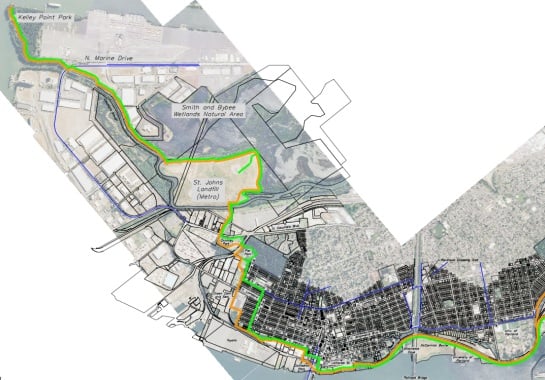
Parks planners have split the greenway alignment up into five segments. The segments take the path from way up north in Kelley Point Park (just feet from the Columbia River) all the way south to the Steel Bridge. The reason folks are upset at Parks is because, starting with Segment 4 (Swan Island), they’ve chosen to deviate from both the vision laid out by the npGreenway non-profit group and from the City’s already adopted North Reach River Plan. But for now, let’s focus on the three northernmost segments.
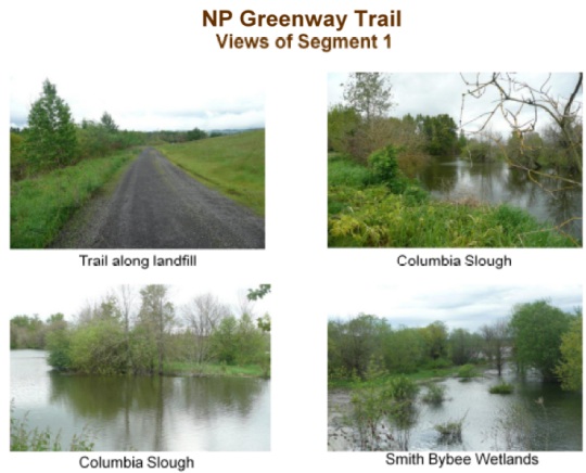
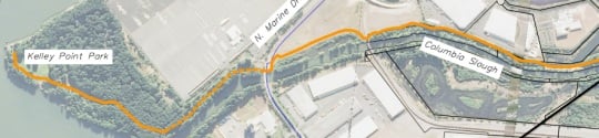
In Segment 1, Parks will improve the existing paved path in Kelley Point Park and then head south, across N. Marine Drive to connect to the existing portion of the 40-mile Loop trail. The route would then continue south along the Columbia Slough. After going behind a few industrial buildings, the path would slice between the slough and the Smith and Bybee Wetlands Natural Area. This will be a very picturesque place to ride! Continuing south, the path will go along the perimeter of the Metro-owned St. Johns Landfill (an old dump now converted to natural area) before crossing over N. Columbia Blvd. (And yes, Parks is considering a significant crossing improvement over Columbia.)

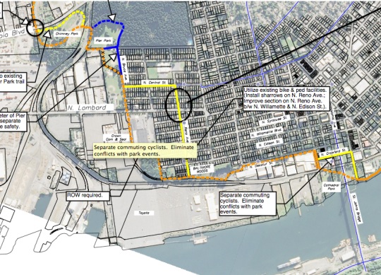
Segment 2 takes us from Columbia Blvd to just south of the St. Johns Bridge. South of Columbia Blvd, the route weaves through Chimney Park and Pier Park (over a soon to be built bridge) before heading through residential neighborhoods in St. Johns. Sharrows will be added to N. Central and Reno avenues and the route will head west use the existing signalized crossing of N. Lombard. The route then turns south at Baltimore Woods to make the connection to the bridge.

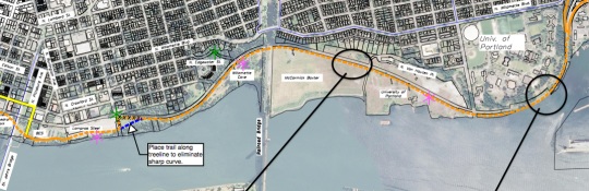
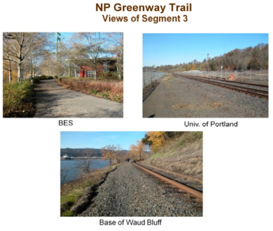
Onward to Segment 3 and we finally get the path along the Willamette River. The path winds south through several old industrial sites and adjacent to railroad tracks before coming to University of Portland-owned land and the base of Waud Bluff. The path will be 14-feet in most parts of this segment (18-feet if you count the two-foot curbs). The base of bluff (the point on which U of P sits) is narrow so the current plan calls for an elevated, 12-foot wide path with railings built directly into the river. From the bluff, the route would connect onto Basin Avenue on Swan Island.

After Segment 3 we’re onto Swan Island and that’s where the problems start. We’ve covered those section of the route in the past, so I won’t repeat it here today. For more on this project and to see PDFs of all the graphics used in this post, see the City’s North Portland Greenway Trail project page. The official comment period for the alignment feasibility project ended yesterday, but you can still contact project manager Emily Roth with questions and feedback via emily.roth@portlandoregon.gov.


Thanks for reading.
BikePortland has served this community with independent community journalism since 2005. We rely on subscriptions from readers like you to survive. Your financial support is vital in keeping this valuable resource alive and well.
Please subscribe today to strengthen and expand our work.
I like some of the parts of this
Jonathan,
thanks for your ongoing coverage of this trail! I am a passionate of supporter of this trail, and I completely agree that sections 1 and 2 will be valuable additions to Portland’s recreation and transportation system. However, section 3 is cool, and very connected to the river, but it terminates in a GIANT STAIRCASE! That is very uncool (and possibly illegal considering ADA requirements) for anyone using a wheelchair, a stroller, a bike, etc. Furthermore, section 4 would allocate money and energy creating a near-permanent, dangerous and unpleasant route along Greeley. The team completely dropped the ball on section five, saying the Rose quarter redevelopment plan would fix it. Not true! The North Portland Greenway Trail NEEDS to show the alignment through the Rose Quarter AND a concept for connecting to the Esplanade so the Rose Quarter planning can incorporate those ideas. In my opinion, includeing the recommendations for Sections 4 and 5, and not addressing the stairs on Waud Bluff, in the final report will actually do more long-term harm than good. I believe that the Parks Department has done a great job of showing an alignment from Kelly Point to the University of Portland, and they should simply end their report and recommendations there.
maxd,
I hear what you’re saying and I too and disappointed at the massive stairs on the Waud Bluff Trail… But I was tracking the trail from north to south and I don’t think you’d have to use the stairs unless you were coming down from Willamette Blvd. Am I right?
I hope you are right! The plans provided for section 3 and section 4 show this piece of trail differently, but it doesn’t make sense that if the cantilevered stretch below UP is between the river and the tracks, one would not need to cross the tracks at the Waud Bluff trail.
You are pretty well-versed in these plans, do you think it will be a mistake for the long-term prospects of this route to neglect showing a conceptual connection to the Esplanade below the Steel Bridge?
Does anyone know the feasibility of a trail going around the west side of the St John’s landfill? Seems like a bit of an indirect detour.. maybe in the longest term plan?
Josh G,
Good point! There is an existing gravel service road that circles the base of the landfill. It seem worth the relatively small expense to pave the whole rout and give people the option to go either way around!
Parks does parks very well, they just have problems with transportation. From the west side of the bluff at Univ. of Portland, to Kelly Point,it is a pretty good recreational trail with good neighborhood connections. The only major beef is trail width, but with the bridge connection between Pier and Chimney Parks and a safe crossing at Columbia to the former landfill, and a bridge across the slough, it will be a great trail. Folks will drive their cars from miles around to enjoy the trail.
But folks riding there from the Esplanade and lower east side …thats what the carping is about. Because it is primarily a transportation trail to connect the jobs and neighborhoods in North with the rest of the city.
I just have to add that the Springwater was built as a rec trail, but its utility made use increase exponentially since the connection across McLoughlin to the river and then downtown. npgw stands to see that same, if not more use when safe connections are made to the esplanade.
I’ll go back to sleep now. Thanks.
Joe, I couldn’t agree with you more. I work in Rivergate and live in SE, and have a hard time imagining I will use the new trail as a commute option, since it will certainly be much slower and longer than the relatively straightforward Lombard – Willamette Blvd – Greely/Interstate – Esplanade route. And, it’s hard to imagine anyone out for a nice park-stroll/cycle on the new NPGW at Smith/Bybee/Landfill trying to cross Columbia Blvd at Chimney Park – that is a section of highway which is a daily death race between truckers hauling containers and junk metal recylcers coming over a blind hill and going into a blind corner (blind at the speeds travelled) at that point. I might use the new chimney park bridge and take my chances on the sidewalk on Columbia to get to Rivergate, but only if the currently re-building project for N. Burgard Bridge work doesn’t include a bike lane addition. N. Burgard still seems a better option to get to Rivergate/Kelly Pt than the 1/2 mile on Columbia – traffic speed and volume is much more reasonable.
The NP Greenway trail might be a nice commute option that I’ll use once in a while when I have an extra 15 minutes to add to my one-way commute. But, the elevated path seems pretty expensive and I wonder about funds for future maintenance – I wish they could find similar funds to improve the quality of Willamette Blvd bike lane surface and width and extend striping North of Ida to Richmond. The comments about the width of this raised trail are very key to us commuters, since we all know of the problems of the Esplanade – not just the width, but “pinch points” like benchs, public art, utility poles, garbage cans, tree planters, etc – all of those items need to be streamlined to avoid endless conflicts between trail users (3-abreast joggers) and cyclists.
There are definitely some important details to be fought for on the northern section. I covered the Bicycle Transportation Alliance’s concerns about them (the Waud Bluff Bridge, neighborhood connections, and the St. Johns on-street portion) as part of our September blog post calling for the Cement Road alignment. http://bit.ly/XDqvqK
That is a good summary of the shortcomings of this proposal. This team has been hearing a lot of public concerns, but they are not doing a very good job of addressing them! I tried to review the public comments on the Parks website and was frustrated to find that, although they transcribed the comments from the May openhouse, they simply offer a vague and glossed-over summary of the comments received at the September openhouse. I am assuming that these comments are public record, does anyone know how to access them? I would love to see what the public actually submitted to Parks in September, and after this last openhouse.
Interesting. The route with the varied types of areas that it goes through and likely the challenges really remind me of the Central Valley Greenway in Vancouver.
I am concerned that the trail is still not wide enough. The structure in segment 3 is only 12 feet wide, not wide enough if you want so stop and view the river happenings and still leave room for 2-way bicycle traffic and pedestrians. In previous open houses it was 16 feet wide but has now been narrowed to 12 feet. I guarantee you only get one chance to build a structure and trail like this and you better make it wide enough for all the future users.
In Segment 1, the portion along the Slough between N Marine and the landfill, does anyone know who this portion of the trail will be constructed? The trail there now is so broken up from sitting on top of marshy land, I’m wondering if they are going to pave it again, or if it will be elevated? The current trail is also underwater a lot of the year.
That was a displaced “w”. Meant to read “how”, not who.