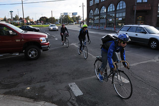
We can and should do better.
(Photo © J. Maus/BikePortland)
I won’t be satisfied with Portland’s progress as a bicycling city until our transportation system provides the same level of safety, efficiency, and respect to people on bicycles as it does to people who drive or take transit.
I can walk to my car and drive to my office downtown in a few minutes, enjoying comfort and safety on streets made just for me. Or, I can walk a few blocks to a bus or a light rail train and have a similar experience. But on my bike, my experience is vastly different.
Contrary to popular belief, bicycling in Portland isn’t all unicorns and rainbows. Cars still dominate the streetscape. In fact, there isn’t a single A-to-B route in this city that has the type of dedicated, connected, safe, easy-to-use facilities like we provide for motor vehicles and transit.
Is it really any wonder that well over 60 percent of Portlanders still drive alone to work everyday? (Or that a mayoral candidate saw fit to do it in an election ad?)
This is the place I started from when GOOD asked me to come up with an urban challenge for Portland as part of their GOOD Ideas for Cities project.
Katrina Johnston, me.
Back in February, GOOD teamed me up with the savvy trio of urban planners at THINK.Urban, a non-profit that melds academic research to urban planning. Over the course of several weeks, Jason King, Allison Duncan, Katrina Johnston, and I rolled up our sleeves and came up with a new way of thinking about our street system. (Actually, they did all the real work and I just spouted off crazy ideas at a few meetings.)
Below, I’ll share the basic points of our approach and then I’ll share some visual highlights from the presentation.
—
They key principles of re-making our system so it does a better job serving cycling is to make it connected, safe, and legible. If we do these three things we’ll get more capacity from the system for less money and we’ll reap the myriad benefits that come with more people choosing to ride bikes.
Connected
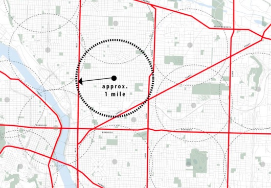
When we looked at a map of Portland, the most direct and accessible streets were all streets that either lacked quality bike access or lacked dedicated bike space completely. Streets like Sandy, Powell, Broadway, MLK, Lombard, and Burnside. For various reasons, we just assume those roads are primarily for motor vehicles and everything else should either steer clear or simply “be accommodated” only when and where it can be done without impeding motor traffic. That’s unfortunate. So, instead of a backstreet approach, we decided to do the opposite: Re-allocate space on these key main streets so they include quality access for all vehicles.
Safe

(Photo © J. Maus)
There is no mystery here. To encourage ridership and prevent collisions, we must separate motor vehicle and bicycle traffic. If we build streets for cars and trains and then try to figure out how to “accommodate” bikes, it will take us many years to see large jumps in bike usage. There are many tools engineers can use to create separation of modes. We don’t lack the knowledge to do this, we lack the political will.
Legible
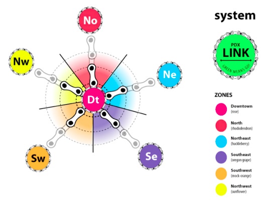
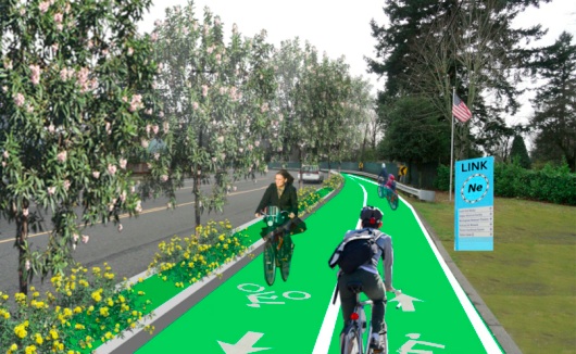
A great bicycling city shouldn’t require bike maps. People should not have to have insider knowledge just to move around the city on a bike. It should be blatantly obvious how to get somewhere safely on a bike — just like it is for driving or taking transit. That being said, it’s important to communicate at the street-level with a consistent brand. Just like it’s easy to spot a sign for a freeway on-ramp from blocks away, we should make it easy to find (and stay on) major links in the bike network. To accomplish this, Katrina Johnston developed a simple “LinkPDX” visual standard to tie the system together.
—
To give these ideas a whirl in real life (well, OK, this is a planning exercise, not exactly real life, but you know what I mean), we decided to develop a test route. Our route takes us from the Cully neighborhood in northeast Portland to Portland State University downtown. Not only did this route allow us to test many of our ideas, it’s also symbolic because it ties together two of Portland’s marquee — yet woefully disconnected — cycle tracks on Cully Blvd and on SW Broadway (near PSU).
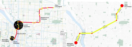
With our system you’d take only five streets to make this trip: Cully, 57th, Sandy, Burnside, and Broadway (see image above right). There are only seven turns to navigate along the entire 5.5 mile route. On the flip-side, if you took Portland’s existing bike network, you’d have to add 1.5 miles and make 33 turns! When you combine this inconvenience with risky gaps and broken connections, you start to understand why Portland still has a lot of work to do.
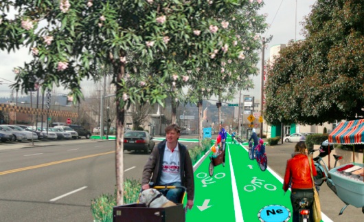
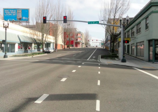
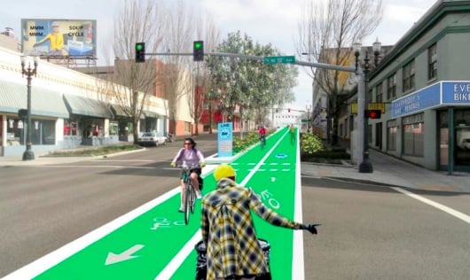
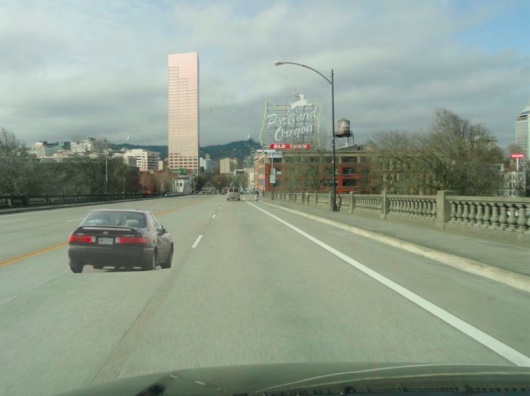
Below is a series of illustrations created by the THINK.Urban team that take you through the route…
NE 57th before
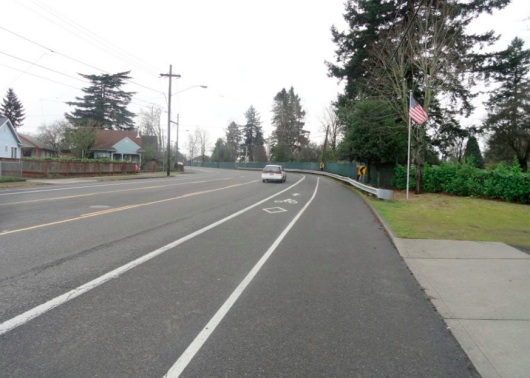
NE 57th after
NE Sandy before
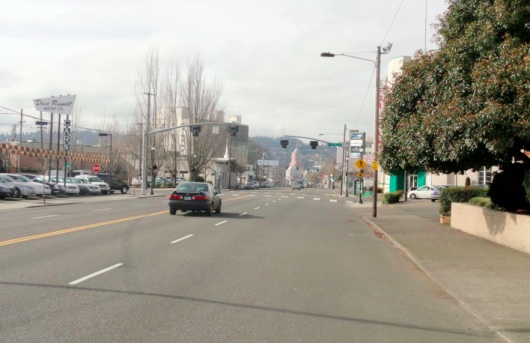
NE Sandy after
Burnside before
Burnside after
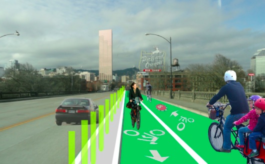
Burnside Bridge before
Burnside Bridge after
SW Broadway before
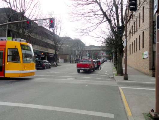
SW Broadway after
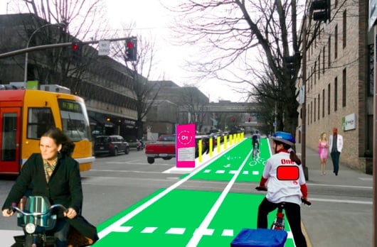
Before you nitpick these designs, understand that our team was made up of planners and dreamers, not engineers and bureaucrats. The goal is to spur conversation and show what might be possible if we think beyond the status quo. We have the backbone of a high-quality, connected bike network already in place. We simply have to use it better.
Thanks to Jason, Allison and Katrina for their excellent work in turning our ideas into a cohesive project and thanks to GOOD for the opportunity. You can view the entire presentation, including a video of Allison and Jason presenting it live back in February, at ThinkUrban.org.



Thanks for reading.
BikePortland has served this community with independent community journalism since 2005. We rely on subscriptions from readers like you to survive. Your financial support is vital in keeping this valuable resource alive and well.
Please subscribe today to strengthen and expand our work.
I cannot express enough how much I would like to see this vision realized up and down Sandy BLVD.
Unfortunately, our best opportunity has just come and gone. They are repaving Sandy right now, so I doubt they will pay any attention to it for the next 20 years.
Rock solid, now all we need is to pass the policy, secure the funding, and build the political will to make it happen.
I hear you Gerik. In my opinion, the first order of business is to get people excited about a clear vision for our transportation future (something the Bike Plan failed to do unfortunately). We do that with words and pictures… and then the politics and the funding fall into place much more easily.
Nice inspired thinking. As much as I like the “greenways,” I think we have taken our eye off the ball by ceeding major streets to autos. Bikes belong everywhere.
Yes, let’s do it. And let’s also anticipate the Beth Slovics by noting that this expenditure is defensive, is necessitated by the overwhelming dominance of the car, and not as she would have it, frivolous spending on nonessential stuff.
“If we build streets for cars and trains and then try to figure out how to ‘accommodate’ bikes, it will take us many years to see large jumps in bike usage.”
I would add to this that if we peel off bits for bikes incrementally without a long term plan that anticipates that cars are not going to be the dominant incarnation of mobility forever, it will be a bumpier ride.
I still don’t understand how people can consider bicycles ‘nonessential.’ If you aren’t creating space for bicyclists, then you have to create space for those people to be in cars. Car space is more expensive than bike space.
That’s really all there is to it. It’s like the anti-bicycle people just really like wasting taxpayer money.
I think the people you are imagining don’t understand/recognize/allow themselves to acknowledge people on bikes as also having somewhere to go. (Some of them) still appear to think people on bikes are out smelling the flowers or getting exercise rather than that they are legitimate commuters, or that this is just how they get around.
This was a huge part of why we chose the “no backstreet solutions” concept that we did. We all have places to go, and just because we are on a bike that doesn’t make them any less legitimate or important. And routing bike routes several blocks from the places we need to get to without access to those commercial centers (or whatever) makes no sense whatsoever. There is a reason certain roads are busy (arterials) and that’s because they take people directly and efficiently where they need to go.
“Car space is more expensive than bike space… It’s like the anti-bicycle people just really like wasting taxpayer money.”
This. A bazillion times this. With budgets shrinking, how can the city NOT repurpose roads to bikes? To do otherwise is throwing good money after bad.
Addicts hate to admit their problem.
This is great! I’ve been commuting from cully for a year now. Wish this route existed right now, I’ve done the sandy route before, and it sucks.
The example photos would make it awesome.
Nice! I’m glad someone’s thinking up these ideas, because those in charge don’t have the courage or creativity.
Oh yeah, and speaking of autos in campaign ads, last night I saw one of Hales’ ads, featuring a guy standing outside his truck. Both his carefully-worded script and that of Authoritative Voice-Over Guy extolled Hales as being 1) different from Adams, and 2) sort of a “back to basics” candidate who will “fix potholes.” Humor value aside, all of this sounds a bit ominous for bike spending if you ask me, since aren’t bike routes basically considered a frill? Pretty G.D. ironic — No, we don’t have the money for frills like providing pathways for small, simple machines anyone can afford; we only have money for the BASICS: big expensive pathways for complex, expensive machines. Shame on you for forgetting the basics! Thanks for warning me not to vote for Hales, Hales ad!
I’m all ready to vote for Jefferson Smith, but my concern is that he and Hales are going to split the anti-Brady vote, and she’ll end up winning. Are there early polls out yet?
That’s not too likely. In order to win outright, one of the candidates will have to win a majority (not a plurality) of the votes. I think it’s quite unlikely Brady will end up taking more than 50% of the votes. What will almost certainly happen is the two candidates who draw the most votes will face each other in November in a one-on-one election.
Admittedly, Brady is likely to be one of those top two. Jefferson and Hales are competing primarily for that second slot.
“Those in charge” aren’t supposed to be thinking up these ideas – that’s why they have STAFF. The issue isn’t that the city has a lack of vision or of will, the issue is that there is no comprehensive direction towards sustainability. Sure, there are lots of efforts by various city departments, but what the city needs is a mayor and a city council who are dedicated to making a more sustainable city that treats all of its residents with the highest measure of respect and does its best to truly balance both the needs and desires of all its constituent groups. Ideally, they would also NOT be beholden to any special interest groups and especially not to major employers or business organizations.
Frankly, I doubt we’re going to get that, so what we have are lots of staff doing the best they can to create the Portland of our future in accordance with the dictates of city leadership. Usually, they do a good job. As one example – would we even be looking at these pictures without examples in the city like NE Cully and the current cycle track on Broadway as templates? Those projects were designed and implemented by the current city staff, the current and former head of PBoT and the current and 2 former mayors. Perhaps things aren’t as rapidly progressive as we’d like, and I agree it would be better if more were done *now*, but things ARE getting done, and it’s the current people “in charge” who are largely responsible.
Let’s make a better Portland, but we don’t need to insult those doing the actual heavy lifting in the interim.
Love those ‘after’ pictures! Pretty & fun. 🙂
I think one the biggest, and most overlooked, hurdles in making bicycling “easy” is actually in the home. The ability for a quick launch out the door, one that is as easy as jumping into a car in the driveway, is a huge factor in boosting trips by bike.
Case in point, my parents. They love riding bikes, but they keep them in the basement. And the tires are half flat. And they can’t find gloves in the closet, their helmet is maybe in the garage somewhere, and panniers stowed under a bed…
And the solutions are simple! More attractive bike storage for your living room. More staple racks on residential streets. Coat hangers with helmet/glove/scarf/panniers holders.
Sometimes, I think we all get a bit caught up in the notion that critical bike mass is just one more bike lane away. Great routes are very important, but the route out one’s front door must be clear of obstacles first.
Good points, Slim.
Perhaps that is why I already find biking as easy as–no easier than–either bus or car.
This is a huge deal! My wife and I either store our bicycles in the basement, or they get stolen (or rusty). And she has a tough time lifting a fully-loaded commuter bike up some stairs and around a tight corner every morning.
Start setting aside the hundreds of dollars per month you’re both saving by not driving, and spend it on a nifty bike shed built locally … http://www.micro-structures.com/
get a lighter bike?
This is an interesting comment because I would argue that it isn’t in the home so much as in the head. If your parents were as used to biking as they are driving, they would do the same repetitive things that enable ease of car use:
– place bike-lock keys in bowl so they aren’t “missing” the next day
– park bike in garage (many bikes fit where just one car goes!)
– leave helmet/raingear/gloves etc. with backpack/briefcase for next day
The behavioral aspect is a mental hurdle that is overcome just like any other – with practice. The infrastructure allows for that hurdle to “shrink” in our minds when we can decide that safety isn’t a hindrance to our successful arrival wherever we want to go.
I don’t own a car and bike every day to work and back. It is exactly as you say – easy as jumping on my bike in the driveway. For shorter trips to the grocery, I feel confident enough on my route to skip the helmet, drop my lock in the grocery bags over my shoulder, a quick roll of the pantleg, and I’m off. No spandex or other gear required!
Admittedly I’m this nonchalant based on thousands of hours of “practice”, but if we were all hopping on bikes to make most quick trips ever since we could kick a strider around age 2, we’d all be there too! (Like these little tykes in Copenhagen: http://vimeo.com/39406022 – so cute!)
Note that many of us don’t have garages. As the papa of the house, I u-lock my bike to a rail on our front porch–not that pretty, but it works. My teenagers, however, haul their bikes around tight corners up and down basement stairs, just like @was carless and his wife.
(Actually, I think my Yuba Mundo is kinda pretty out there on display on the front porch.)
it is better for the bike to be stored indoors, ideally in an environment in which you would be comfortable in shirtsleeves. mine are stored right in the kitchen. i admit this would be a deal killer for a lot of folks, but we get used to a lot of stuff — committing several hundred square feet to garage space, parking in the street, whatever. it kind of depends what your priorities are.
Yup, residential bike parking – big issue, especially for renters or those without a garage.
http://portlandize.com/2011/08/the-future-of-parking-in-portland/
Love, this Jonathan. Thanks. (I especially like the big dog in the front basket. Next time, though, it’d be great if those some of those charming photoshopped cyclists were people of color, to add diversity in appearance, not just in cycling style.)
I started bike commuting last summer after about two years in Portland (commuting via transit). At first I was impressed with the infrastructure–I hadn’t test-driven my route to work before (inner NE to south Park Blocks) and found it easy to do so on my bike, especially with the green boxes at the Broadway Bridge. But the more I commuted, the more I realized it could be so much better! I get especially frustrated by bike-pedestrian conflicts, when bikes are people are jammed into the same space (like when crossing the Broadway Bridge to the east on a nice evening right before a Blazers game). People are going walk two to three abreast and that’s just their natural behavior. Squishing bikes and people into the same place isn’t always a great match.
One thing I do find baffling: why aren’t the Park Blocks a bike boulevard? They lack the rollers that make Broadway a bit difficult and they seem perfect for it–quiet, pretty, etc. This could be a very family-friendly route through downtown. Especially on the way to PSU, which is a bit uphill, this is a good route now, but it’s terrible going north because of all the momentum you have going downhill.
And one other issue/question for you: I get why this focuses on getting people downtown, but I would really like to see some emphasis on getting people from NE to SE and vice versa somewhere in between the Eastbank Esplanade and the I205 path.
I agree daisy. This is why we need to build redundant, separated routes for bikes along our existing multi-use paths like waterfront park, the springwater, and so on.
Good question!
Unfortunately, City Hall/PBOT do not feel that removing parking and/or limiting motor vehicle access in this circumstance is politically feasible. In other words, they’re afraid of what the media and what haters in the public will say if they make a significant change. They also give in to “concerns” from any number of interests including the “business community,” the Fire Bureau (who have ironclad veto power and must have specific accesses and widths for trucks always on every street!), TriMet, etc etc etc…
“They also give in to ‘concerns’ from any number of interests including the “business community,” the Fire Bureau (who have ironclad veto power and must have specific accesses and widths for trucks always on every street!)”
Luckily that isn’t quite the whole story. Interesting precedent on the Skinny Streets efforts. See NEIGHBORHOOD STREET DESIGN GUIDELINES
An Oregon Guide for Reducing Street Widths
http://www.oregon.gov/LCD/docs/publications/neighstreet.pdf?ga=t
from p. 27 of this document:
“The team found 26-foot-wide roadways to be the
most desirable, but also “measured numerous 24-foot and even 22-foot
wide roadways, which had parking on both sides of the street and
allowed delivery, sanitation and fire trucks to pass through unobstructed.”
and from p. 10:
“Safe and Livable. There is growing appreciation
for the relationship between street
width, vehicle speed, the number of crashes,
and resulting fatalities. Deaths and injuries
to pedestrians increase significantly as the
speed of motor vehicles goes up. In 1999,
planner Peter Swift studied approximately
20,000 police accident reports in Longmont,
Colorado to determine which of 13 physical
characteristics at each accident location (e.g.,
width, curvature, sidewalk type, etc.) accounts
for the crash. The results are not
entirely surprising: the highest correlation
was between collisions and the width of the
street. A typical 36-foot wide residential
street has 1.21 collisions/mile/year as opposed
to 0.32 for a 24 foot wide street. The
safest streets were narrow, slow, 24-foot
wide streets.”
Wonderful visualization. An additional 1.5 miles and 33 turns? The extra mileage is bothersome for commuting to work, but the turns don’t get me down, its the stop signs! How many stop signs are associated with the 33 turns? 16, 25, 30? Losing that momentum is the worst part of non-direct routes.
Turns don’t get me down either–unless they are left turns, which don’t get me down too much, but they sure seem to be a downer for drivers behind me…(not that I care…)
“A great bicycling city shouldn’t require bike maps. People should not have to have insider knowledge just to move around the city on a bike. It should be blatantly obvious how to get somewhere safely on a bike — just like it is for driving or taking transit.”
As much as I would love to see more cycle tracks and some way to safely ride down Sandy (even just a bike lane), I have to disagree with the claim that it’s blatantly obvious how to move around a city by driving or transit. If you’re not familiar with the city, you will need a map, regardless of whether it’s a street map designed for driving, a transit map, or a bike map.
I think it is easier to find your way around on the mode you’re used to. Put me in a car and I can’t figure out how to get anywhere.
I hear you anonymous… But I’m saying not so much to get somewhere as to simply use the system and feel safe while doing so. You can get in a car and travel all over the system and never be on a street that is unsafe or where cars shouldn’t be. Same w/ a bus. Yes it takes some know-how to understand the routes, but once on the bus you can rest assured you will be safe and sound from A-to-B.
I think this what anonymous is getting at is : The feeling of safety on every street is NOT something that the current system delivers for autos. There is no guarantee of safe arrival and indeed the rate of auto accidents and deaths indicates this. Yes, signage for major freeway exits, but that is only because it is so difficult to turn around in a car if you miss an exit. Navigating around Portland by car you still need to know where you are going. Bicycles have the advantage of letting you easily stop and reorient yourself and/or choose a different route if there is traffic congestion. I already feel that bikes are more convenient than cars and transit for many trips, though distance and time are a factor more important than routefinding.
Thats kind of a unique phenomenon in American cities. Try doing that in Europe or Asia! You’d be lost in no time.
Heck, some cities I’ve been in (London, looking at you) I got lost while following the map.
Yesterday, I was going North on the I205 path and wanted to go to Hawthorne. I have used the path several times, but I have not explored it too thoroughly.
So where do I get off? Cora takes me through a Walmart parking lot eventually, and on to back roads which will get me to 50th. Close enough, but its really twisty. Powell? Division? Is there an “exit” for Harrison? Why does the 205 path almost inevitably dump you on major roads once you get off it?
Maps will always be useful, but I205 itself has big signs that say Powell, “City Center,” and things like Airport.
oh yeah, signage! I found the 205 path to be most unintuitive to the uninitiated. Signage even just to pick up the path on the other side of major roads it crossed was terrible.
Between Washington and say, the Springwater, its not too bad even if the connections getting off are terrible. A big sign says Powell. You cross Division and Holgate at grade, which while not ideal, gives you a good idea of whats going on.
Flavel is bad, they didn’t add enough capacity on the max bridge over Johnson Creek to keep the path from winding over to 92nd.
Where it crosses 92nd and Crystal Springs on the same corner? That is a nasty crossing. There isn’t even a curb cut from the bike lane to the trail northbound. You have to take the sidewalk.
The problem with getting to Hawthorne from the I-205 path is Mount Tabor. It blocks everything between Stark and Division. The easiest route is to take Mill St. (one block south of Market) take Mill west to 76th, then turn left and go two blocks to SE Harrison. Harrison will take you over the south shoulder of Tabor and put you right back into the SE street grid west of SE 60th Avenue.
The other problem is the grid falls apart east of 72nd due to multiple survey errors 100+ years ago which caused many of the streets to not line up at 72nd, 82nd, and 92nd. And signage out there is substandard because most of the bike markings and signage are inside 82nd Avenue. It definitely needs improvement.
Jonathan, you did an excellent job of defining the problem.
Everyone who is interested in making cycling a larger part of our society should look at David Hembrow’s excellent blog “A view from the cycle path”. It has lots of articles about how they’ve created a cycle-friendly transportation system that’s safe and attractive to use. Lots of videos and photos of cycling on safe streets and cycle paths.
http://www.aviewfromthecyclepath.com/
He’s a cyclist living in the Netherlands and his fascinating blogs (686 blogs since 2008) are about how they make cycling work for everyone there. To quote from his blog about sustainable safety and cycling “it is the principle of design by which Dutch roads and streets are made to be easy to use (for cyclists), self-explanatory and safe by default, preventing crashes from occurring.”
And…”If you want people who do not cycle to take up cycling, then the right thing to do is to campaign for design in road conditions which make cycling into an appealing option.”
In other words, as long as cyclists have to mix with cars and trucks in circumstances that favor the vehicles, it’ll look dangerous and a lot of people won’t want to do it.
Man. Right on. I sometimes feel not like a super human, willing to put on the correct kind of psychological armor it takes for me to hop on my bike and drive with a bunch of automobiles all over the city. Yes, I do it often, and have for years, but honestly it still freaks me out more than it seems necessary. As far as biking in this city is concerned nowadays, there are a couple of spots that are better, but really it feels almost the same to me as it did 10 years ago.
In my opinion, bicycling into downtown from the cental eastside is already easier and quicker than driving.
– Strong and confident cyclist
More improvements are probably needed to attract less confident riders.
In my opinion, biking into downtown from outer southwest is already easier and quicker than driving. But if I have to bring my kids, my confidence drops sharply. The independent variable isn’t “strong,” it’s “confident.”
Great job envisioning a well-connected network. Combining these “bike arterials” with the neighborhood greenways (aka bike boulevards) would have a dramatic increase in bike mode share. Now let’s get the political will in-place to make it happen!
“…Is it really any wonder that well over 60 percent of Portlanders still drive alone to work everyday? …” maus/bikeportland
To help keep things in perspective, of overall road users in Portland, it seems to be a small minority, around ten to twenty percent of Portlanders traveling to work by bike. And of course, more people in addition to Portlanders are traveling Portlands’ streets by motor vehicle.
you certainly are a *the glass is 80% empty* kind of guy aren’t you, wsbob?
I’m a ‘Let’s be realistic and know what we’re up against kind of guy’. The ‘bikes are wunnerful’ euphoria is good to a point, but after that it’s important to be serious if anything is going to get done.
It’s fine to dream and imagine how things should be in terms of providing for means of travel other than by motor vehicle, but the reality is, most everyone that doesn’t travel by mass transit, travels by motor vehicle. This being the case, unless and until a larger minority or a majority of road users recognizes travel by bike as a practical means of travel, there likely won’t be a lot of support from the majority road users for infrastructure that draws road space away from use by motor vehicle.
Most of the cycle-track space looks like it would be drawn from parking spots. Weighing parking against safer routes that would reduce car traffic, I know what I’d pick. However, I’m also pretty sure that my decision would be in conflict with the majority of people. Esp. in areas like NW.
Not sure in the NE 57th rendering that its parking the cycle tracks would be drawing from, but it looks that way in the Burnside and Sandy renderings. It’s a little hard to gauge from the renderings, but also note that the width of the cycle track depicted would occupy a significantly larger area of the roadway than currently occupied by bike lanes in the ‘before’ photos. This would definitely set people to wondering whether the effect of that main lane reduction would be beneficial to road travel overall.
Loss of parking adjacent to the roadway is a major issue for many people. In Portland, check out the controversy over the Foster Rd bike lanes. Near Lloyd Center, the Holladay St proposal. Out in Beaverton, many Broadway St redesign participants seemed to hesitate to consider converting a single parking space out of 28 typically expected to be used by motor vehicles, to establish a bike corral that could provide prominently located parking for 12-16 bikes.
Hear hear for the planners and dreamers!
There was a great post on Car Free with Kids recently about a family outing using car-share, and how much of a hassle it was, and how much easier it was just to get on a bike and go, just because it was usual and expected for them, and the car-share wasn’t usual and expected.
Sorry, the above was meant to respond to Silky Slim above
Amen. Hauling a 4-year-old’s car seat AND the 4-year-old to a Zipcar rental: big hassle.
I nearly “squee’d” out loud when I saw Highway 26 as one of the roads that would fit the “highway” (two-lane/two-way traffic + cycle-track) model. This would be the bomb-diggity-snap! The three tiers are a great idea.
Putting a big brand on this seems like a fair political move as well as being great for human interaction. It’s easier to support a banner than a collection of single efforts.
Can we make this happen? Please?
“A great bicycling city shouldn’t require bike maps.” I love it!
I live in Kenton and would love to see Lombard redone and look forward to Swan Island/Going St finishing.
most awesome design ever!
This is a very true statement. If you “dazzle” people you quickly build public support and a coalition behind an idea.
Makes me wonder if the folks behind think.urban or this GOOD project should partner with a design firm and an institution like the Portland Art Museum and put together an exhibition showcasing a bike friendly vision of Portland. You could couple the exhibition with a month long agenda of speaking engagements and lectures.
The urban planners in the 19th Century did this and through big grand art displays they were able to garner public support and transform the city of Paris into what we know it to be today.
Amen, Hallelujah! Preach it, Brother!
I saw your tweet yesterday RE turn count and mileage comparisons for the route discussed in this article and thought, “finally, somebody is recognizing this.” My route to work by car: 11.1 miles with 7 turns. By bike (unless I want to utilize the Zoo Bomb “hellway”):13.5 miles and 50 (fifty) turns–on steeper grades. Then I have to take a different route home because the uphills are “too dangerous” to navigate in the dark at slow uphill speeds.
This, IMHO, is The biggest bike-related transport equity issue. Yes, you might need a map or GPS to navigate an unfamiliar city whether driving or riding, but you should NOT need to worry about which lines on the map are accessible to you, or whether it’s safe to do what the nice GPS lady says. You should not have to “practice” your route on a Sunday when there is no traffic, just to see if it’s doable. You should not need to do hours of research to even find a route that is worth “practicing”. You should not be expected to go miles out of your way to find a bridge or overpass that “accommodates” bike use. You should not be expected to go miles out of your way to use magnanimously provided, yet inconveniently located “greenways”. You should not be expected to use crowded and dangerous MUPs because everyone [who is a driver] assumes you’re just out for a leisurely bike stroll.
Granted, yes: I’m legally allowed to ride on any street I want, and take up a full lane doing it (which I often do), but the feeling of dragons breathing fire down my neck gets a little stressful after a while, and I’m only getting slower the older I get.
Note that I am mostly celebrating the recognition of the inequity route-wise. I don’t know what the right starting point is to rectify it, because I’m a cynic who does not believe we will ever have quality, usable, separated infrastructure in city cores in the US. Ever. Even if we ever did manage to do it, it wouldn’t work unless drivers were retrained to pay attention, accept greater responsibility, and forfeit licenses permanently if they can’t. But if drivers were retrained thus, would we need separated infrastructure? “Infrastructure”, including bike lanes, can be a double-edged sword in two ways: 1) legally, (in OR, anyway) a cyclist is bound to use it if it exists, regardless of its usability for the cyclists purposes, and 2) the more “infrastructure” that exists, the more non-cyclists expect to see cyclists only on “designated” routes that have said infrastructure, which defeats the very notion of equality presented in this article.
We are likely at least a generation away from anything approaching this vision, but maybe my kid will someday not have to use all that “vehicular” junk his dad taught him.
I support this completely. The curmudgeons are already surly so this will feel incremental to them while universe changing for us. And when everyone breathes easier due to the side effects of traffic calming and less {motorized} traffic, maybe those difficult to persuade might crack the tiniest of smiles but deny they did so.
Great ideas, Jonathan. I love the vision of bikeways on major, direct routes through town — let me get directly to the places I want to go, just as I can when I’m driving. I use the greenways, but in many cases they seem designed more to get me out of the way of cars than to get me where I want to go.
Youfrickinbetcha. This is the goal of ALL bike infrastructure as implemented in the U.S. We build “bike infrastructure” as though it is the wading pool of the transportation network: it keeps the little kids out of the way of the big kids, who want to dive and jump and splash around without having to worry about looking out for anyone smaller. Problem is, you can’t swim laps (i.e., get very far) in a wading pool.
“We build “bike infrastructure” as though it is the wading pool of the transportation network”
Best turn of phrase I’ve read here in months! Thanks EB
Great work Jonathan (and team). This seems like the real solution. Let me know if you ever need help with more illustrations.
I think this is a great concept and it’s exactly square-on as far as needing direct and simple routes. It’s interesting the route you chose is not the route that I would have thought — I usually take Broadway, so that’s what I think of, and wish for a cycletrack from Hollywood to PSU, but if you are looking further out, the route I think of might not be the most logical choice for the whole system.
I’m curious why you went with two-way cycletracks instead of one-way on each side. Is there a technical reason? I think of two one-way cycletracks as a simple upgrade from bike lanes that makes cycling easier and more comfortable, while two-way tracks require lots of extra crossings, signage, signalization, etc. Copenhagen has lots of one-way on each side, so there’s no reason to think they’re not good enough. (For Broadway downtown of course the situation is different, since it’s a one-way, but I’m thinking of Burnside and Sandy.)
I also think it’s not quite spot on to make the comparison to bus routes as being easy and direct and there being no street that isn’t safe for a bus. I personally can’t end up on the bus on a street where it’s not safe for a bus, but that’s because TriMet (an expert agency) designed the routes around using streets that are appropriate for buses — there are lots of streets that are not (a full-size bus cannot safely pass through or turn on most of Portland’s residential streets). And many bus routes are not as simple and direct as they could be, for various reasons (serving more populations, historical artifacts, street grid impairment, hub-and-spoke system). The MAX is a better comparison because it offers dedicated space to the vehicle and the routes are generally more efficient.
Alexis–good questions. We only got 6 minutes to present so we had to edit a lot. We did not choose the route that most of us who ride regularly would choose to connect Cully to PSU. Instead, because the city (and so many others) are really focused on the Neighborhood Greenways as a solution (not complete, I know but still a big focus currently) to get the 60% who don’t ride out and riding, we wanted to show what it would take to travel via neighborhood greenway from A to B. You can’t do it. And nor should you have to was our point.
We also chose the 2-way cycletrack for a few reasons. First, because we are targeting this infrastructure at the 60% (Interested but Concerned) we felt that the more social nature of a two-way cycletrack where you can easily greet people riding the opposite direction as well as the comfort of “safety in numbers” would be appealing to a large proportion of the targeted group. It also gives you more space to ride two abreast. Second, a projected increase in the number of cyclists means more users on the cycletrack—of all speeds and abilities. Given the limited right of way in the current roadway, a 5’ cycletrack bounded on one side by the curb and the other by some form of buffer would be more congested and tight. Instead, a 10’+ two-way cycletrack can provide more passing opportunities as well as more width in general for comfortable riding. Finally, we wanted to make this solution as “shovel-ready” and “minimal” as possible. Only taking one side reduces the space needed for buffers as well as reducing the impact on parking to just one side of the street (when necessary). (Our nod to political feasibility, I guess.)
Thanks for all the feedback everyone! Any ideas that people have, as well as contacts, to help move this forward would be wonderful.
I don’t think anybody is going to greet anybody traveling the opposite direction, but they they are quite likely to have a head-on collision with each other, which is certainly the worst type. I think physics is a more important concern than community in this case.
I’d like to see a center track on Sandy, like the one on Pennsylvania Avenue in Washington, D.C.
I love this idea. I happen to live very close to a bike boulevard, work in the downtown core and use the bike infrastructure often. However, I am often frustrated when I have to find my way to a new location/destination by bike. The advantage of setting city streets on a grid is that it becomes easy and intuitive to find specific places and addresses. In our current version, bikes have to overlay the “bike friendly/safe” map on the grid to plot out a bike route to a location. I can’t tell you how many times I have missed the jog-right-jog-left bike boulevards and found myself on busy streets with no bike facilities at all. I am a nearly 100% bike commuter (bus 1x a month +/-), I am *strong (for a 40+ year old) confident rider and I do not hesitate to take the lane–but this city (and all others) NEED to recognize that the streets need to be planned better for all users. Nobody likes to walk next to speeding cars, nobody likes to bike near them, and they are not safe for the people driving in them. Instead of shoving the bikers and walkers onto indirect paths, let’s slow the cars down.
I applaud this plan, and I hope someone has the guts to start on it!
This. What you said, Jeremy, completely. Whenever I need to hit a new area of town, not yet biked to, I have to whip out some online bike router and plan it out. And agreed on some of those bikeway wayfindings – it can be very easy to miss where you’re supposed to be getting directed sometimes. The newer style signs that have been going up are better, but there seem to be large gaps in coverage.
This. What you said, Jeremy, completely. Whenever I need to hit a new area of town, not yet biked to by me, I have to whip out some online bike router and just plan it out. And agreed on some of those bikeway wayfindings – it can be very easy to miss where you’re supposed to be getting directed sometimes, particularly the jogs in the system. The newer style signs that have been going up are better, but there seem to be large gaps in coverage.
It’s funny to me that the example route they have is not far off from my origin-destination everyday (Wilshire Park to downtown off Broadway), and yes, there are boatload of turns I make in my preferred route. Granted, not nearly as many as if I followed the greenways. I’ve found my own route over the last 5 years that I like that offer the right balance of main throughways (with minimal stop sign/light interruptions), with fewer turns, not too congested with cars, and enough room to share the road.
just remember that to get a plan like this through city council you need at least three votes, and it won’t happen until we’ve got ’em.
great talk…now how about some action. Cycling out east of Rocky Butte is sure no picnic, but I doubt much is ever planned for this area.
My experience of Portland roads and Flavel Street has been one of almost entirely all modern pavement;virtual rainbows! What a huge amount of asphalt for such skinny tires. We are lucky to live in the pre-ghetto vehicular cycling world of 2012.
The only objection I’d have to proposed changes the ‘after’ photos show, is the extent of the use of the green coloring. Nobody else here seems to have mentioned their feelings about it, but personally, I don’t like riding on painted roadways.
Other things to think about, is that the green tends to get dirty and ugly; check out green bike boxes Portland has used at various points around the city. Also, does anyone have an idea of cost of the paint and its maintenance? In a city whose leaders and residents express concerns about rising construction and maintenance costs, having some idea of the expense involved in projects being proposed or simply conceived of, makes sense.
I’ll bet the biggest reason the green paint gets dirty and ugly is because cars drive on it. That wouldn’t happen as much in a curb-separated cycle track.
I would have concerns about two-way tracks on one side of the street. This means that roughly half the cyclists using such a track are engaging in behavior that is statistically about at the top of the “Most Dangerous” list: riding the “wrong” way, invisibly off to the side. This would require one of two mitigating treatments: retraining drivers to look for counter-flow cyclists, or making cyclists stop at all intersections/driveways to make sure no turning or cross traffic is going to run over them if they proceed straight ahead. One is impossible, the other is lame. FWIW–remember, I’m a cynic when it comes to U.S.-designed separated “infrastructure”… BUT, I see this treatment already on what passes for a one-way “cycle track” along Farmington Rd. in Beaverton: every intersection has a small “Bikes Yield” sign–even though cross traffic at those intersections has a STOP sign. What is that supposed to mean? Do they mean “bikes watch out because even though you have the right of way as through traffic on the main thoroughfare, drivers entering from the side won’t see you because they aren’t looking”, or do they literally mean “bikes, if you see a car entering from the side you must stop and wait until they have a clearing big enough for them to enter the main roadway, then let them pass in front of you (while bowing in obeisance).”, or do they mean “hey, cyclists–if you see a driver entering from the side, and you do a shoulder check and determine that they have a big enough break in auto traffic to go for it, then yield; otherwise carry on ahead”, or is it just a CYA for the county so that when a cyclist gets T-boned at such an intersection the driver won’t be blamed and they can claim, “hey, we told you, you scofflaw cyclist”?
Granted, this “cycle track” amounts to no more than a curb-separated MUP that is used by pedestrians as well, and has several bus stops along its length, but this is a prime example of how we try to do things around here: here you go bike users–a nice, paved, curb-ensconced section of the road just for you. Well, and also for peds and bus stops. And, oh yeah, it’s a little more dangerous because side traffic won’t be looking for you (and couldn’t see you anyway, even if they were looking), so make sure you slow down a lot. Oh, and also–it’s going to degenerate into a turtle-hump-separated, cracked-up, root heaved, asphalt-mogul-filled, sunken-storm-drain-well-pocked, commuter X-Games obstacle course just up ahead here, so be ready for that or else take the lane on a 35 mph road. So there–enjoy! Ain’t we good to ya?
beatiful riposte to the starry eyed dreaming on this thread. we cannot even build a decent bike lane on an arterial in this city and we are discussing networks of two cycle tracks? good grief!
Brilliant piece! Every elected official in our region should read this, along with every other city in the U.S.
Anybody who thinks against the grain operation is a good idea has clearly never ridden the cycletrack on Farmington only to have all the navigation aids facing the wrong direction and cross traffic not expecting you there. Automatic FAIL.
beautiful riposte to the starry eyed dreaming on this thread. we cannot even build a decent bike lane on an arterial in this city and we are discussing networks of two-way cycle tracks that eliminate lanes of car traffic? good grief!
supposed to be reply to el biciclero’s splash of cold water.
A bigger issue would be making transit as easy and convenient as driving or bicycling. I can get a lot more places in Washington County by bicycle than by transit, and I’m not bound to bad routing and infrequently scheduled service that doesn’t run at all after a winter’s sunset.
Agreed. I really do not think mass transit is easier that a bicycle. Even in Portland, finding a decent N-S route can prove difficult.
This is a great idea, and one that is long overdue in the cycling capital of the US!
One nit-pick I have, though, is with the 2-way greenway on one side of 2-way streets. I know you just threw this stuff together in a very limited amount of time, but this really isn’t the best design. Montreal basically implemented the exact design that you are proposing on many arterial streets, which was made easier, since that design uses far less space than more standard cycle track designs. While they have been quite successful (the boroughs with lots of these cycle tracks have mode shares of over 10%, many of them kids and older folks), the problem, though, is that these treatments set up more complicated conflicts than more traditional cycle track designs, increasing injuries. As a result the city has backed off of cycle tracks in general, and is now mostly installing striped unprotected bike lanes. It seems the cycling rates are growing much more slowly as a result, which is a sad state of lethargy for the city.
In general, I think these images are very powerful, but it might be a better strategy to show are more accurate picture of what the future will look like. Keep pushing though! These are great ideas!
We also need to start talking with employers about providing shower areas for employees that bicycle. Let’s face it, not all of the people that ride bicycles are bike mechanics that can show up disheveled because they are just going to get more disheveled at work. A person that is going to need to be presentable at work cannot ride 5 miles in the rain and just slip out of the rain gear and call it good.
Along with this, we need to do more work with people to teach them how to commute by bicycle. I know a simple google search can be of assistance, but some people just need to be shown how.
While we’re talking to employers about employees bicycling, why not cut to the chase and explore relaxing the assumptions that suggest the way I might appear having biked to work is ‘not presentable.’
Action wipes and the company restroom work wonders for the post-commute refreshening.
I really like the pictures you’ve shown and would love to see “arterial” cycling in SE Portland become a reality. Zig-zagging through side streets sucks.
what stops other Cities outside of PDX from doing this? city leaders? need
to see bike transport is good for all, its not just a Req or racing thing.
Bike is a TOOL
While I’m all for separation, I think two-way cycletracks would be a terrible implemenation…because physics! A head on collision is the worst kind of collision. The cyclist in the outer lane is risking a head-on collision with both cars and cyclists on the inner lane.