
before the route announcement.
(Photo: Will Vanlue/BikePortland)
This evening a group of roughly 700 people joined Cycle Oregon staff and volunteers at the Tiger Woods Center on the Nike campus in Beaverton to hear where the two Cycle Oregon rides are headed in 2012.
Everyone was excited to hear this year’s routes (for both the weekend and week rides) but the real surprise was an announcement by Cycle Oregon co-founder Jonathan Nicholas about a really big idea the organization has been working on.
Let’s start with the routes for the two rides.
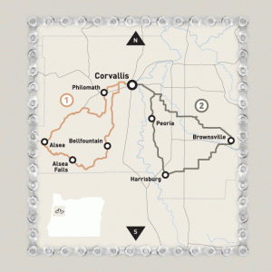
weekend ride.
Each year in July, Cycle Oregon hosts a family-friendly two day ride and this year they’re heading to Corvallis.
Riders will set up camp on the Oregon State University campus and enjoy between 11 and 68 miles of riding each day. Options are set up for everyone from families with kids looking for a leisurely afternoon to experienced riders looking for a challenge.
The announcement for the week-long ride started with a promise from co-founder Jonathan Nicholas. He said that this year’s ride would be “longer, higher, and harder” than years past.
He wasn’t kidding.
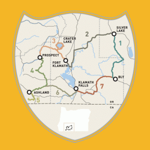
week ride.
The week ride starts in Bly, Oregon (about 45 miles northeast of Klamath Falls) and passes through the towns of Silver Lake, Fort Klamath, Prospect, Ashland, and Klamath Falls.
All seven days of riding add up to nearly 500 miles but you only need to look at the third day of the ride to see what Nicholas was talking about.
On day three riders will travel 88 miles from Prospect to Fort Klamath, between 2500 and 7000 feet above sea level, and around Crater Lake.
Now back to Nicholas’ announcement.
The news, which drew as much applause as the route announcements, goes back to the forward-looking sentiment Nicholas shared at Cycle Oregon’s volunteer appreciation dinner.
Nicholas started off by asking the audience at the Tiger Woods Center, “If we could imagine 25 years from now, what would the people sitting here…like to look back on and say ‘Look at what we did’?”
Cycle Oregon’s Directors have been pondering that same question and according to Nicholas they decided they’d like to see a paved, off-highway bicycle route connecting the Willamette Valley to the Oregon Coast.
To further that vision he announced that Cycle Oregon is funding a $100,000 grant to study how a trail like that could be built.
The reality of a paved coastal route is a long way off but Nicholas says Cycle Oregon’s organizers have already had discussions with state and local agencies about the idea and there are some seemingly feasible options he’s aware of. We’ll track this plan as it develops.
Registration (for both of the rides) is now open on the Cycle Oregon website. The weekend ride is limited to 2,000 riders and the week ride is limited to 2,200 riders. Both are expected to sell out quickly.



Thanks for reading.
BikePortland has served this community with independent community journalism since 2005. We rely on subscriptions from readers like you to survive. Your financial support is vital in keeping this valuable resource alive and well.
Please subscribe today to strengthen and expand our work.
Perhaps something heading west from Hagg Lake, connecting to the Trask River? That would be a great, direct route out to the coast – or one of several former rail alignments? There are some excellent options for a trail out to the coast.
This is an awesome route for the week ride, and I’m not surprised that Cycle Oregon chose once again to feature Crater Lake in an “anniversary” ride. (it featured in the 20 year ride in 2007) It’s a fabulous destination, and this year’s riders will certainly enjoy it.
I’m thinking the old Tillamook railroad alignment would be the most logical choice. It is currently abandoned, suffering from major slides in 2007. Here is the alignment:
http://www.cwconstruct.com/tillamook.html
This could be a simple rails-to-trails conversion, and would start in Wheeler or even as far south as Tillamook and tie in with the Banks-Vernonia trail at Buxton.
This will be the cheapest solution. It would also offer dozens of miles of trail that will be completely isolated, without a road that parallels the right of way.
Now they can take that $100,000 and put it towards buying the ROW…
I should add a note: it would not be a completely straightforward rails-to-trails conversion. There is a lot of work to be done to fix the damaged road bed in areas. Fortunately, bike paths are much more flexible in terms of grade and turns, so they should be able to engineer solutions that would be less susceptible to damage in the future.
I’d still like to see a train go out to the coast as well!! There are already paved paths…we just need to take them from cars. No sense in spending more money covering earth in cement.
All of the roads to the coast are one lane in each direction, with a few passing lanes. Major work would be needed to add even an 8ft bike path to the shoulder of many of these roads. Plus, would you really want to ride on the shoulder next to high speed traffic? A trail along this railroad ROW would be much more pleasant, with no auto exhaust or noise to deal with. The railroad has no interest in using this route. They spent their FEMA money on other improvements. The ongoing maintenance isn’t worth the cost, when most companies prefer to truck cargo on the highway instead.
Some more info:
http://www.portlandhikers.org/forum/viewtopic.php?t=4641
Scroll down about halfway on the page to see pictures. Hikers are already using this route, and you can see how nature is starting to take back the land. This gives you an idea of the scenery this route would provide, and some of the challenges they may face in converting in.
Chris, thanks for the links to the pix. It looks like it’s really deteriorated since i last walked it 3 yrs. ago or so. Ther Salmonberry Canyon is a very beautiful & pristine – and roadless – area. It would make a phenomenal trail to the coast, with reasonable grades and spectacular scenery – the trestles and tunnels, as well as winter washouts, could pose a challenge for construction/maintenance, but well worth it, as there’s no doubt in my mind this would be a premiere Oregon attraction.
Oh, and it looks like the abandoned rail line trail could be linked to the Banks-Vernonia trail without too much of a problem.
Maintenance could be the deal breaker. If they get a washout deep inside the canyon, the only access will be on the trail itself, so the type of equipment available would be limited.
Check out “Smith River Road” near Eugene.. It’s a very rarely traveled BLM road that is so scarcely used that t’s practically a giant bike path out to the Coast.
If anybody is looking for what to get me for my Birthday, this would be AWESOME!!!!
I’m going on the week ride; it filled up the 2200 rider limit in 44 minutes. I also correctly predicted the Ashland layover in October; thank you, thank you very much.
One of these years I would like to participate in this ride.
As would I. However, last year I DID participate in the weekend ride. It was worth entry fee. And as of this morning, there was still space available. But it too, will fill up fast.
Yeah, the week ride is on my “to-do list” for sure. Maybe in a few years.
There already exists a route to the coast that is just about car free – the Nestucca River Byway from Carlton to Beaver. Beautiful campgrounds are located about at the halfway mark.
An excellent three day trip can be had from Portland to the Coast. Max to Hillsboro then . . .
Day one camping at Dovre,
day two at Cape Lookout,
day three into Tillamook to catch the bus back into Portland (10 bucks!!)
The only sketchy part is a four mile stretch on 101 from Beaver to the turnoff leading to Cape Lookout.
There are excellent maps online for bicyclists.
This is a great route, but you should note that there is a 3mi section with packed gravel that will be an issue for cyclists with very skinny tires.
We did:
Day one: afternoon train to Hillsboro, ride to BLM campground along the Nestucca
Day two: Ride to Cape Lookout, enjoy the beach
Day 3: Ride back to Hillsboro via Highway 6, which I would not recommend due to high traffic.
I have done this route multiple times, and love it, especially Nestucca River Rd. The “gravel” section section is easily passable, and is more of a dirt road than anything. That section is actually the best part of the ride. There was this totally timeless feeling to that section, like I was pedaling along in 1920 or something.
One of the best rides I’ve been on was from McMinnville to Pacific City via Nestucca River Rd. We spent the night at a campground next to the beach after rehydrating at Pelican Brewery, and we rode back the next day. mmm…beer
Hi Charles, I am looking to bike to Dovre this weekend and wondered about how many miles/ how long it took you to get there. The forum I found the route on doesn’t have a map.
Chris – a rails to trails conversion out to the coast would be awesome, but I quibble with your characterization of the roads out to the coast.
“Plus, would you really want to ride on the shoulder next to high speed traffic? ”
I’ve ridden all the way to the coast along the Nehalem and the roads… 47, 202, 103, Foss Rd, Miami Foley are all beautiful and pretty darn quiet.
Yes, Yes, Lower Nehalem Rd and Foss Rd are gravel in parts so they can’t be included in a ‘paved’ discussion, but the bridge over the Salmonberry is now repaired so I hear. And yes, 26 is stupid, but that is really short and my next trip will be an exploration of a way to cut it out almost entirely.
FWIW I like this route much better than Nestucca river.
You’re right. There are other options for routing a road shoulder type path that would not have high speed traffic. The challenge is finding one that has room to do so without major engineering work.
It sold out already!
With all due respect for the Portland to Coast Route (I think it’s a great idea), we have another intercity bike trail that is already 2/3rds built and needs to be completed.
The Historic Columbia River Highway State Trail has just 10 miles left to go. Master plans, feasibility studies, and an alignment have already be set; It just need to be completed. Once its done, a Portlander will be able to bike all the way to The Dalles, past Multnomah Falls, Hood River, and the Mosier Twin Tunnels, without ever having to use I-84. More than 25 of the 73 miles on a paved trail, and the rest on the lower-speed Columbia River Highway.
I’m all for thinking big, and thinking long-term, but lets get that one built first!
I rode the Port of Tillamook route this fall. Rail to trail could be done.
http://www.therealherb.com/riding-the-burn-cycle/