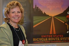
During a morning poster session (where bike and ped professionals offer up their latest research in science-fair style) here at Pro Walk/Pro Bike, I ran into Ginny Sullivan, the new routes coordinator for the Adventure Cycling Association (ACA).
Sullivan stood in front of an attractively designed new poster for an exciting project, the establishment of the United States Bicycle Route System. Once completed, the system will be a complete network of officially recognized, interstate bike routes.
The last time I checked in on this project was back in March when I chatted with ACA’s executive director Jim Sayer (Sayer is the political/lobbying arm behind the effort).

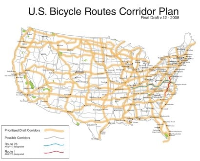
Sayer and Sullivan have been working through the lengthy process laid out by the key agency for this effort; the American Association of State Highway and Transportation Officials (AASHTO). AASHTO began this project in 2003 with the goal of developing a recommended, national corridor-level (50-mile swaths) plan for use by state department of transportations to designate potential future U.S. bike routes.
According to Sullivan, the ACA submitted a draft of their Corridor Plan (image above) to three key AASHTO committees. Two of those three committees have already approved the project. The final one, the Subcommittee on Design, is currently reviewing the proposal (to pass, it will need approval from 36 states).
Once the Corridor Plan passes that final committee, Sullivan says it will then go in front of the Subcommittee on Highways (what she refers to as “the Executive Board of AASHTO”). Approval of the plan is expected by this fall.
But Sullivan, Sayer, and project cartographer Casey Greene are not waiting for approval; they’re already working toward initial implementations of the system. Sullivan told me that the first route is already being planned. She’s working with Georgia and Florida on what will be called U.S. Bike Route #1. She has also looking at the West Coast and has talked with Oregon’s bicycle coordinator Sheila Lyons (“she’s very supportive”) and the head of California’s DOT.
For more information on the U.S. Bicycle Route System, visit AdventureCycling.org.


Thanks for reading.
BikePortland has served this community with independent community journalism since 2005. We rely on subscriptions from readers like you to survive. Your financial support is vital in keeping this valuable resource alive and well.
Please subscribe today to strengthen and expand our work.
Martha and the Vandellas (and X) sang \”Can\’t forget the Motor City.\” This bike route plan does forget Metro Detroit and fails to offer any connection.
I noticed the proposed routes roughly parallel the Interstate highway system. Of course in 20 years it won\’t make any difference any more as the Interstates and everything else will be bike routes, since that will be the only private vehicles still moving except horse-drawn coaches.
Does this mean that bicycles will have their right of way respected on these routes? If there\’s a collision between a car and a bike, will the bicyclist get any relief from law enforcement or state governments?
What does this \”network\” actually mean, other than an opportunity to post some signage about the possibility that bicycles may be found on these roads?
Pretty exciting to see the US follow the example of other regions (EuroVelo in Europe, Route Verte Quebec) to develop a nationwide bicycle route network, but I can\’t help feeling sorry for the folks in Boise and southern Idaho. What have they done to be left out? Even Fargo would get better served!
I\’m just as confused as beth h. Signage doesn\’t provide any comfort when log trucks are still flying by two feet away as I work to avoid rocks and glass. Will this actually mean some separate pathways?
I grew up in a lumber town and when a log truck comes up behind me- believe me I get off the road. If a log truck driver really hustles he can get 3 loads in one day rather than just 2 $$$. My riding buddies mom got dragged some distance by a log truck and never fully recovered
Should show more things, rest areas, fre wi fi areas, food places, bike shops, lodging, child safe routes IE bike pathes, showers, ….
Love the Poster… Where do I get them?
Okay. Let\’s put this in perspective, folks. As J says, Ms. Sullivan & Mr. Sayer work for the ACA – the Adventure Cycling Association. They create & sell maps and packaged (lightly escorted, mostly self-contained) group bike tour trips.
Jim @ #8, ACA route maps already show food, bike shops, medical, lodging, parks & camping, some terrain features (elev.) etc. within a corridor which the route traverses.
Beth H @ #3, No, no, and no, not much in the way of signage (although, if one knows where to look, there still remain some of the original 1976 Trans Am signs, posted for the United States\’ bicentennial when the organization was called Bikecentennial).
The big appeal, I believe, in ACA\’s maps and group rides, is to people who would never be inclined to make a long bike journey on their ownsome, or maybe just with a partner or two. Those who would be intimidated by the planning or daily waking up to the unknown are a lot more comfortable in a group and with a routine and parameters set thereby. That said, many solo riders and couples do buy the maps and mod the route to fit their own needs.
No, there is nothing special done to the already extant roadways to accommodate bicyclists when ACA maps a route — they are not a government entity and do not affect budgets. Heavily used routes, however, bear so many cyclists that small town businesses can see significant enough impact from route use to tune some services toward bikes.
The original US Bike Routes, 1 & 76, came out of the nineteen-seventies bike renaissance and kinda sputtered out on the Eastern seaboard (the red and the green traces on the PDF of the Corridor Plan linked by Jonathan above). They are actually signed (as 1 and 76) and incorporated into elements of ACA routes and the East Coast Greenway project. I have a beer here that says that an ACA-developed US Bicycle Route System would hang off of already mapped ACA transcon routes and assorted connectors in their catalog. These are definitely not MUPs or SUPs (separated Multi Use or Shared Use Paths) albeit they are usually on moderate or very low traffic roads. While appearing close to the Interstate System, ACA routes seldom venture onto it. These are by no means intended to be the fastest way from point A to point B, rather they are oriented toward fully-loaded touring at maybe 60 mile-per-day, group campground experiences with options for \”credit card campers\” (lightly loaded semi go-fast bikes, motels and diners). Interlacing them with rail-to-trail conversions (mostly MUPs) across the land might optimize connecting ACA\’s established routes.
The second N-S corridor from the left coast looks suspiciously like Bil Paul\’s Pacific Crest Bicycle Trail, which I understand ACA is negotiating with him to acquire/jointly develop. Been on parts of the original route and that\’s gorgeous.
ACA is about biking wa-a-a-a-y outta yer neighborhood and discovering America up close and personal. I have been a member off and on for some years (current), but we ride to different drummers (even if the national HQ in Missoula, MT, does have a dedicated bike tourists\’ lounge where they keep a freezer stocked with free ice cream for visiting riders). If America is gonna get its bike act together, we need long-distance, forward-looking outfits like ACA to bring realistic voices to the table with national traffic standards entities like AASHTO and the Feds.
Even if I rode that entire Corridor Plan, I will always love coming home to Portland.
Jene-Paul
Greetings from Seattle,
We\’ll try and digest and respond to the comments but I encourage you to look at the links to the actual project. This is not just about ACA routes or rural riding. It\’s about creating an official urban-suburban-rural route network in the U.S.
Check out the link to Jonathan\’s last post and my response to some of the comments there (#14) — copied below too — http://bikeportland.org/2008/03/06/imagine-a-national-bike-route-system/
Thanks for your interest,
Jim Sayer
*******
March 2008
Thanks for the great post. Just got back from Washington and would like to respond to all the comments briefly — all very good responses to the first phases of this big national effort. Just please note that these are \”corridors\” — 50 mile wide bands that give rough parameters to help establish routes — not necessarily Adventure Cycling\’s existing routes. There are so set routes yet, so don\’t presume anything. Also, please know that the standards are not set for what there routes could be — backcountry roads, hard pack trails, highways with decent shoulder and no/constrained rumble strip. If you go to the weblink, you can get more detail. The beauty and challenge of the project is that many interests are engaged, people can help develop the interstate routes (after the corridor plan is adopted), and there may even be interest at the national level in helping with resources to sign and maintain a national network. We\’ve had some positive early meetings with several members of congress, including Congressman Jim Oberstar, who was very enthused about the project and wrote (along with Cong. Peter DeFazio) a glowing letter of support.
BTW, I agree with the writer who said this is no substitute for local routes and metro networks, which are critical for transport (and even recreation). The US bike route system will be complementary and can act as the linking framework for these metro networks and other key destination points, like our national parks. This is similar to the urban/suburban/rural model that is being used in Great Britain. Their National Cycle Network has created an investment focus that has drawn over $750 million in national lottery proceeds and growing popular support — plus surveys are showing dramatic growth in trips on the network, leaping from about 225 million trips in 2005 to 338 million in 2006.
Obviously, a lot to do and talk about — just glad Jonathan got it rolling.
If you have questions/thoughts, review the background, share ideas here, or contact me or Ginny Sullivan, our very tenacious, good-spirited New Routes Coordinator at 800-755-2453 or our first initial and last name at adventurecycling.org.
I am a life member of Adventure Cycling and I support a route system, but this is not the route system I can support. I have sent Jim and Ginny a more detailed critique.
It\’s sad, but this route map appears to have been created by people from … yikes, Montana. The routes do not actually go where people live, or where they want to go. It appears to me that Adventure Cycling thinks that, because there are three great transcontinental bike routes they have planned, that having five or six more would be even better.
Crossing the United States on a bike is a stunt. It\’s a great stunt, but it doesn\’t really demonstrate what a bike can do as part of an everyday transportation network.
Look at this map closely! There are some really ridiculous routes planned here. Who is ever going to ride a bike from Lubbock, Texas, to Williston, North Dakota.
Meanwhile, important cities like Atlanta and Denver are almost completely ignored. The route map fails to connect major cities in natural ways. Doesn\’t ACA understand that most Americans live in cities, and that most travel is to and through major cities?
I already wrote to Jim and Ginny in private a few months ago, and asked them to take this route map idea back to the drawing board. Please join me in asking them to take another look.
Howard
I agree with Howard (#12) and Todd (#1) completely. Detroit is the 11th largest city in the US. Detroit, Denver, Atlanta are major metropolitan areas. And Idaho gets short shrift here – the routes skip 90% of the population in that state, and the mostly level route through the valley.
Does the ACA expect these metropolitan regions to push for their own connections to this network? How is this network in any way anything other than a promotional tool for ACA\’s goods and services?
Don\’t get me wrong, the ACA has done some good work, but this \”final draft\” seems to omit a number of important areas. It\’d be great if they at least posted their rationale behind the final draft, or made available prior versions for examination. Did they make their meeting discussion/minutes public?
I have too many irons in the fire at the moment, or I\’d dig into this myself. I encourage those with the same questions espoused here to contact the ACA and ask them. I\’d like to know what the ratio of symbol to substance is here, and if anyone is inclined to pick up the torch and run with it, please do.
Really cool poster, though!
Greetings from Adventure Cycling,
First, let me thank Jonathan for his continued coverage of the U.S. Bicycle Route System. One of the key outcomes of having the corridor plan out there is that it’s been the impetus to get people talking about cycling at the regional and national levels.
Before we had this plan, the United States had two designated, semi-finished US Bike Routes, but no new routes in almost 30 years. At least now, states, cyclists, trail groups and advocates are talking about the possibilities. That’s really what the corridor plan offers, a multitude of potential corridors but not a limit to them either. Below, I have copied the 10 facts that accompanied the poster seen in Jonathan’s photo. These might be helpful to understanding the concept of the corridor plan and the potential for developing US Bicycle Routes.
10 Fast Facts about the USBRS
The U.S. Bicycle Route System (USBRS) will one day be a network of officially numbered interstate bicycle routes that connect America’s cities, suburbs and rural areas.
The Draft Corridor Plan is a corridor-level plan for the development of future U.S. Bicycle Routes.
Corridors are not routes but 50-mile wide swaths that link key destinations, urban centers and take into account the natural landscape.
Corridors can be added, changed or shifted by states as needed.
U.S. Bicycle Routes are defined as routes that cross the border of two or more states.
U.S. Bicycle Routes may be on roads or trails suitable for bicycle travel.
U.S. Bicycle Routes are chosen by state departments of transportation (DOTs), possibly in coordination with other agencies or organizations.
U.S. Bicycle Routes are catalogued and designated by the American Association of State Highway Transportation Officials (AASHTO), the lead non-profit organization supporting state DOTs.
U.S. Bicycle Routes will be designated with numbers and may be signed and/or mapped.
There is currently no appropriated transportation funding specifically for U.S. Bicycle Routes.
I’d also like to quickly address some of the questions and comments on the blog. One way is to copy you on the email I sent in May to Mr. Metzenberg (#12):
Sent: Friday, May 23, 2008 3:27 PM
Dear Mr. Metzenberg,
I wanted to thank you for the feedback you provided on the US Bicycle Route System Draft Corridor Plan. You have obviously studied it in great detail and I truly appreciate that you’ve looked at not only the corridors, but the system we went through to draft it.
I would be remiss in not agreeing that ACA has played a large role in the project, however, this is not an ACA initiative, it is an AASHTO initiative that ACA supports with part-time staffing. The Task Force is made up of traffic engineers, planners, designers and staff from federal highway administration, including the National Scenic and Historic Trails Coordinator. They’ve overseen and advised the project since the vision was established in 2003. The plan is now being further reviewed by the state agencies themselves and they will provide us additional feedback which we will incorporate as necessary before it is approved by the AASHTO Board of Directors in October.
We’ve had countless people associated with bicycling and transportation view the corridor plan over the past 3 years. It has been an open process. Most cycling advocates feel that the corridor plan allows for connectivity to many significant urban hubs while keeping the corridors viable for recreational cycling as well. We are shooting for a bit of both, a balance, if you will. This is a plan to use for designation and connectivity across state lines; where the route will actually go is up to the state agency that will be applying for AASHTO designation as a US Bicycle Route. The state agency must work with multiple municipalities (counties and townships) when choosing the route that follows the corridor, including the neighboring states. The Task Force has continually assured the states that the Corridor Plan is no way a limit on where they can put the routes, but will serve as a guide for them in design, as well as, aiding the AASHTO committee that assigns the designation (ie. U.S. Bicycle Route 76). You make a valid point about the routes following historic and cultural corridors as well as key vacation destination points. The Task Force will encourage states to focus on these as they implement the corridor plan into a true route network.
I will be sharing your commentary with the Task Force Chair as we begin to strategize on how to help states implement the corridor plan into designated US Bicycle Routes.
Thanks again and best wishes for a great summer of cycling.
Best regards,
Ginny Sullivan
*******************************
I hope you will see that this corridor plan, while not always linking ALL cities and destination points, did get vetted and isn’t stagnant – we call it a living plan, changing as we get more feedback and interest (we are on the 12th version). The Corridor Plan is a starting point for developing multi-state routes and, as I told Todd (comment #1) in an email yesterday, Detroit can be a part of the USBRS if Michigan determines it is “nationally or regionally significant” and it links to other important corridors in the aligning states (like Ohio). The Corridor Plan, in original concept, was extremely dense. It was necessary to prioritize corridors in order to come up with the designation system (numbered routes) for AASHTO to review.
One other point: the USBRS does not secure more “rights for cyclists.” The Task Force is concerned that current AASHTO policy might preclude some states from being able to choose the best roads for bike travel but we’re working to make sure the new AASHTO Guide for Development of Bicycle Facilities corrects that. We have a lot of work to do and your support in this effort is greatly appreciated by those of us who believe in this project – the Task Force, ACA members and bicyclists nationally and across the globe.
Thanks,
Ginny Sullivan
New Routes Coordinator
Routes and Mapping
Adventure Cycling Association
Phone: 406.721.1776 x229
http://www.adventurecycling.org