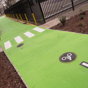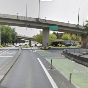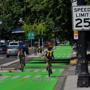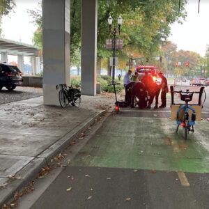
Cyclists who are tired of dodging pedestrians, dogs, and tourists on the popular Waterfront Park riverfront path, now have a more direct route all to themselves. Striping crews were at work today on the new bike lanes coming to Naito Parkway. They’ve added the bike lane characters and final striping is expected soon.
The new, 5′ wide bike lanes go from SW Jefferson to NW Couch, just south of the Steel Bridge. They come as part of the Naito Parkway Reconstruction Project, a federally funded project that has rebuilt the worn-out street from the ground up.
To make room for the lanes, a center median was narrowed. On the west side of the road, curbs were pushed back to make room for new on-street parking.
Check out a few more photos.


Thanks for reading.
BikePortland has served this community with independent community journalism since 2005. We rely on subscriptions from readers like you to survive. Your financial support is vital in keeping this valuable resource alive and well.
Please subscribe today to strengthen and expand our work.
Yay! I’ve been hearing about this for years. If recent trends hold, there will be significantly more bicyclists this summer than ever before, especially on the Esplanade and Waterfront Park, and I am happy to have a “fast lane” when I don’t feel like dodging pedestrians in the clogged park.
In a word, “Mazeltov.”
Yeah, geez, today was a mess. I’m glad everyone is out having a good time, but I fell off my bike avoiding some amateur cyclist who went into some bizarre weave across the waterfront path without any warning or looking behind him.
5′ is wider than a normal bike lane, right?
No, 5′ is standard in Portland, but we are probably headed for a more generous standard in the future.
To give some comparisons:
26th Ave just north of Powell is only 4′
Most of the lanes you ride in are 5′ or 5.5′
The new Vancouver Ave bike lane is 6′ (or is it 6.5′? Roger?)
However, because Naito Parkway has few driveways, and because there is no on-street parking, there are few vehicular turning conflicts across the bike lane. So, a 5′ bike lane is likely to feel fine.
Yeah! Taking a lane was always an exciting experience.
Now if only we could get those lanes extended south to the Barbur/Naito split (south of the Ross I. bridge exchange)
Yay! I was just thinking to myself that I needed to find a way to avoid the Esplanade now that the weather is nice. I don’t mind slowing down for the peds and slow riders, but given the option of a way to go faster and not have to worry about being clotheslined by dogs on extendo leashes, I’ll take it!
So is the west side bike lane wider (6′)? Since there is new on-street parking?
“To make room for the lanes, a center median was narrowed. On the west side of the road, curbs were pushed back to make room for new on-street parking.”
Don’t count on a 6’bike lane. Oregon planners think there’s no such thing as a bad bike lane. They are all good no matter how narrow or how close to parked cars. Consider Tillamook St., the pride of Portland. So now it’s a choice between dog leashes and car doors.
Nice pictures Jonathan, but let’s see some pictures of the southbound bike lane next to parked cars with their doors open.
Kat,
you won’t find any parked cars on Naito.
Those of you who are over that way, also check out the cool cut-through at the ramp coming off the Morrison bridge. I’m eagerly awaiting the actual striping to be complete.
Matt said: “you won’t find any parked cars on Naito.”
Apparently that is about to change, if I read the article to which we are responding correctly:
“To make room for the lanes, a center median was narrowed. On the west side of the road, curbs were pushed back to make room for new on-street parking”
yep. Cecil’s right. according to a conversation I had with geller yesterday, the west side of the street will now have on-street parking. I think this might actually help slow traffic.
Wow – that’s interesting. I look forward to seeing what that looks like. When I rode on Naito the other day, from a few blocks north of Morrison to Hawthorne, the “placeholder” marks for the bike lane striping were against the curb. I’m wondering if the on-street parking is going to be outside of the bike lane? (i.e. the bike lane between the parking and the curb)
Hmmm….. I think I need to ride over there again today after work.
yay! i found myself looking forward to nasty weather, as it tends the keep the ipod-zombies and double wide strollers out of the waterfront area.
paul: you’re a brave man.
I rode the new Naito Parkway bike lane on Friday before it was striped. It was glorious. Smooth and straight.
There are storm drains that protude into the lane every 100 feet or so. So the left half of the lane is preferable. It’s still better than dodging pedestrians at the waterfront.
It will be interesting to see whether the storm drains are standard or double-width. My recollection is that the double-width storm drain grates were supposed to be phased out a number of years ago, but they just keep showing up on new PDOT projects anyway.
Well, maybe with the new bike lanes on Naito we can get PDOT to open the old Hawthorne on-ramp back up for cyclists, so we don’t need to circle the block to get on the bridge.
I tested the new bike lanes on my way in to work this morning, southbound from the Steel Bridge to Main Street – it will be nice when they paint in the white barrier line – as it is, the cars were in the bike lane a good bit of the time. I am not as concerned about the on-street parking on the west side – they way the curbs have been cut to create the parking havens makes the chances of being doored slimmer. The bit by the Morrison Bridge ramps is a bit tricky, though . . .but not as tricky as dodging dogs on the Esplanade. All in all, I was very pleased.
I rode Naito yesterday evening on my way home. The bike lanes extend to one block south of the Hawthorne bridge. The closed ramp to EB Hawthorne had signs up and at least one piece of parked equipment, I don’t know if that’s indicative of anything. Given the volume of traffic on the bridge, and that the bike lanes effectively end there, I’m hoping that means we might see the ramp opened to bikes.
Parking on the west side is accomplished through curb extensions – if cars park all the way against the curb, there is enough space in the SB bike lane to avoid most doors. If they park away from the curb, it’ll be dicey. The cut-through at the EB Morrison ramp to SB Naito has no signal to stop cars for bikes, so that’s a potential hazard area – hopefully PDOT is going to sign that ramp, or add a signal.
I rode south on Naito Parkway yesterday. I’m glad I stayed out of the door zone bike lane, because in addition to the door hazard, there is a concrete island in the lane.
Kat (Post #20), where did you encounter the concrete island in the bike lane? I ride Naito south almost every day from the Steel Bridge to Jefferson and have not encountered thise. The only thing I can think of that might match your description is the lane barrier where the Morrison Bridge off-ramp feeds onto Naito, but that has a cut-through in it specifically for cyclists. Now if they would just put up a nice little “Yield to Bikes” sign for the cars coming down from the bridge there . . . .
Is it me or the northbound lane abruptly end on Naito with no ramp access to the Willamette greenway trail. I was on it a few days ago just to “try” this new bike lane out. Since I’m a slow rider, I don’t mind looking out for pedestrians and slowing down even more in congested areas. I prefer off-street paths every chance I get to avoid ingesting car exhaust just feet from the tailpipes. How about some downtown streets where bikes can get away from the car fumes?
Yeah, the north end is kind of funky. There is a ramp at the end, but it leads to the sidewalk that goes up and over the bridge instead of to the Esplanade and the lower walkway – there is a path to the Esplanade, but it involves a set of steps. To get to the Esplanade with riding on the grass or down the steps, you have two options – exit Naito at the light by the entrance to the internment camp memorial (I am spacing on the street name) or continue on Naito past the car entrance ramp to the Steel Bridge (which requires crossing that entrance ramp and taking the lane) – there is a ramp up onto the sidewalk just past there by which you can gain access to the Esplanade.
I prefer to ride through the grass to get to the lower Steel Bridge. Visibility through the internment camp memorial isn’t very good.
Well, today there was a new and interesting hazard in the northbound Naito bike lane – golf carts!!
The Rose Festival “Fun Zone” people have golf carts that they use to get from one end of the zone t’other and they use the NP bike lane as a short cut. Unfortunately, they are headed SOUTH. As in head on . . .
This concrete island in the bike lane.
http://www.geocities.com/vcadvocate/Naito1.JPG
Now that I went back to take pictures, I see what silly maneuver the city had in mind. However, this picture
http://www.geocities.com/vcadvocate/Naito2.JPG
is what you see from farther back. If I had been in the bike lane, when I saw that, I would have merged left a lane long before I saw the jog to the right. Just what is a cyclist supposed to do there? It\’s like a lane change, except that unlike an ordinary lane change in which the two lanes are parallel, one is changing to a lane that is perpendicular to the original lane. In an ordinary lane change, one can continue in the current lane until there is a gap in traffic in the new lane. In this case, if there is no gap in the right lane, the cyclist must stop and wait for an opportunity to merge. Where\’s the sense in that?
I agree that it is not intuitive, and that a sign telling cars exiting the bridge to yield to bikes would be a great addition, but I don\’t think it is all that silly, given that the city was trying to engineer a way to accomodate bikes and all those wierdly merging cars . . . .
Why should the motorists yield? The cyclists are the ones changing lanes. At that point the motorists aren\’t merging at all, weirdly or otherwise. If they want to go south on Naito rather than turning right at the next intersection, then somewhere in that block they make a normal merge leftward. Why does the bike lane move sharply to the right, only to move back to the left again? It should stay to the left for the whole block. Then the southbound motorists would still make a normal merge, but they would move two lanes left. Then as part of their normal lane change, they would be required to yield to cyclists.
The city was not trying to accommodate bikes and cars. It was, in its paternalistic way, treating cyclists like children who don\’t know how to ride in traffic.