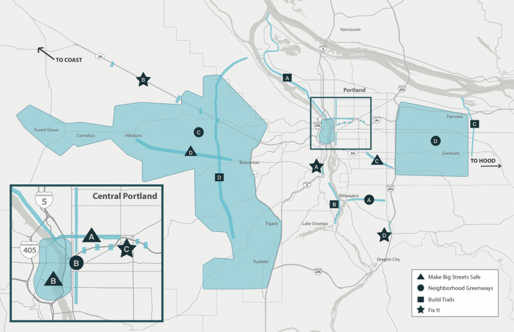
Oregon’s leading bike advocacy group has named sixteen projects in four categories as their top bike infrastructure priorities for the region.
Released Tuesday, it’s the first update of the Bicycle Transportation Alliance‘s “Blueprint for World-Class Bicycling” since 2005, when the organization named 40 such projects. This time around, the group sought to focus on a smaller number in an effort to increase the pressure on behalf of the selected projects.
The BTA sorted the projects on its list into four key concepts:
The BTA also called out the potential for a “Hood to Coast Trail Network” that could one day become a major tourist and recreation destination by linking Portland and Mount Hood to the Pacific Ocean.
You can check out the BTA’s description of all its priority projects here, and also sign up to receive BTA alerts about the projects. You can also download the full Blueprint as a PDF.
The BTA’s selection of these projects was based on input from 900 people who responded to an online survey, plus another 120 who attended 16 community meetings across the metro area over the course of about three months.
In all, the work required more than 1,000 hours of staff time. It was completed with support from the Bullitt Foundation, Bikes Belong, Nike and multiple in-kind donors.
In an interview last week, BTA Director Rob Sadowsky said the organization was forced to leave important projects out of the Blueprint, but plans to share research and advocacy on behalf of its Blueprint projects with other organizations that may have different priorities.
“We see the 16 projects as being almost metaphorical,” Sadowsky said. “You can plug and play: you can take out North Broadway, for example, and plug in North Williams. … You can take out Foster and put in Sandy.”
Sadowsky said they’d tried to select projects that they felt wouldn’t happen without a clear push from the BTA.
When projects are completed, Sadowsky said, the BTA plans to swap in other priorities to replace them.
“We don’t want to make this static,” Sadowsky said. “We’ll make sure that there’s always 16.”


Thanks for reading.
BikePortland has served this community with independent community journalism since 2005. We rely on subscriptions from readers like you to survive. Your financial support is vital in keeping this valuable resource alive and well.
Please subscribe today to strengthen and expand our work.
Good news for the Foster Road project! The three-auto-lane option with buffered bike lane (parking protected in most of the way) was ahead in comments on the bulletin board at the ‘Super Open House’ today! Three auto lanes with non-buffered bike lane was a tick behind and both the four-auto-lane options were well behind. Yay, keep it up, Foster citizens!
It was a little more evened out by the end of the evening (I think the Lents folks finally showed up). But the 3 lane options were still ahead. Sadly I don’t think this straw poll will have a ton of weight in the final decision. Though I’m confident that some kind of bike infrastructure will be built on Foster (even if we don’t get lane reduction), which is still an upgrade from the current environment
Just imagine how many bike projects could be funded with $450million dollars.
Another way to look at this would be to identify 16 projects* that shouldn’t get built , that would free up money for those that we would prefer be built.
*or just one really big one…
A big “YES” to the NE 7th/SE 9th proposal with a new bike/ped bridge over 84 in the middle. Talk about a project whose time has come after so many years of talk and study.
I would like to see the city look at two options: a bike/pedestrian bridge, and a 2-lane vehicle bridge with bike and pedestrian facilities built to the latest standards. This would do a lot to show the cost of building for bikes/pedestrians, and the cost of building for cars.
Why so much emphasis on Washington County? That place is fundamentally unbikeable (forget infrastructure, just look at land uses, block structure, roads, distances), its like trying to turn the Arctic into the Sahara. If you are into biking and want to get around by bike, move somewhere in the region designed for it or that at least actually has potential with improvements (which would still be a huge feat). Even East Portland has way more potential than WaCo.
they have more room for dedicated bike facilities…
“Why so much emphasis on Washington County? That place is fundamentally unbikeable (forget infrastructure, just look at land uses, block structure, roads, distances), its like trying to turn the Arctic into the Sahara. …” i ride my bike
Always has seemed plenty bikeable to me, but each to his own. The advance of ‘progress’…suburban and high-tech industrial,population growth and the resultant excessive use of motor vehicles has made biking progressively more dependent upon bike lanes and whatnot, but cities, towns and the countryside itself has always been very inviting for biking.
Particularly, traveling between Cedar Mills, Cedar Hills, Beaverton, Aloha, Progress, and Tigard, Hillsdale, Multnomah, Garden Home, isn’t so arduous. Travel between those points does involve longer trips than from Portland’s close-in neighborhoods to Downtown, but that’s not saying much.
I haven’t even looked at the project list yet, so I’m enthusiastic to see just what the BTA may have looked at for bike infrastructure improvements to be made in Washington County. I know some of us out here definitely have ideas about improvements that would be welcome.
Just browsed BTA’s 16 project list, including those for Washington County. It advises connecting existing bike lane segments along TV Hwy for a continuous bike lane. There are those that don’t seem to mind riding alongside highways like this, but I think many people would find the experience to be awful…a place they would not consider riding. Unfortunately, the list does not suggest a project designating, improving, and making continuous from 170th to Hillsboro, Johnson and Alexander streets, roughly just a block to the north of TV Highway, for a bike route.
Johnson and Alexander are generally very good streets for biking: currently low motor vehicle use. The streets though, are old, rather narrow width country roads. And, the straight shot Johnson and Alexander provides along TV Highway, ends at Cornelius Pass Rd and obliges a rather challenging, circuitous route the rest of the way to Hillsboro. It would take commitment and investment to secure easements to make Amsterdam type cycle tracks along them, but in the long term, probably very well worth it.
On the south side of TV Highway, an improved, companion route to a north side Johnson-Alexander cycle track, would be a great project too.
wsbob- What you lay out was pretty much the recommendation of the TV Hwy corridor plan, completed last fall:
http://www.tvhighway.org/?p=library-and-documents
I.e. *both* complete bike lanes on the highway, *and* complete low stress parallel routes, both on Johnson/Alexander/Shaw, and on a future trail south of the RR ROW. Also lots of emphasis on improving crossings of the Hwy, which, from personal experience, are often more stressful/dangerous that riding on TV Hwy itself!
I hope the BTA is consulting the plan in their advocacy – a lot of care and attention went into it…
It seems like a strange stance to take. Rather than make an area better for cyclists, we should abandon it completely? I may be biased, as I live in Washington County, but Washington County, being suburbs, already has an advantage: wide bike lanes on major roads. Not to mention greenways and a MUP that leads from Cedar Hills up to Sylvan (super convenient and well-used).
You may be surprised at the amount of cyclists (commuters and otherwise) that cycle around Washington County. Don’t forget that Nike, Intel, Yakima, etc, are all out that way. And a lot of these people don’t even live in Washington County. I pass a lot of them going up over the West Hills (going the other way) when I ride out to my work near PDX.
On the contrary – there is huge potential. Major concentrations of jobs, mostly flat terrain, bike lanes on many arterials, and some great neighborhood greenway potential on parallel streets like 5th/6th in Beaverton, Alexander St in Aloha, Grant St in Hillsboro.
I really enjoy my almost daily bike commuting in Beaverton neighborhoods. Along the same routes that wsbob and zigpdx have mentioned.
I work in Washington county, and strongly disagree that it is unbikeable. Beaverton in particular has an excellent system of bike lanes (as suburbs go, that is) that often get you around nearly as fast as in a car, at least at busier times. The system already works half-decently for Enthused and Confidents like me, and could easily be made better with some traffic calming and fixing gaps to create neighborhood greenways.
I wonder about the value of making TV Highway friendlier (improving parallel routes like Millikan and 5th/6th might be a better solution), but then again TV does kill cyclists and pedestrians on a regular basis (someone seems to die every year or two) so we’re talking about actual lives saved here.
IMO the worst aspect of Washington County isn’t getting around in the county itself, it’s the transition between Washington and Multnomah (i.e., the West Hills), which is still sorely lacking in connectivity. Overwhelmingly the greatest need I see in this respect is to make a better connection from the westside to N/NW Portland by completing the westside greenway (aka Forest Park Connection). That would be HUGE.
Although I haven’t really biked much in Beaverton, it seems like the city would benefit greatly from designated neighborhood greenway routes. Many of those residential streets dont get much traffic and can be great connectors. Does Beaverton do any outreach or marketing for its bikability?
It does have a bronze designation.
It would be nice if they signed some of the better routes though. They exist (ie parallel to most of TV Highway) but to find it requires some time with a map.
As for ‘designated neighborhood Greenway routes, I’ll defer to people more familiar with secondary streets in Beaverton that would meet that criteria…what I think of as being lower traffic, slow, easy going streets to ride…but (and this may be where the complaint ‘i ride my bike makes, rings true), I’m thinking Beaverton doesn’t currently have many of that type of street that say for example, connect neighborhoods with downtown. I can think of some that sort of do that…Millikan Way, Parkway, Greenway. Millikan is quite good.
The Beav does some outreach…Bike Advisory Committee that meets regularly, has an annual summer city neighborhood bike ride, nice event…but I’d say the reach is modest. I haven’t been to one of the BAC meetings for a long time now. The city could benefit from people in the area biking, or that would like to bike…being more vocal about their interest in expansion of bike infrastructure in the city.
Nice people in city hall, but I think it probably takes something fairly solid for them to feel justified in putting effort towards ideas beyond basic objectives…bike-wise, maybe increasing signs of a daily conflux of people riding, that would bring to mind Portland’s Williams Ave, or across the Hawthorne Bridge.
“…a better connection from the westside to N/NW Portland…” GlowBoy
Long time in need of attention, and I hope it at least has been picked up by the BTA’s radar: the section of Skyline Blvd immediately north of Hwy 26 at Sylvan, that rises for three-quarters of a mile or so to the intersection with Fairview Blvd( Fairview Blvd from the west, drops down almost to West Burnside at the south border of NW Portland.
The climb, not having at least a modest 3′-4′ bike lane for this section of Skyline, makes it very arduous going for all road users. This is a bad situation that’s existed for many years.Traveling between the westside and Portland many people on bikes regularly use this section of Skyline.
Being a steep grade, the descent isn’t too badly impaired by not having a bike lane, but the ascent definitely is impaired. Being a quite short section of road, suggests the expense of improving this section of Skyline for safety and functionality, could be comparatively low.
“the section of Skyline Blvd immediately north of Hwy 26 at Sylvan, that rises for three-quarters of a mile or so to the intersection with Fairview Blvd” – wsbob
Agreed. Lately I’ve been taking the Canyon Ct-Highland Pkwy-Upland-Fairhaven route to Fairview, because of the high conflict risk on Skyline. But that route is less direct, probably involves slightly more climbing and requires studying a map beforehand to figure it out.
Adding a bike lane, even just for that short section of one side of Skyline, would substantially improve the lesser-of-evils menu of options for getting across the West Hills.
Looking at the map, the route you describe is very circuitous. Long ago, I believe I’ve ridden those streets a couple times as and alternate route, but I don’t remember liking them; narrow, twisty, lots of cars being driven in and out of the neighborhood. Only good for the most leisurely riding. Even if they were marked well for a bike route, I’m not sure people would take to riding them as an alternative to the section of Skyline in question.
It’s exasperating that the section of Skyline north of Hwy 26 has gone so long without installation of a slow vehicle/climbing lane. If there’s been engineering evaluations and a cost estimate to make improvements to it, sharing details about them with bikeportland readers could be helpful towards making some progress towards this work being done.
Ok, so maybe this was a troll comment, but I have to point out the utter blindness of this comment when it come to equity.
Along with downtown Hillsboro, Aloha is where much of Washington County’s low-income housing is concentrated. There is *heavy* bike usage amongst the low-income, immigrant and minority communities that populate the older apartment buildings located back off of TV Hwy. Every day on the 57, I see beat-up mountain bikes chained to anything and everything near the bus stops.
Remember, we are moving to the french model of cities; when you heap scorn on the ‘burbs, you are also heaping scorn on those who can’t afford rent in central city districts with their attractive urbanist amenities.
I am hugely *relieved* that the BTA is emphasizing project areas like TV Hwy, along with the projects so dear to the well-informed, well-connected cyclists that have shaped bike policy over the years.
“fundamentally unbikeable”
I can’t tell if this is just FUD, or more urban-elitist suburb bashing–but I and many others bike in/around/through Washington county every day. Biking around a place would seem to fundamentally contradict a classification of “unbikeable”.
As other commenters have mentioned, there are a lot of places where a short key connection, if built, would open up a good deal of bike travel possibilities. US26 crossings are indeed a big one; the only pretty tame crossings are at Murray and the Sunset TC. Everywhere else it’s like one freeway crossing another, with very little in space dedicated to bikes. With small improvements, connectivity across the freeway could be opened up to many more who aren’t necessarily strong & fearless.
As far as “emphasis” goes, WaCo is targeted for four out of 16 projects, in three counties. What do you mean by “emphasis”?
The report needs improvement on North Barbur. There, because of speeds the solution should be physically separated bikeways. If cost is an issue, make a single bikeway combining North and Southbound in one path.
That route serves huge numbers of reasonable cost apartments supporting PSU and downtown employment. With safe bike and pedestrian access, more could be built.
So does this have teeth? By whittling down the number of projects, does that mean these projects are in fact going to be implemented faster?
I’m all for increasing the pressure on key projects to get them done, and they very well should be, but are we going to come back here in 2021 and read a report that the BTA is putting pressure on like 6 of these 16 projects?
I’d also like to say thanks, BTA. You do some really good work.
I’m just a little sour today because I drove the car.
I also disagree that Washington County is unbikeable. I bicycle all over it 🙂 Seriously, my commute is 10 mi each way; approx Hwy 217 to Intel Ronler Acres. There’s even grocery stores and places to eat if I want to stop along the way and pick something up. But I would like safer Hwy 26 crossings. That one over Cornelius Pass – 5 ways to die, there.
This comment comes a bit late, but I do need to add that there is another crossing of the Sunset highway that many people don’t know about. It’s easily the lowest-stress of any of them, and only 1/2 mile from awful Cornelius Pass Road.
The Rock Creek Trail undercrossing, which I’ve only recently discovered. It is a moderately-used, wide, paved path next to a lovely bubbling creek. It connects Evergreen Parkway on the south side, which has excellent bike lanes and a friendly new signalized trail crossing, with quiet residential streets on the north. I just rode it for the second time on Friday, and found it to be easily the most pleasant way to get from one side of US 26 to the other. It’s between Cornelius Pass Road and 185th, and I strongly recommend it as an alternative to either of those crossings.
Good start, I would have liked to have seen “Kenton To The River” get included. New I-5 bridge or not.
Ted Buehler
Congrats to the BTA! This looks like a very solid set of priorities.
However, not to nit-pick (the comment section of Bikeportland is where we do it!) but I was bummed that in mentioning the Sullivan Gulch trail priorities they did not include the proposed undercrossing at I-205. This key section of the Sullivan’s Gulch Trail would connect to Gateway Green and East Portland neighborhoods. It is significant not just for the Sullivan Gulch Trail and the Gateway Green project but also in restoring a human-scale connection between neighborhoods historically severed by I-84 and I-205 and- in the case of Parkrose Heights and Hazelwood- lacking good access to parks and trails.
Jim
I love the work that BTA does but BTA is missing a big piece of the local cycling constituency by once again failing to prioritize the expansion of singletrack trail opportunities for mountain biking. BTA needs to get front and center on the topic of trail access in Forest Park. Without it, the region will never be “World Class.”
I disagree. The “T” in BTA stands for transportation. Mountain biking has very little overlap with transportation and needs a separate advocacy group. In general improving single track facilities requires building relationships with totally different agencies (parks and forest vs streets and highways).
Trying to do both would just dilute the BTA’s core mission.
BTA’s Mission Statement reads: “The Bicycle Transportation Alliance creates healthy, sustainable communities by making bicycling safe, convenient and accessible.” While I agree that many off-road cycling issues demand a somewhat specialized focus and expertise (thankfully, we have the Northwest Trails Alliance for much of the dirty work), I disagree that BTA can or should just look the other way on mountain bike issues. Transportation and recreation are too closely tied together to regard them separately. Case in point: right now, every mountain biker in Portland has to get in a car in order to go find a singletrack trail. That’s ridiculous considering there is an extensive, perfectly suitable singletrack trails network abutting the city center.
Promoting off-road cycling opportunities is promoting cycling, and if that’s not part of what BTA wants to do, then maybe a name change is in order. How about Paved Cycling Alliance (PCA)?
I think the “Transportation” part of their name makes it pretty clear. No one is asking the NWTA to advocate for cycletracks to improve access to trails near the city.
On the contrary, it’s my understanding that NWTA is very much aware and supportive of the type of non-dirt connections that would be critical to things like the Intertwine project and other regional transportation/recreation networks.
But maybe I can refocus this conversation a bit. Why WOULDN’T we want BTA speaking up for mountain bike trails, especially those that are so co-mingled with the city’s cycling culture? What’s the objection? Not enough resources? That may be true – and hard to argue with – but BTA could still take policy positions without committing significant resources. I don’t imagine that BTA and NWTA are or should be anything but sympathetic allies on these issues, so why not a higher profile from BTA on trail sharing?
“right now, every mountain biker in Portland has to get in a car in order to go find a singletrack trail.”
Some of us don’t have cars to get into. We still manage to find single track. It just takes a while to bike there. I’m not saying Forest Park couldn’t or shouldn’t be made more accessible to mountain bikers, but let’s not fall for the ‘everyone has to get in a car to do X’ trope.
But what are your options without a car? Scappoose (long ride). Forest Park (very little trail). Powell Butte (not much trail, not very interesting). Hagg Lake? Stub Stewart? Riverview (downhill focused and short)?
Am I missing any? That means over an hour ride each way (on a mountain bike) to access mediocre trails at best.
So yes, you may bike to single track, but for 99% of mountain bikers they drive to get to any decent trails.
God bless you folks who have the energy and time to ride to your rides. But a lot of us don’t have the time to do that. We need trails close by. And we have them – we’re just forbidden from riding on them…for absolutely no good reason at all. BTA – not to mention every level-headed individual or agency in the region – should have something clear and forceful to say about that.
Big thank you to the BTA for focusing on projects beyond the Portland city limits. 6 years ago when Milwaukie created it’s TSP it seemed like the BTA was inwardly focused on Portland centric projects. Nice to see you spread your wings. Thanks for sending some energy our way!
Just an FYI for folks who wanted to see Sullivan’s Gulch. It is a longer term project (we focused on projects that can be implemented in 5 years or less) and is an essential part of our call out for a trail network from Mt. Hood to the Coast. This allows us to advocate for the trail within the current framework of the Blueprint.
Thanks Rob. Is the I-205 underpass for Sullivan’s Gulch really 5 years out? I know it is a candidate for current ODOT grant funding (with BTA support) which is why I thought it might show up here.
Speaking of Inspiring Trails (see BTA Blueprint), how about an eastward extension of the wonderful trail that runs on the north bank of the Columbia Slough, between Portland Road and Denver?
Very nice…on the whole I like all the projects. I really like the fact that most the projects lack the whole “all roads lead to downtown” mentalitly that has perservered over the last decade.
Not that core doesn’t need more attention, but honestly looking at some of the recently published information there has been great increases in ridership in areas that have recieved little to no attention and things like improved outter core NE/SE, Washington County, and SW will do alot more for ridership numbers than improvements to the inner East side core.
Keep up the good work
And I forgot to mention we gotta figure out more options for getting through or across the 205. Hopefully Foster will turn our way which will help, as will this summers Division road diet. But it will definately end up being a priority in the up and coming years.
Isn’t there an option to cross at least every .5 of a mile if not more? (every road that crosses, plus a few extra pedestrian bridges or tunnels (Springwater)).
Foster already has bike lanes leading under the highway https://maps.google.com/maps?q=Portland+OR&ie=UTF-8&hq=&hnear=0x54950b0b7da97427:0x1c36b9e6f6d18591,Portland,+OR&gl=us&ei=kd-wUYCwD6HhiAKSpIGwBA&ved=0CJgBELYD
Yes they’re not ideal, but they are there.
The Foster road project is not going to touch anything at or beyond 205. That’s the boundary of the project.
NE Broadway, the 7th Avenue Bridge, North Portland Greenway!!! Yes, Yes, Yes. Thanks BTA for putting your shoulder to these heavy lifts.