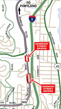
The Oregon Department of Transportation (ODOT) plans to spend $5 million to rehabilitate and repave the Vermont and Newbury bridges on SW Barbur Blvd just south of downtown Portland. Southwest neighborhood activists, the Bicycle Transportation Alliance, the Portland Bureau of Transportation and others see the project as a golden opportunity to improve bike access on the bridges; but so far, ODOT has no such improvements in their plans.
At issue is that the existing bike lanes on SW Barbur Blvd suddenly disappear over each of the viaducts. This lack of a bike lane on the bridges means people on bicycles must squeeze dangerously close to motor vehicle traffic that travels at 55 mph. These conditions are hair-raising for people that use them today and they’re exactly the type of thing that prevents people from biking in the first place.
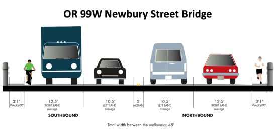
Over the bridges, Barbur has four standard travel lanes (two are 10-1/2 feet, two are 12-1/2 feet) over the bridges and a three foot sidewalk on each side.
Here’s a graphic (from ODOT) of the cross-section as it stands today:
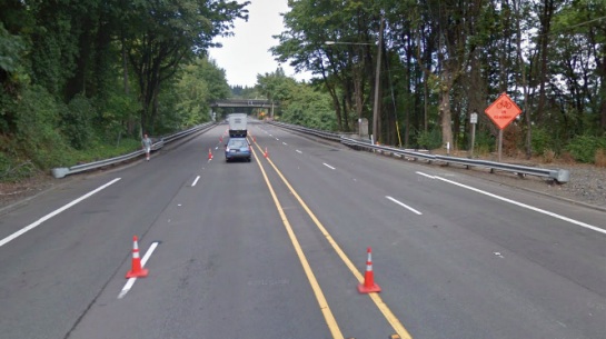
And here’s a Google Streetview image of the northbound approach to the Newbury St. Bridge (note how the bike lanes drop):
Neighborhood activists, led by veteran bike advocates Keith Liden and Roger Averbeck (both of whom are on the PBOT Bicycle Advisory Committee) want ODOT to consider a road diet or other options to make room for bike lanes. Over a year ago, Liden asked ODOT to investigate this (and other) possibilities for Barbur and, “he essentially got brushed off” he says.
Frustrated with the agency, Liden stopped pursuing the idea. But now, with the bridge repair project on the table, he’s giving it one last try. “I’m pushing this because I feel the stakes are high,” Liden says. He feels the existing bike access is “horrible” and the Vermont/Newbury Bridge project is a chance to get relatively low-cost improvements in a short timeframe.
Liden also has the support of the Barbur Concept Plan which was recently completed by the City of Portland’s Bureau of Planning and Sustainability. The plan, which is set for City Council adoption any week now, states:
“Despite the modest grades and presence of bike lanes in much of the segment, the motor vehicle speeds, missing bike lanes on the two viaducts and turning conflicts for southbound motorists heading to Capitol Hwy make conditions unattractive for those who might consider bicycling. People on bicycles would benefit from greater buffering or separation from the travel lanes, as evidenced by several stretches where bike lane striping has been worn away by errant vehicle tires. In addition to accommodations on the Vermont and Newberry viaducts, pedestrians need either a completed sidewalk network or a parallel accessible pathway.”
The Portland Bike Plan for 2030 also calls for Barbur to be a major city bikeway.
For their part, ODOT says they need the auto capacity on SW Barbur. To reduce lane widths and/or remove standard lanes entirely would cause congestion during peak traffic hours, according to an ODOT traffic modeling analysis. ODOT Community Affairs rep Jilayne Jordan addressed this in a recent article in The Oregonian:
“Barbur is the alternate route to Interstate-5, and “We don’t like to reduce capacity on those routes,” said ODOT’s Jordan.”
In addition to saying they do not want to reduce motor vehicle capacity in any way, ODOT says there’s “no funding available” to replace or widen the bridges, or to build separate bicycle-only bridges. ODOT says the $5 million already dedicated to the project comes from bridge rehab-specific funding sources.
At an open house for this project last month, ODOT acknowledged the bike access issue on the poster below:
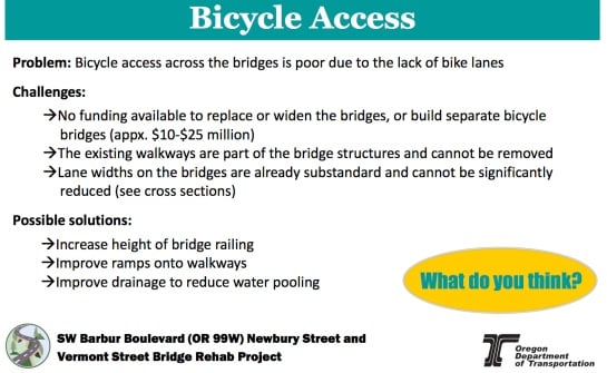
One option ODOT has said they’ll consider is improving the ramps up to the existing sidewalk and widening it to five feet. Beyond that, sources say ODOT wants to consider the road diet idea separate from the bridge rehab project and they’re encouraging bike advocates to take their concerns to the SW Corridor planning process.
ODOT is slated to present this project at tonight’s PBOT Bicycle Advisory Committee meeting. Stay tuned for more coverage.


Thanks for reading.
BikePortland has served this community with independent community journalism since 2005. We rely on subscriptions from readers like you to survive. Your financial support is vital in keeping this valuable resource alive and well.
Please subscribe today to strengthen and expand our work.
Just in case Beth Slovic is reading this, remember these expenditures (like most we discuss here) would be entirely defensive; necessitated only by the overwhelming(ly dangerous) presence of the automobile.
“Barbur is the alternate route to Interstate-5, and “We don’t like to reduce capacity on those routes,” said ODOT’s Jordan.
Nice. With friends like these…
Since ‘we’ can’t use Interstate-5, how about you take off those car-tinted goggles–the ones that prevent your from seeing the rest of us not in cars?
What do I think?
I wish you (at ODOT) would leave the 20th Century and Eisenhower’s mindset behind and join us for some bike rides down Barbur one morning.
As someone that grew up very close to this area and used Barbur regularly, I can confidently say that normal traffic patterns do not require two northbound lanes in the area of these bridges. Just north of the intersection with Brier Pl, the right northbound lane could be dropped, allowing for buffered bike lanes over both bridges. North of the Capital HWY flyover, only two northbound lanes are necessary until you get within 1000ft of the Hamilton signal. This would allow for buffer areas for the majority of this section.
The problem for ODOT is a situation where there is a bad collision on I-5N in the Terwilliger curves. This happens quite frequently in wet weather, and Barbur is used as an alternate route.
That was exactly my idea, too. Get rid of one southbound lane just after the Capitol Hwy ramp, as 50% of traffic turns right here anyway. Use the exta lane to prvide buffered bikelanes on both side of the street over the two bridges. I also think that three traffic lanes north of Capitol Hwy is total overkill and contributes to the 55 mph speed. 95% of the time Barbur is totally underused in the “woods” section.
It’s not “Eisenhower’s mindset”. The Interstate Highway system as envisioned and proposed by Eisenhower was intended to be intracity only – not within the city limits. It was Robert Moses and other planners in the late 1950s / 1960s who came up with the nightmare system we have today.
point taken.
A great article on Robert Moses’ NY overpasses
http://zaphod.mindlab.umd.edu/docSeminar/pdfs/Winner.pdf
What about lowering the sidewalk down to road grade. Maybe this would be unpopular but it would reduce complications from the ‘ramps’ – even ‘improved ramps’ would have problems
ok reading more, “the existing walkways are part of the bridge structure and cannot be removed” 🙁 so much for that idea
“the existing walkways are part of the bridge structure and cannot be removed”
This kind of unimaginative thinking is so reminiscent of the early response to the pole in the bikelane on the East end of the Broadway Bridge. First that fellow, Gustafson,* said it was going to cost $200,000 to move it, but in the end it was actually not that hard or expensive. Same here. I bet someone clever (Occupy? – they did alright after Sandy, maybe they could offer some ideas here) could figure out how to augment or modify or substitute something wider and more serviceable for people to cross those bridges who are not in metal boxes. Really – if it were a priority it would have been done for less than some striping, & ten years ago.
*http://bikeportland.org/2012/01/27/streetcar-pole-update-streetcar-director-weighs-in-county-doesnt-like-it-either-66090
As a structural engineer I’m thinking they might mean that the walkways (Notice how they avoid the term “sidewalk,” which is the name of a thing that has a certain mandatory minimum width) are actually the tops of two concrete girders that are helping to carry load. In other words they didn’t build a bridge and then add some purpose-built raised walkways; they built a bridge with girders that people happen to be allowed to walk on. Back in the day, when it was built, that would’ve been praised as achieving multiple goals by taking advantage of concrete’s ability to be cast integrally into any shape.
Anyway if that’s true, grinding them down to make a bike lane would weaken the bridge, and would require an engineering analysis, and if the remaining strength were found lacking, then some sort of strengthening measures would have to be designed, and pretty soon it costs almost as much as widening the bridge.
My favorite cheapish solution would be to add bike lanes and reduce Barbur to 3 car lanes there, with the middle lane northbound in the morning and southbound in the evening. No more substandard lane widths! But there’s no political capital for that, and it’s sort of costly too. The best one for the money is inevitably going to turn out to be improving the ramps and increasing the guardrail height so it’s not so harrowing. Mediocre, I know, but that’s what we’re facing in this time & place.
More than one hundred years ago German engineers figured out how to run an electric monorail upside down through a narrow valley suspended above the river with cast iron girders. It is brilliant and still runs to this day – 25million passenger/yr.
http://en.wikipedia.org/wiki/Wuppertal_Schwebebahn
If they could solve something as difficult as that in the late 19th Century, we can surely figure out how to put comfortably wide bike accommodations, even grade separated, on these bridges in the 21st Century without spending a mint or even removing car lanes–tempting though that may be to some of us. Suspend a large diameter pipe for bikes off the side, for all I care. Just don’t tell us that ‘it can’t be done.’
it’s not that it can’t be done, it’s that it would cost a lot of money…
Well, that sort of boils down to that same thing, doesn’t it, since we (bikey folk) don’t work for the Pentagon.
Well, right, see, now you’re hitting on one of the roots of the real problem aren’t you? If you use the same hackneyed analogy politicians seem to use, where “the federal budget is like a household budget,” then this situation could be stated as “We can’t afford to patch the holes in the roof because Dad went crazy and spent all our money to buy 447 guns.”
At the very least they could add sharrows to the curb-side lanes just as they did on the St Johns-Bridge.
Not sure about your characterization of “substandard” lane widths. Seems to me that the wider the lanes, the faster the traffic. Narrowing the lanes to 10.5″ for every lane could only help make Barbur a better facility.
It’s not my characterization, it’s ODOT’s, from the “Bicycle Access” graphic above.
So I finally made the time to crawl down there under the bridges today. I wanted to understand what was going on with the sidewalks, how they were attached, and what it would take to change/widen/lower/replace them.
The construction is quite interesting. 90% of the structure is wood, including the frame beneath the roadbed itself. Very large, pressure treated beams run parallel to the road & sit atop steel I-beam girders that stick out past the edge of the road, but do not extend the full width of the sidewalk. The sidewalk itself is poured concrete supported by buttresses that curve down to rest on the projecting steel girders. I suspect that rebar connects the roadbed with the sidewalk, that it was all poured together.
Looking at it with the idea of widening the sidewalk, or rather replacing the existing sidewalk with something wider, seems completely doable. I realize ODOT isn’t the least bit interested in creative, inexpensive solutions to things like this, but with the bridge being almost entirely wood and steel it would be a cinch to add the necessary supports to accommodate a wider sidewalk at whatever height relative to the roadway one wished.
My preference would be to cut off the existing concrete sidewalk and bolt a U-shaped steel frame to the outermost beam, resting on the projecting steel girders. The inside vertical leg—aligned with the edge of the road bed—would become the new motor vehicle guard rail; the horizontal leg would become the new bikepath, and the outside vertical leg would keep people biking from falling over the edge.
I took pictures but have no idea how to post them here.
“bicycles must ride in the shoulder, dangerously close to motor vehicle traffic that travels at 55 mph.” Correction: The Speed Limit on Barbur is 45 mph. At the bottom and the top portions it is 35 mph.
RWL1776,
The traffic analysis for this section of Barbur showed that the 85th percentile speed (the speed at which 85% of the traffic travels) is 55 mph.
Actually, that’s the speed above which 15% of the traffic travels. 85% of traffic travels at speeds below 55, in that case.
However, I agree with your original point: if even “only” 10% of cars are going 55 mph, that’s not a lane I want to be sharing with them.
If the speed limit is officially 45mph, then I would expect many vehicles to be travelling closer to 50 or 55mph. Most police will not make an arrest for speed if it’s less than 10mph above the speed limit, is what I tend to hear (school zones etc being an exception).
I thought the same thing, how about some actual enforcement on this road for once! I’m so sick of hearing about roads that are just lost causes, too big/dangerous/fast for the city to actually try to fix them (Sandy and Foster come to mind as well).
…which is the question that arises again and again, why not more speed enforcement? I’m pleased the BTA is pushing for unattended (camera) enforcement at high-crash locations.
Cars routinely go 55 through there; the correction needs to be: there is no shoulder.
Traffic limits and actual vehicle speed have never, ever matched.
When I drive 45 and 35 respectively in Barbur, everybody else is passing me…
Why ODOT don’t just had Barbur over to PBOT is beyond me. Barbur Blvd ceased to act as a “State Highway” moons ago. I-5 now serves that purpose. Barbur is now more of a local street, and should be serviced as such, accordingly. That means, pedestrian and bike improvements, stat.
They can’t. Barbur is a FEDERAL Highway. ODOT can’t just hand it over to PBOT without the approval of the Federal DoT. Good luck with that.
Strike that – I forgot that this part of 99W isn’t Federal anymore. (since 1972)
I always just take the lane at those bridges. Letting cars squeeze past you at 55MPH (and, let’s be serious, 65MPH) at that distance is stupidly dangerous. Granted, so is taking the lane, so I guess using that road at all is stupidly dangerous. I have a hard time seeing how Barbur can become a major city bikeway at all, let alone safely, without fixing those choke points.
Same. I’ve never had any problem with cars letting me merge for 10-20 seconds for those bridges.
A big f’in sharrow gdmit!!!! that place is dangerous when the drivers think the bikes are gonna go up on the narrow sidewalk
there’s not enough traffic to warrant two lanes each way… take one out and put in a buffered bike lane…
even better would be some light rail or streetcar along with the bike lane…
…which of course is how Barbur started out. 🙂
back to basics!
If rail is selected for the SW corridor, it will likely utilize a deep bore tunnel with a subway station for OHSU, bypassing this section of Barbur altogether. If capital is not available, they might select Bus Rapid Transit for the corridor, which would benefit from dedicated lanes to improve reliability. Perhaps in this section, the proper cross section would include buffered bike lanes, one car lane in each direction, and a peak-direction BRT lane in the middle?
Sounds like we need to start flooding ODOT with some phone calls and letters. I agree this is a prime opportunity to improve Barbur and it will be a serious shame if this opportunity is wasted, especially with the improvements to the Sellwood Bridge taking place as I type this.
ODOT needs to quit living in the 1970s. Barbur is no more critical to I-5 as a safety valve than N. Interstate, and we reduced the capacity of that corridor with the yellow line. Meanwhile ODOT has plans to add lanes to the I-5/99W/Barbur interchange for more vehicular capacity at that location while missing the opportunity to add bicycle lanes across the adjacent bridge over I-5. I wish ODOT would give Barbur/Naito to the City and focus its energy on the freeways and regional expressways.
Ah, but in the 1970s ODOT employees biked to work! We have proof. Jonathan’s posted that B&W photo of a full ODOT bike rack before.
I’m sure some still do,* but not enough or at least not the ones that make these larger decisions.
*Dave Apperson was one.
my dad drives over an hour to get to work at ODOT…
I see PBOT listed in the first paragraph as one of the organizations that would like to see a Barbur road diet. Does that not strike anyone else as humorous? I mean, it’s not as if PBOT has set a golden example with the roads it actually does control — maybe they should set an example right now by removing an auto-dedicated lane from SW Broadway and installing a 2-way separated cycle track from PSU to the bridge? 😉
Riding that stretch for 4.5 years (except summers) to Lewis and Clark and never had a conflict. Motor traffic is pretty much backed up during commute times to make the bridges a non issue, though I could see how it would be intimidating to some.
Shame about that “color of money” issue that only dedicates certain funds to certain specific projects.
I always recommend riding Terwilliger through that area. Barbur does not feel safe and certainly isn’t a pleasant ride.
WIth that said, I wonder how N Interstate was able to become a community main street instead of an “alternative to I-5”? What is different about Barbur? Same question for Macadam. It seems to me that we just encourage people to commute from places like Sherwood by doing that, thereby creating even more traffic.
I didn’t think that N Interstate was a state highway…
although they did put in traffic calming on MLK, which is a state highway… but no bike lanes…
Two thumbs up to the Road Diet.
There’s no need for two downhill car lanes through here.
Vancouver, WA did this on Highway 99 under the Chehatchie Prairie railroad bridge with excellent results. It was 4 lanes, no bike lane, steep hill. Now it’s 2 bike lanes, 2 uphill lanes, 1 downhill lane.
See it at
https://maps.google.com/?ll=45.663533,-122.664865&spn=0.000517,0.001422&t=h&z=20&layer=c&cbll=45.663533,-122.664865&panoid=vZxFEwChEXrqsI2sCdHUtQ&cbp=11,12.84,,0,1.93
Ted Buehler
That’s a great example. It’s interesting that they neck-down to the three lane design for only a short distance. At the very least, Barbur could do the same to traverse the bridges if they weren’t ready to commit to a road diet along the full length.
Yup, no need to do it for the full length. I suspect that the capacity constraints on NB Barbur are at the intersections, not in the limited access section where the two bridges are.
The Vancouver WA example is 2009 or 2010, BTW. Very recent — it’s not something that was done in the distant past.
Ted Buehler
Ah, for the love of…I will always keep the stance on projects like this in mind when I see/read/hear about Portland being the “best” biking city in the nation. Barbur should have been solved years ago.
I graduated from Wilson High School and lived in the Hillsdale and Wilson Park neighborhoods for big chunks of my life. I’ve bicycle and car commuted up/down Barbur at all hours and have even switched that up with Terwilliger and Corbett when Barbur just seemed too dangerous (those routes have their own major dangers and have the bonus of taking forever and a day).
It’s obvious to me that Barbur is the ONLY reasonable bicycle corridor between this part of SW Portland and the downtown core and the bridge access is atrocious and will eventually lead to a major accident and death. ODOT has absolutely no clue about how cities work if they think that improved bicycle access on Barbur is a low priority.
Barbur needs a segregated, fully continuous bicycle path. That’s the only reasonable idea.
But, knowing ODOT, they don’t give a fig about human beings unless they’re in a car. One less than ideal compromise to keep in your back pocket would be for sharrows and warning lights starting at the intersections before the choke points to direct cars to the centermost lanes. Capitol Highway and its downhill on-ramp to Barbur need to be a sharrow if it isn’t already, with triggerable warning lights and a bicycle signal at Capitol and Terwilliger to give bikes a 30 second head start against cars on Capitol and cars turning onto Capitol from Terwilliger so they don’t get tailgated on the curvy parts.
The outside lane on the bridges should be a sharrow with warning lights that either trigger automatically when a bicyclist is sensed in the bike lane or that are triggered at 3rd and Terwilliger. (No bicyclist is going to slow down their momentum to push a button before the bridge unless they’re already stopped on a flat part at a light.) Cars need to be directed to the inside lanes. Heck, I’ve car commuted on Barbur during peak hours and even then it barely needs four lanes. Triggers on the uphill direction can be a little closer to the bridges because there’s not as much momentum.
Expecting a downhill cyclist to navigate onto a sidewalk ramp is going to end up with someone getting hurt as well. Barbur (like pretty much all ODOT roads) is so unfriendly to pedestrians, the current tiny sidewalks are laughable.
Growing up in SW Portland and trying to explain to people where I’m from always got blank stares. I actually read in a tour guide one time, “SW Portland — not really anything to see here unless you have a lot of extra time.” There’s a reason why SW Portland hasn’t caught up to the Portland livability renaissance and poor transportation access is a big part of that.
“I’ve car commuted on Barbur during peak hours and even then it barely needs four lanes.”
This is my neighborhood too and this is exactly my experience. And for whose benefit? Mostly the few people who live in a small pocket of SW and work downtown. Well that’s ME and I have no need for 4+ lanes on Barbur. It’s just too much road.
Barbur made sense as a highway before I-5. It needs to be a street.
Skwirl et al, ROAD DIET for Barbur Bridges. PLEASE help spread the word in SW Portland and contact ODOT via
Jilayne Jordan
Community Affairs Coordinator
ODOT – Region 1
(503) 731-8237
jilayne.jordan@odot.state.or.us
Public comment is presently scheduled to close on January 15th. I find this outrageous and offensive given that ODOT suggested they had contacted SW Neighborhoods about the bridge repair project. I can assure you they have not as I was not contacted by ODOT at all as chair of a SW Neighborhood (Markham) nearly bordering Barbur and just got off the phone w/ South Burlingame NA Chair who was also not contacted by ODOT.
ODOT/Jilayne NEEDS to be flooded by phone calls & emails from SW Portland residents and members of the SW business community calling for the proposed Road Diet on the bridges, which, if you give it much thought, is a complete no-brainer. I also suggest you contact Mayor Hales & PBOT. Remember Mayor Hales campaigned on the promise to reach across to other regional leaders to make things happen!
Here is the rationale for a Northbound lane ROAD DIET:
A) The Northbound lane is inevitably underutilized vs. the Southbound lane. Why? Vehicles can more quickly access downtown from SW Portland via
1) I-5 onramp from SW Multnomah Blvd 2) I-5 onramp at SW 5th & Terwilliger 3) I-5 onramp at SW Bertha & Barbur 4) I-5 onramp at SW Capitol Highway & Huber 5) I-5 onramp at 21st & Spring Garden
or Vehicles can take a more leisurely route to downtown via 1) Capitol Highway onramp to Barbur 2) Barbur, Fulton, Corbett, Macadam 3) Taylors Ferry, Macadam 4) Dosch, Broadway
What do these 9 access points to downtown from SW have in common? NONE of them utilize the Vermont/Newbury Bridges! Therefore, 2 lanes in the Northbound is really unnecessary and reducing to 1 would allow for the 2 Southbound lanes to shift over.
B) What is the biggest contributor to slowdowns and bottlenecks in traffic? Traffic lights of course. Point being, the nearest Northbound traffic light is a mile away! Therefore, the likelyhood that a lane reduction would actually impede traffic flow is fear-base speculation at best. Northbound traffic will inevitably be stopped or slowed by lights at Fulton and Hamilton, NOT by Northbound lane reduction.
C) Motorists do not actually like dealing with bicyclists taking the lane. If you are a law-abiding driver doing 45 mph in either section this is STRESSFUL, to the right you’ve got a slower cyclist you are hoping not to kill, to the left or behind you’ve got Johnny Leadfoot wanting to drive 55 mph (85% of the time) What a relief it would be as a driver to not have to worry about cyclists. According to my calculations a conservative estimate of the distance from point to point on the bridges is .4 miles, meaning in a car going 45 mph this section takes 32 seconds to cross. 32 SECONDS! We are talking about Life & Death, More Stress or Less Stress for ALL!
D) As has been mentioned, Barbur Blvd. is THE most logical route for cyclists to SW as it is the ONLY road that is relatively straight and has an also relevantly constant grade. Furthermore there is already a high number of riders in the corridor (mostly male), yet if you ask most who live in SW they will tell you these bridges alone are an absolute DEAL BREAKER for considering a bike commute up/down Barbur so they therefore take the bus, carpool or drive themselves (most often on I-5). Think about capturing this audience (95%+ of SW Portland residents?) What about women, children and seniors feeling and being safer along the corridor?
E) Good for business. Businesses along Barbur, in Multnomah (Village), Hillsdale & South Burlingame should salivate at the possibility of better access/options for ALL of Portland to access their establishments.
F) ODOT proposal includes taking 6 inches off the right-hand Northbound lane. With the current configuration EVERY inch is critical for cyclists and motorists alike in that right hand Northbound lane. The Southbound sidewalk improvements may make people riding feel safer going in that direction, but what about if they encounter a pedestrian going the other direction? 5 feet better be enough to squeeze by!
G) Redo: Here is the beauty of a ROAD DIET for the bridges! It would be extremely LOW COST! Paint, signage, what else? Would $90K be enough?
Make no mistake, a ROAD DIET for these 2 bridges would be an absolute GAMECHANGER for SW Portland, The City of Portland and even the State. Most likely ODOT is afraid of losing motor vehicle registration fees by implementing such a fantastic project.
In the meantime I promise to advocate for this and spread this message all over until it is done!
ODOT continues to confuse capacity and congestion. A road diet will not reduce capacity, but it will reduce speeds – an outcome that will benefit all users.
I’m grateful for people like Keith Liden and Roger Averbeck for their leadership on this issue.
jr
I ride Barbur often. I will say traffic is very fast on those bridges but it is never a problem for an experienced cyclist to merge for 5-10 seconds. The chewed up pavement ON the bridges causes more of a problem. At a minimum, if they put long and shallow sloped entrance/exit ramps to the raised sidewalk that would probably negate 90% of the danger. If I had to slowdown to 10-15 mph downhill to enter/exit it wouldn’t be that much of an issue and experienced cyclists could travel northbound at full speed (albeit the sidewalks are a bit narrow).
I am a regular bike commuter in Spring and Summer using Barbur between Tigard and NW Portland via Naito. I car commute in the bad weather months, and I can attest to excessive speeds. Every day. Barbur is no longer a highway, and speeds need to be reduced to make it safer for cyclists, pedestrians, and Trimet riders throughout this stretch. These bridge passages need lighting and safe lanes for cyclists, as Barbur is the only viable commuting corridor into downtown, and improvements will only be that much more expensive if ODOT fails to address these necessary improvements now.
Isn’t there an alternate route for motor vehicle traffic that runs almost parallel to Barbur Blvd? It’s name escapes me, but I heard about this high speed, high budget, high capacity, no traffic controls thoroughfare, darn this age addled brain of mine….called a “free” whotsit” or something like that.
Isn’t there an alternate route for motor vehicle traffic that runs almost parallel to Barbur Blvd? It’s name escapes me, but I heard about this high speed, high budget, high capacity, no traffic controls thoroughfare, darn this age addled brain of mine….called a “free” wotsit or some such. One of them “modern” ideas, supposed to make car commuting care-free.
ODOT needs to recognize that because there are almost no intersections along this stretch, it effectively functions like a bridge, with about twice the capacity per lane as a similar road with intersections.
Barbur does often gets congested, but only at intersections. I’ve NEVER seen its service level even remotely approach degradation between Hamilton and Miles (Burlingame) except at the ends of that stretch where the stoplights are. As long as it still has multiple lanes on the approaches to major intersections, there is absolutely NO need for it to have two motor vehicle lanes each way on the stretch in question.
This is my route when I drive to work, and as someone who actually observes (or even remains below) the speed limit I can attest that MANY vehicles exceed the 45mph maximum south of the new HAWK signal) by a wide margin. 55mph is not at all unusual, and Jon was right to cite that speed. Fortunately the shoulder/bike lane is relatively wide, and in the downhill direction bike speeds are 20-30mph, so I will say that as a cyclist I’ve never felt threatened by the speeds of motor vehicles in the other lanes.
It’s on the bridges where vehicle speeds really drive home the perception of danger. I do bike this part of Barbur frequently, as it’s part of my preferred summer route home. Although I am paranoid about conflicts when I take the lane over these bridges, SO FAR I have never had a problem, and most drivers seem to change lanes well before they get to me. It helps that traffic volumes are so low, but somehow it always feels like a matter of time before I find myself on one of the bridges at the wrong time and end up in an altercation with some speedhead.
Personally, I would GLADLY ride the sidewalks of these two bridges — as I do on the Ross Island Bridge about 5 minutes later into my commute — if only they had better ramps and higher railings. The only reason I do take the lane here is because of the horrible ramps and low railings.
I certainly would like to see ODOT pursue a road diet here, and I don’t at all buy their arguments against the idea. But I also don’t like making the perfect the enemy of the good, and even the changes ODOT is proposing will make a night-and-day improvement to the safety of riding on Barbur. It will change from “completely unacceptable” to “marginally acceptable” in a part of town where alternate routes either don’t exist or are beyond unacceptable, and I’ll still welcome it.
Of course, any competent traffic engineer knows that neither 12.5′ lanes nor a 2′ median is required on this road. ODOT could easily widen those walkways to 5 feet while keeping all 4 vehicle lanes at standard width. They just *like* the 12.5′ lanes – hey, the wider the better, right???
I don’t understand the necessity for all of these huge monstrous wide roads through this area. It is without fail absolutely the most hideous quadrant of the city. You have the I-5 freeway. You have Macadam. You have Naito. You have Barbur Blvd. They all parallel each other within blocks. And not one, count it, ONE of them has bike access I would want to risk my life on. What ODOT fail to understand is, there is no grid system in this part of the city. It’s Barbur, or bust if you’re on a bike.
Email the project contact : ;
JM – Any update after that presentation to the BAC? Did the BAC or members of the public have any useful comments or critiques? How did ODOT react?
Hi Henefer,
The BAC meeting was interesting. I’ll have a story on it tomorrow.